ArxivLens

Quick Summary:

This paper reviews over 500 publicly available Earth observation datasets across various research domains and proposes a new benchmark platform called EarthNets for evaluating deep learning methods in remote sensing, offering a fair and consistent evaluation environment. The platform and dataset collections are openly accessible to support future research.

arXiv Id: 2210.04936
Comments: 30 pages
Date Published: 2024-04-04
Date Updated: 2024-04-04

Categories:

Key Terms (TF-IDF):

remote sensing (0.258)
remote (0.221)
sensing (0.198)
platform (0.189)
datasets (0.163)
learning methods (0.162)
deep learning (0.160)
research (0.159)
domains (0.156)
publicly (0.150)
earth (0.146)
monitoring (0.146)
published (0.144)
dataset (0.138)
deep (0.131)
benchmark (0.124)
learning (0.124)
evaluation (0.116)
climate (0.112)
living (0.104)
License: http://creativecommons.org/licenses/by/4.0/

Summary:

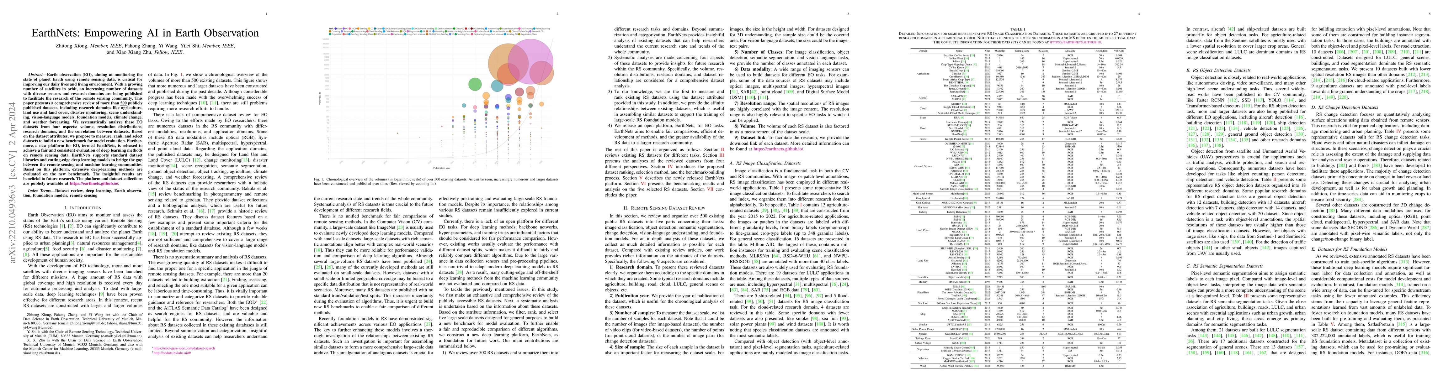
Earth observation (EO), aiming at monitoring the state of planet Earth using remote sensing data, is critical for improving our daily lives and living environment. With a growing number of satellites in orbit, an increasing number of datasets with diverse sensors and research domains are being published to facilitate the research of the remote sensing community. This paper presents a comprehensive review of more than 500 publicly published datasets, including research domains like agriculture, land use and land cover, disaster monitoring, scene understanding, vision-language models, foundation models, climate change, and weather forecasting. We systematically analyze these EO datasets from four aspects: volume, resolution distributions, research domains, and the correlation between datasets. Based on the dataset attributes, we propose to measure, rank, and select datasets to build a new benchmark for model evaluation. Furthermore, a new platform for EO, termed EarthNets, is released to achieve a fair and consistent evaluation of deep learning methods on remote sensing data. EarthNets supports standard dataset libraries and cutting-edge deep learning models to bridge the gap between the remote sensing and machine learning communities. Based on this platform, extensive deep-learning methods are evaluated on the new benchmark. The insightful results are beneficial to future research. The platform and dataset collections are publicly available at https://earthnets.github.io.

Citation & Reference Network Visualization

This graph shows how this paper is connected to other research. The current paper is shown in dark gray, papers that cite it are in green, and papers it references are in blue. You can:

Current Paper
Papers citing this work (Citations)
Papers cited by this work (References)

• Hover over any node to see the paper title

• Click a node to view that paper's details

• Drag nodes to rearrange the graph

• Use the zoom controls (bottom right) to zoom in/out

Citations and References

Title Authors Year Actions
Urban Flood Mapping Using Satellite Synthetic Aperture Radar Data: A review of characteristics, approaches, and datasets
Jie Zhao, Ming Li, Yu Li, P. Matgen, M. Chini
2024
View Paper
Communication-Efficient Satellite-Ground Federated Learning Through Progressive Weight Quantization
Chenchen Yang, Jinliang Yuan, Yaozong Wu, Qibo Sun, Ao Zhou, Shangguang Wang, Mengwei Xu
2024
View Paper
Radiation Anomaly Detection of Sub-Band Optical Remote Sensing Images Based on Multiscale Deep Dynamic Fusion and Adaptive Optimization
Jinlong Ci, Hai Tan, Haoran Zhai, Xinming Tang
2024
View Paper
NTL-Unet: A Satellite-Based Approach for Non-Technical Loss Detection in Electricity Distribution Using Sentinel-2 Imagery and Machine Learning
Matheus Felipe Gremes, Renato Couto Gomes, Andressa Ullmann Duarte Heberle, Matheus Alan Bergmann, Luísa Treptow Ribeiro, Janice Adamski, Flávio Alves dos Santos, André Vinicius Rodrigues Moreira, Antonio Manoel Matta dos Santos Lameirão, Roberto Farias de Toledo, Antonio Oseas de C. Filho, Cid Marcos Gonçalves Andrade, Oswaldo Curty da Motta Lima
2024
View Paper
Towards Large-Scale Urban Flood Mapping Using Sentinel-1 Data
Jie Zhao, Xiao Xiang Zhu
2024
View Paper
Referring Image Segmentation for Remote Sensing Data
Zhenghang Yuan, Lichao Mou, Yuansheng Hua, Xiao Xiang Zhu
2024
View Paper
Vigen500k: A Sustainable-Expansion Image-Text Aligned Dataset For Remote Sensing
Boyuan Tong, Runyan Du, Wenkai Zhang, Jihao Li, Shuoke Li, Chongyang Li, Zhi Guo, Xian Sun, Guangluan Xu
2024
View Paper
Disentangling Semi-Supervised Semantic Segmentation of Remote Sensing Images
Wei Huang, Yilei Shi, Zhitong Xiong, Xiao Xiang Zhu
2024
View Paper
Merging Patches and Tokens: A VQA System for Remote Sensing
Damian Falk, Kaan Aydin, L. Scheibenreif, Damian Borth
2024
View Paper
TorchSpatial: A Location Encoding Framework and Benchmark for Spatial Representation Learning
Nemin Wu, Qian Cao, Zhangyu Wang, Zeping Liu, Yanlin Qi, Jielu Zhang, Joshua Ni, Xiaobai Yao, Hongxu Ma, Lan Mu, Stefano Ermon, T. Ganu, A. Nambi, Ni Lao, Gengchen Mai
2024
View Paper
UrbanSARFloods: Sentinel-1 SLC-Based Benchmark Dataset for Urban and Open-Area Flood Mapping
Jie Zhao, Zhitong Xiong, Xiao Xiang Zhu
2024
View Paper
Global High Categorical Resolution Land Cover Mapping via Weak Supervision
Xin-Yi Tong, Runmin Dong, Xiao Xiang Zhu
2024
View Paper
On the Foundations of Earth and Climate Foundation Models
Xiao Xiang Zhu, Zhitong Xiong, Yi Wang, Adam J. Stewart, Konrad Heidler, Yuanyuan Wang, Zhenghang Yuan, Thomas Dujardin, Qingsong Xu, Yilei Shi
2024
View Paper
Neural Plasticity-Inspired Multimodal Foundation Model for Earth Observation
Zhitong Xiong, Yi Wang, Fahong Zhang, Adam J. Stewart, Joelle Hanna, Damian Borth, Ioannis Papoutsis, B. L. Saux, G. Camps-Valls, Xiao Xiang Zhu
2024
View Paper
Multi-Spectral Remote Sensing Image Retrieval Using Geospatial Foundation Models
Benedikt Blumenstiel, Viktoria Moor, Romeo Kienzler, Thomas Brunschwiler
2024
View Paper
Convergence Time Optimization for Decentralized Federated Learning With LEO Satellites via Number Control
Zhi-Hui Yan, Dong Li
2024
View Paper
ChatEarthNet: A Global-Scale Image-Text Dataset Empowering Vision-Language Geo-Foundation Models
Zhenghang Yuan, Zhitong Xiong, Lichao Mou, Xiao Xiang Zhu
2024
View Paper
When geoscience meets generative AI and large language models: Foundations, trends, and future challenges
A. Hadid, Tanujit Chakraborty, Daniel Busby
2024
View Paper
Resource-efficient In-orbit Detection of Earth Objects
Qiyang Zhang, Xin Yuan, Ruolin Xing, Yiran Zhang, Zimu Zheng, Xiao Ma, Mengwei Xu, S. Dustdar, Shangguang Wang
2024
View Paper
SkyEyeGPT: Unifying Remote Sensing Vision-Language Tasks via Instruction Tuning with Large Language Model
Yangfan Zhan, Zhitong Xiong, Yuan Yuan
2024
View Paper
One for All: Toward Unified Foundation Models for Earth Vision
Zhitong Xiong, Yi Wang, Fahong Zhang, Xiao Xiang Zhu
2024
View Paper
Language Integration in Remote Sensing: Tasks, datasets, and future directions
Laila Bashmal, Y. Bazi, F. Melgani, M. M. Al Rahhal, M. A. Al Zuair
2023
View Paper
Feature Guided Masked Autoencoder for Self-Supervised Learning in Remote Sensing
Yi Wang, Hugo Hern'andez Hern'andez, C. Albrecht, Xiao Xiang Zhu
2023
View Paper
On the Transferability of Learning Models for Semantic Segmentation for Remote Sensing Data
Rongjun Qin, Guixiang Zhang, Yang Tang
2023
View Paper
HTC-DC Net: Monocular Height Estimation From Single Remote Sensing Images
Sining Chen, Yilei Shi, Zhitong Xiong, Xiaoxiang Zhu
2023
View Paper
Few-Shot Object Detection in Remote Sensing: Lifting the Curse of Incompletely Annotated Novel Objects
Fahong Zhang, Yilei Shi, Zhitong Xiong, Xiaoxiang Zhu
2023
View Paper
There Are No Data Like More Data: Datasets for deep learning in Earth observation
Michael Schmitt, S. A. Ahmadi, Yonghao Xu, G. Taşkın, Ujjwal Verma, F. Sica, R. Hänsch
2023
View Paper
SSL4EO-S12: A large-scale multimodal, multitemporal dataset for self-supervised learning in Earth observation [Software and Data Sets]
Yi Wang, Nassim Ait Ali Braham, Zhitong Xiong, Chenying Liu, C. Albrecht, Xiaoxiang Zhu
2023
View Paper
Parameter-Efficient Transfer Learning for Remote Sensing Image–Text Retrieval
Yuan Yuan, Yangfan Zhan, Zhitong Xiong
2023
View Paper
An OGC TrainingDML-AI approach for making EO training datasets ready in deep learning frameworks
Shuaiqi Liu, P. Yue, Hanwen Xu, Liangcun Jiang, R. Liu
2023
View Paper
Exploring Geometric Deep Learning for Precipitation Nowcasting
Shan Zhao, Sudipan Saha, Zhitong Xiong, Niklas Boers, Xiaoxiang Zhu
2023
View Paper
Adaptive Bins for Monocular Height Estimation from Single Remote Sensing Images
Sining Chen, Yilei Shi, Zhitong Xiong, Xiao Xiang Zhu
2023
View Paper
Polyhedron-Based Graph Neural Network for Compact Building Model Reconstruction
Zhaiyu Chen, Yilei Shi, Zhitong Xiong, Xiao Xiang Zhu
2023
View Paper
Introducing DLR Hysu - A Benchmark Dataset for Spectral Unmixing
D. Cerra, M. Pato, Kevin Alonso, C. Köhler, Mathias Schneider, Raquel De los Reyes, E. Carmona, Rudolf Richter, Franz Kurz, Rupert Müller, P. Reinartz
2023
View Paper
A Safeguard and Safety in E-Health Records: A Committed Clinch
Mazin R. AL-Hameed, Waleed H. Madhloom, A. H. Hussein, Manar Hussan, Muntather Almusawi, E. A. Mohammed
2023
View Paper
RRSIS: Referring Remote Sensing Image Segmentation
Zhenghang Yuan, Lichao Mou, Yuansheng Hua, Xiao Xiang Zhu
2023
View Paper
Evaluation of Modern Deep Learning Architectures in Remote Sensing Scene Classification
G. Taşkın, Hüseyin Kaya
2023
View Paper
GEO-Bench: Toward Foundation Models for Earth Monitoring
Alexandre Lacoste, Nils Lehmann, Pau Rodríguez López, Evan D. Sherwin, H. Kerner, Bjorn Lutjens, J. Irvin, David Dao, H. Alemohammad, Alexandre Drouin, Mehmet Gunturkun, Gabriel Huang, David Vázquez, Dava Newman, Y. Bengio, Stefano Ermon, Xiao Xiang Zhu
2023
View Paper
RSSOD-Bench: a Large-Scale Benchmark Dataset for Salient Object Detection in Optical Remote Sensing Imagery
Zhitong Xiong, Yanfeng Liu, Q. Wang, Xiao Xiang Zhu
2023
View Paper
Overcoming Language Bias in Remote Sensing Visual Question Answering Via Adversarial Training
Zhenghang Yuan, Lichao Mou, Xiao Xiang Zhu
2023
View Paper
GAMUS: A Geometry-aware Multi-modal Semantic Segmentation Benchmark for Remote Sensing Data
Zhitong Xiong, Sining Chen, Yi Wang, Lichao Mou, Xiao Xiang Zhu
2023
View Paper
Towards Impactful Applications of AI4EO in the Global South
Isabelle Tingzon, James Matthew Miraflor, Xiao Xiang Zhu, M. Kochupillai
2023
View Paper
Long-tailed Regression with Ensembles for Monocular Height Estimation from Single Remote Sensing Images
Sining Chen, Yilei Shi, Xiao Xiang Zhu
2023
View Paper
Pseudo Features Guided Self-training for Domain Adaptive Semantic Segmentation of Aerial Images
Fahong Zhang, Yilei Shi, Zhitong Xiong, Xiao Xiang Zhu
2023
View Paper
Biomass Estimation and Uncertainty Quantification From Tree Height
Qian Song, C. Albrecht, Zhitong Xiong, Xiao Xiang Zhu
2023
View Paper
Vision-Language Models in Remote Sensing: Current progress and future trends
Congcong Wen, Yuan Hu, Xiang Li, Zhenghang Yuan, Xiao Xiang Zhu
2023
View Paper
SATIN: A Multi-Task Metadataset for Classifying Satellite Imagery using Vision-Language Models
J. Roberts, Kai Han, Samuel Albanie
2023
View Paper
Multilingual Augmentation for Robust Visual Question Answering in Remote Sensing Images
Zhenghang Yuan, Lichao Mou, Xiao Xiang Zhu
2023
View Paper
Multi-Modal Learning for Geospatial Vegetation Forecasting
V. Benson, C. Requena-Mesa, Claire Robin, Lazaro Alonso, Jos'e A. Cort'es, Zhihan Gao, Nora Linscheid, M. Weynants, M. Reichstein
2023
View Paper
Multimodal and Multiresolution Data Fusion for High-Resolution Cloud Removal: A Novel Baseline and Benchmark
Fang Xu, Yilei Shi, Patrick Ebel, Wen Yang, Xiao Xiang Zhu
2023
View Paper
Scale-MAE: A Scale-Aware Masked Autoencoder for Multiscale Geospatial Representation Learning
Colorado Reed, Ritwik Gupta, Shufan Li, S. Brockman, Christopher Funk, Brian Clipp, Salvatore Candido, M. Uyttendaele, Trevor Darrell
2022
View Paper
SSL4EO-S12: A Large-Scale Multi-Modal, Multi-Temporal Dataset for Self-Supervised Learning in Earth Observation
Yi Wang, Nassim Ait Ali Braham, Zhitong Xiong, Chenying Liu, C. Albrecht, Xiao Xiang Zhu
2022
View Paper
RSVG: Exploring Data and Models for Visual Grounding on Remote Sensing Data
Yangfan Zhan, Zhitong Xiong, Yuan Yuan
2022
View Paper
Aerial View Localization with Reinforcement Learning: Towards Emulating Search-and-Rescue
Aleksis Pirinen, A. Samuelsson, John Backsund, Kalle Åström
2022
View Paper
Enabling country-scale land cover mapping with meter-resolution satellite imagery
Xin-Yi Tong, Guisong Xia, Xiaoxiang Zhu
2022
View Paper
VGRSS: Datasets and Models for Visual Grounding in Remote Sensing Ship Images
Yaxiong Chen, Liwen Zhan, Yichen Zhao, Shengwu Xiong, Xiaoqiang Lu
2025
View Paper
Weakly Supervised Remote Sensing Image Semantic Segmentation With Pseudo-Label Noise Suppression
Xiao Lu, Zhiguo Jiang, Haopeng Zhang
2024
View Paper
Self-Supervised Pretraining With Monocular Height Estimation for Semantic Segmentation
Zhitong Xiong, Sining Chen, Yilei Shi, Xiao Xiang Zhu
2024
View Paper
Land Cover Classification From Sentinel-2 Images With Quantum-Classical Convolutional Neural Networks
Fan Fan, Yilei Shi, Xiao Xiang Zhu
2024
View Paper
Neural Plasticity-Inspired Foundation Model for Observing the Earth Crossing Modalities
Zhitong Xiong, Yi Wang, Fahong Zhang, Adam J. Stewart, Joelle Hanna, Damian Borth, Ioannis Papoutsis, B. L. Saux, G. Camps-Valls, Xiao Xiang Zhu
2024
View Paper
Visual Contextual Semantic Reasoning for Cross-Modal Drone Image-Text Retrieval
Jinghao Huang, Yaxiong Chen, Shengwu Xiong, Xiaoqiang Lu
2024
View Paper
Semantic-Explicit Filtering Network for Remote Sensing Image Change Detection
Shuying Li, Chao Ren, Yuemei Qin, Qiang Li
2024
View Paper
High-Resolution Cloud Removal with Multi-Modal and Multi-Resolution Data Fusion: A New Baseline and Benchmark
Fang Xu, Yilei Shi, Patrick Ebel, Wen Yang, Xiao Xiang Zhu
2023
View Paper
Visual Question Generation From Remote Sensing Images
Laila Bashmal, Y. Bazi, F. Melgani, Riccardo Ricci, M. M. Al Rahhal, M. Zuair
2023
View Paper
Distilling Knowledge From Super-Resolution for Efficient Remote Sensing Salient Object Detection
Yanfeng Liu, Zhitong Xiong, Yuan Yuan, Qi Wang
2023
View Paper
DCI-PGCN: Dual-Channel Interaction Portable Graph Convolutional Network for Landslide Detection
Weiming Li, Yibin Fu, Shuaishuai Fan, Mingrui Xin, Hongyang Bai
2023
View Paper
Pseudo Features-Guided Self-Training for Domain Adaptive Semantic Segmentation of Satellite Images
Fahong Zhang, Yilei Shi, Zhitong Xiong, Wei Huang, Xiao Xiang Zhu
2023
View Paper
One Model Is Enough: Toward Multiclass Weakly Supervised Remote Sensing Image Semantic Segmentation
Zhenshi Li, Xue-liang Zhang, P. Xiao
2023
View Paper
Transcending Pixels: Boosting Saliency Detection via Scene Understanding From Aerial Imagery
Yanfeng Liu, Zhitong Xiong, Yuan Yuan, Qi Wang
2023
View Paper
GFM: Building Geospatial Foundation Models via Continual Pretraining
Mat'ias Mendieta, Boran Han, Xingjian Shi, Yi Zhu, Chen Chen, Mu Li
2023
View Paper
Aerial View Goal Localization with Reinforcement Learning
Aleksis Pirinen, A. Samuelsson, John Backsund, Kalle Åström
2022
View Paper
ISPRS Journal of Photogrammetry and Remote Sensing
Xin-Yi Tong, Gui-Song Xia, Xiao Xiang Zhu
View Paper
ChatEarthNet: A Global-Scale, High-Quality Image-Text Dataset for Remote Sensing
Zhenghang Yuan, Zhitong Xiong, Lichao Mou, Xiao Xiang Zhu
View Paper

Similar Papers

Responsible AI for Earth Observation

Claudio Persello, Patrick Hostert, Weikang Yu, Pedram Ghamisi, Andrea Marinoni, Caroline M. Gevaert, Sivasakthy Selvakumaran, Manuela Girotto, Benjamin P. Horton, Philippe Rufin, Fabio Pacifici, Peter M. Atkinson

Published: 2024-06-03

Towards LLM Agents for Earth Observation

Bharath Hariharan, Wenting Zhao, Carl Vondrick, Utkarsh Mall, Shreelekha Revankar, Cheng Perng Phoo, Kavita Bala, Chia Hsiang Kao, Samuel Speas, Snehal Bhagat, Rajeev Datta

Published: 2025-04-16

Comments (0)

This website uses cookies to ensure you get the best experience. Learn more