01
MethodologyHow they did it
This research uses a deep learning-based approach to automate land cover mapping from high-resolution satellite images.
This paper presents a large-scale land cover dataset, Five-Billion-Pixels, and a deep-learning-based unsupervised domain adaptation approach for detailed meter-resolution land cover mapping across China and other Asian countries using high-resolution satellite imagery. The proposed method achieves high-quality mapping even with unlabeled data.
This research uses a deep learning-based approach to automate land cover mapping from high-resolution satellite images. More in Methodology →
Main finding 1: The proposed UDA approach achieves accurate land cover classification with high precision and recall. — Main finding 2: The method is effective in handling complex category systems, including urban-rural transition zones. More in Key Results →
This research contributes to the development of reliable and efficient land cover mapping methods for large-scale applications. More in Significance →
Limitation 1: The method may not perform well in areas with severe urbanization or complex vegetation patterns. — Limitation 2: The dataset used in this study is limited to a specific region, which may not be representative of other regions. More in Limitations →
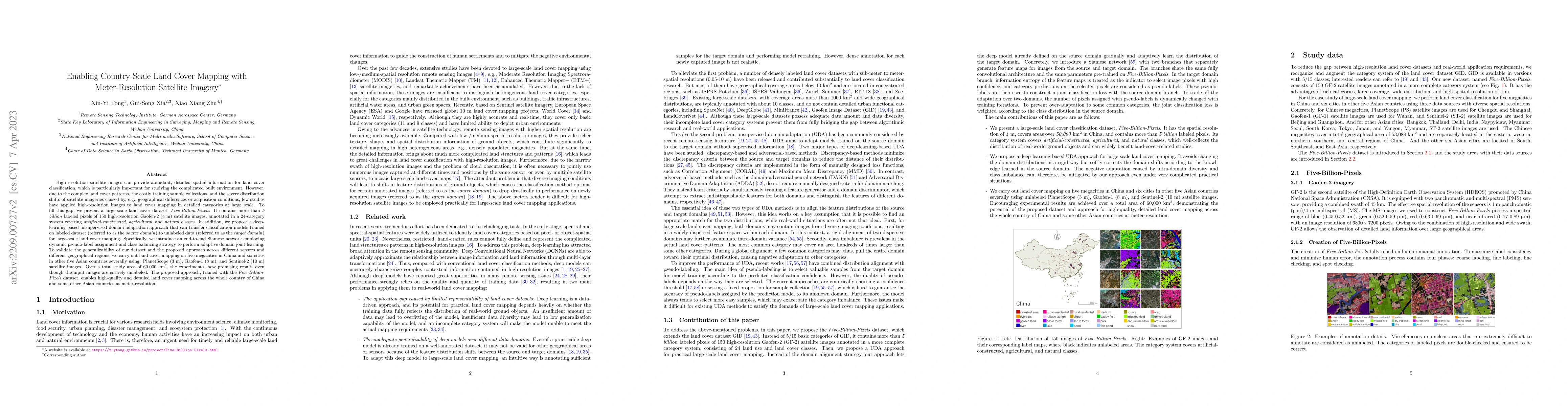
High-resolution satellite images can provide abundant, detailed spatial information for land cover classification, which is particularly important for studying the complicated built environment. However, due to the complex land cover patterns, the costly training sample collections, and the severe distribution shifts of satellite imageries, few studies have applied high-resolution images to land cover mapping in detailed categories at large scale. To fill this gap, we present a large-scale land cover dataset, Five-Billion-Pixels. It contains more than 5 billion labeled pixels of 150 high-resolution Gaofen-2 (4 m) satellite images, annotated in a 24-category system covering artificial-constructed, agricultural, and natural classes. In addition, we propose a deep-learning-based unsupervised domain adaptation approach that can transfer classification models trained on labeled dataset (referred to as the source domain) to unlabeled data (referred to as the target domain) for large-scale land cover mapping. Specifically, we introduce an end-to-end Siamese network employing dynamic pseudo-label assignment and class balancing strategy to perform adaptive domain joint learning. To validate the generalizability of our dataset and the proposed approach across different sensors and different geographical regions, we carry out land cover mapping on five megacities in China and six cities in other five Asian countries severally using: PlanetScope (3 m), Gaofen-1 (8 m), and Sentinel-2 (10 m) satellite images. Over a total study area of 60,000 square kilometers, the experiments show promising results even though the input images are entirely unlabeled. The proposed approach, trained with the Five-Billion-Pixels dataset, enables high-quality and detailed land cover mapping across the whole country of China and some other Asian countries at meter-resolution.
Seven facets of this paper, analysed and brought into focus by AI.
This research contributes to the development of reliable and efficient land cover mapping methods for large-scale applications.
This research uses a deep learning-based approach to automate land cover mapping from high-resolution satellite images.
This research contributes to the development of reliable and efficient land cover mapping methods for large-scale applications.
The proposed UDA approach is a novel contribution to the field of land cover mapping, leveraging deep learning techniques for accurate classification.
This research presents a new method for automating land cover mapping from high-resolution satellite images, which has significant implications for large-scale applications.
Current paper (gray), citations (green), references (blue)
Display is limited for performance on very large graphs.
Discussion 0