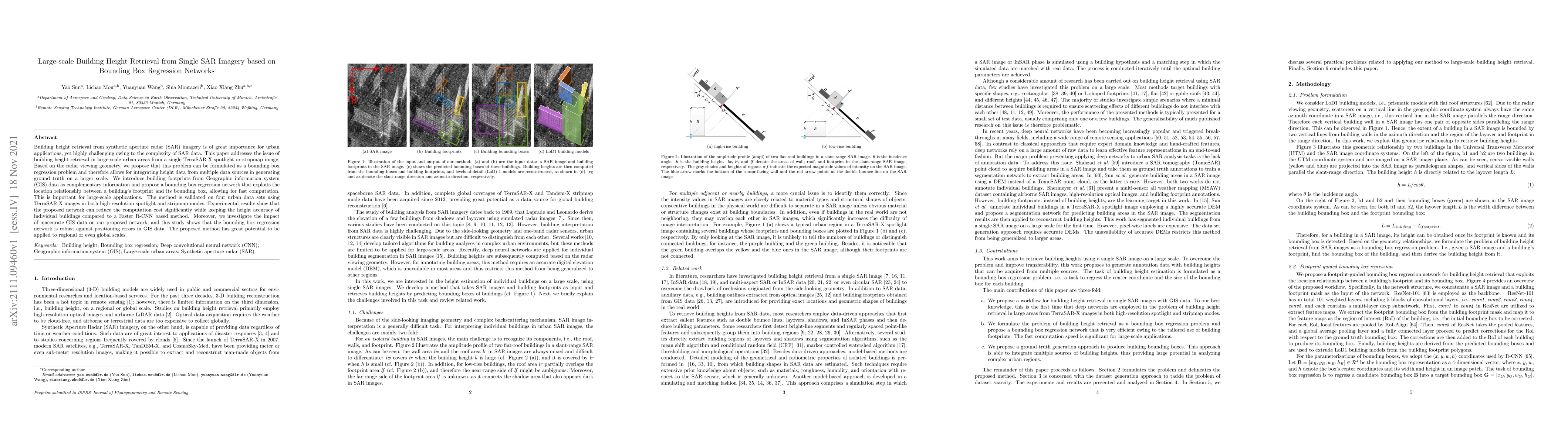
Building height retrieval from synthetic aperture radar (SAR) imagery is of great importance for urban applications, yet highly challenging owing to the complexity of SAR data. This paper addresses the issue of building height retrieval in large-scale urban areas from a single TerraSAR-X spotlight or stripmap image. Based on the radar viewing geometry, we propose that this problem can be formulated as a bounding box regression problem and therefore allows for integrating height data from multiple data sources in generating ground truth on a larger scale. We introduce building footprints from geographic information system (GIS) data as complementary information and propose a bounding box regression network that exploits the location relationship between a building's footprint and its bounding box, allowing for fast computation. This is important for large-scale applications. The method is validated on four urban data sets using TerraSAR-X images in both high-resolution spotlight and stripmap modes. Experimental results show that the proposed network can reduce the computation cost significantly while keeping the height accuracy of individual buildings compared to a Faster R-CNN based method. Moreover, we investigate the impact of inaccurate GIS data on our proposed network, and this study shows that the bounding box regression network is robust against positioning errors in GIS data. The proposed method has great potential to be applied to regional or even global scales.
Get AI-generated insights about this paper's methodology, results, and significance.
Current paper (gray), citations (green), references (blue)
Murtaza Taj, Mahd Qureshi, Shayaan Chaudhry et al.
Omar Abdelaziz, Mohamed Sami Shehata
Yong Xu, Siliang Ma
Title | Authors | Year | Actions |
---|---|---|---|
LoGAN: A novel local attentive generative adversarial resizable network for detailed 3D reconstruction of the Martian surface using monocular HiRISE images and DTMs
|
Jiarui Cao, Rong Huang, Yusheng Xu, Zhen Ye, Jia Qian, L. Hoegner, Xiaohua Tong
|
2025
|
View Paper |
Building Floor Number Estimation from Crowdsourced Street-Level Images: Munich Dataset and Baseline Method
|
Yao Sun, Sining Chen, Yifan Tian, Xiao Xiang Zhu
|
2025
|
View Paper |
Multi-angle analysis of shading-based modelling: extracting the urban building height based on ZY-3 three-line-array camera
|
Siqi Lu, Heli Lu, Yi Chen, Chuanrong Zhang, Changhong Miao
|
2025
|
View Paper |
Unveiling the performance and influential factors of GEDI L2A for building height retrieval
|
Peimin Chen, Huabing Huang, Peng Qin, Zhenbang Wu, Zixuan Wang, Chong Liu, Na Dong, Jie Wang
|
2025
|
View Paper |
The interannual variations of installed capacity for offshore wind turbines in China: estimations derived solely from remote sensing
|
Qiannan Ding, C. Chen, Bo Tian, Wenxiang Ji, Bin Zhang, Xue Li, Qing Yuan
|
2025
|
View Paper |
Towards High-Resolution Population Mapping: Leveraging Open Data, Remote Sensing, and AI for Geospatial Analysis in Developing Country Cities—A Case Study of Bangkok
|
Kittisak Maneepong, Ryota Yamanotera, Yuki Akiyama, Hiroyuki Miyazaki, Satoshi Miyazawa, Chiaki Mizutani Akiyama
|
2025
|
View Paper |
How geospatial technologies are transforming urban net-zero energy buildings: a comprehensive review of insights, challenges, and future directions
|
Yang Li, Haibo Feng
|
2025
|
View Paper |
Derivation of surface models using satellite imagery deep learning architectures with explainable AI
|
Vivaldi Rinaldi, Francisco Gómez-Vela, Masoud Ghandehari
|
2024
|
View Paper |
Fusion of Ascending and Descending Lutan-1 for Building Extraction in decision level
|
Ji Cheng, Mengke Jiang, Jie Ge, Yu Lei, Li Deng
|
2024
|
View Paper |
Building Height Estimation Using Shadow Length in Satellite Imagery
|
Mahd Qureshi, Shayaan Chaudhry, Sana Jabba, Murtaza Taj
|
2024
|
View Paper |
Urban Flood Mapping Using Satellite Synthetic Aperture Radar Data: A review of characteristics, approaches, and datasets
|
Jie Zhao, Ming Li, Yu Li, P. Matgen, M. Chini
|
2024
|
View Paper |
High-resolution population mapping based on SDGSAT-1 glimmer imagery and deep learning: a case study of the Guangdong-Hong Kong-Marco Greater Bay Area
|
Haoxuan Duan, Zhongqi Shi, J. Ge, Fan Wu, Yuzhou Liu, Hong Zhang, Chao Wang
|
2024
|
View Paper |
HENet: A Height Estimation Network for Estimating the Height of Buildings from Single Optical Image
|
Yachen Wang, Huayong Tang, Yejian Zhou, Guanyong Wang
|
2024
|
View Paper |
A learner behavior recognition and detection method based on human posture estimation
|
Fu Chen
|
2024
|
View Paper |
Learning Building Floor Numbers from Crowdsourced Streetview Images
|
Yifan Tian, Yao Sun, Xiao Xiang Zhu
|
2024
|
View Paper |
Inferring building height from footprint morphology data
|
Clinton Stipek, Taylor Hauser, Daniel S. Adams, Justin Epting, Christa Brelsford, J. Moehl, Philipe Dias, Jesse Piburn, Robert Stewart
|
2024
|
View Paper |
Post-Earthquake SAR-Optical Dataset for Quick Damaged-Building Detection
|
Yao Sun, Yi Wang, M. Eineder
|
2024
|
View Paper |
Predicting building characteristics at urban scale using graph neural networks and street-level context
|
Binyu Lei, Pengyuan Liu, Nikola Milojevic-Dupont, Filip Biljecki
|
2024
|
View Paper |
Refining urban morphology: An explainable machine learning method for estimating footprint-level building height
|
Yang Chen, Wen-Bin Sun, Ling Yang, Xin Yang, Xingyu Zhou, Xin Li, Sijin Li, Guoan Tang
|
2024
|
View Paper |
CMAR-Net: Accurate Cross-Modal 3D SAR Reconstruction of Vehicle Targets with Sparse-Aspect Multi-Baseline Data
|
Da Li, Guoqiang Zhao, Chen Yao, Kaiqiang Zhu, Houjun Sun, Jiacheng Bao
|
2024
|
View Paper |
Multi-feature supported dam height measurement method for large hydraulic projects using high resolution remote sensing imagery
|
Runsheng Ma, Yating Wei, Qiang Zhao, Shuangming Zhao, Zhiwen Yang, Shangguan Fang, Jixuan Li, Zhaowen Wu, Zhijuan Shen, Wen Zhang, Linyi Li, Lingkui Meng
|
2024
|
View Paper |
The SAR2Height framework for urban height map reconstruction from single SAR intensity images
|
M. Recla, Michael Schmitt
|
2024
|
View Paper |
Hyper‐Local Temperature Prediction Using Detailed Urban Climate Informatics
|
Peiyuan Li, Ashish Sharma
|
2024
|
View Paper |
Four seasonal composite Sentinel-2 images for the large-scale estimation of the number of stories in each individual building
|
Siqing Lyu, Chao Ji, Zeping Liu, Hong Tang, Liqiang Zhang, Xin Yang
|
2024
|
View Paper |
Three-dimensional lookup table for more precise SAR scatterers positioning in urban scenarios
|
Chisheng Wang, Mingxuan Wei, Xiaoqiong Qin, Tao Li, Shuo Chen, Chuanhua Zhu, Peng Liu, Ling Chang
|
2024
|
View Paper |
Exploiting SAR Visual Semantics in TomoSAR for 3D Modeling of Buildings
|
Wei Wang, Haixia Wang, Liankun Yu, Qiulei Dong, Zhanyi Hu
|
2024
|
View Paper |
A*–Ant Colony Optimization Algorithm for Multi-Branch Wire Harness Layout Planning
|
Feng Yang, Ping Wang, Renjie Zhang, Shuyu Xing, Zhenlin Wang, Ming Li, Qiang Fang
|
2024
|
View Paper |
Automated Building Height Estimation Using Ice, Cloud, and Land Elevation Satellite 2 Light Detection and Ranging Data and Building Footprints
|
Panli Cai, Jingxian Guo, Runkui Li, Zhen Xiao, Haiyu Fu, Tongze Guo, Xiaoping Zhang, Yashuai Li, Xianfeng Song
|
2024
|
View Paper |
QuickQuakeBuildings: Post-Earthquake SAR-Optical Dataset for Quick Damaged-Building Detection
|
Yao Sun, Yi Wang, M. Eineder
|
2023
|
View Paper |
Leveraging Chinese GaoFen-7 imagery for high-resolution building height estimation in multiple cities
|
Peimin Chen, Huabing Huang, Jinying Liu, Jie Wang, C. Liu, Ning Zhang, Mo Su, Dongjie Zhang
|
2023
|
View Paper |
HTC-DC Net: Monocular Height Estimation From Single Remote Sensing Images
|
Sining Chen, Yilei Shi, Zhitong Xiong, Xiaoxiang Zhu
|
2023
|
View Paper |
Towards Large-scale Building Attribute Mapping using Crowdsourced Images: Scene Text Recognition on Flickr and Problems to be Solved
|
Y. Sun, A. Kruspe, L. Meng, Y. Tian, E. J. Hoffmann, S. Auer, X. X. Zhu
|
2023
|
View Paper |
Satellite-Based Identification and Characterization of Extreme Ice Features: Hummocks and Ice Islands
|
I. Zakharov, P. Bobby, D. Power, S. Warren, Mark Howell
|
2023
|
View Paper |
Utilizing Building Offset and Shadow to Retrieve Urban Building Heights with ICESat-2 Photons
|
Bin Wu, Hailan Huang, Yi Zhao
|
2023
|
View Paper |
PolyGNN: Polyhedron-based Graph Neural Network for 3D Building Reconstruction from Point Clouds
|
Zhaiyu Chen, Yilei Shi, L. Nan, Zhitong Xiong, Xiao Xiang Zhu
|
2023
|
View Paper |
Mapping local climate zones for cities: A large review
|
F. Huang, Sida Jiang, W. Zhan, B. Bechtel, Zihan Liu, M. Demuzere, Yuan Huang, Yong Xu, L. Ma, Wanjun Xia, Jinling Quan, Lu-lu Jiang, Jiameng Lai, Chenguang Wang, Fanhua Kong, Huilin Du, Shiqi Miao, Yangyi Chen, Jike Chen
|
2023
|
View Paper |
Semi-supervised segmentation of individual buildings from SAR imagery
|
Qingyu Li, Yao Sun, Lichao Mou, Yilei Shi, Xiao Xiang Zhu
|
2023
|
View Paper |
Combining ICESat-2 photons and Google Earth Satellite images for building height extraction
|
Yi Zhao, Bin Wu, Qiaoxuan Li, Lei Yang, H. Fan, Jianping Wu, Bailang Yu
|
2023
|
View Paper |
Estimation of urban-scale photovoltaic potential: A deep learning-based approach for constructing three-dimensional building models from optical remote sensing imagery imagery
|
Longxu Yan, R. Zhu, Mei‐Po Kwan, Wei Luo, De Wang, Shangwu Zhang, Man Sing Wong, Linlin You, Bishen Yang, Biyu Chen, Ling Feng
|
2023
|
View Paper |
Automatic building height estimation with shadow correction over heterogeneous compact cities using stereo Gaofen-7 data at sub-meter resolution
|
R. Liu, Hongsheng Zhang, Ka Hei Anson Yip, Jing Ling, Yinyi Lin, Huabing Huang
|
2023
|
View Paper |
SHAFTS (v2022.3): a deep-learning-based Python package for simultaneous extraction of building height and footprint from sentinel imagery
|
Ruidong Li, Ting Sun, Fuqiang Tian, G. Ni
|
2023
|
View Paper |
Convolutional Attention-enabled Underwater Object Detection with Electro-optical Image
|
Tao Yin, Xiantao Jiang, Hongbin Xu
|
2022
|
View Paper |
Stereollax Net: Stereo Parallax-Based Deep Learning Network for Building Height Estimation
|
Sana Jabbar, Murtaza Taj
|
2024
|
View Paper |
Extracting Building Footprints in SAR Images via Distilling Boundary Information From Optical Images
|
Yuxuan Wang, Lanxin Zeng, Wen Yang, Jian Kang, Huai Yu, Mihai Datcu, Gui-Song Xia
|
2024
|
View Paper |
A Review of Building Extraction From Remote Sensing Imagery: Geometrical Structures and Semantic Attributes
|
Qingyu Li, Lichao Mou, Yao Sun, Yuansheng Hua, Yilei Shi, Xiao Xiang Zhu
|
2024
|
View Paper |
Building Height Extraction From High-Resolution Single-View Remote Sensing Images Using Shadow and Side Information
|
Wanqi Xu, Zhangyin Feng, Qian Wan, Yakun Xie, Dejun Feng, Jun Zhu, Yangge Liu
|
2024
|
View Paper |
Self-Supervised Pretraining With Monocular Height Estimation for Semantic Segmentation
|
Zhitong Xiong, Sining Chen, Yilei Shi, Xiao Xiang Zhu
|
2024
|
View Paper |
A Two-Step Ensemble-Based Genetic Algorithm for Land Cover Classification
|
Yang Cao, W. Feng, Y. Quan, Wenxing Bao, G. Dauphin, Yijia Song, A. Ren, M. Xing
|
2023
|
View Paper |
An Algorithm Measuring Urban Building Heights by Combining the PS-InSAR Technique and Two-Stage Programming Approach Framework
|
Bao Zhu, Yong F. Wang, Hanwen Yu
|
2023
|
View Paper |
SAR True Digital Ortho Map Production for Target Geometric Structure Preservation
|
Niangang Jiao, Feng Wang, Yuxin Hu, Yuming Xiang, Rui Liu, H. You
|
2023
|
View Paper |
CMAR-Net: Accurate Cross-Modal 3D SAR Reconstruction of Vehicle Targets with Sparse Multi-Baseline Data
|
Da Li, Guoqiang Zhao, Houjun Sun, Jiacheng Bao
|
View Paper |
Comments (0)