Quick Summary:

SHAZAM is a self-supervised change monitoring system that leverages a lightweight conditional UNet to detect and map environmental hazards by modeling normal seasonal changes and distinguishing anomalies. It achieved significant F1 score improvements over existing methods, demonstrating superior hazard detection and mapping capabilities with high spatial resolution.

Summary

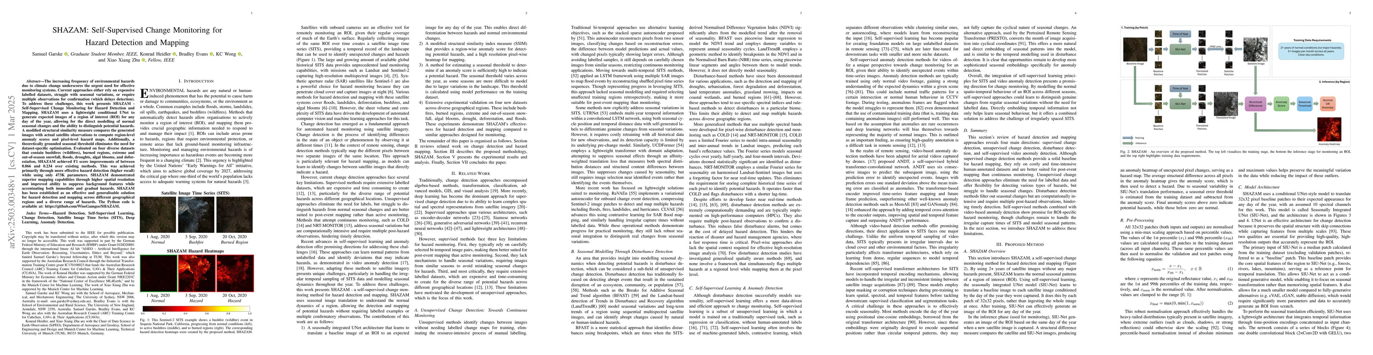
The increasing frequency of environmental hazards due to climate change underscores the urgent need for effective monitoring systems. Current approaches either rely on expensive labelled datasets, struggle with seasonal variations, or require multiple observations for confirmation (which delays detection). To address these challenges, this work presents SHAZAM - Self-Supervised Change Monitoring for Hazard Detection and Mapping. SHAZAM uses a lightweight conditional UNet to generate expected images of a region of interest (ROI) for any day of the year, allowing for the direct modelling of normal seasonal changes and the ability to distinguish potential hazards. A modified structural similarity measure compares the generated images with actual satellite observations to compute region-level anomaly scores and pixel-level hazard maps. Additionally, a theoretically grounded seasonal threshold eliminates the need for dataset-specific optimisation. Evaluated on four diverse datasets that contain bushfires (wildfires), burned regions, extreme and out-of-season snowfall, floods, droughts, algal blooms, and deforestation, SHAZAM achieved F1 score improvements of between 0.066 and 0.234 over existing methods. This was achieved primarily through more effective hazard detection (higher recall) while using only 473K parameters. SHAZAM demonstrated superior mapping capabilities through higher spatial resolution and improved ability to suppress background features while accentuating both immediate and gradual hazards. SHAZAM has been established as an effective and generalisable solution for hazard detection and mapping across different geographical regions and a diverse range of hazards. The Python code is available at: https://github.com/WiseGamgee/SHAZAM

AI Key Findings

Generated Jun 10, 2025

Methodology

SHAZAM uses a lightweight conditional UNet to generate expected images of a region of interest (ROI) for any day of the year, modelling normal seasonal changes and distinguishing potential hazards. It employs a modified structural similarity measure to compare generated images with actual satellite observations, computing region-level anomaly scores and pixel-level hazard maps. A theoretically grounded seasonal threshold eliminates the need for dataset-specific optimization.

Key Results

  • SHAZAM achieved F1 score improvements of between 0.066 and 0.234 over existing methods on four diverse datasets.
  • Superior hazard detection (higher recall) was achieved while using only 473K parameters.
  • Demonstrated superior mapping capabilities through higher spatial resolution and improved ability to suppress background features while accentuating both immediate and gradual hazards.

Significance

This research presents an effective and generalizable solution for hazard detection and mapping across different geographical regions and a diverse range of hazards, addressing the urgent need for efficient monitoring systems in the face of increasing environmental hazards due to climate change.

Technical Contribution

SHAZAM introduces a self-supervised change monitoring approach for hazard detection and mapping, integrating seasonal modelling, structural difference mapping, and a seasonally adaptive threshold, all while being extremely lightweight with the least number of learnable parameters.

Novelty

SHAZAM's novelty lies in its self-supervised learning, seasonal modelling, and adaptive thresholding approach, which effectively balances false alarms and missed hazard detections across diverse geographical regions and hazard types.

Limitations

  • The current evaluation uses datasets with less than 10% cloud cover, which limits the management of cloud coverage.
  • Does not capture gradual changes driven by longer-term weather patterns (e.g., El Nino and La Nina).

Future Work

  • Explore solutions for managing cloud coverage, such as using SAR images or recent generative methods converting SAR to multispectral images.
  • Investigate modelling longer-term weather patterns and trends, potentially integrating multi-modal approaches with additional data sources.

Paper Details

PDF Preview

Download PDF

Key Terms

No key terms available for this paper.

No citations found for this paper.

Comments (0)

This website uses cookies to ensure you get the best experience. Learn more