Global High Categorical Resolution Land Cover Mapping via Weak Supervision
Publication
Metrics
AI Quick Summary
This paper proposes a Prototype-based pseudo-labeling method for high categorical resolution land cover mapping using weakly supervised domain adaptation. The approach leverages sparse and coarse weak labels to reduce the need for detailed annotations, achieving over 80% accuracy in cross-sensor, cross-category, and cross-continent studies for 10 global cities.
Paper Preview
Abstract
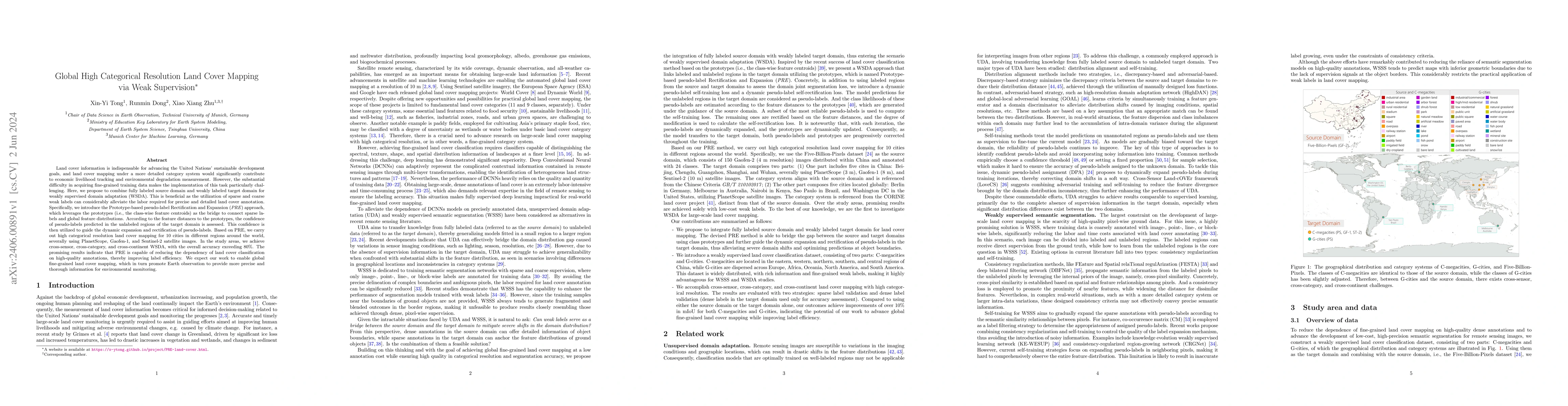
Land cover information is indispensable for advancing the United Nations' sustainable development goals, and land cover mapping under a more detailed category system would significantly contribute to economic livelihood tracking and environmental degradation measurement. However, the substantial difficulty in acquiring fine-grained training data makes the implementation of this task particularly challenging. Here, we propose to combine fully labeled source domain and weakly labeled target domain for weakly supervised domain adaptation (WSDA). This is beneficial as the utilization of sparse and coarse weak labels can considerably alleviate the labor required for precise and detailed land cover annotation. Specifically, we introduce the Prototype-based pseudo-label Rectification and Expansion (PRE) approach, which leverages the prototypes (i.e., the class-wise feature centroids) as the bridge to connect sparse labels and global feature distributions. According to the feature distances to the prototypes, the confidence of pseudo-labels predicted in the unlabeled regions of the target domain is assessed. This confidence is then utilized to guide the dynamic expansion and rectification of pseudo-labels. Based on PRE, we carry out high categorical resolution land cover mapping for 10 cities in different regions around the world, severally using PlanetScope, Gaofen-1, and Sentinel-2 satellite images. In the study areas, we achieve cross-sensor, cross-category, and cross-continent WSDA, with the overall accuracy exceeding 80%. The promising results indicate that PRE is capable of reducing the dependency of land cover classification on high-quality annotations, thereby improving label efficiency. We expect our work to enable global fine-grained land cover mapping, which in turn promote Earth observation to provide more precise and thorough information for environmental monitoring.
AI Key Findings
Get AI-generated insights about this paper's methodology, results, significance, and more — seven facets brought into focus.
Impact
Paper Details
Authors
PDF Preview
Key Terms
Citation Network
Current paper (gray), citations (green), references (blue)
Display is limited for performance on very large graphs.
Discussion 0