ArxivLens

Publication

Published: Oct 02, 2025
Categories: stat.ME

Metrics

Source: ArXiv

Quick Answers

What methodology did the authors use?

The study employs a Bayesian hierarchical modeling framework to analyze spatially dependent peaks-over-threshold data, integrating temporal and spatial covariates to improve extreme event prediction. More in Methodology →

What are the key results?

The D4-M5 model demonstrated superior performance in estimating precipitation return levels across multiple return periods. — Incorporating covariates such as elevation and land use significantly improved model accuracy for extreme precipitation events. More in Key Results →

Why is this work significant?

This research advances spatial extreme value analysis by offering a flexible framework for modeling complex dependencies in environmental data, with direct applications for climate risk assessment and disaster preparedness. More in Significance →

What are the main limitations?

Model performance is constrained by the quality and density of observational data in certain regions. — Computational complexity limits the scalability of the approach for very large spatial domains. More in Limitations →

Paper Preview

Abstract

We develop a Bayesian spatio-temporal framework for extreme-value analysis that augments a hierarchical copula model with an autoregressive factor to capture residual temporal dependence in threshold exceedances. The factor can be specified as spatially varying or spatially constant, and the scale parameter incorporates scientifically relevant covariates (e.g., longitude, latitude, altitude), enabling flexible representation of geographic heterogeneity. To avoid the computational burden of the full censored 
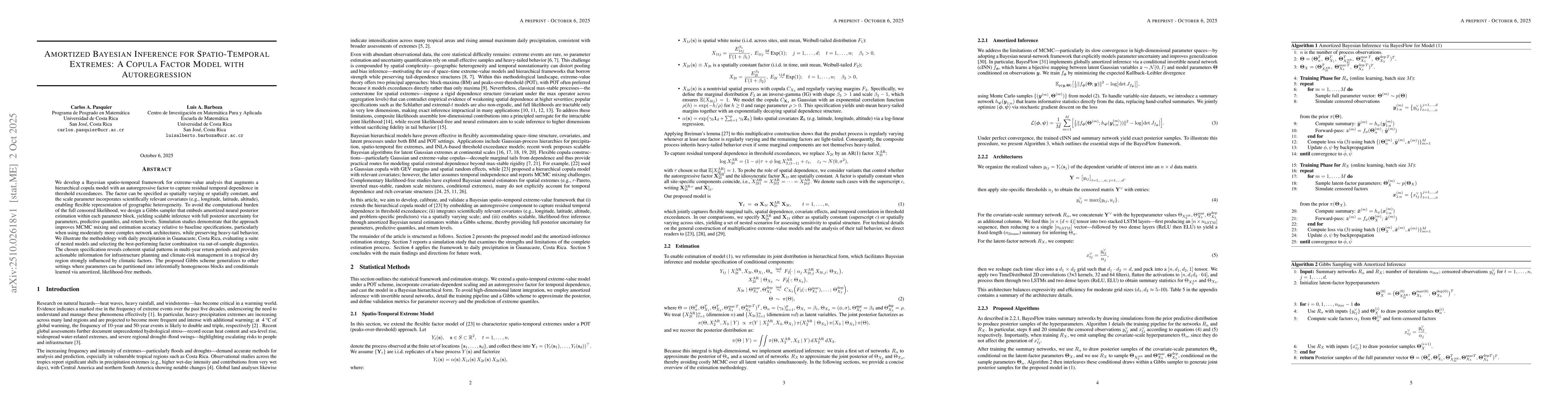
likelihood, we design a Gibbs sampler that embeds amortized neural posterior estimation within each parameter block, yielding scalable inference with full posterior uncertainty for parameters, predictive quantiles, and return levels. Simulation studies demonstrate that the approach improves MCMC mixing and estimation accuracy relative to baseline specifications, particularly when using moderately more complex network architectures, while preserving heavy-tail behavior. We illustrate the methodology with daily precipitation in Guanacaste, Costa Rica, evaluating a suite of nested models and selecting the best-performing factor combination via out-of-sample diagnostics. The chosen specification reveals coherent spatial patterns in multi-year return periods and provides actionable information for infrastructure planning and climate-risk management in a tropical dry region strongly influenced by climatic factors. The proposed Gibbs scheme generalizes to other settings where parameters can be partitioned into inferentially homogeneous blocks and conditionals learned via amortized, likelihood-free methods.

Key Findings, in focus

Seven facets of this paper, analysed and brought into focus by AI.

AI-generated · verify against source Generated Oct 12, 2025
In focus · one-line synthesis

This research advances spatial extreme value analysis by offering a flexible framework for modeling complex dependencies in environmental data, with direct applications for climate risk assessment and disaster preparedness.

01
MethodologyHow they did it

The study employs a Bayesian hierarchical modeling framework to analyze spatially dependent peaks-over-threshold data, integrating temporal and spatial covariates to improve extreme event prediction.

02
ResultsWhat they found
  • The D4-M5 model demonstrated superior performance in estimating precipitation return levels across multiple return periods.
  • Incorporating covariates such as elevation and land use significantly improved model accuracy for extreme precipitation events.
  • The model effectively captured spatial dependencies, providing reliable quantile estimates for regions with sparse observational data.
03
SignificanceWhy it matters

This research advances spatial extreme value analysis by offering a flexible framework for modeling complex dependencies in environmental data, with direct applications for climate risk assessment and disaster preparedness.

04
Technical ContributionsWhat's new technically

Development of an amortized Bayesian inference approach using neural networks for efficient parameter estimation in complex spatial extreme value models.

05
NoveltyWhat sets it apart

Combines hierarchical Bayesian modeling with neural networks for spatial extremes, enabling scalable and flexible inference while maintaining rigorous statistical properties.

06
LimitationsWhat to be cautious about
  • Model performance is constrained by the quality and density of observational data in certain regions.
  • Computational complexity limits the scalability of the approach for very large spatial domains.
07
Future WorkWhere it goes next
  • Exploring machine learning integration for real-time extreme event prediction.
  • Extending the framework to incorporate non-stationary climate patterns and climate change projections.

Paper Details

Paper ID: 2510.02618
Categories:
stat.ME

How to Cite This Paper

Reference manager: RIS EndNote


Discussion 0

This website uses cookies to ensure you get the best experience. Learn more