Assessment of Sentinel-2 spatial and temporal coverage based on the scene classification layer
Publication
Metrics
AI Quick Summary
This paper proposes a method to evaluate Sentinel-2 satellite imagery's spatial and temporal coverage using the scene classification layer, showing that regions with higher coverage yield better machine learning model predictions. The technique was tested on the AI4EO challenge and applied globally across LandCoverNet.
Paper Preview
Abstract
Since the launch of the Sentinel-2 (S2) satellites, many ML models have used the data for diverse applications. The scene classification layer (SCL) inside the S2 product provides rich information for training, such as filtering images with high cloud coverage. However, there is more potential in this. We propose a technique to assess the clean optical coverage of a region, expressed by a SITS and calculated with the S2-based SCL data. With a manual threshold and specific labels in the SCL, the proposed technique assigns a percentage of spatial and temporal coverage across the time series and a high/low assessment. By evaluating the AI4EO challenge for Enhanced Agriculture, we show that the assessment is correlated to the predictive results of ML models. The classification results in a region with low spatial and temporal coverage is worse than in a region with high coverage. Finally, we applied the technique across all continents of the global dataset LandCoverNet.
AI Key Findings
Get AI-generated insights about this paper's methodology, results, significance, and more — seven facets brought into focus.
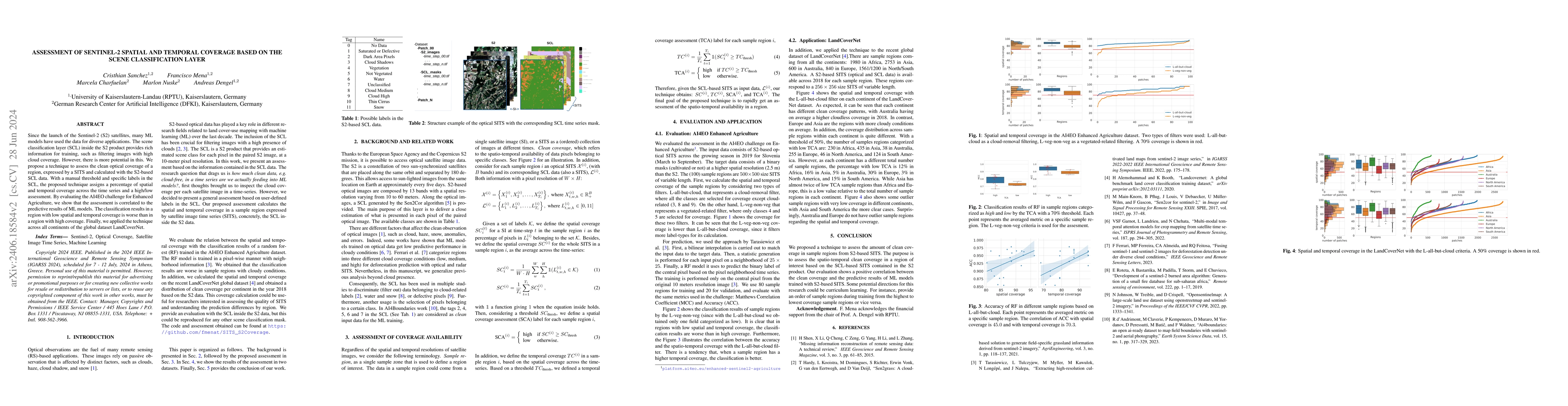
Impact
Authors
PDF Preview
Key Terms
Citation Network
Current paper (gray), citations (green), references (blue)
Display is limited for performance on very large graphs.
Discussion 0