ArxivLens

Publication

Published: Sep 06, 2025
Categories: cs.HC

Metrics

Source: ArXiv

Quick Answers

What methodology did the authors use?

The research employs a human-centered computing approach with two plug-and-play NLP pipelines: a context-aware text labeling model for detecting racially restrictive language and a georeferencing module for extracting geographic descriptions from deeds. More in Methodology →

What are the key results?

The system reduces false positives in racial term detection by 25.96% while maintaining 91.73% recall — Achieves 85.58% georeferencing accuracy within 1x1 square-mile ranges More in Key Results →

Why is this work significant?

This research addresses historical racial inequalities by improving the detection and mapping of racial covenants, supporting social change and public engagement through technology. More in Significance →

What are the main limitations?

Current pipelines may miss implicit restrictive clauses — Georeferencing accuracy varies with document complexity and OCR errors More in Limitations →

Paper Preview

Abstract

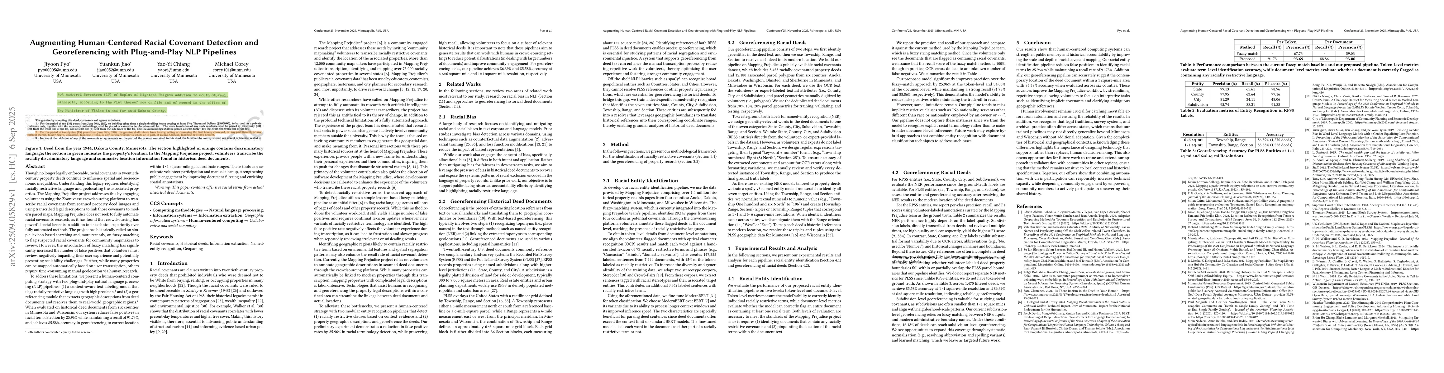
Though no longer legally enforceable, racial covenants in twentieth-century property deeds continue to shape spatial and socioeconomic inequalities. Understanding this legacy requires identifying racially restrictive language and geolocating affected properties. The Mapping Prejudice project addresses this by engaging volunteers on the Zooniverse crowdsourcing platform to transcribe covenants from scanned deeds and link them to modern parcel maps using transcribed legal descriptions. While the project has explored automation, it values crowdsourcing for its social impact and technical advantages. Historically, Mapping Prejudice relied on lexicon-based searching and, more recently, fuzzy matching to flag suspected covenants. However, fuzzy matching has increased false positives, burdening volunteers and raising scalability concerns. Additionally, while many properties can be mapped automatically, others still require time-intensive manual geolocation. We present a human-centered computing approach with two plug-and-play NLP pipelines: (1) a context-aware text labeling model that flags racially restrictive language with high precision and (2) a georeferencing module that extracts geographic descriptions from deeds and resolves them to real-world locations. Evaluated on historical deed documents from six counties in Minnesota and Wisconsin, our system reduces false positives in racial term detection by 25.96% while maintaining 91.73% recall and achieves 85.58% georeferencing accuracy within 1x1 square-mile ranges. These tools enhance document filtering and enrich spatial annotations, accelerating volunteer participation and reducing manual cleanup while strengthening public engagement.

Key Findings, in focus

Seven facets of this paper, analysed and brought into focus by AI.

AI-generated · verify against source Generated Nov 19, 2025
In focus · one-line synthesis

This research addresses historical racial inequalities by improving the detection and mapping of racial covenants, supporting social change and public engagement through technology.

01
MethodologyHow they did it

The research employs a human-centered computing approach with two plug-and-play NLP pipelines: a context-aware text labeling model for detecting racially restrictive language and a georeferencing module for extracting geographic descriptions from deeds.

02
ResultsWhat they found
  • The system reduces false positives in racial term detection by 25.96% while maintaining 91.73% recall
  • Achieves 85.58% georeferencing accuracy within 1x1 square-mile ranges
  • Enhances document filtering and spatial annotations, accelerating volunteer participation
03
SignificanceWhy it matters

This research addresses historical racial inequalities by improving the detection and mapping of racial covenants, supporting social change and public engagement through technology.

04
Technical ContributionsWhat's new technically

Development of a context-aware NLP pipeline for racial term detection and a georeferencing module that resolves property descriptions to real-world locations

05
NoveltyWhat sets it apart

Integration of human-centered computing with NLP pipelines for scalable, accurate detection of racial covenants while maintaining volunteer engagement and reducing manual cleanup

06
LimitationsWhat to be cautious about
  • Current pipelines may miss implicit restrictive clauses
  • Georeferencing accuracy varies with document complexity and OCR errors
07
Future WorkWhere it goes next
  • Develop hybrid, two-stage approaches for better handling implicit clauses
  • Expand normalization and use transformer-based models for improved georeferencing

Paper Details

Paper ID: 2509.05829
Categories:
cs.HC

How to Cite This Paper

Reference manager: RIS EndNote

Related Papers

4 found


Discussion 0

This website uses cookies to ensure you get the best experience. Learn more