Automated GIS-Based Framework for Detecting Crosswalk Changes from Bi-Temporal High-Resolution Aerial Images
Publication
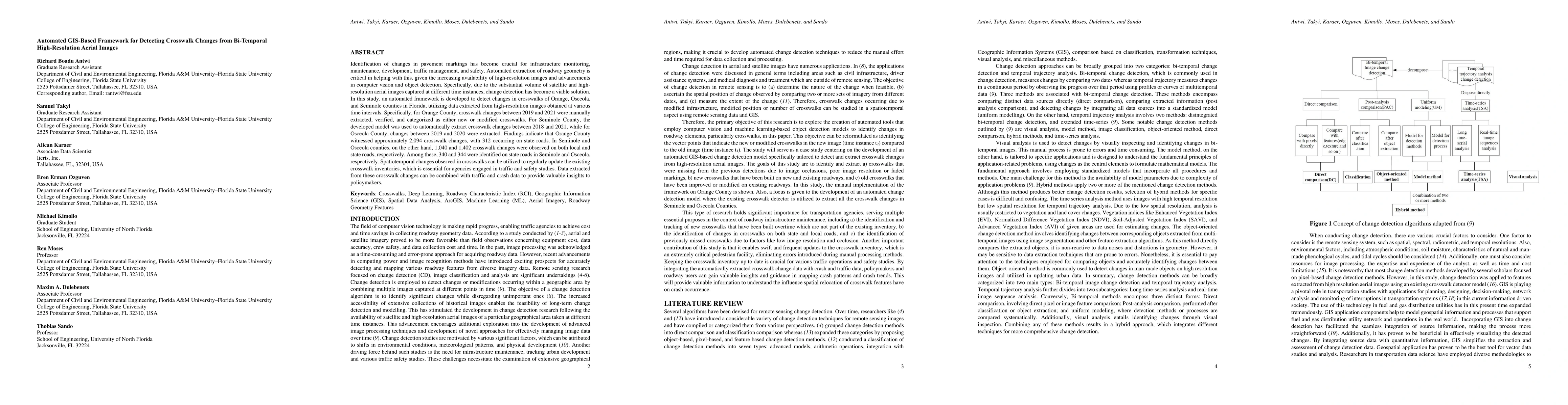
Metrics
AI Quick Summary
This research presents an automated GIS-based framework for detecting crosswalk changes from bi-temporal high-resolution aerial images in Florida. The study identifies significant crosswalk modifications in Orange, Osceola, and Seminole counties, demonstrating the utility of the framework in updating crosswalk inventories and informing traffic safety studies.
Paper Preview
Abstract
Identification of changes in pavement markings has become crucial for infrastructure monitoring, maintenance, development, traffic management, and safety. Automated extraction of roadway geometry is critical in helping with this, given the increasing availability of high-resolution images and advancements in computer vision and object detection. Specifically, due to the substantial volume of satellite and high-resolution aerial images captured at different time instances, change detection has become a viable solution. In this study, an automated framework is developed to detect changes in crosswalks of Orange, Osceola, and Seminole counties in Florida, utilizing data extracted from high-resolution images obtained at various time intervals. Specifically, for Orange County, crosswalk changes between 2019 and 2021 were manually extracted, verified, and categorized as either new or modified crosswalks. For Seminole County, the developed model was used to automatically extract crosswalk changes between 2018 and 2021, while for Osceola County, changes between 2019 and 2020 were extracted. Findings indicate that Orange County witnessed approximately 2,094 crosswalk changes, with 312 occurring on state roads. In Seminole and Osceola counties, on the other hand, 1,040 and 1,402 crosswalk changes were observed on both local and state roads, respectively. Among these, 340 and 344 were identified on state roads in Seminole and Osceola, respectively. Spatiotemporal changes observed in crosswalks can be utilized to regularly update the existing crosswalk inventories, which is essential for agencies engaged in traffic and safety studies. Data extracted from these crosswalk changes can be combined with traffic and crash data to provide valuable insights to policymakers.
AI Key Findings
Get AI-generated insights about this paper's methodology, results, significance, and more — seven facets brought into focus.
Impact
Paper Details
Authors
PDF Preview
Key Terms
Citation Network
Current paper (gray), citations (green), references (blue)
Display is limited for performance on very large graphs.
Discussion 0