The paper proposes an automated road extraction and centreline fitting approach using LiDAR point clouds. It involves statistical outlier removal, density-based clustering, ground point filtering with grid-based segmentation, 2D projection, skeletonisation, back-projection, and smoothing with Savitzky-Golay filter.
Automated Road Extraction and Centreline Fitting in LiDAR Point Clouds
Publication
Metrics
AI Quick Summary
This paper proposes a method for automated road extraction and centreline fitting from LiDAR point clouds using a top-down view, reducing reliance on specific kerb designs. It involves statistical outlier removal, density-based clustering, and a skeletonisation algorithm for road extraction, achieving a 73% Intersection over Union (IoU) on the Perth CBD dataset.
Quick Answers
What methodology did the authors use?
The paper proposes an automated road extraction and centreline fitting approach using LiDAR point clouds. It involves statistical outlier removal, density-based clustering, ground point filtering with grid-based segmentation, 2D projection, skeletonisation, back-projection, and smoothing with Savitzky-Golay filter. More in Methodology →
What are the key results?
The initial approach achieved 67% IoU on the Perth CBD dataset. — Post-processing of road skeleton improved IoU to 73%. More in Key Results →
Why is this work significant?
This research presents a significant improvement in road extraction from LiDAR point clouds, reducing reliance on specific kerb designs and performing well in high-density areas, which is crucial for urban planning and traffic management. More in Significance →
What are the main limitations?
The algorithm is sensitive to parameter settings, particularly grid size and RANSAC thresholds. — Extracted road framework in 2D format still contains some outliers affecting accuracy. More in Limitations →
Abstract
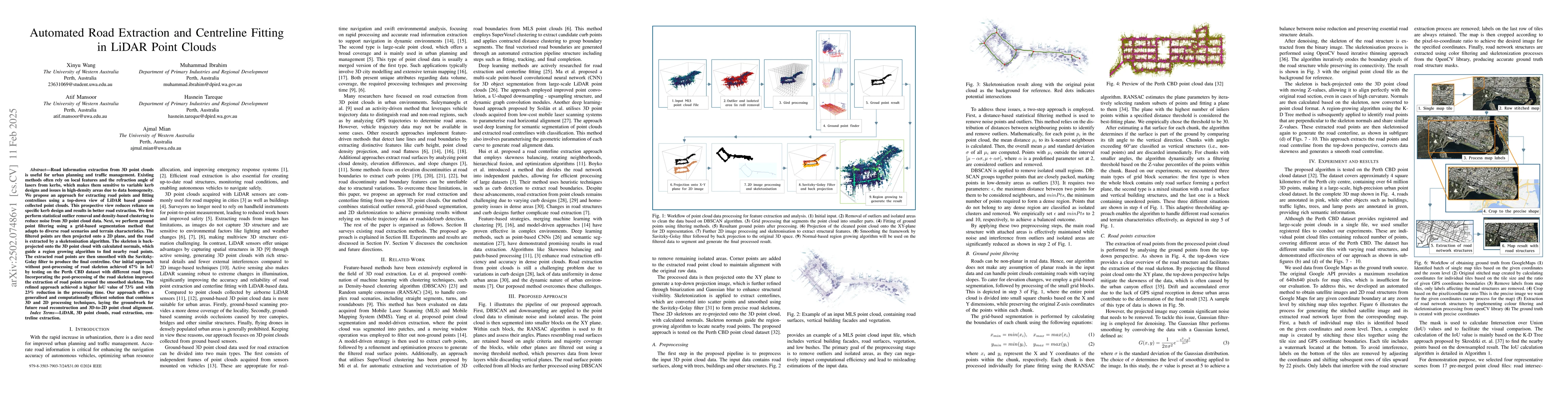
Road information extraction from 3D point clouds is useful for urban planning and traffic management. Existing methods often rely on local features and the refraction angle of lasers from kerbs, which makes them sensitive to variable kerb designs and issues in high-density areas due to data homogeneity. We propose an approach for extracting road points and fitting centrelines using a top-down view of LiDAR based ground-collected point clouds. This prospective view reduces reliance on specific kerb design and results in better road extraction. We first perform statistical outlier removal and density-based clustering to reduce noise from 3D point cloud data. Next, we perform ground point filtering using a grid-based segmentation method that adapts to diverse road scenarios and terrain characteristics. The filtered points are then projected onto a 2D plane, and the road is extracted by a skeletonisation algorithm. The skeleton is back-projected onto the 3D point cloud with calculated normals, which guide a region growing algorithm to find nearby road points. The extracted road points are then smoothed with the Savitzky-Golay filter to produce the final centreline. Our initial approach without post-processing of road skeleton achieved 67% in IoU by testing on the Perth CBD dataset with different road types. Incorporating the post-processing of the road skeleton improved the extraction of road points around the smoothed skeleton. The refined approach achieved a higher IoU value of 73% and with 23% reduction in the processing time. Our approach offers a generalised and computationally efficient solution that combines 3D and 2D processing techniques, laying the groundwork for future road reconstruction and 3D-to-2D point cloud alignment.
Key Findings, in focus
Seven facets of this paper, analysed and brought into focus by AI.
This research presents a significant improvement in road extraction from LiDAR point clouds, reducing reliance on specific kerb designs and performing well in high-density areas, which is crucial for urban planning and traffic management.
- The initial approach achieved 67% IoU on the Perth CBD dataset.
- Post-processing of road skeleton improved IoU to 73%.
- Processing time was reduced by 23% with the refined approach.
- The method offers a generalized and computationally efficient solution for road reconstruction and 3D-to-2D point cloud alignment.
This research presents a significant improvement in road extraction from LiDAR point clouds, reducing reliance on specific kerb designs and performing well in high-density areas, which is crucial for urban planning and traffic management.
The paper introduces a combined 3D-2D processing technique for road extraction and centreline fitting, utilizing a top-down strategy and normal vectors for region growing.
The proposed method reduces dependency on kerb designs and performs well in high-density areas, offering a more generalized and efficient solution compared to existing methods.
- The algorithm is sensitive to parameter settings, particularly grid size and RANSAC thresholds.
- Extracted road framework in 2D format still contains some outliers affecting accuracy.
- Separating open areas like carparks from extracted road points.
- Optimizing RANSAC parameters to adapt to different road scenarios.
- Refining region-growing algorithm to detect street directions and pedestrian pathway boundaries.
Impact
Paper Details
Authors
PDF Preview
Citation Network
Current paper (gray), citations (green), references (blue)
Display is limited for performance on very large graphs.
Discussion 0