Automatic Construction of a Large-Scale Corpus for Geoparsing Using Wikipedia Hyperlinks
Publication
Metrics
AI Quick Summary
This paper introduces WHLL, a method using Wikipedia hyperlinks to construct a large-scale geoparsing corpus, which comprises 1.3M articles with 7.8 unique location expressions per article, 45.6% of which are ambiguous. The method leverages hyperlinks to accurately annotate location coordinates, though room for improvement in disambiguating ambiguous locations remains.
Paper Preview
Abstract
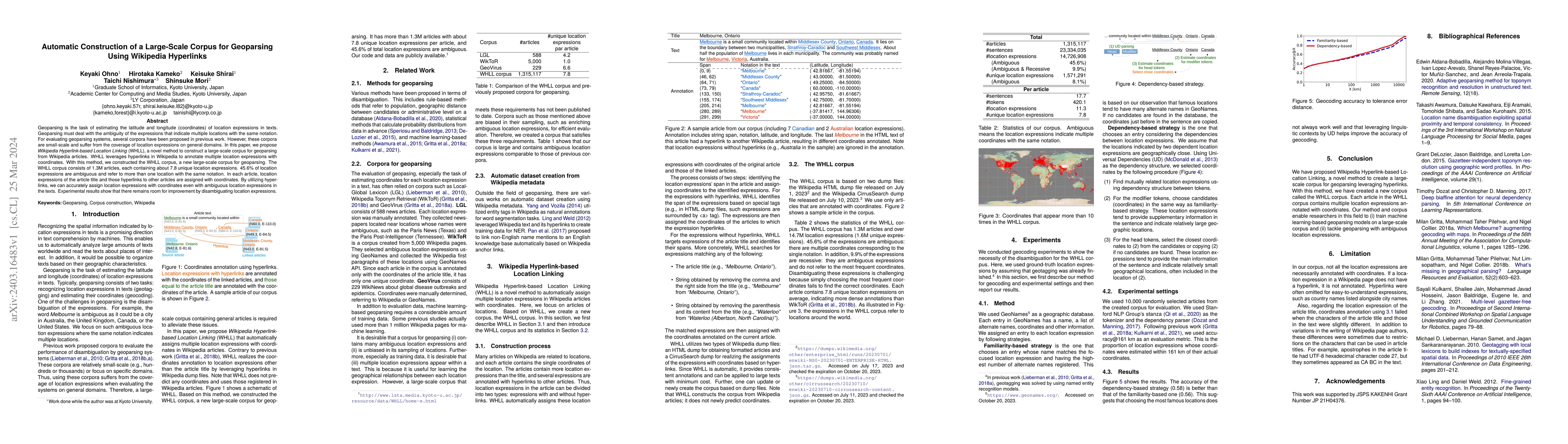
Geoparsing is the task of estimating the latitude and longitude (coordinates) of location expressions in texts. Geoparsing must deal with the ambiguity of the expressions that indicate multiple locations with the same notation. For evaluating geoparsing systems, several corpora have been proposed in previous work. However, these corpora are small-scale and suffer from the coverage of location expressions on general domains. In this paper, we propose Wikipedia Hyperlink-based Location Linking (WHLL), a novel method to construct a large-scale corpus for geoparsing from Wikipedia articles. WHLL leverages hyperlinks in Wikipedia to annotate multiple location expressions with coordinates. With this method, we constructed the WHLL corpus, a new large-scale corpus for geoparsing. The WHLL corpus consists of 1.3M articles, each containing about 7.8 unique location expressions. 45.6% of location expressions are ambiguous and refer to more than one location with the same notation. In each article, location expressions of the article title and those hyperlinks to other articles are assigned with coordinates. By utilizing hyperlinks, we can accurately assign location expressions with coordinates even with ambiguous location expressions in the texts. Experimental results show that there remains room for improvement by disambiguating location expressions.
AI Key Findings
Get AI-generated insights about this paper's methodology, results, significance, and more — seven facets brought into focus.
Impact
Paper Details
Authors
PDF Preview
Key Terms
Citation Network
Current paper (gray), citations (green), references (blue)
Display is limited for performance on very large graphs.
Discussion 0