Automatic Detection of Natural Disaster Effect on Paddy Field from Satellite Images using Deep Learning Techniques
Publication
Metrics
AI Quick Summary
This paper develops a deep learning model using high-resolution satellite imagery to detect rice field damage from natural disasters in Bangladesh. The study combines NDVI analysis and ground truth data from local farmers to identify crop loss areas, achieving better IoU scores with False Color Infrared bands compared to RGB.
Paper Preview
Abstract
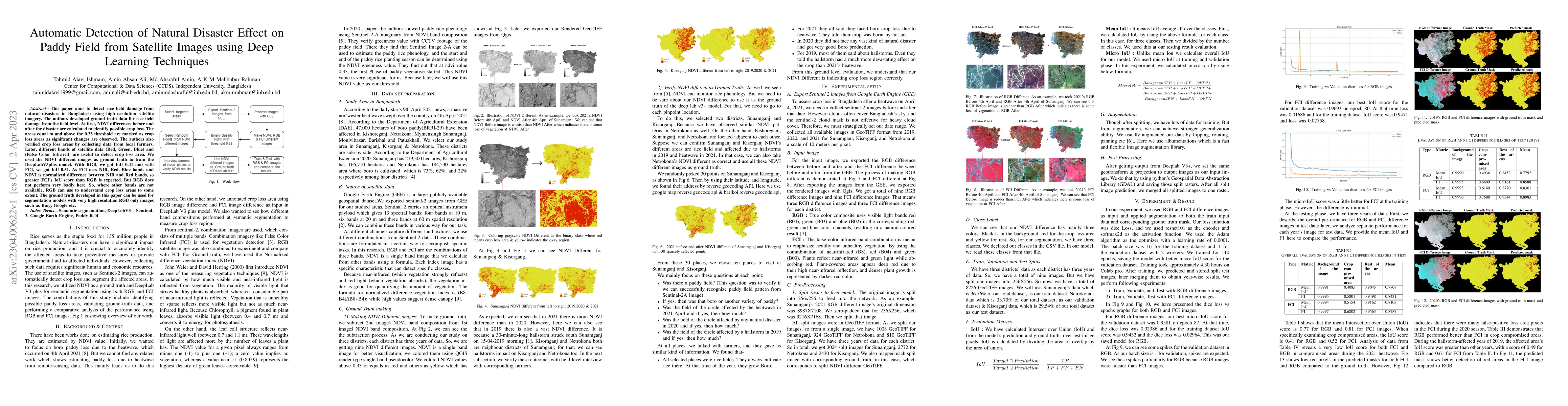
This paper aims to detect rice field damage from natural disasters in Bangladesh using high-resolution satellite imagery. The authors developed ground truth data for rice field damage from the field level. At first, NDVI differences before and after the disaster are calculated to identify possible crop loss. The areas equal to and above the 0.33 threshold are marked as crop loss areas as significant changes are observed. The authors also verified crop loss areas by collecting data from local farmers. Later, different bands of satellite data (Red, Green, Blue) and (False Color Infrared) are useful to detect crop loss area. We used the NDVI different images as ground truth to train the DeepLabV3plus model. With RGB, we got IoU 0.41 and with FCI, we got IoU 0.51. As FCI uses NIR, Red, Blue bands and NDVI is normalized difference between NIR and Red bands, so greater FCI's IoU score than RGB is expected. But RGB does not perform very badly here. So, where other bands are not available, RGB can use to understand crop loss areas to some extent. The ground truth developed in this paper can be used for segmentation models with very high resolution RGB only images such as Bing, Google etc.
AI Key Findings
Get AI-generated insights about this paper's methodology, results, significance, and more — seven facets brought into focus.
Impact
Paper Details
Authors
PDF Preview
Key Terms
Citation Network
Current paper (gray), citations (green), references (blue)
Display is limited for performance on very large graphs.
Discussion 0