Automatic Quantification of Settlement Damage using Deep Learning of Satellite Images
Publication
Metrics
AI Quick Summary
This paper presents a deep learning approach using satellite images to automatically quantify settlement damage from disasters. The method combines a ResNet for identifying destruction areas and a PSPNet for contextual quantification, followed by a multi-linear regression model to estimate overall damage, validated through the 2020 Beirut explosion.
Paper Preview
Abstract
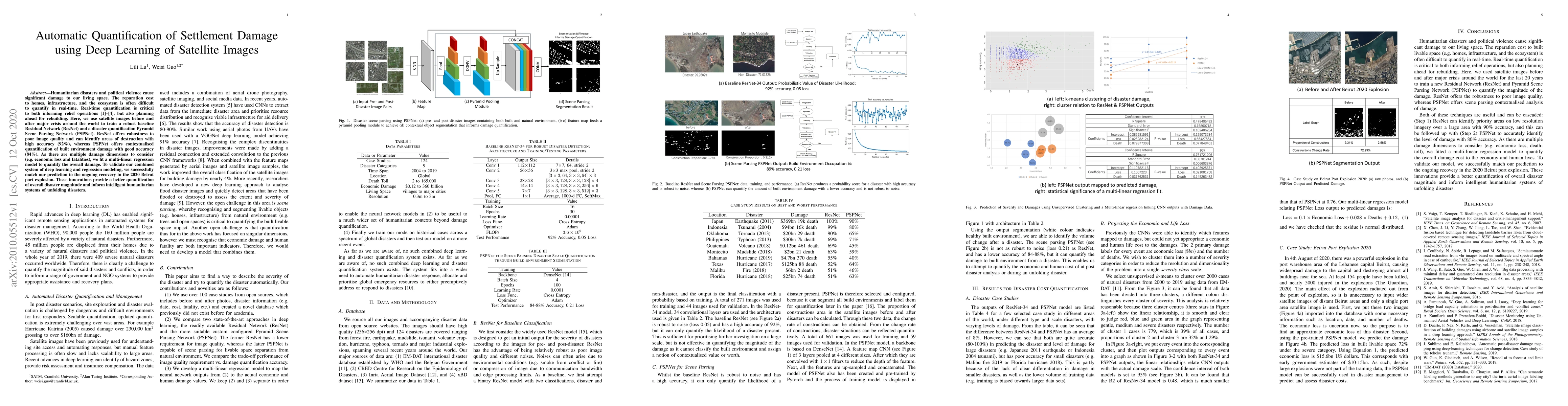
Humanitarian disasters and political violence cause significant damage to our living space. The reparation cost to homes, infrastructure, and the ecosystem is often difficult to quantify in real-time. Real-time quantification is critical to both informing relief operations, but also planning ahead for rebuilding. Here, we use satellite images before and after major crisis around the world to train a robust baseline Residual Network (ResNet) and a disaster quantification Pyramid Scene Parsing Network (PSPNet). ResNet offers robustness to poor image quality and can identify areas of destruction with high accuracy (92\%), whereas PSPNet offers contextualised quantification of built environment damage with good accuracy (84\%). As there are multiple damage dimensions to consider (e.g. economic loss and fatalities), we fit a multi-linear regression model to quantify the overall damage. To validate our combined system of deep learning and regression modeling, we successfully match our prediction to the ongoing recovery in the 2020 Beirut port explosion. These innovations provide a better quantification of overall disaster magnitude and inform intelligent humanitarian systems of unfolding disasters.
AI Key Findings
Get AI-generated insights about this paper's methodology, results, significance, and more — seven facets brought into focus.
Impact
Paper Details
Authors
PDF Preview
Key Terms
Citation Network
Current paper (gray), citations (green), references (blue)
Display is limited for performance on very large graphs.
Discussion 0