BD-SAT: High-resolution Land Use Land Cover Dataset & Benchmark Results for Developing Division: Dhaka, BD
Publication
Metrics
AI Quick Summary
BD-SAT presents a high-resolution land use land cover dataset for Dhaka, Bangladesh, with pixel-by-pixel annotations, enabling deep learning training for LULC analysis. Benchmark results show the dataset's efficacy in accurately classifying five major LULC classes.
Paper Preview
Abstract
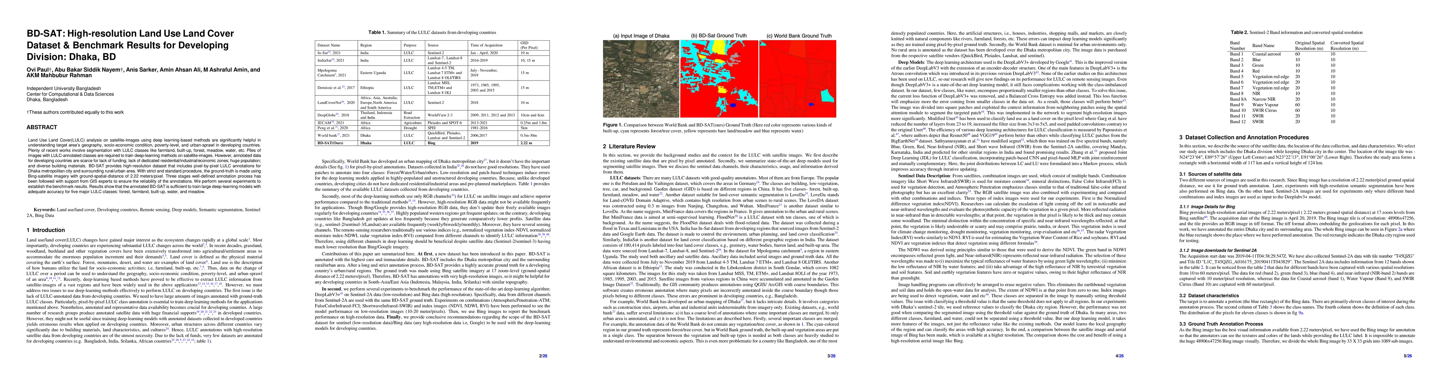
Land Use Land Cover (LULC) analysis on satellite images using deep learning-based methods is significantly helpful in understanding the geography, socio-economic conditions, poverty levels, and urban sprawl in developing countries. Recent works involve segmentation with LULC classes such as farmland, built-up areas, forests, meadows, water bodies, etc. Training deep learning methods on satellite images requires large sets of images annotated with LULC classes. However, annotated data for developing countries are scarce due to a lack of funding, absence of dedicated residential/industrial/economic zones, a large population, and diverse building materials. BD-SAT provides a high-resolution dataset that includes pixel-by-pixel LULC annotations for Dhaka metropolitan city and surrounding rural/urban areas. Using a strict and standardized procedure, the ground truth is created using Bing satellite imagery with a ground spatial distance of 2.22 meters per pixel. A three-stage, well-defined annotation process has been followed with support from GIS experts to ensure the reliability of the annotations. We performed several experiments to establish benchmark results. The results show that the annotated BD-SAT is sufficient to train large deep learning models with adequate accuracy for five major LULC classes: forest, farmland, built-up areas, water bodies, and meadows.
AI Key Findings
Get AI-generated insights about this paper's methodology, results, significance, and more — seven facets brought into focus.
Impact
Paper Details
Authors
PDF Preview
Key Terms
Citation Network
Current paper (gray), citations (green), references (blue)
Display is limited for performance on very large graphs.
Discussion 0