Beyond Residence: A Mobility-based Approach for Improved Evaluation of Human Exposure to Environmental Hazards
Publication
Metrics
AI Quick Summary
This study introduces a mobility-based index to evaluate human exposure to environmental hazards, moving beyond residential location to include daily activities and movements. It reveals that human mobility significantly extends hazard exposure, leading to latent exposure for populations outside high-hazard areas, and highlights the severe environmental injustices faced by poor and ethnic minority residents.
Paper Preview
Abstract
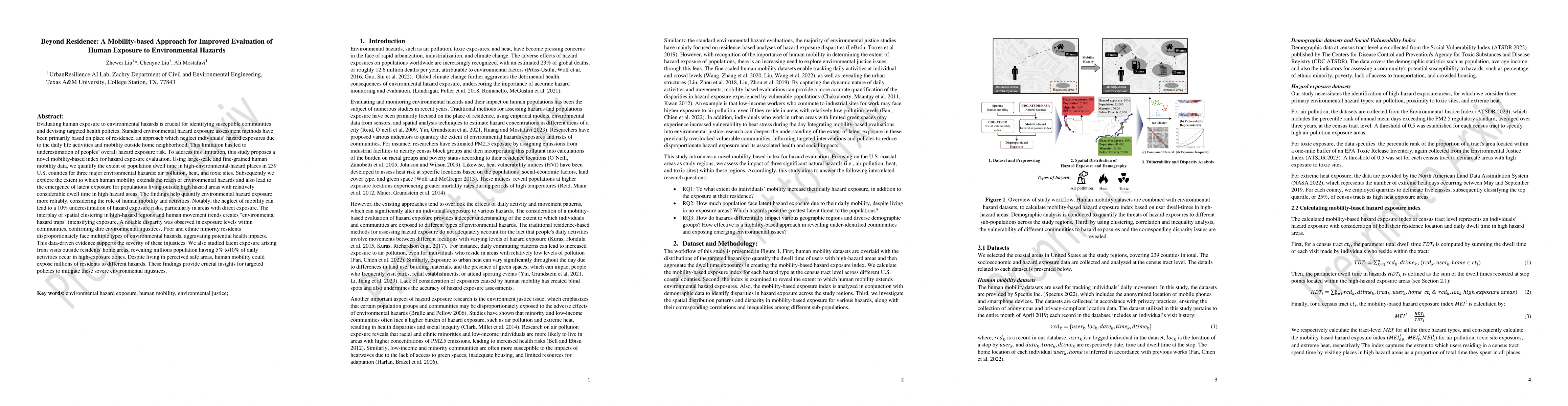
Evaluating human exposure to environmental hazards is crucial for identifying susceptible communities and devising targeted health policies. Standard environmental hazard exposure assessment methods have been primarily based on place of residence, an approach which neglect individuals hazard exposures due to the daily life activities and mobility outside home neighborhood. To address this limitation, this study proposes a novel mobility-based index for hazard exposure evaluation. Using large-scale and fine-grained human mobility data, we quantify the extent of population dwell time in high-environmental-hazard places in 239 U.S. counties for three major environmental hazards: air pollution, heat, and toxic sites. Subsequently we explore the extent to which human mobility extends the reach of environmental hazards and also lead to the emergence of latent exposure for populations living outside high hazard areas with relatively considerable dwell time in high hazard areas. The findings help quantify environmental hazard exposure more reliably, considering the role of human mobility and activities. The interplay of spatial clustering in high-hazard regions and human movement trends creates environmental hazard traps intensifying exposure. Poor and ethnic minority residents disproportionately face multiple types of environmental hazards, aggravating potential health impacts. This data-driven evidence supports the severity of these injustices. We also studied latent exposure arising from visits outside residents' home areas, revealing millions population having 5% to10% of daily activities occur in high-exposure zones. Despite living in perceived safe areas, human mobility could expose millions of residents to different hazards. These findings provide crucial insights for targeted policies to mitigate these severe environmental injustices
AI Key Findings
Get AI-generated insights about this paper's methodology, results, significance, and more — seven facets brought into focus.
Impact
Paper Details
Authors
PDF Preview
Key Terms
Citation Network
Current paper (gray), citations (green), references (blue)
Display is limited for performance on very large graphs.
Discussion 0