Academic Profile
Statistics
Similar Authors
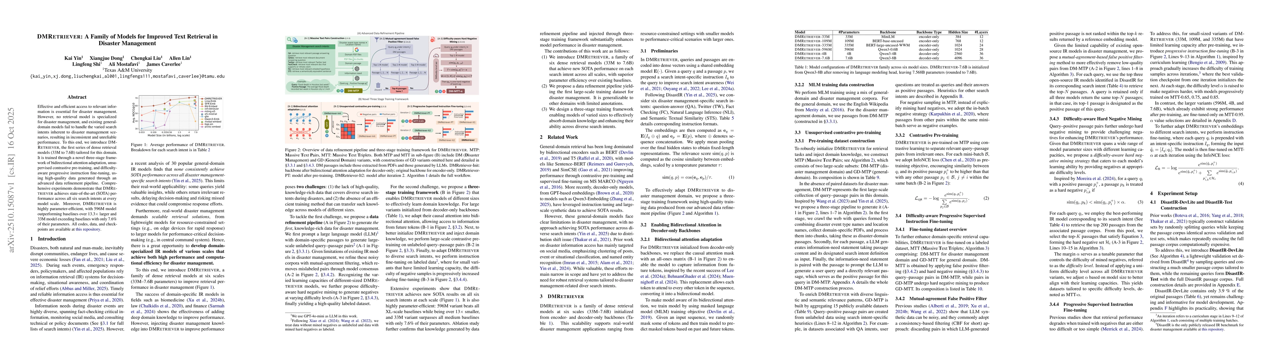
Papers on arXiv
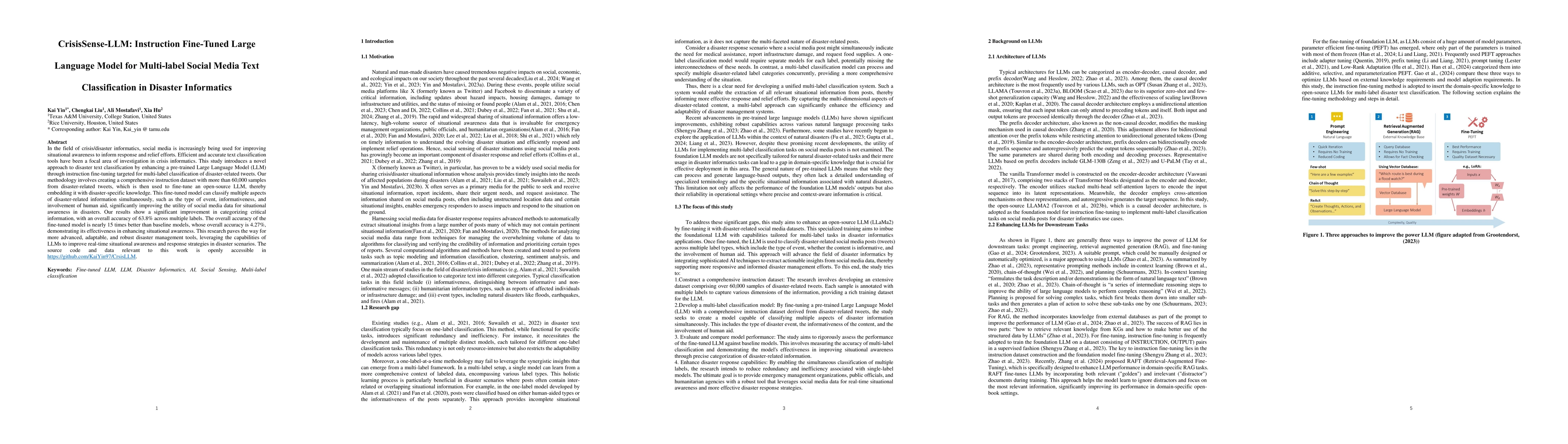
In the field of crisis/disaster informatics, social media is increasingly being used for improving situational awareness to inform response and relief efforts. Efficient and accurate text classificati...
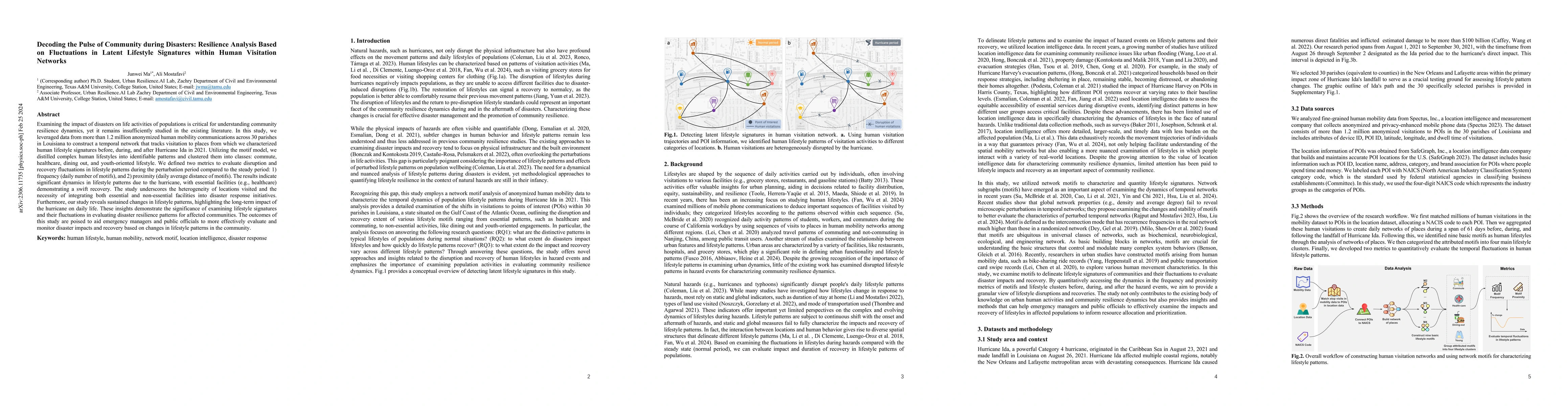
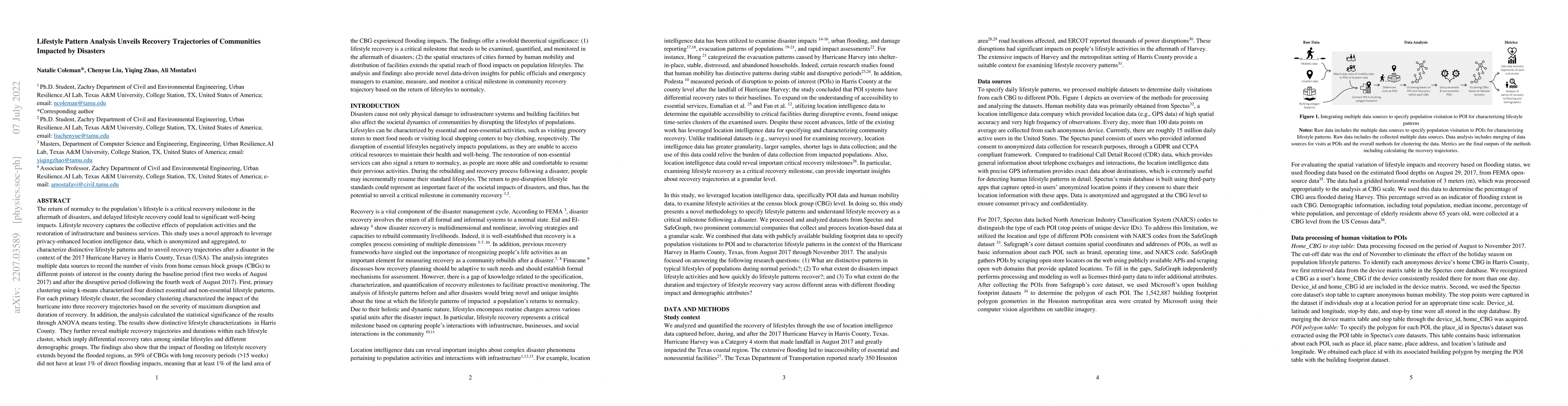
Understanding sequential community recovery milestones is crucial for proactive recovery planning and monitoring. This study investigates these milestones related to population activities to examine t...
This study presents a granular analysis of societal recovery from disasters at the individual level, focusing on the aftermath of Hurricane Harvey and Hurricane Ida. Societal recovery is defined as ...
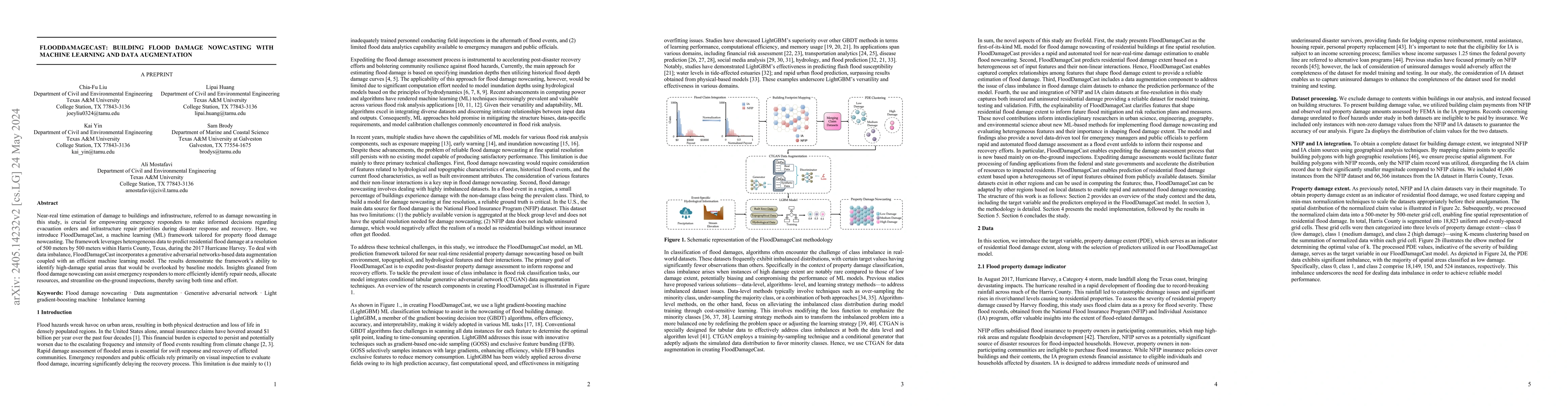
Near-real time estimation of damage to buildings and infrastructure, referred to as damage nowcasting in this study, is crucial for empowering emergency responders to make informed decisions regardi...
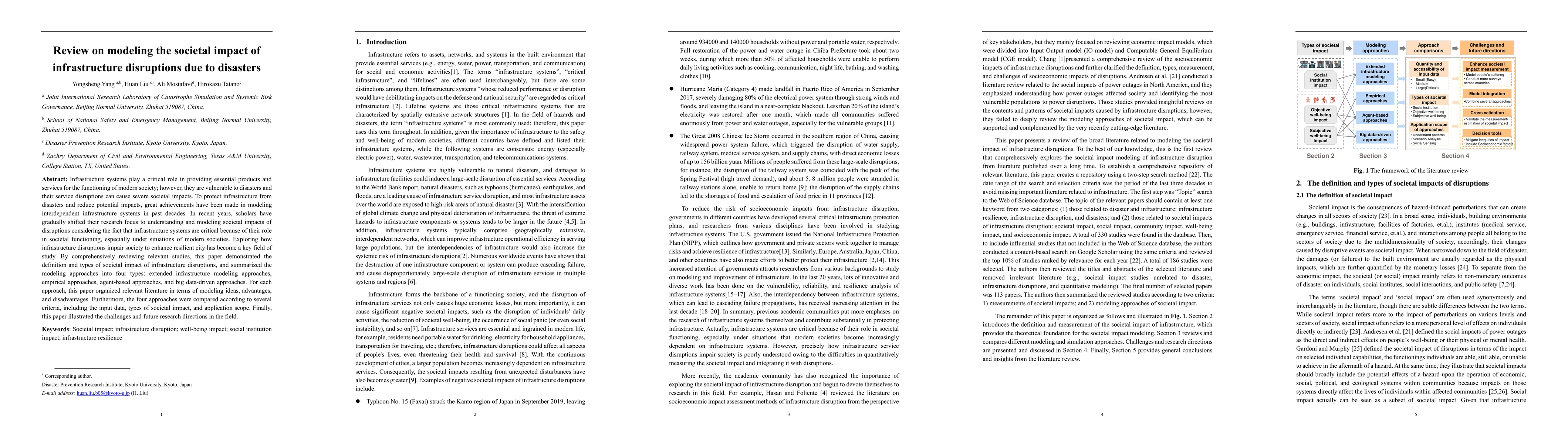
Infrastructure systems play a critical role in providing essential products and services for the functioning of modern society; however, they are vulnerable to disasters and their service disruption...
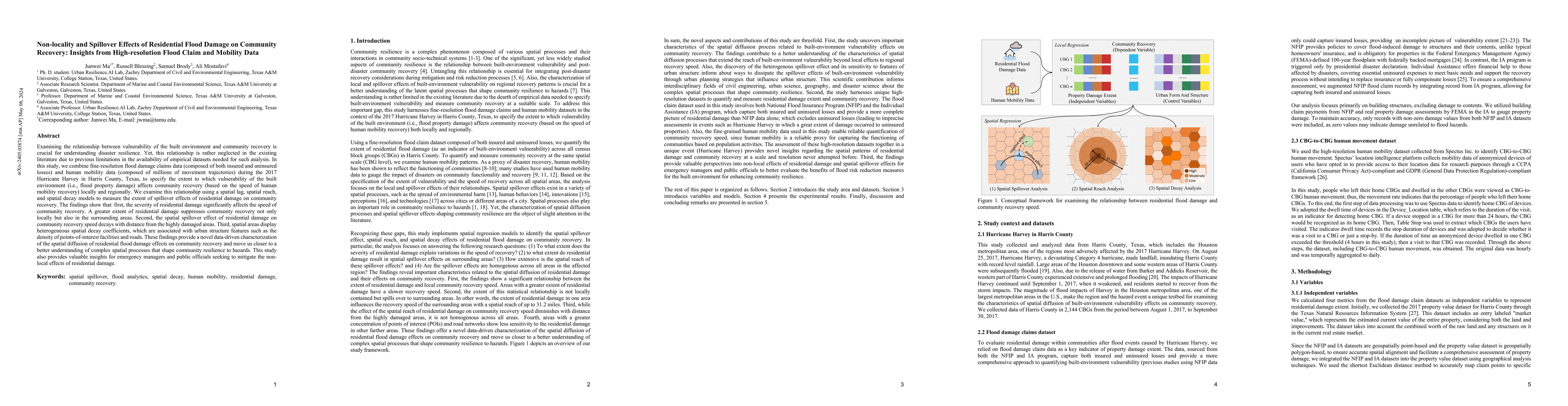
Examining the relationship between vulnerability of the built environment and community recovery is crucial for understanding disaster resilience. Yet, this relationship is rather neglected in the e...
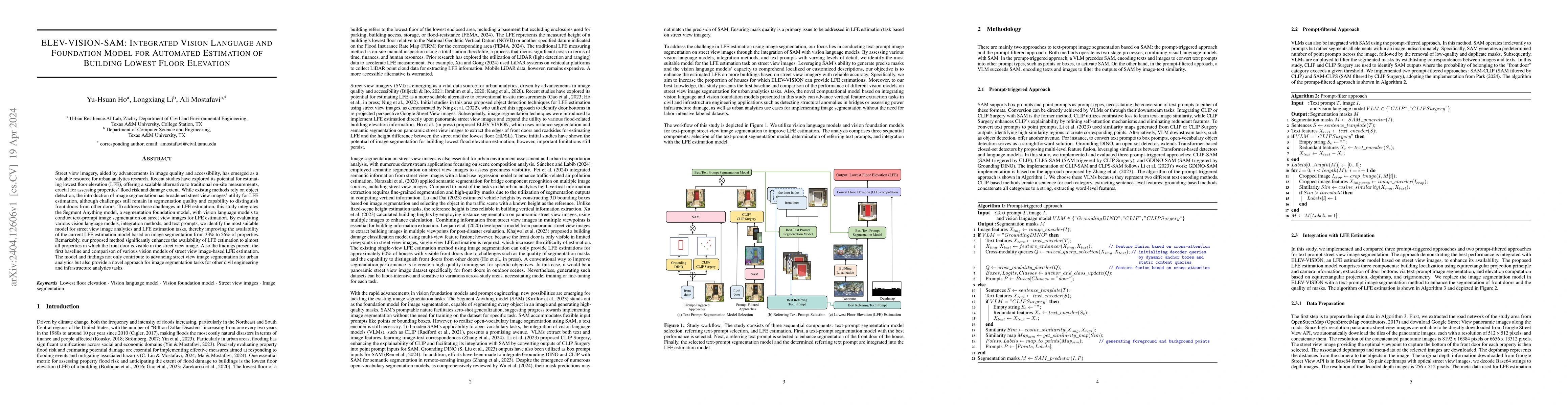
Street view imagery, aided by advancements in image quality and accessibility, has emerged as a valuable resource for urban analytics research. Recent studies have explored its potential for estimat...
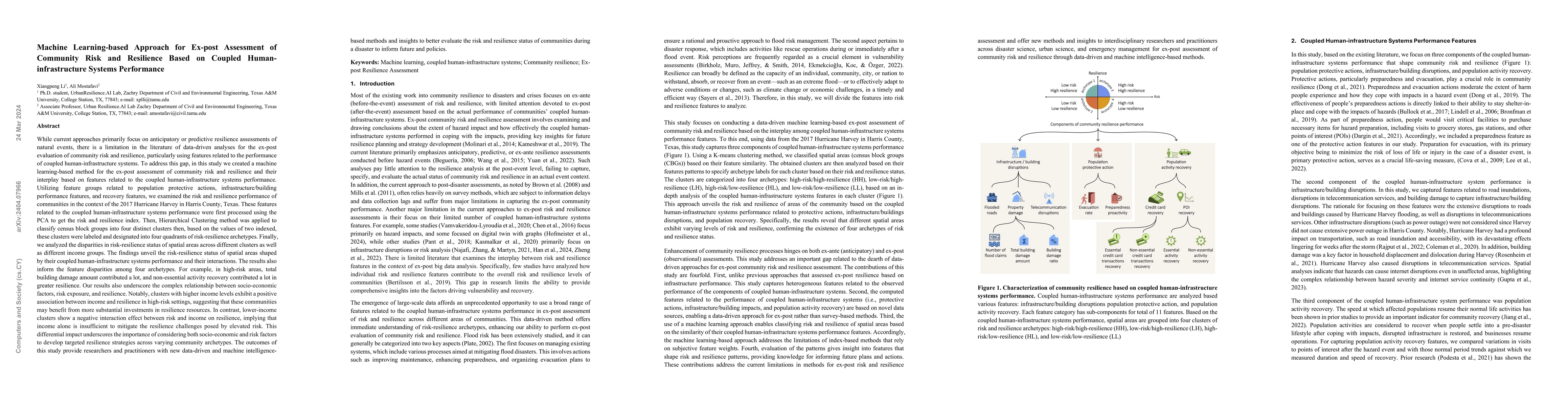
There is a limitation in the literature of data-driven analyses for the ex-post evaluation of community risk and resilience, particularly using features related to the performance of coupled human-i...
The objective of this study is to characterize inequality in infrastructure quality across urban areas. While a growing of body of literature has recognized the importance of characterizing infrastr...
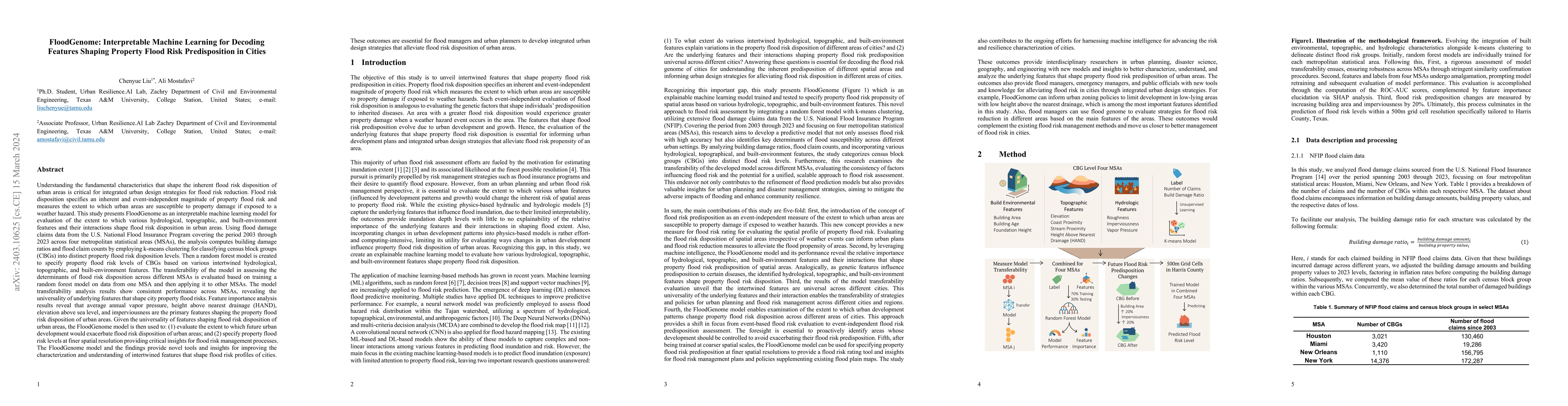
Understanding the fundamental characteristics that shape the inherent flood risk disposition of urban areas is critical for integrated urban design strategies for flood risk reduction. Flood risk di...
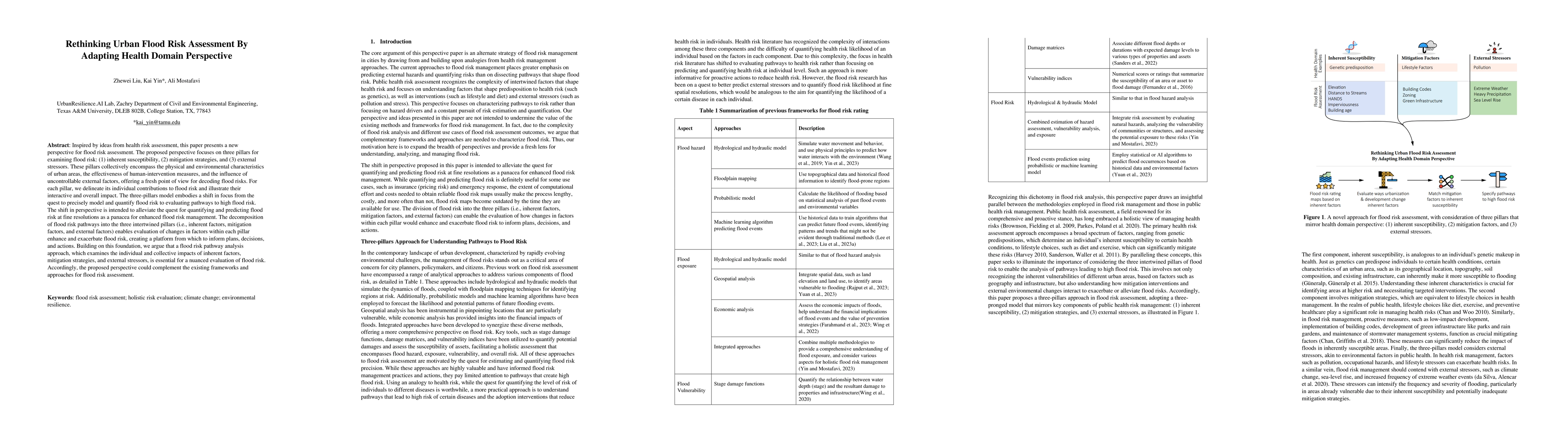
Inspired by ideas from health risk assessment, this paper presents a new perspective for flood risk assessment. The proposed perspective focuses on three pillars for examining flood risk: (1) inhere...
Examining the impact of disasters on life activities of populations is critical for understanding community resilience dynamics, yet it remains insufficiently studied in the existing literature. In ...
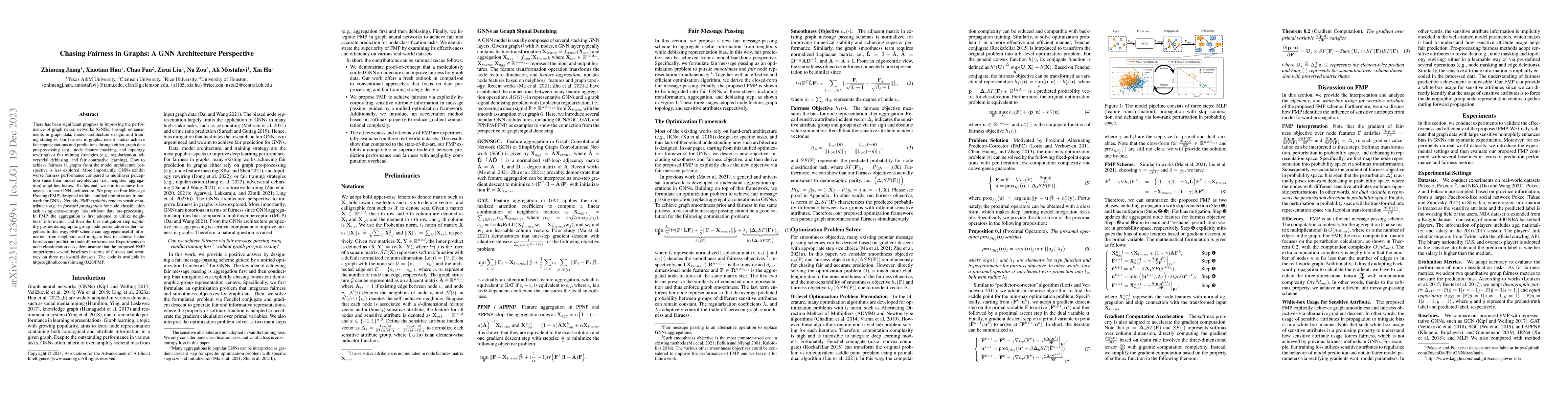
There has been significant progress in improving the performance of graph neural networks (GNNs) through enhancements in graph data, model architecture design, and training strategies. For fairness ...
The resilience of internet service is crucial for ensuring consistent communication, facilitating emergency response in digitally-dependent society. Due to empirical data constraints, there has been...
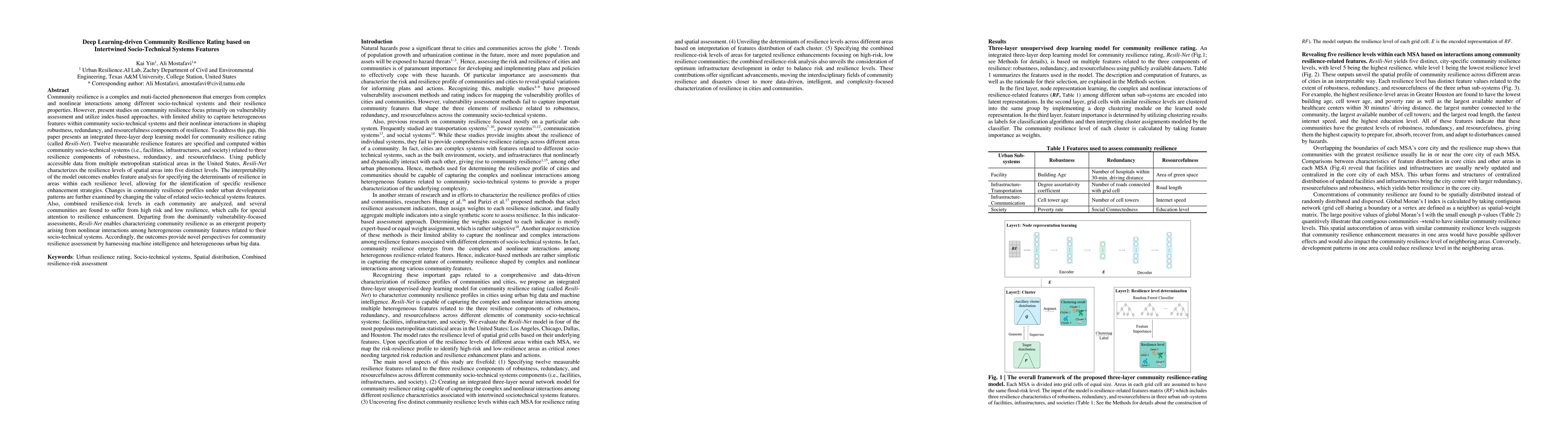
Community resilience is a complex and muti-faceted phenomenon that emerges from complex and nonlinear interactions among different socio-technical systems and their resilience properties. However, p...
After about a decade of research in this domain, what is missing is a systematic overview of the research agenda across different infrastructures and hazards. It is now imperative to evaluate the cu...
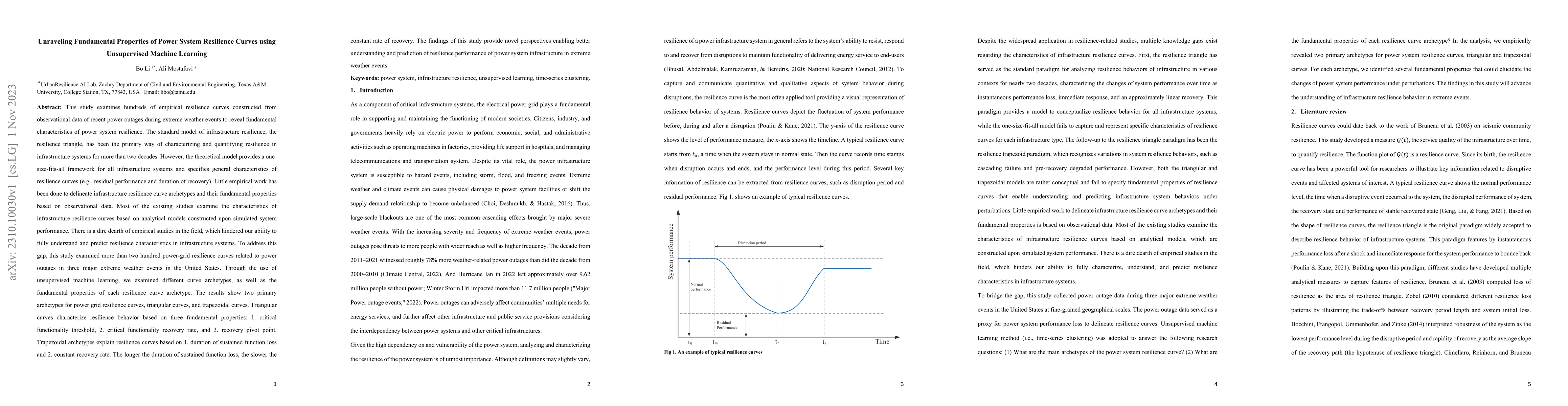
The standard model of infrastructure resilience, the resilience triangle, has been the primary way of characterizing and quantifying infrastructure resilience. However, the theoretical model merely ...

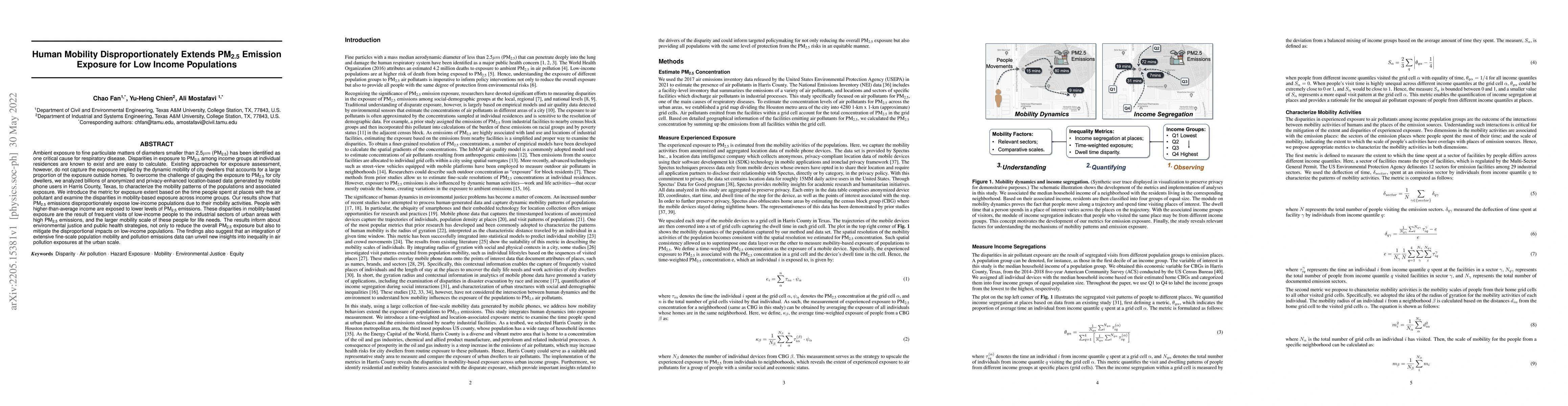
Understanding the key factors shaping environmental hazard exposures and their associated environmental injustice issues is vital for formulating equitable policy measures. Traditional perspectives ...
Resilience curves have been the primary approach for conceptualizing and representing the resilience behavior of communities during hazard events; however, the use of resilience curves has remained ...
Urban flood risk emerges from complex and nonlinear interactions among multiple features related to flood hazard, flood exposure, and social and physical vulnerabilities, along with the complex spat...
Despite recognition of the relationship between infrastructure resilience and community recovery, very limited empirical evidence exists regarding the extent to which the disruptions in and restorat...
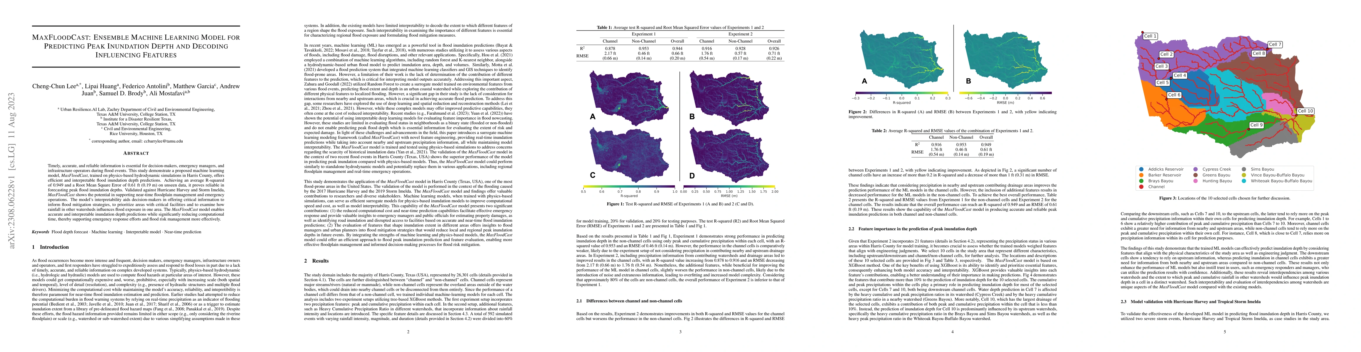
Timely, accurate, and reliable information is essential for decision-makers, emergency managers, and infrastructure operators during flood events. This study demonstrates a proposed machine learning...
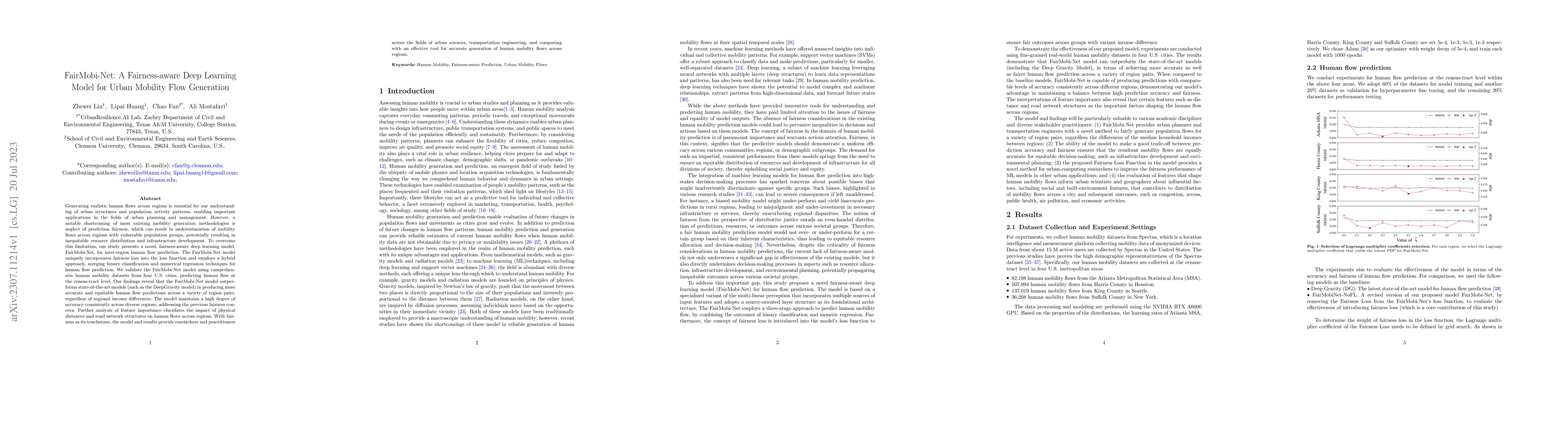
Generating realistic human flows across regions is essential for our understanding of urban structures and population activity patterns, enabling important applications in the fields of urban planni...
Current characterization of flood exposure is largely based on residential location of populations; however, location of residence only partially captures the extent to which populations are exposed...
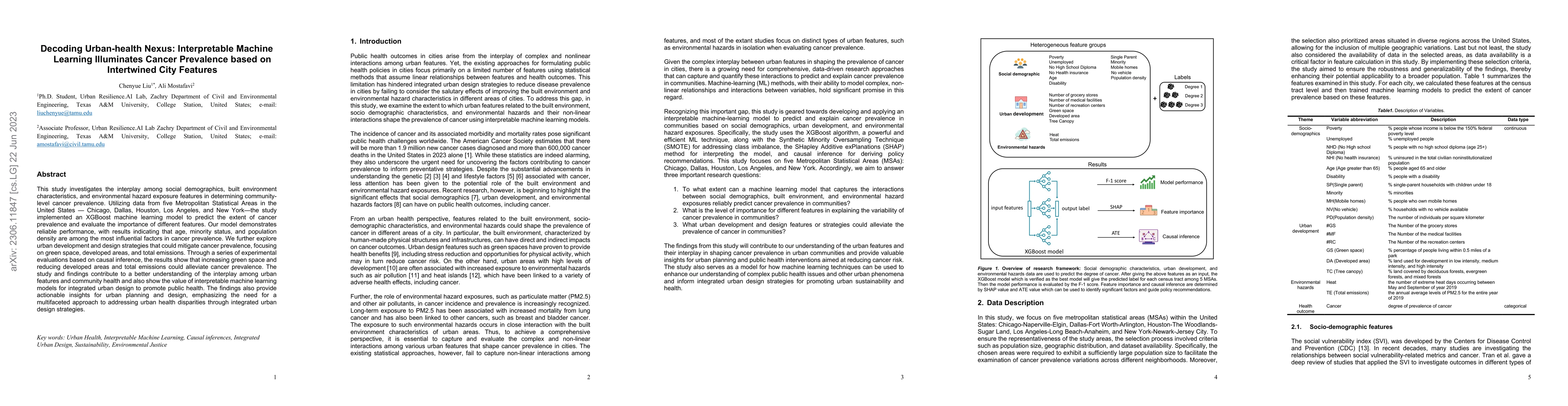
This study investigates the interplay among social demographics, built environment characteristics, and environmental hazard exposure features in determining community level cancer prevalence. Utili...
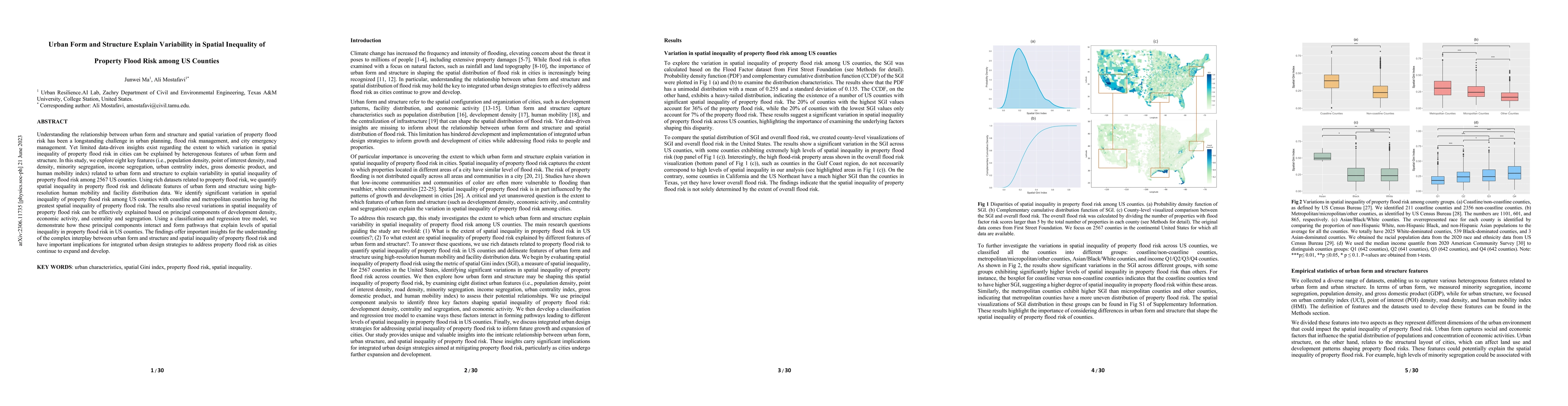
Understanding the relationship between urban form and structure and spatial variation of property flood risk has been a longstanding challenge in urban planning and city flood risk management. Yet l...
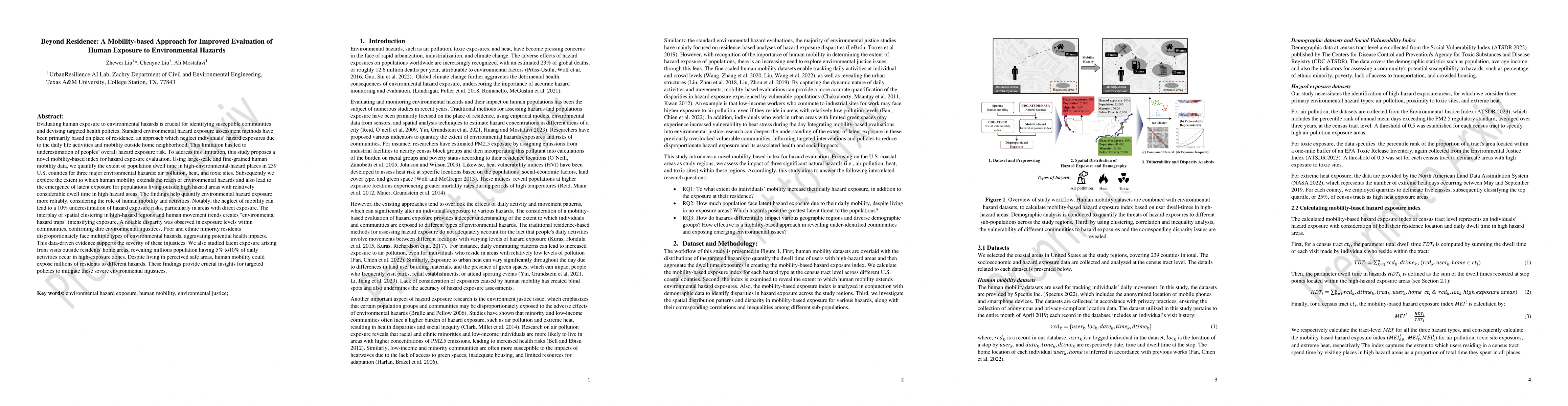
Evaluating human exposure to environmental hazards is crucial for identifying susceptible communities and devising targeted health policies. Standard environmental hazard exposure assessment methods...
End-stage renal disease patients face a complicated sociomedical situation and rely on various forms of infrastructure for life-sustaining treatment. Disruption of these infrastructures during disas...
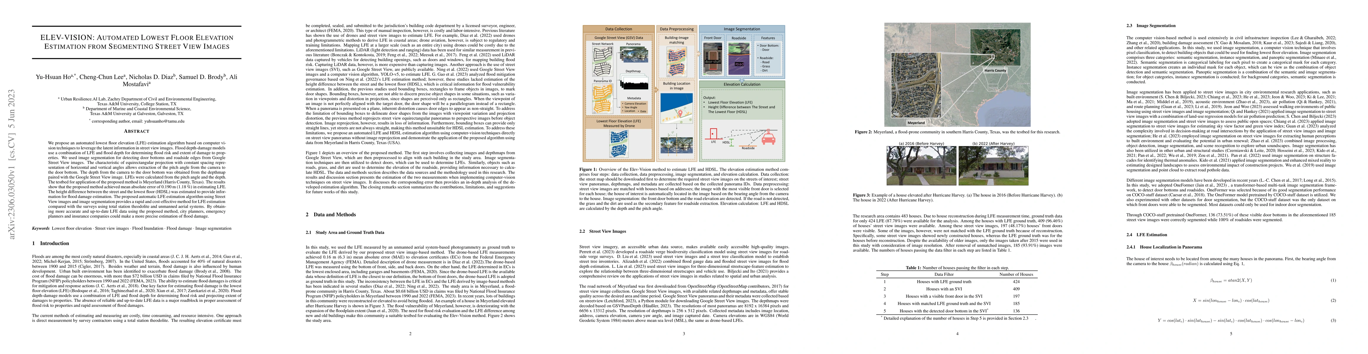
We propose an automated lowest floor elevation (LFE) estimation algorithm based on computer vision techniques to leverage the latent information in street view images. Flood depth-damage models use ...
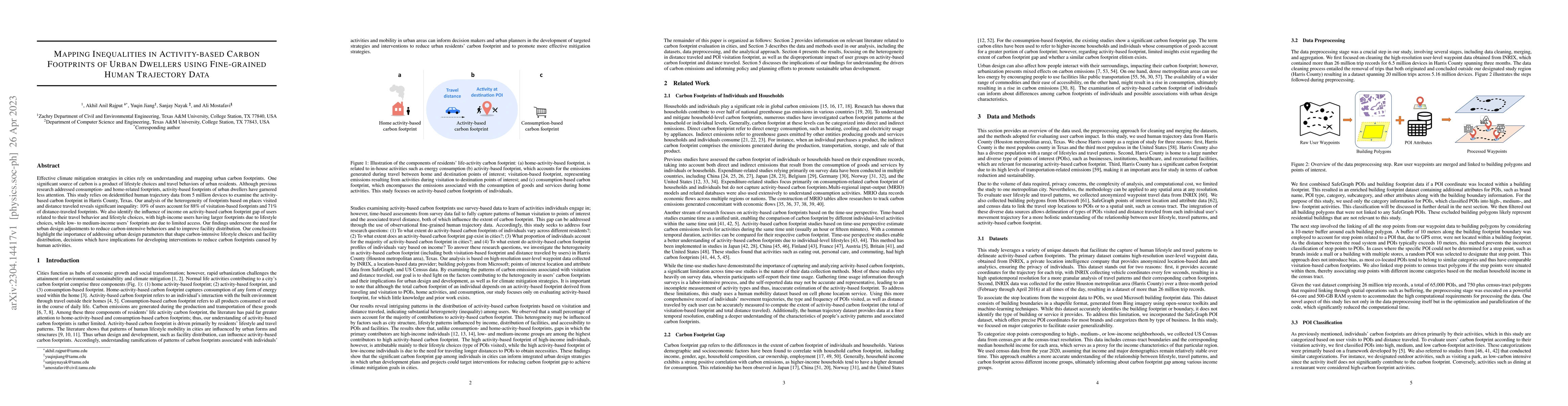
Effective climate mitigation strategies in cities rely on understanding and mapping urban carbon footprints. One significant source of carbon is a product of lifestyle choices and travel behaviors o...
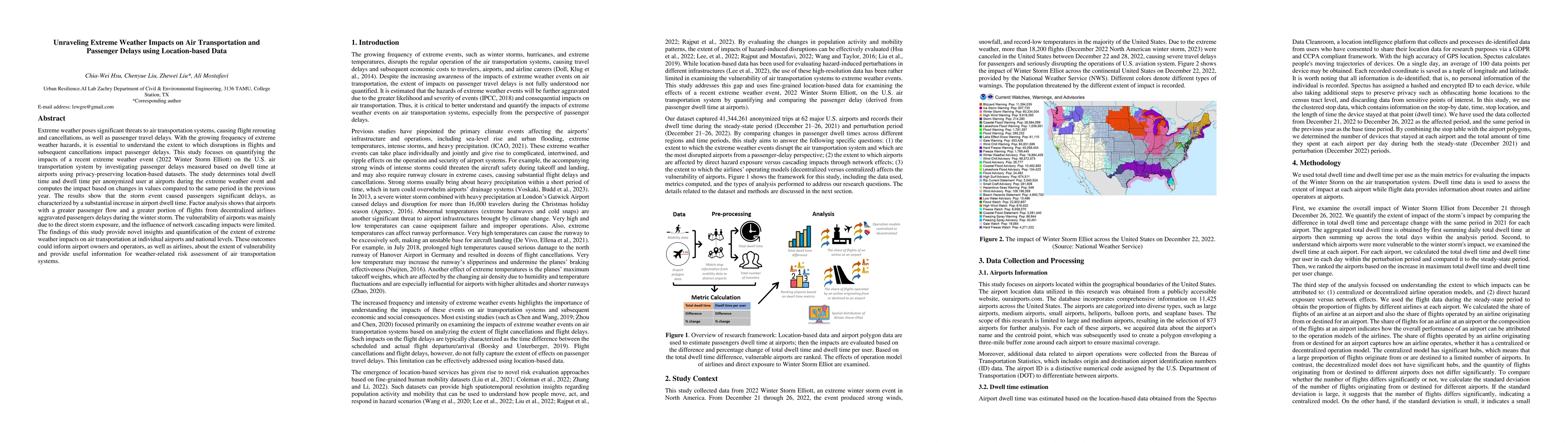
Extreme weather poses significant threats to air transportation systems, causing flight rerouting and cancellations, as well as passenger travel delays. With the growing frequency of extreme weather...
ChatGPT has been emerging as a novel information source, and it is likely that the public might seek information from ChatGPT while taking protective actions when facing climate hazards such as floo...
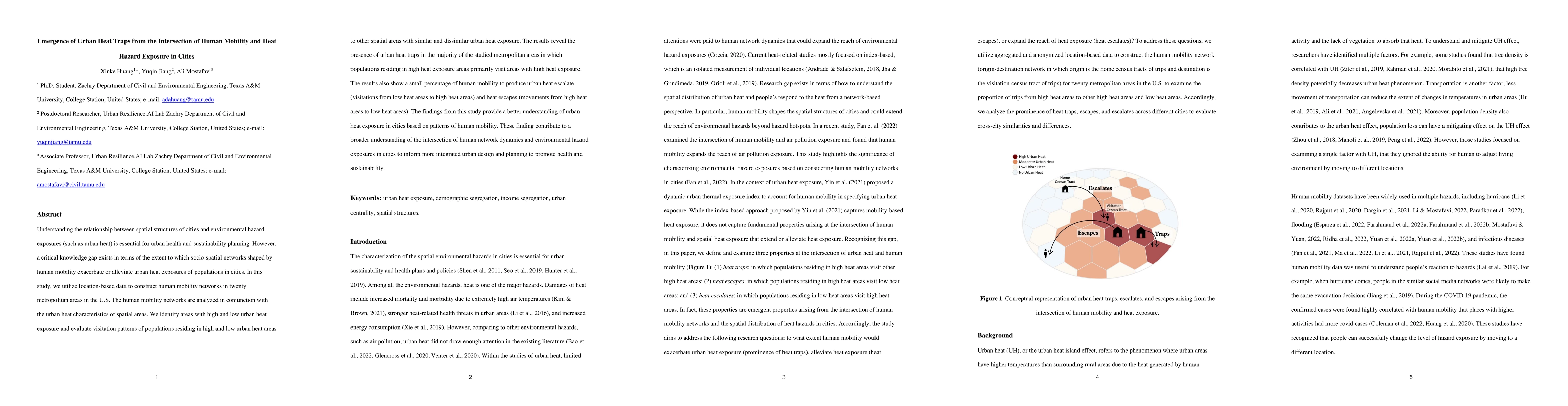
Understanding the relationship between spatial structures of cities and environmental hazard exposures (such as urban heat) is essential for urban health and sustainability planning. However, a crit...
Global sea-level rise causes increasing threats of coastal flood and subsequent pollutant dispersion. However, there are still few studies on the disparity arising from such threats and the extent t...
The ability to measure and track the speed and trajectory of a community's post-disaster recovery is essential to inform resource allocation and prioritization. The current survey-based approaches t...
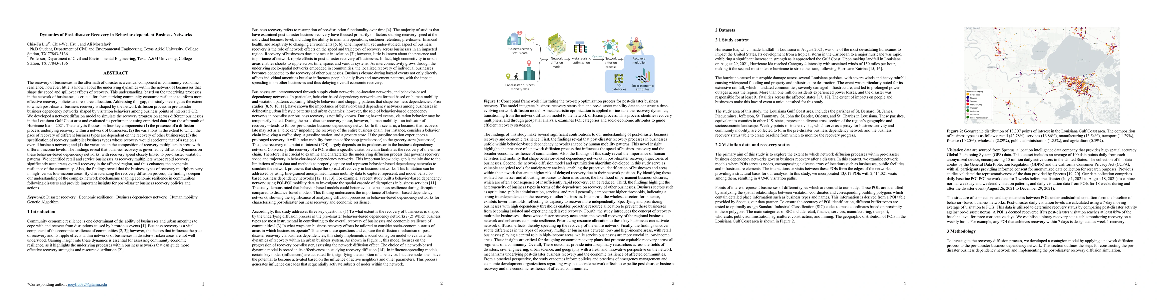
Community recovery from hazards and crises occurs through various diffusion processes within social and spatial networks of communities. Existing knowledge regarding the diffusion of recovery in com...
The energy sector in the United States is ever more vulnerable to extreme climatic hazards, leading to multiple hazard-induced and managed power outages. Utility companies reportedly prioritize the ...
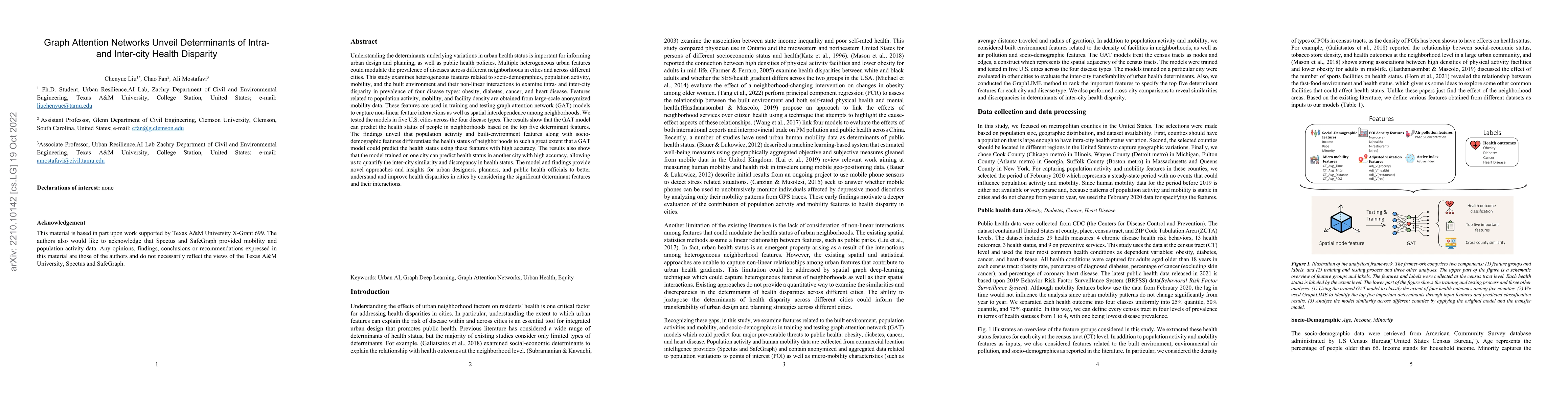
Understanding the determinants underlying variations in urban health status is important for informing urban design and planning, as well as public health policies. Multiple heterogeneous urban feat...
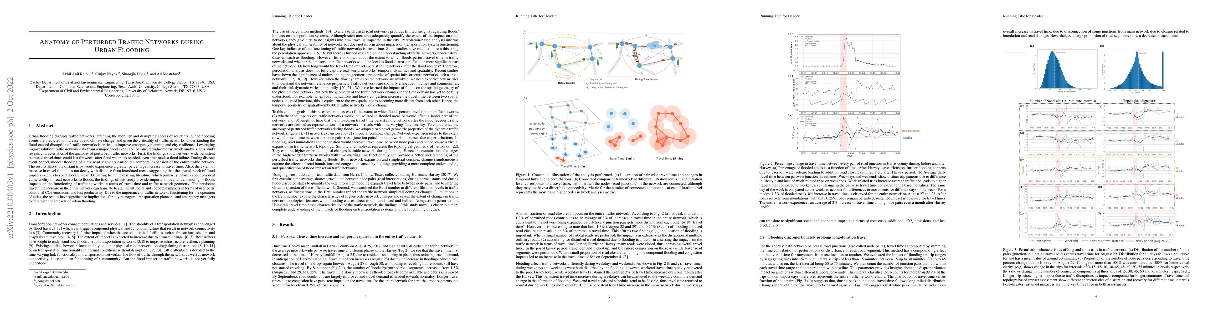
Urban flooding disrupts traffic networks, affecting the mobility and disrupting access of residents. Since flooding events are predicted to increase due to climate change, and given the criticality ...
The spread of COVID-19 revealed that transmission risk patterns are not homogenous across different cities and communities, and various heterogeneous features can influence the spread trajectories. ...
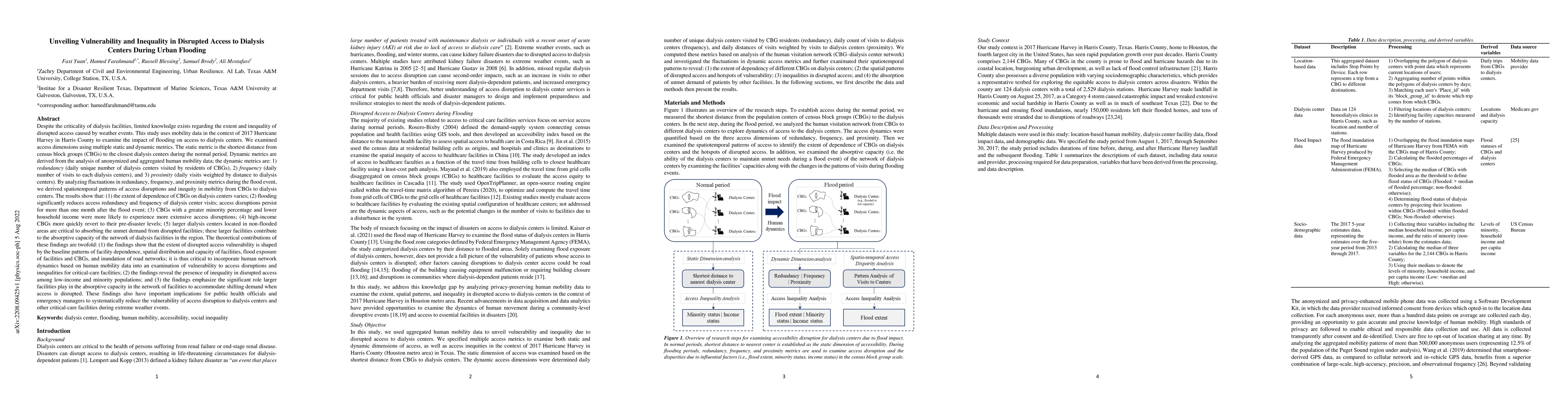
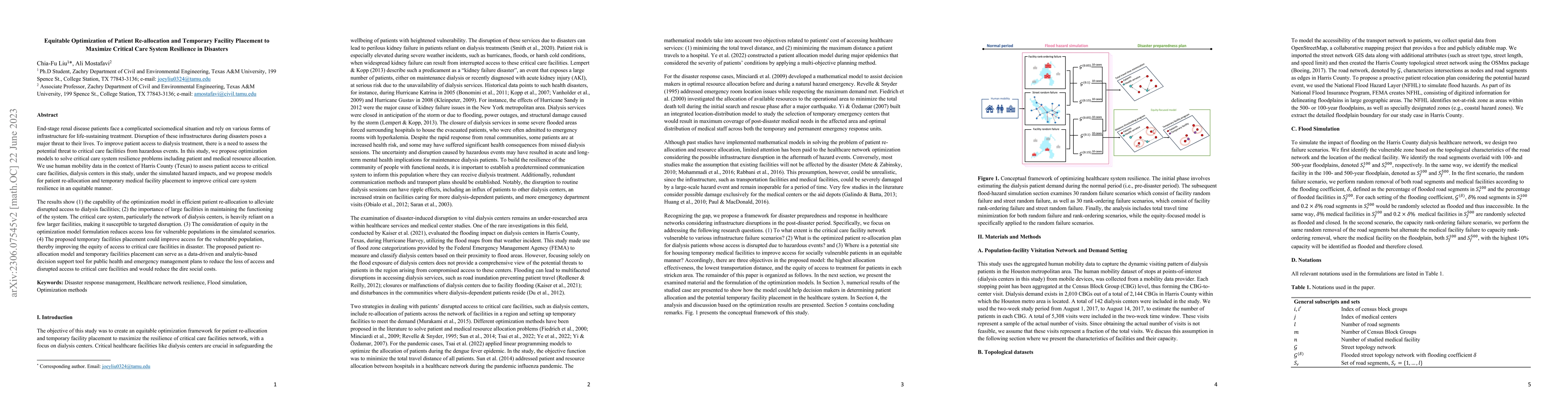
Despite the criticality of dialysis facilities, limited knowledge exists regarding the extent and inequality of disrupted access caused by weather events. This study uses mobility data in the contex...
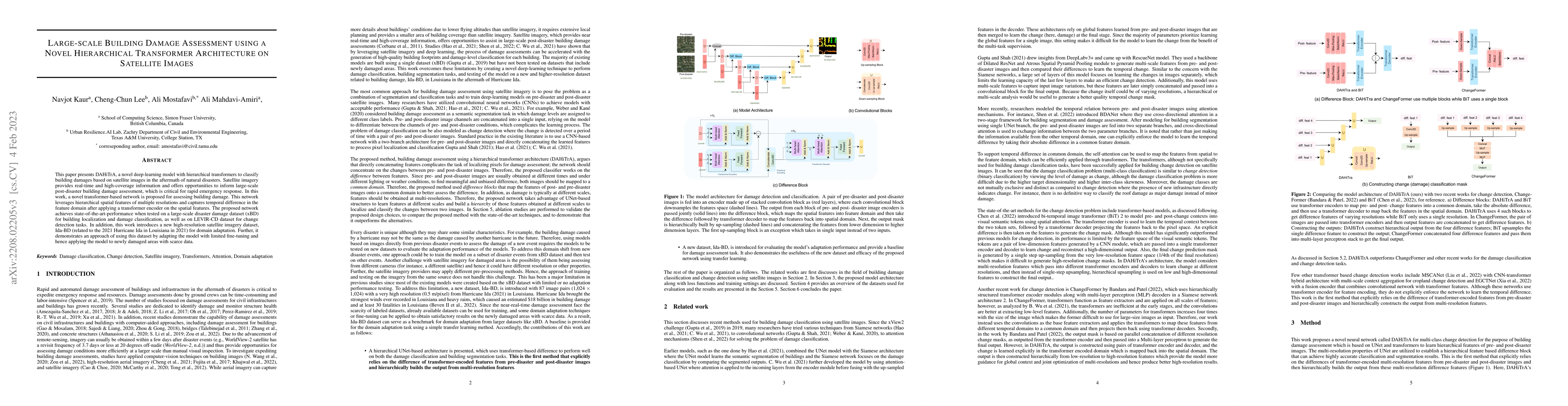
This paper presents \dahitra, a novel deep-learning model with hierarchical transformers to classify building damages based on satellite images in the aftermath of natural disasters. Satellite image...
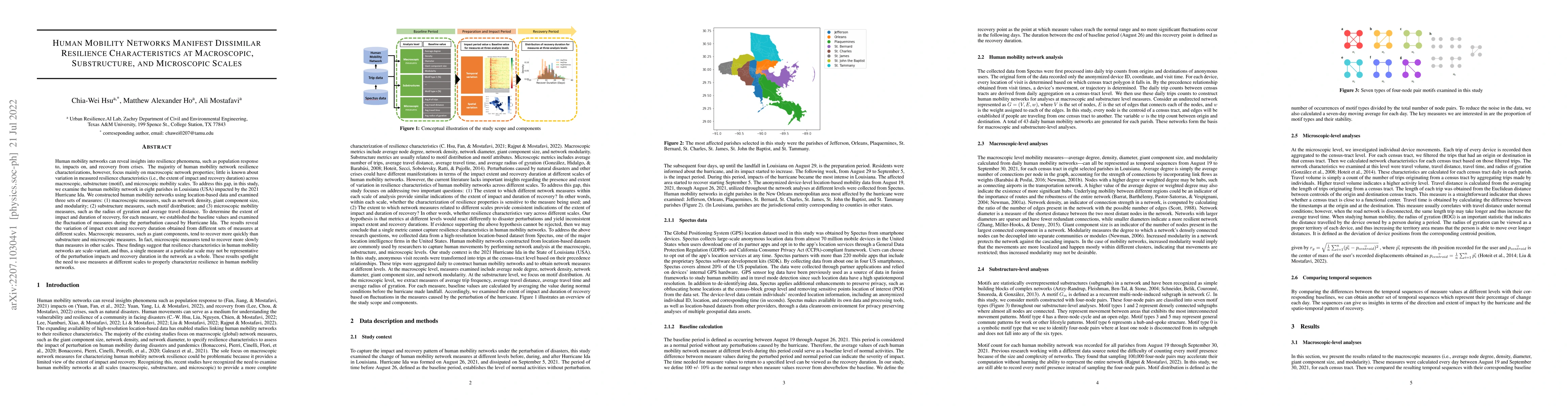
Human mobility networks can reveal insights into resilience phenomena, such as population response to, impacts on, and recovery from crises. The majority of human mobility network resilience charact...
Novel data sensing and AI technologies are finding practical use in the analysis of crisis resilience, revealing the need to consider how responsible artificial intelligence (AI) practices can mitig...
The use of crowdsourced data has been finding practical use for enhancing situational awareness during disasters. While recent studies have shown promising results regarding the potential of crowdso...
The return of normalcy to the population's lifestyle is a critical recovery milestone in the aftermath of disasters, and delayed lifestyle recovery could lead to significant well-being impacts. Life...
Ambient exposure to fine particulate matters of diameters smaller than 2.5{\mu}m (PM2.5) has been identified as one critical cause for respiratory disease. Disparities in exposure to PM2.5 among inc...
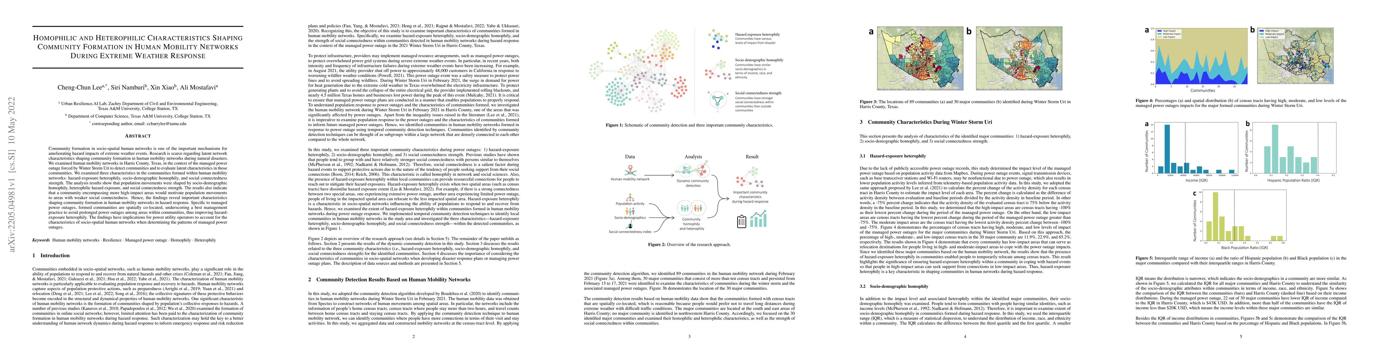
Community formation in socio-spatial human networks is one of the important mechanisms for ameliorating hazard impacts of extreme weather events. Research is scarce regarding latent network characte...
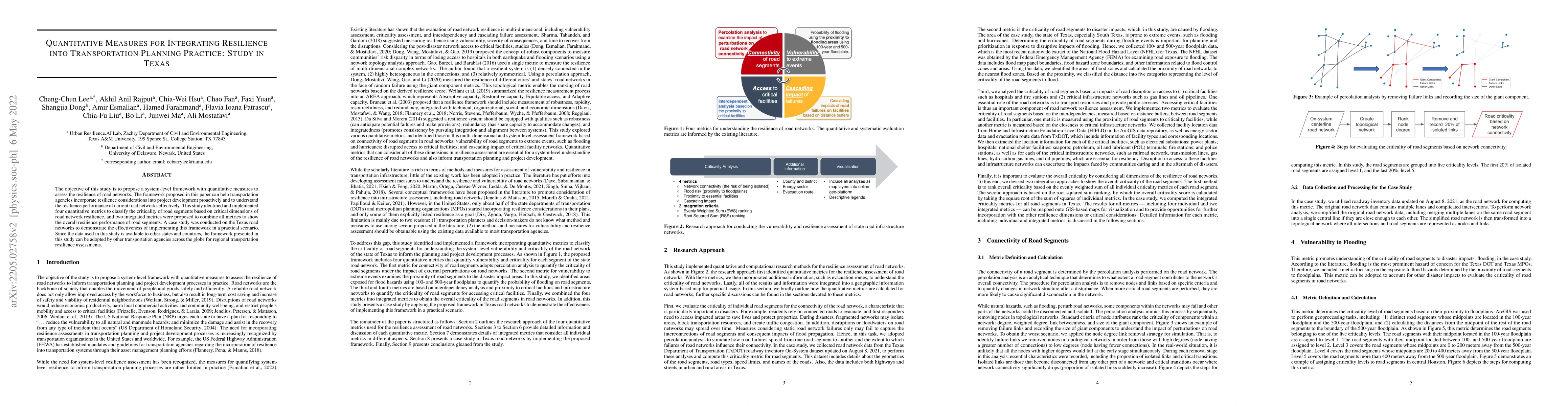
The objective of this study is to propose a system-level framework with quantitative measures to assess the resilience of road networks. The framework proposed in this paper can help transportation ...
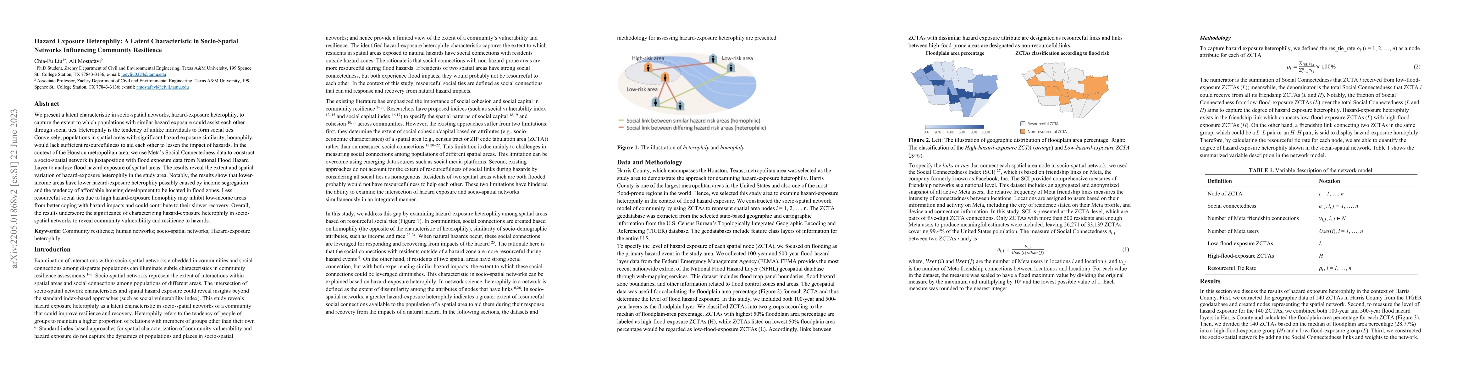
We present a latent characteristic in socio-spatial networks, hazard-exposure heterophily, to capture the extent to which populations with similar hazard exposure could assist each other through soc...
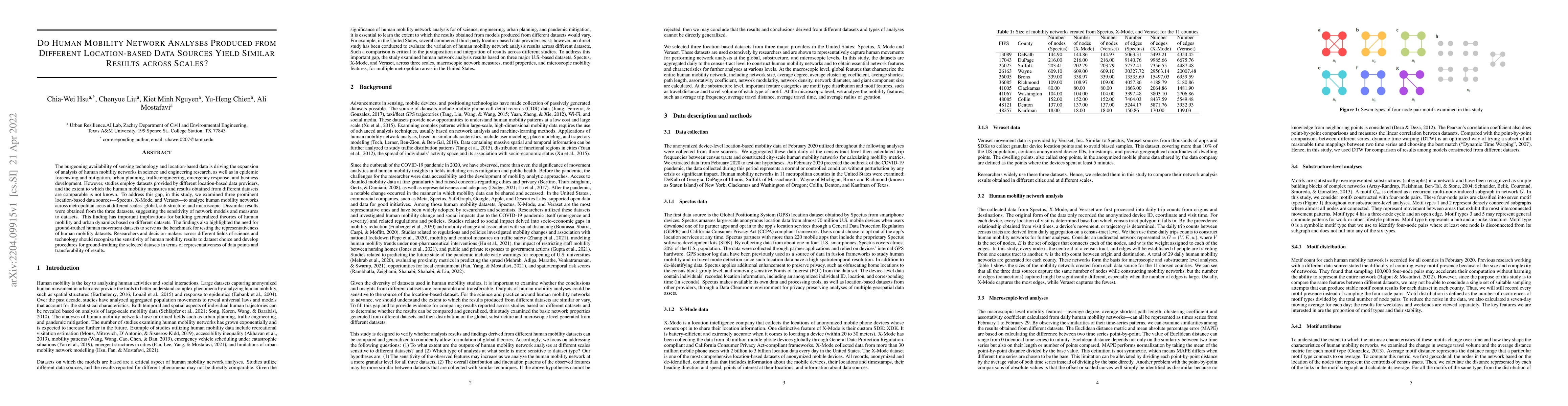
The burgeoning availability of sensing technology and location-based data is driving the expansion of analysis of human mobility networks in science and engineering research, as well as in epidemic ...
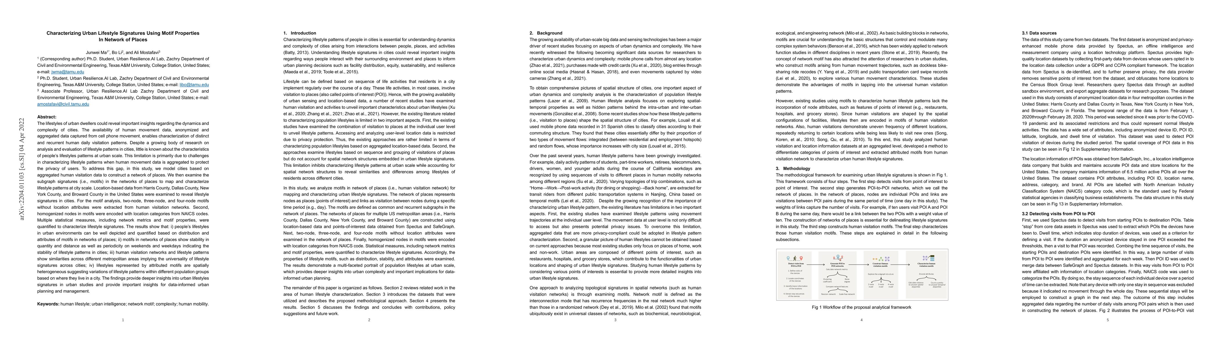
The lifestyles of urban dwellers could reveal important insights regarding the dynamics and complexity of cities. Despite growing research on analysis of lifestyle patterns in cities, little is know...
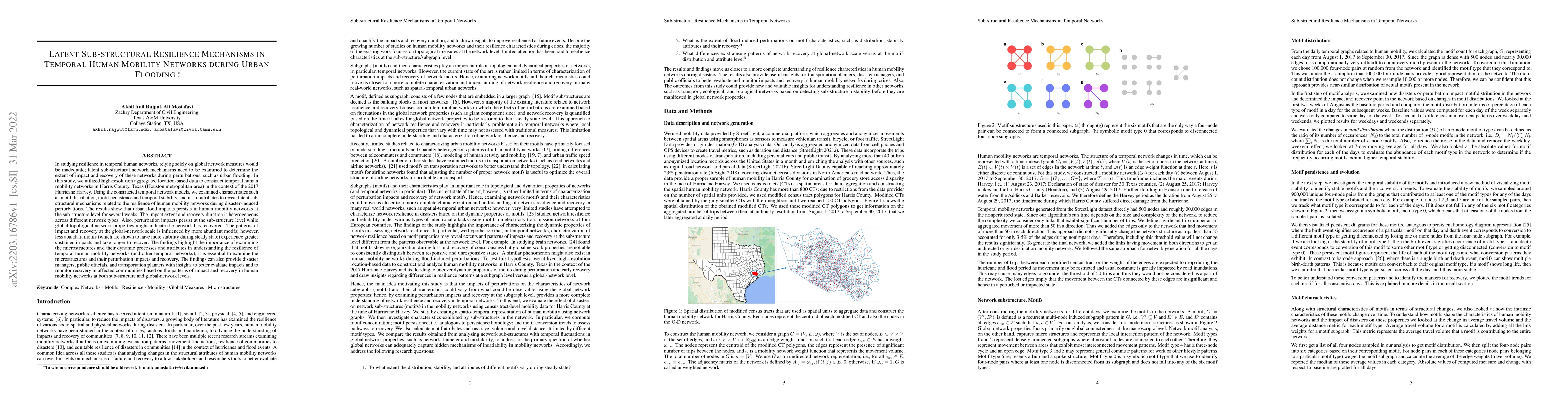
In studying resilience in temporal human networks, relying solely on global network measures would be inadequate; latent sub-structural network mechanisms need to be examined to determine the extent...
Improving hurricane preparedness is essential to reduce hurricane impacts. Inherent in traditional methods for quantifying and monitoring hurricane preparedness are significant lags. This study esta...
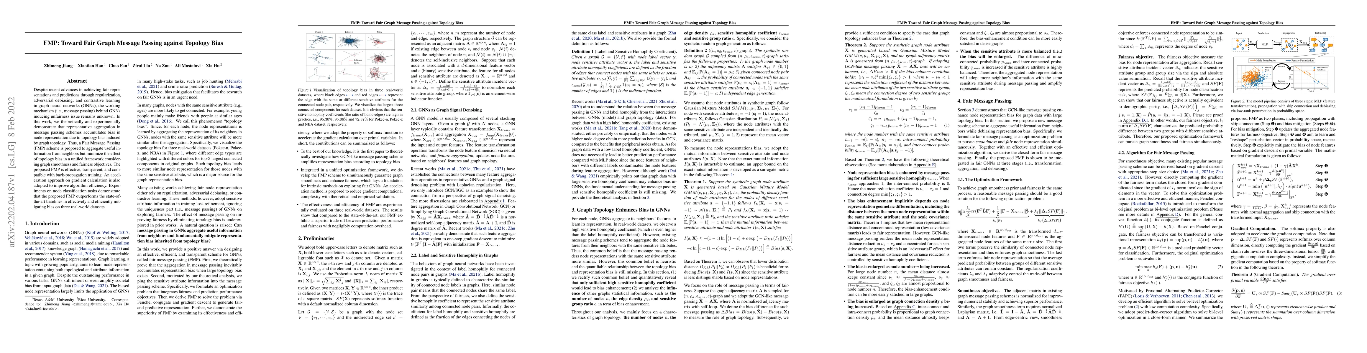
Despite recent advances in achieving fair representations and predictions through regularization, adversarial debiasing, and contrastive learning in graph neural networks (GNNs), the working mechani...
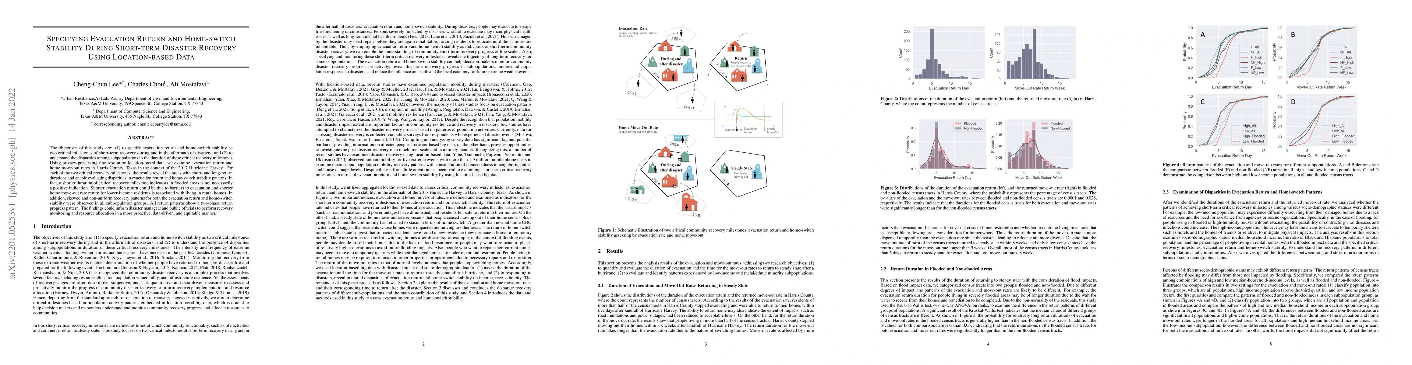
The objectives of this study are: (1) to specify evacuation return and home-switch stability as two critical milestones of short-term recovery during and in the aftermath of disasters; and (2) to un...
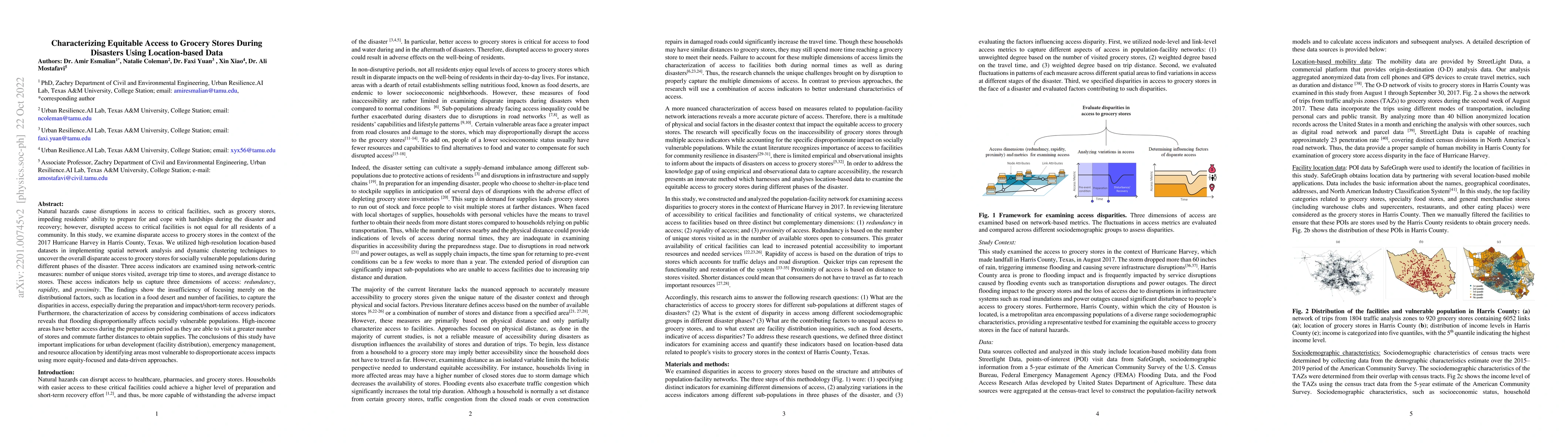
Natural hazards cause disruptions in access to critical facilities, such as grocery stores, impeding residents ability to prepare for and cope with hardships during the disaster and recovery; howeve...
The objective of this study is to develop and test a novel structured deep-learning modeling framework for urban flood nowcasting by integrating physics-based and human-sensed features. We present a...
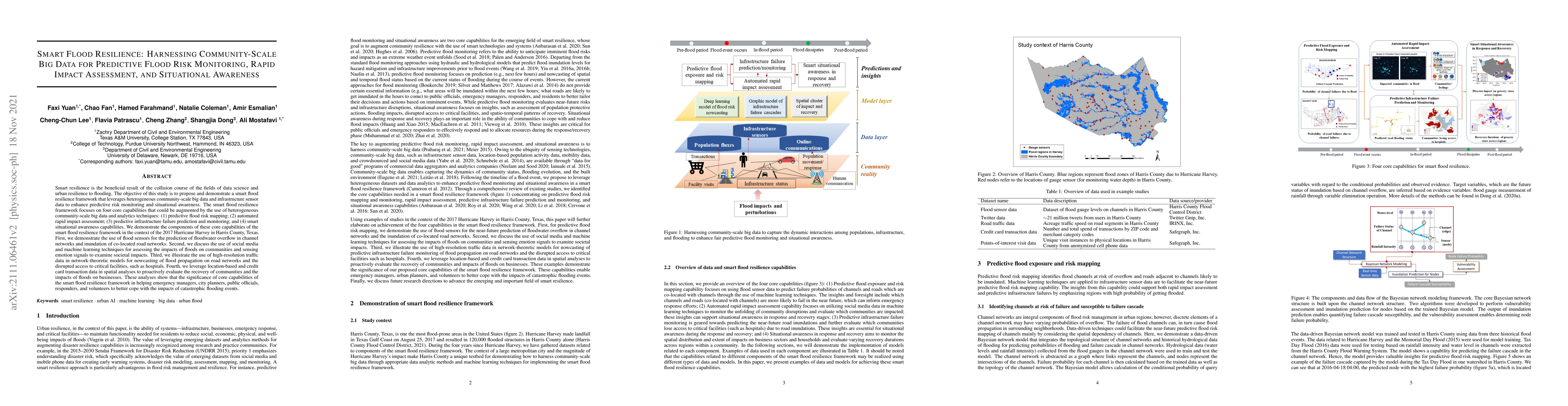
Smart resilience is the beneficial result of the collision course of the fields of data science and urban resilience to flooding. The objective of this study is to propose and demonstrate a smart fl...
The Covid-19 has presented an unprecedented challenge to public health worldwide. However, residents in different countries showed diverse levels of Covid-19 awareness during the outbreak and suffer...
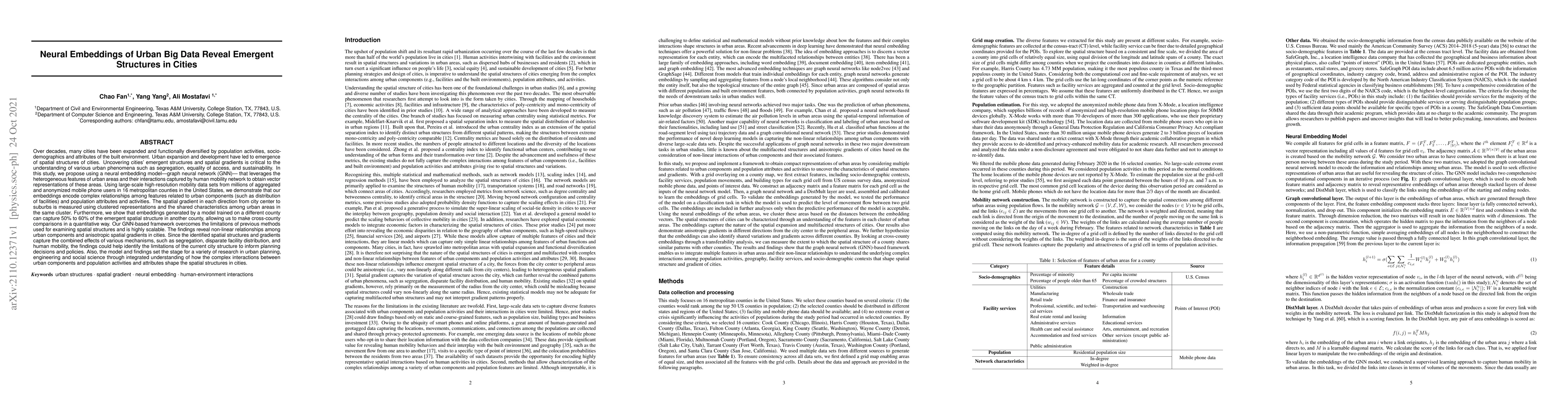
In this study, we propose using a neural embedding model-graph neural network (GNN)- that leverages the heterogeneous features of urban areas and their interactions captured by human mobility networ...
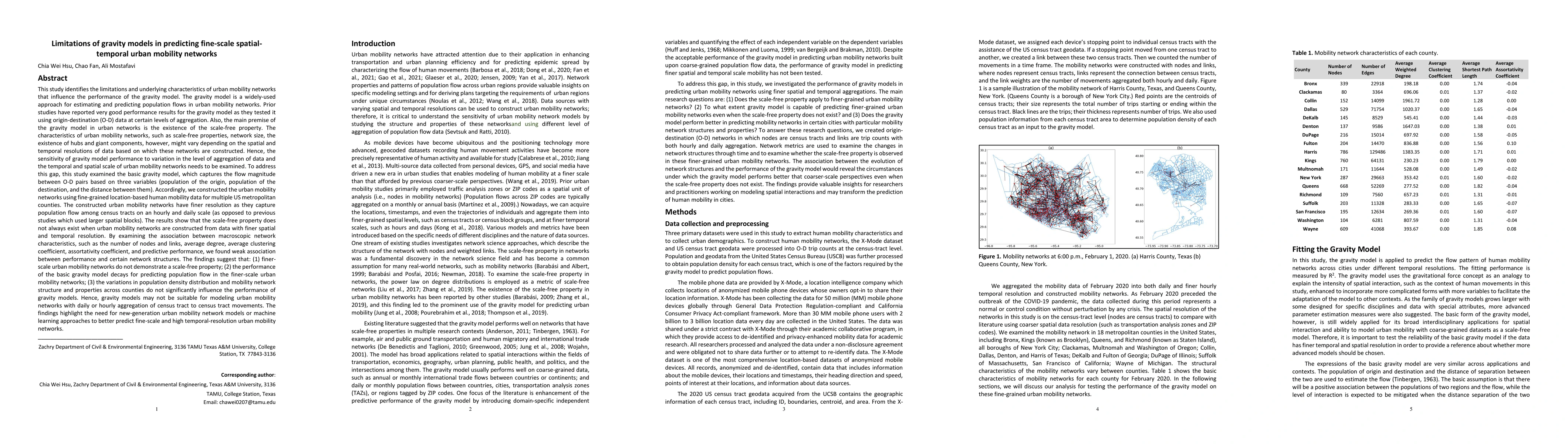
This study identifies the limitations and underlying characteristics of urban mobility networks that influence the performance of the gravity model. The gravity model is a widely-used approach for e...
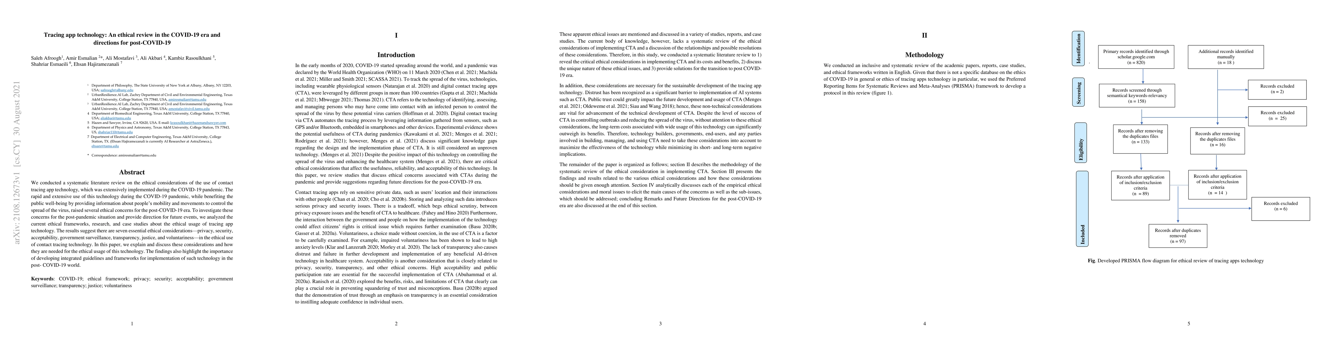
We conducted a systematic literature review on the ethical considerations of the use of contact tracing app technology, which was extensively implemented during the COVID-19 pandemic. The rapid and ...
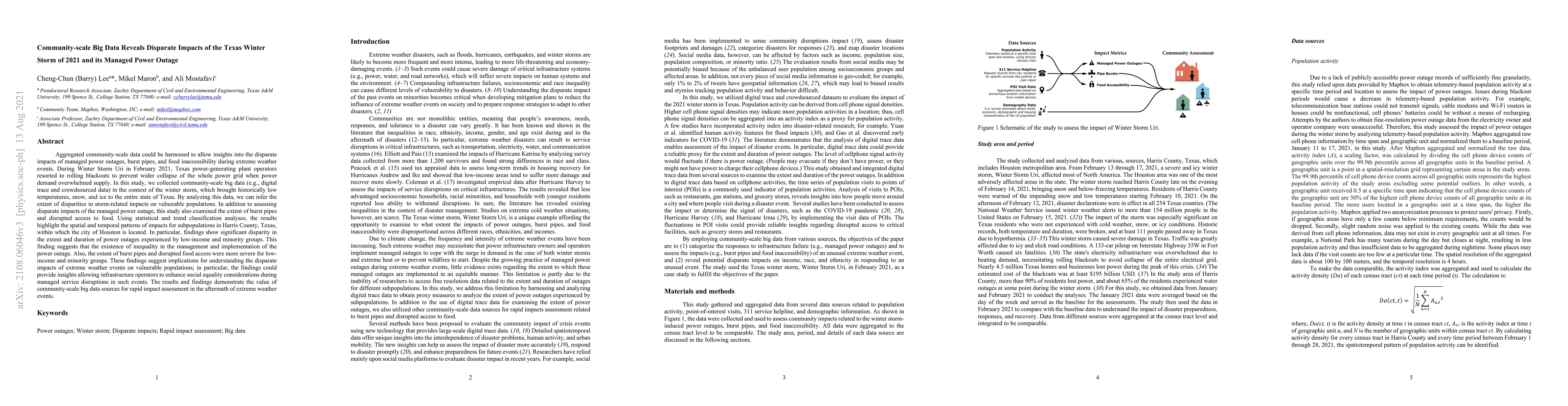
Aggregated community-scale data could be harnessed to allow insights into the disparate impacts of managed power outages, burst pipes, and food inaccessibility during extreme weather events. During ...
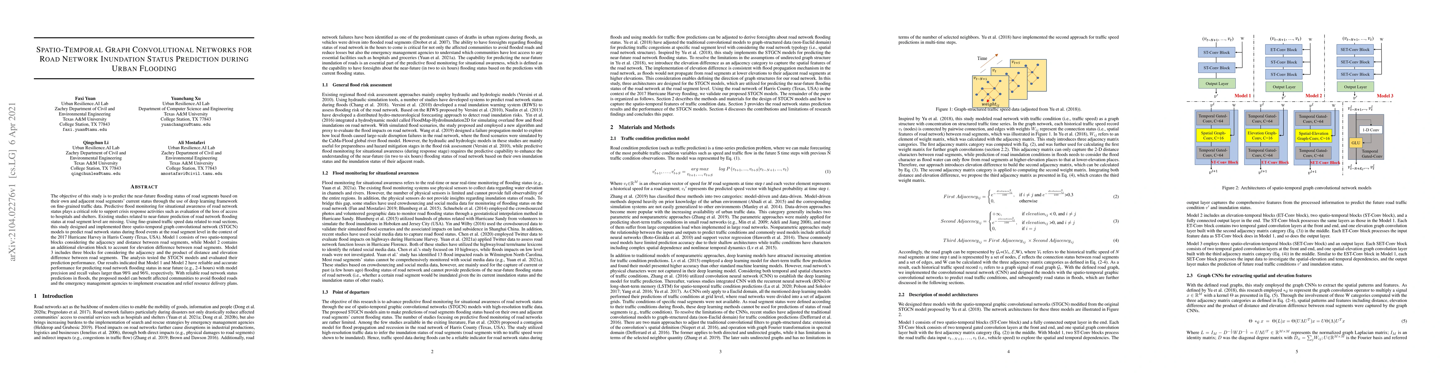
The objective of this study is to predict the near-future flooding status of road segments based on their own and adjacent road segments current status through the use of deep learning framework on ...
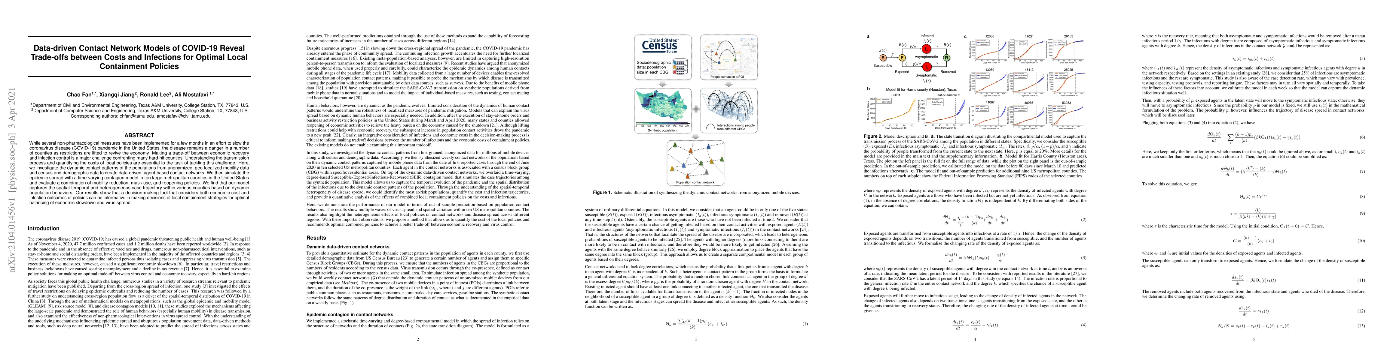
While several non-pharmacological measures have been implemented for a few months in an effort to slow the coronavirus disease (COVID-19) pandemic in the United States, the disease remains a danger ...
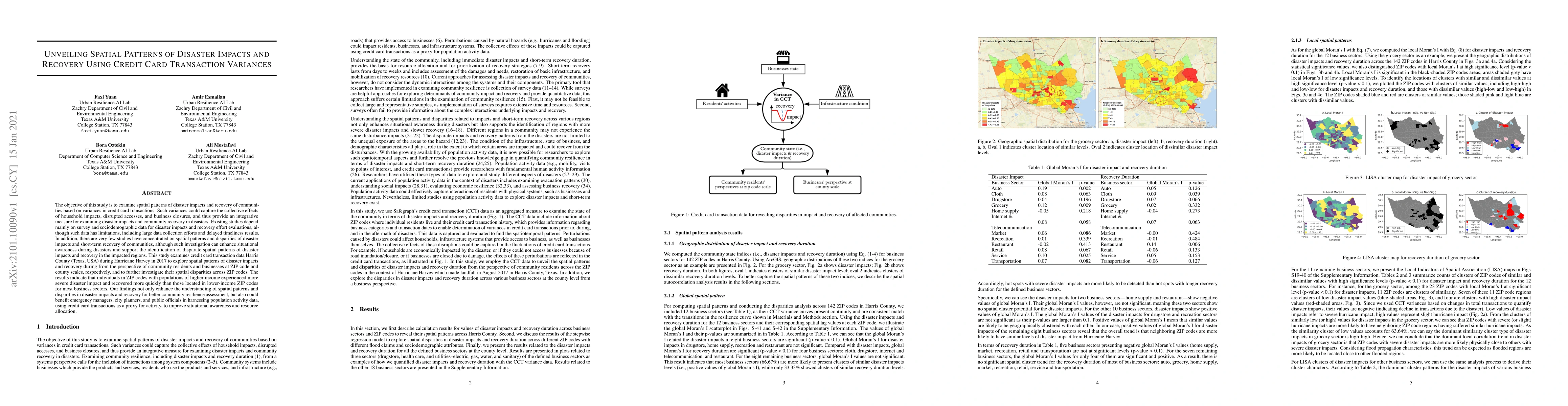
The objective of this study is to examine spatial patterns of impacts and recovery of communities based on variances in credit card transactions. Such variances could capture the collective effects ...
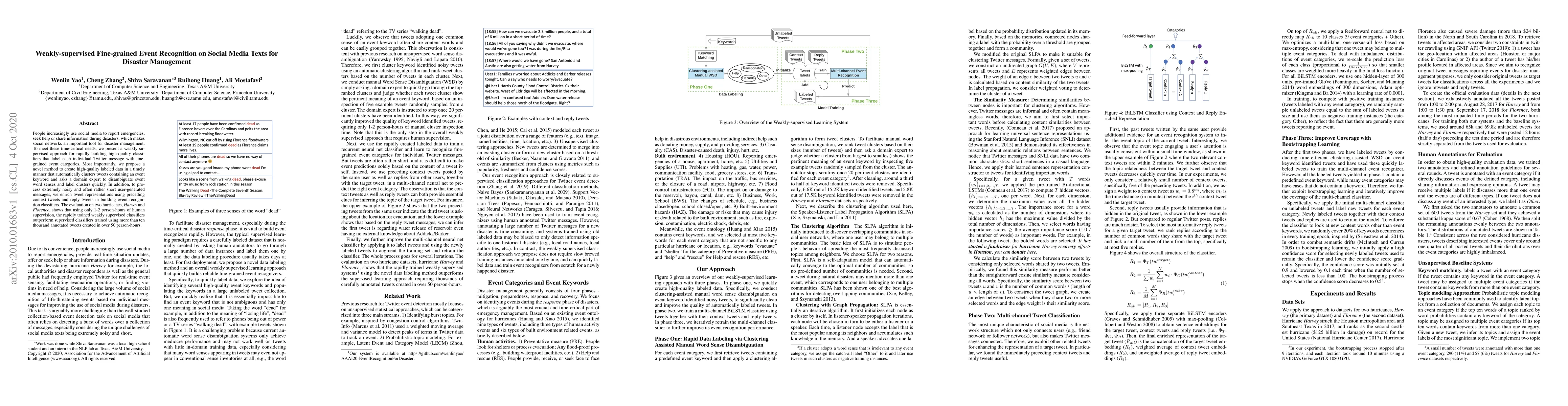
People increasingly use social media to report emergencies, seek help or share information during disasters, which makes social networks an important tool for disaster management. To meet these time...
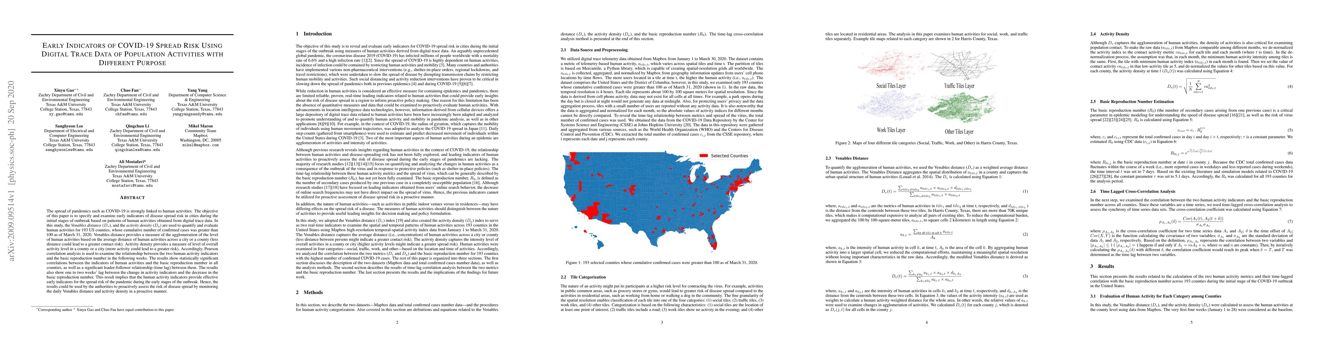
The spread of pandemics such as COVID-19 is strongly linked to human activities. The objective of this paper is to specify and examine early indicators of disease spread risk in cities during the in...
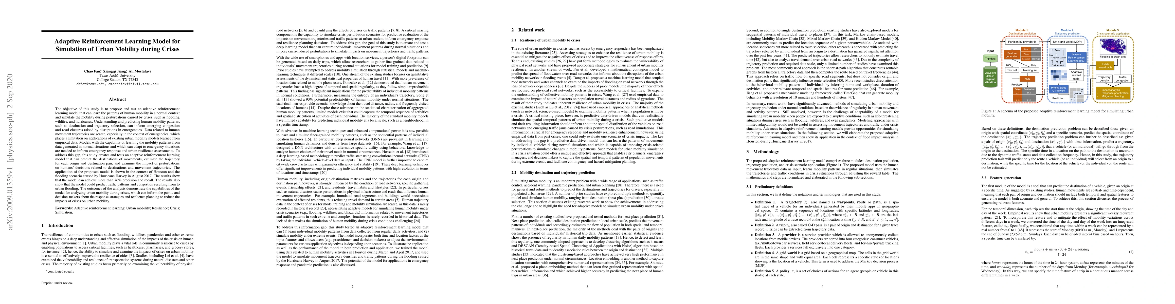
The objective of this study is to propose and test an adaptive reinforcement learning model that can learn the patterns of human mobility in a normal context and simulate the mobility during perturb...
In this paper, we propose a deep learning model to forecast the range of increase in COVID-19 infected cases in future days and we present a novel method to compute equidimensional representations o...
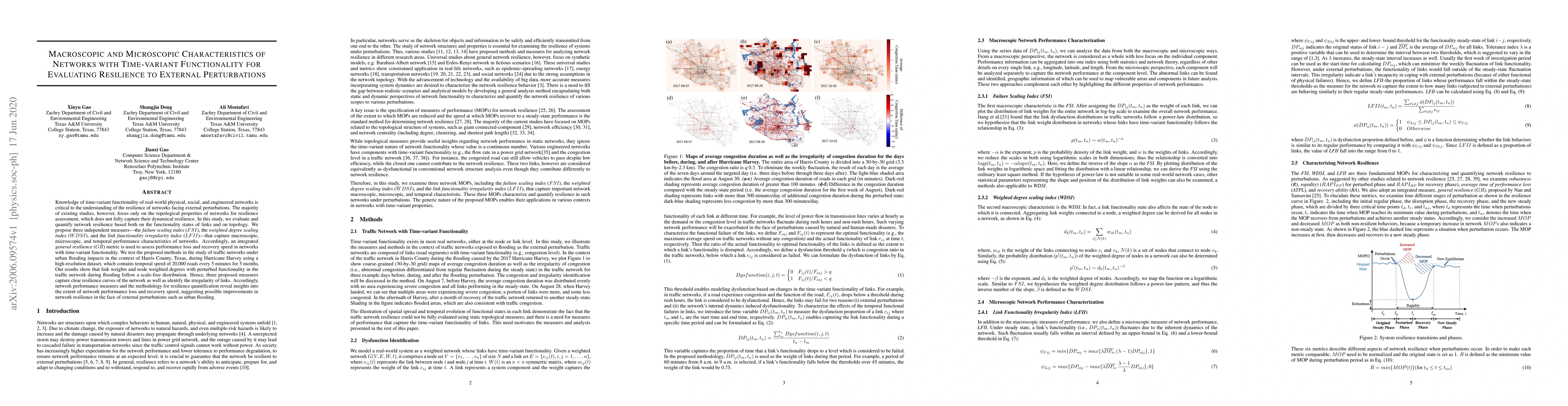
Knowledge of time-variant functionality of real-world physical, social, and engineered networks is critical to the understanding of the resilience of networks facing external perturbations. The majo...
The rapid spread of COVID-19 in the United States has imposed a major threat to public health, the real economy, and human well-being. With the absence of effective vaccines, the preventive actions ...
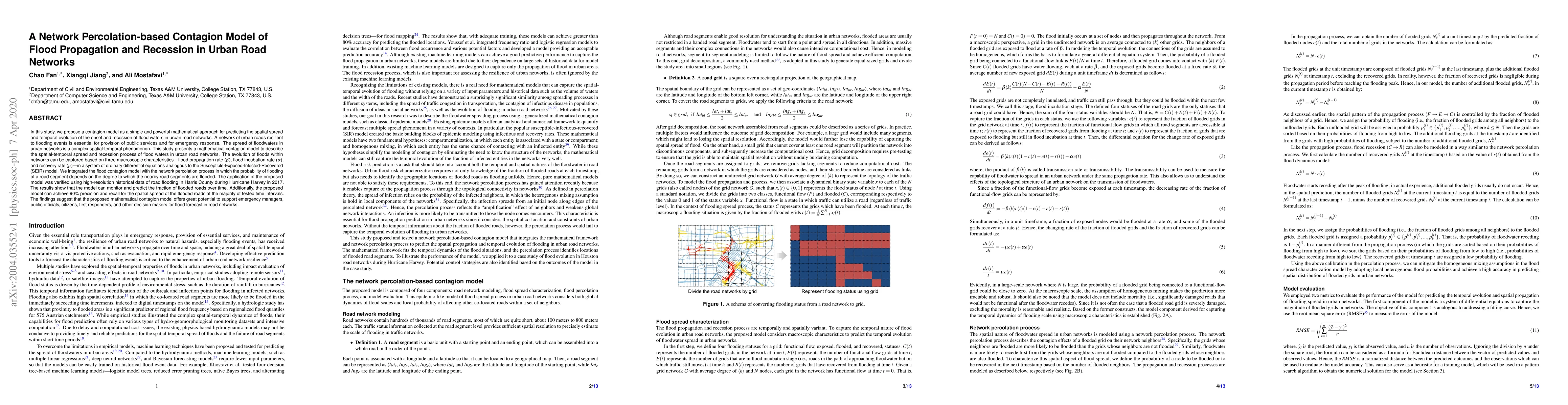
In this study, we propose a contagion model as a simple and powerful mathematical approach for predicting the spatial spread and temporal evolution of the onset and recession of flood waters in urba...
High-resolution flood probability maps are essential for addressing the limitations of existing flood risk assessment approaches but are often limited by the availability of historical event data. Als...
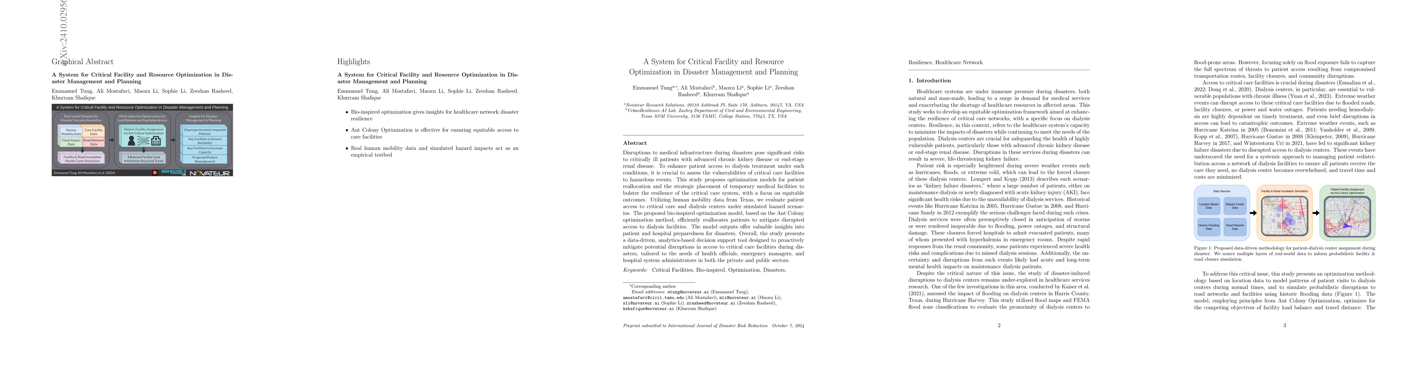
Disruptions to medical infrastructure during disasters pose significant risks to critically ill patients with advanced chronic kidney disease or end-stage renal disease. To enhance patient access to d...
Power outages have become increasingly frequent, intense, and prolonged in the US due to climate change, aging electrical grids, and rising energy demand. However, largely due to the absence of granul...
The recovery of businesses after a disaster is vital to community economic resilience, yet the network dynamics influencing the speed and spillover effects of recovery remain poorly understood. Unders...
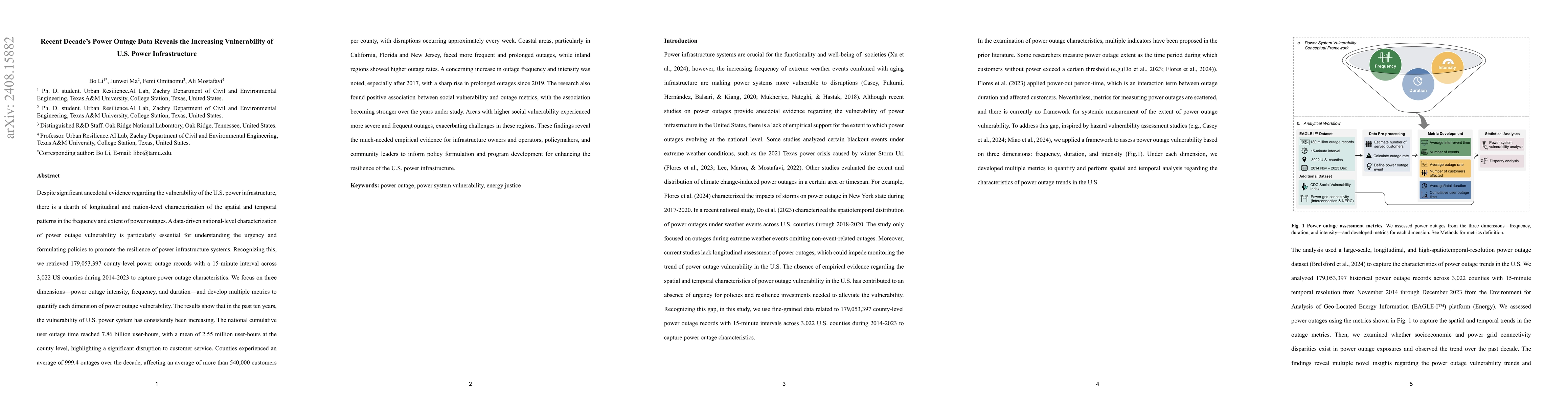
Despite significant anecdotal evidence regarding the vulnerability of the U.S. power infrastructure, there is a dearth of longitudinal and nation-level characterization of the spatial and temporal pat...
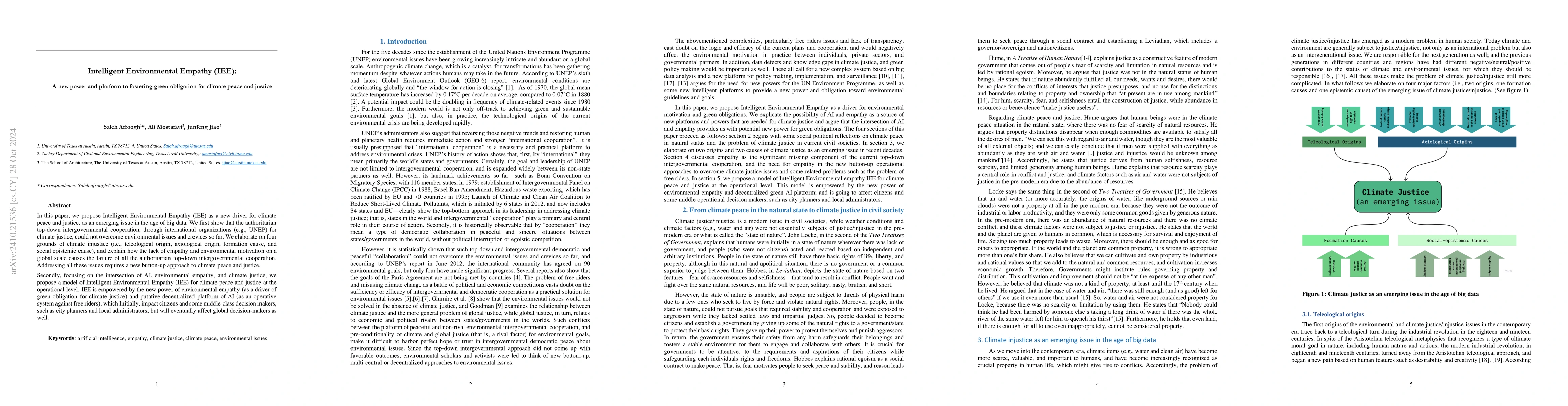
In this paper, we propose Intelligent Environmental Empathy (IEE) as a new driver for climate peace and justice, as an emerging issue in the age of big data. We first show that the authoritarian top-d...
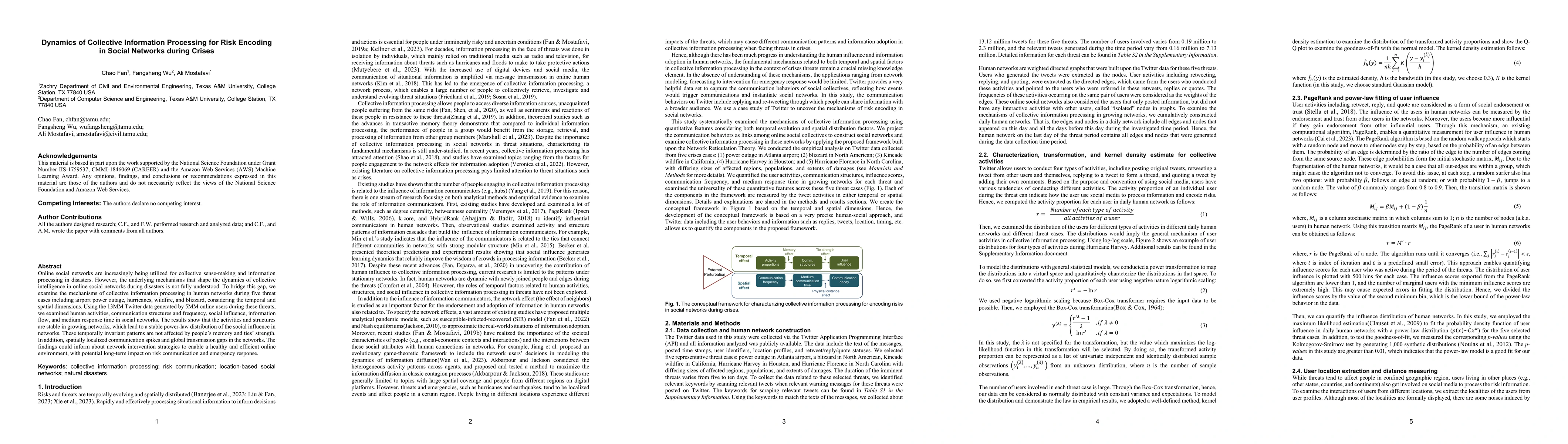
Online social networks are increasingly being utilized for collective sense making and information processing in disasters. However, the underlying mechanisms that shape the dynamics of collective int...
The Phase-Field Method (PFM) is employed to simulate two-phase flows, with the fully-coupled Cahn- Hilliard-Navier-Stokes (CHNS) equations governing the temporal evolution of the flow. The methodology...
This study investigates the spatial patterns and temporal variations in outage duration, intensity, and restoration/recovery following the 2024 Hurricane Beryl in Houston, Texas. This historic blackou...
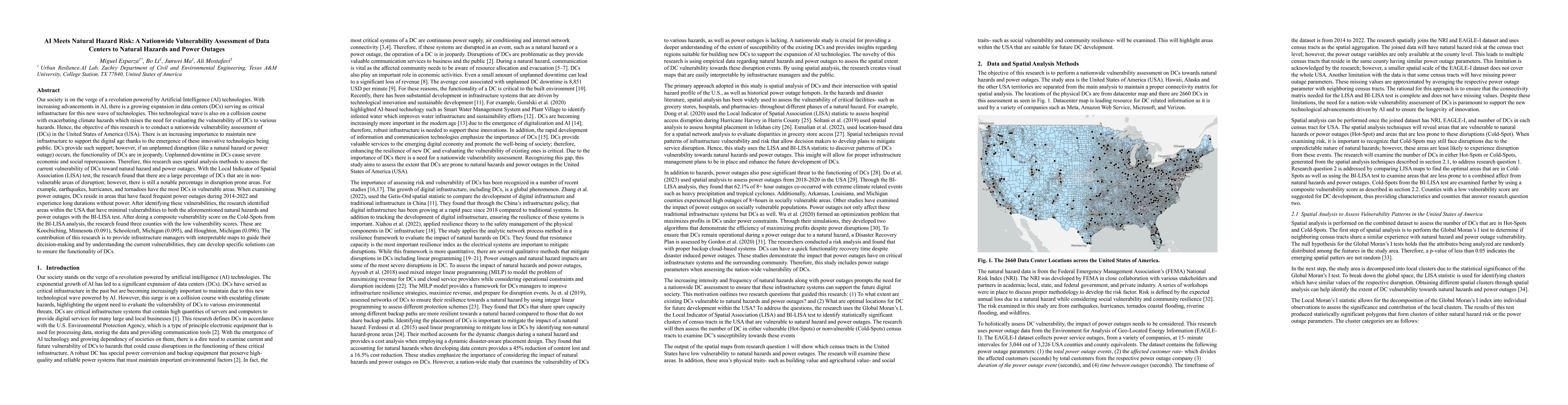
Our society is on the verge of a revolution powered by Artificial Intelligence (AI) technologies. With increasing advancements in AI, there is a growing expansion in data centers (DCs) serving as crit...
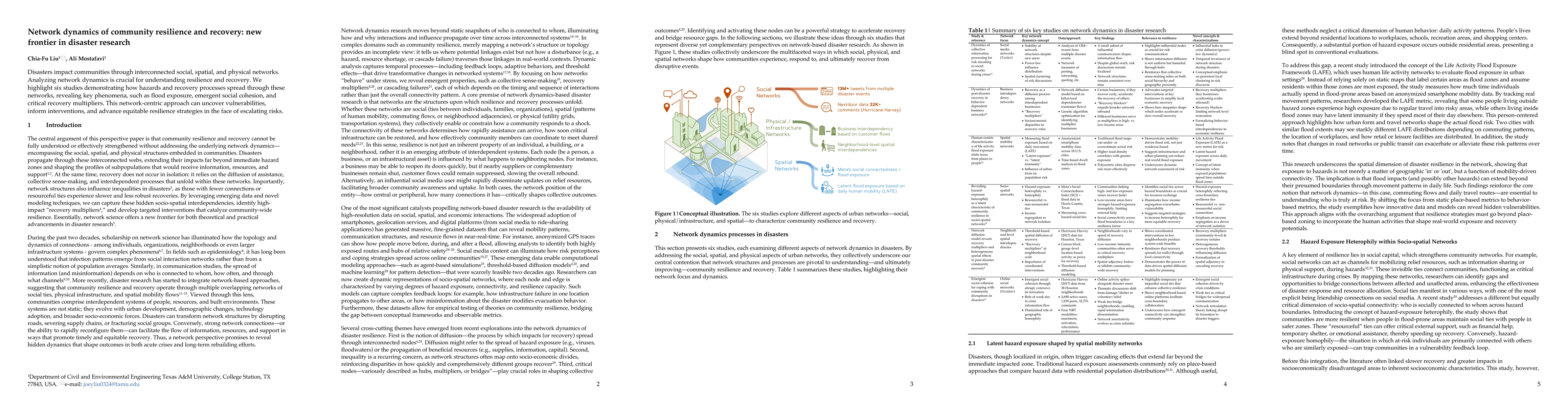
Disasters impact communities through interconnected social, spatial, and physical networks. Analyzing network dynamics is crucial for understanding resilience and recovery. We highlight six studies de...
Natural disasters increasingly threaten communities worldwide, creating an urgent need for rapid, reliable building damage assessment to guide emergency response and recovery efforts. Current methods ...
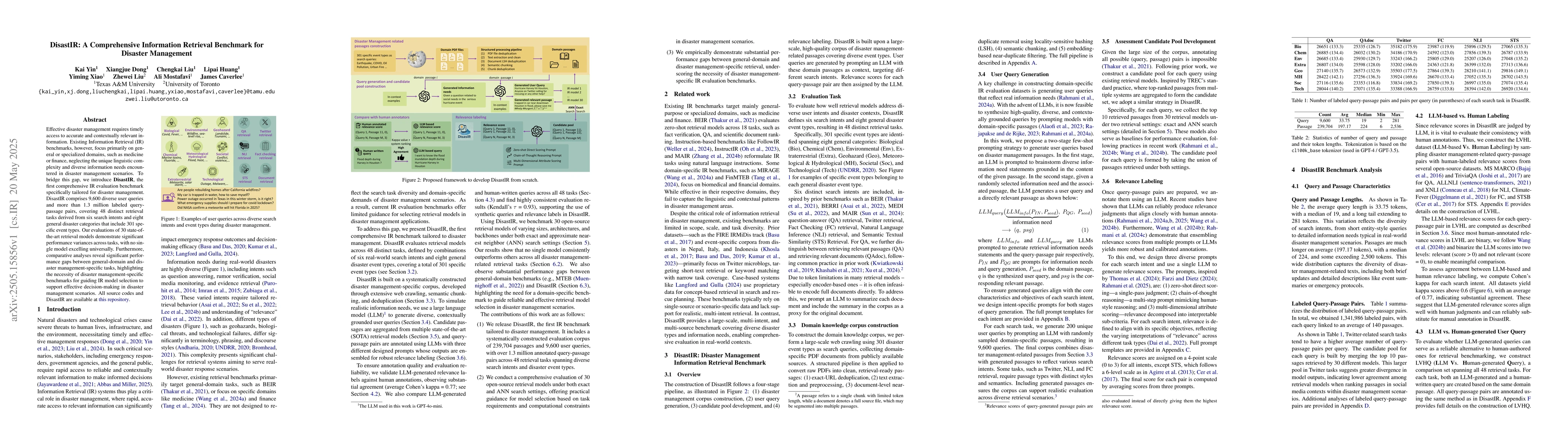
Effective disaster management requires timely access to accurate and contextually relevant information. Existing Information Retrieval (IR) benchmarks, however, focus primarily on general or specializ...
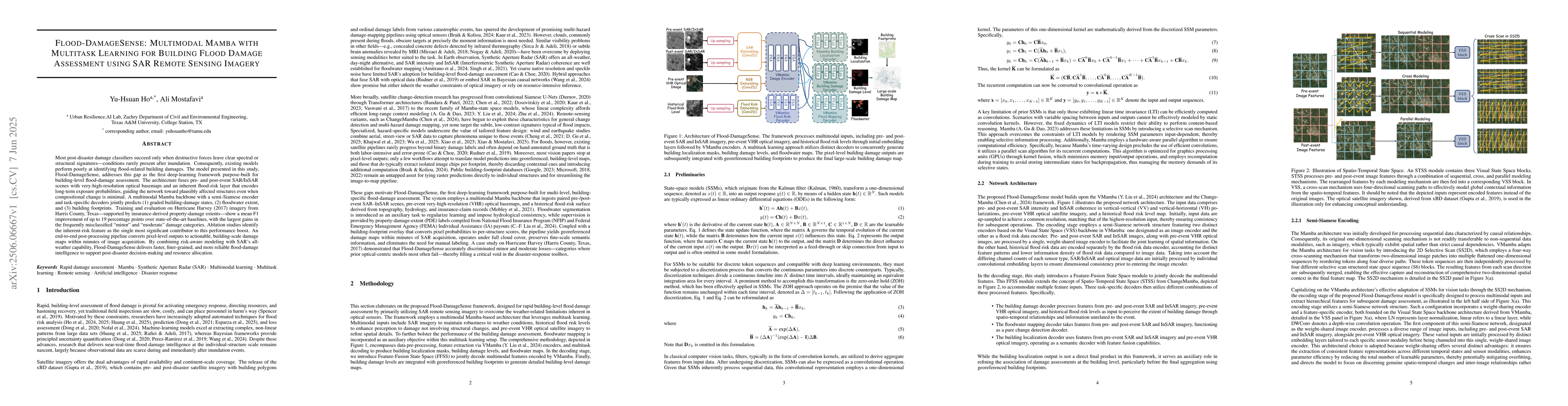
Most post-disaster damage classifiers succeed only when destructive forces leave clear spectral or structural signatures -- conditions rarely present after inundation. Consequently, existing models pe...
Systems for the generation and distribution of electrical power represents critical infrastructure and, when extreme weather events disrupt such systems, this imposes substantial costs on consumers. T...
Evacuation is critical for disaster safety, yet agencies lack timely, accurate, and transparent tools for evacuation prediction. This study introduces Evac-Cast, an interpretable machine learning fram...
The multifaceted nature of disaster impact shows that densely populated areas contribute more to aggregate burden, while sparsely populated but heavily affected regions suffer disproportionately at th...
Disasters frequently exceed established hazard models, revealing blind spots where unforeseen impacts and vulnerabilities hamper effective response. This perspective paper contends that situational aw...
The escalating intensity and frequency of wildfires demand innovative computational methods for rapid and accurate property damage assessment. Traditional methods are often time consuming, while moder...
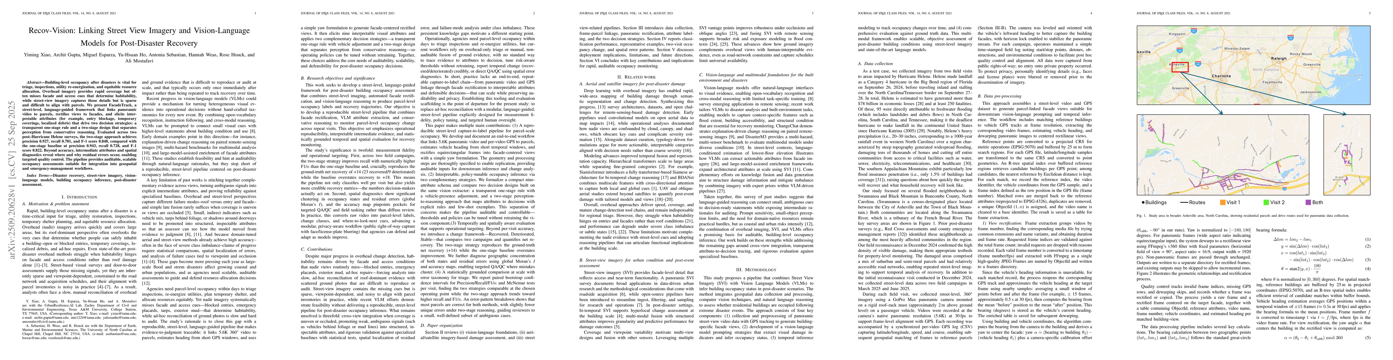
Building-level occupancy after disasters is vital for triage, inspections, utility re-energization, and equitable resource allocation. Overhead imagery provides rapid coverage but often misses facade ...
Effective and efficient access to relevant information is essential for disaster management. However, no retrieval model is specialized for disaster management, and existing general-domain models fail...
The escalating frequency and severity of disasters routinely overwhelm traditional response capabilities, exposing critical vulnerability in disaster management. Current practices are hindered by frag...
Disaster-induced power outages create cascading disruptions across urban lifelines, yet the timed coupling between grid failure and essential service access remains poorly quantified. Focusing on Hurr...
Current wildfire risk assessments rely on coarse hazard maps and opaque machine learning models that optimize regional accuracy while sacrificing interpretability at the decision scale. WildfireGenome...
This work improves upon our previously introduced explicit dynamic modal filter (DEMF) within the framework of the discontinuous Galerkin spectral element method (DGSEM) by introducing a mechanism for...
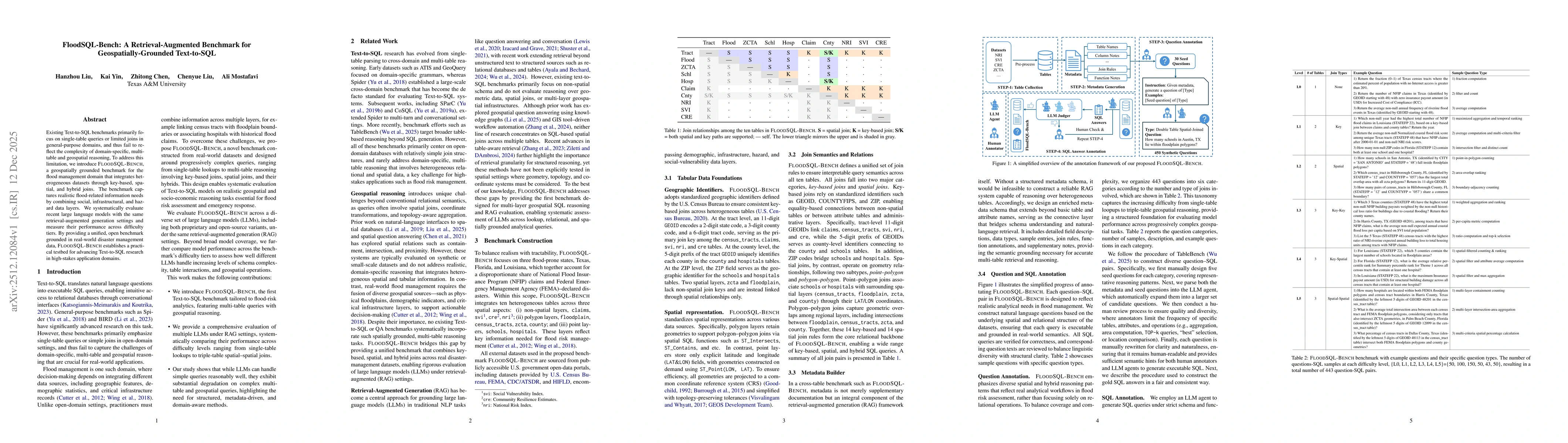
Existing Text-to-SQL benchmarks primarily focus on single-table queries or limited joins in general-purpose domains, and thus fail to reflect the complexity of domain-specific, multi-table and geospat...
Lifeline infrastructure underpins the continuity of daily life, yet conventional criticality assessments remain largely asset-centric, inferring importance from physical capacity or network topology r...
Flash flood warnings are largely reactive, providing limited advance notice for evacuation planning and resource prepositioning. This study presents and validates an anticipatory, parametric framework...
As wildfires increasingly evolve into urban conflagrations, traditional risk models that treat structures as isolated assets fail to capture the non-linear contagion dynamics characteristic of the wil...
Accurate question answering (QA) in disaster management requires reasoning over uncertain and conflicting information, a setting poorly captured by existing benchmarks built on clean evidence. We intr...
Timely and spatially resolved disaster impact assessment is essential for effective emergency response. However, automated methods typically struggle with temporal asynchrony. Real-time human reports ...
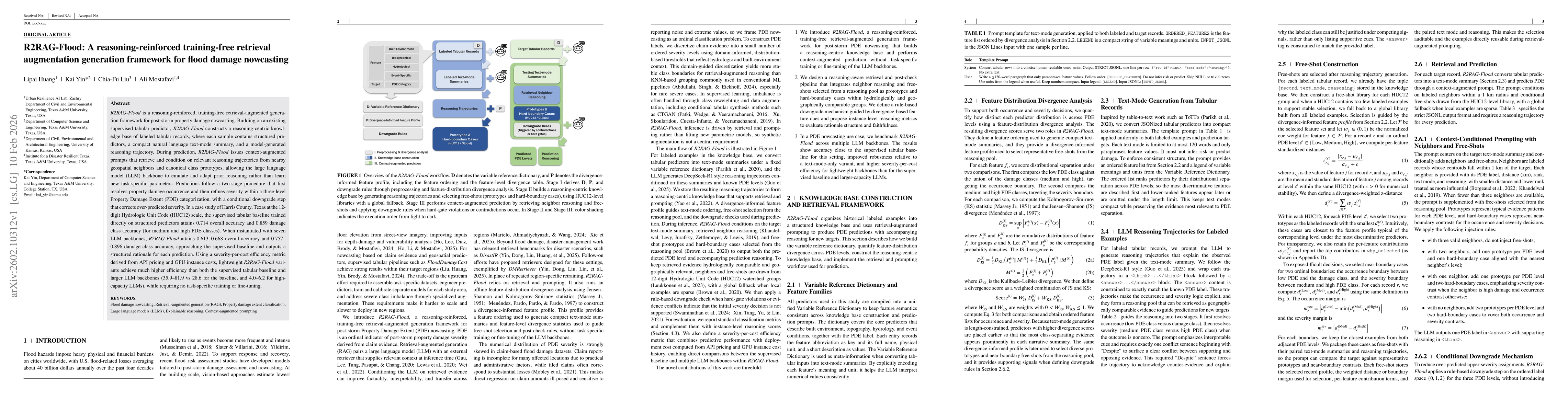
R2RAG-Flood is a reasoning-reinforced, training-free retrieval-augmented generation framework for post-storm property damage nowcasting. Building on an existing supervised tabular predictor, the frame...
This paper argues that AI-enabled analysis of street-view imagery, complemented by performance-gated machine-learning imputation, provides a viable pathway for generating building-specific elevation d...
Effective disaster management requires rapid access to information distributed across structured operational records, unstructured institutional documents, and dynamic external sources. However, most ...
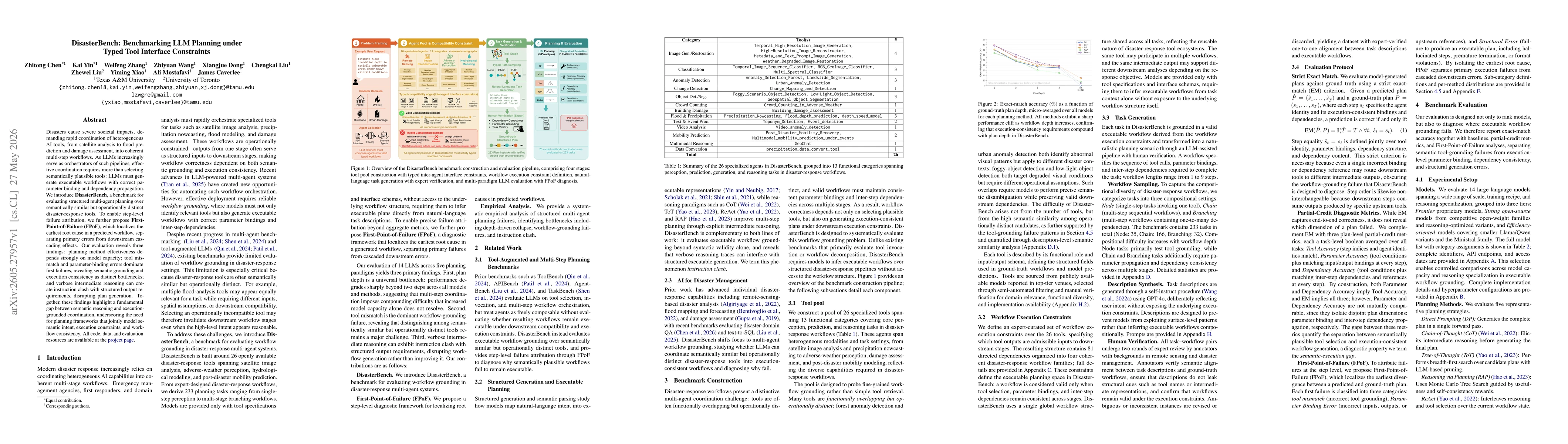
Disasters cause severe societal impacts, demanding rapid coordination of heterogeneous AI tools, from satellite analysis to flood prediction and damage assessment, into coherent multi-step workflows. ...
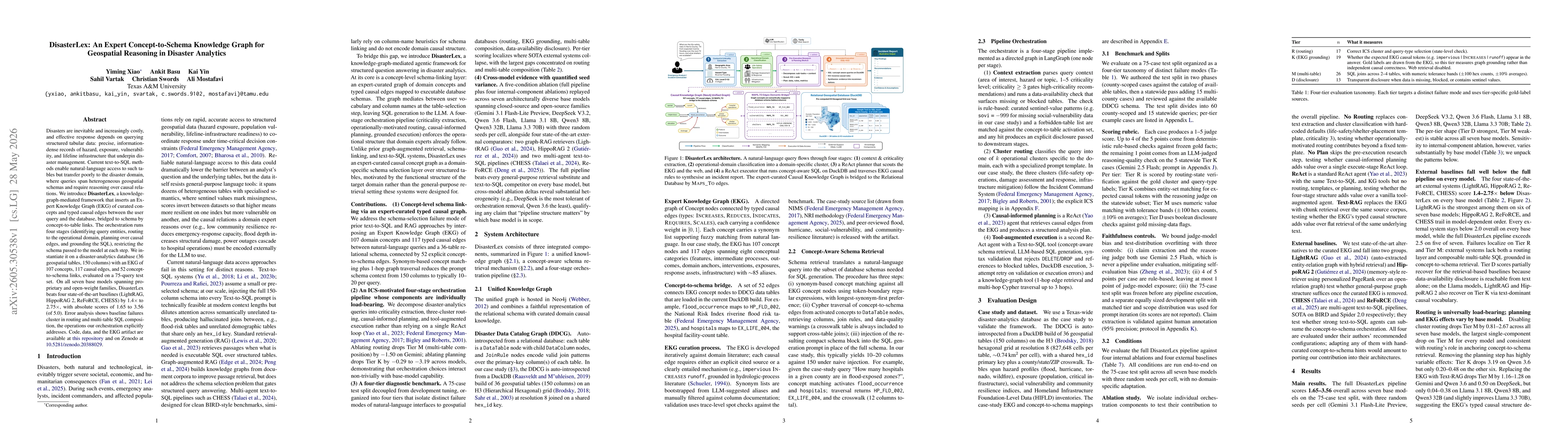
Disasters are inevitable and increasingly costly, and effective response depends on querying structured tabular data: precise, information-dense records of hazard, exposure, vulnerability, and lifelin...
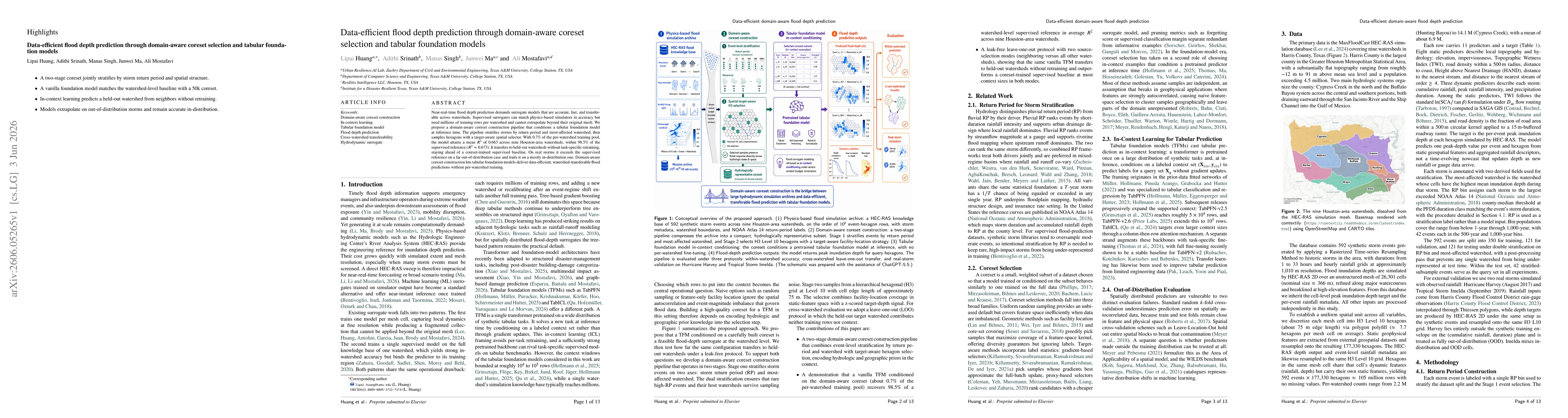
Near-real-time flood depth prediction demands surrogate models that are accurate, fast, and transferable across watersheds. Supervised surrogates can match physics-based simulators in accuracy but nee...
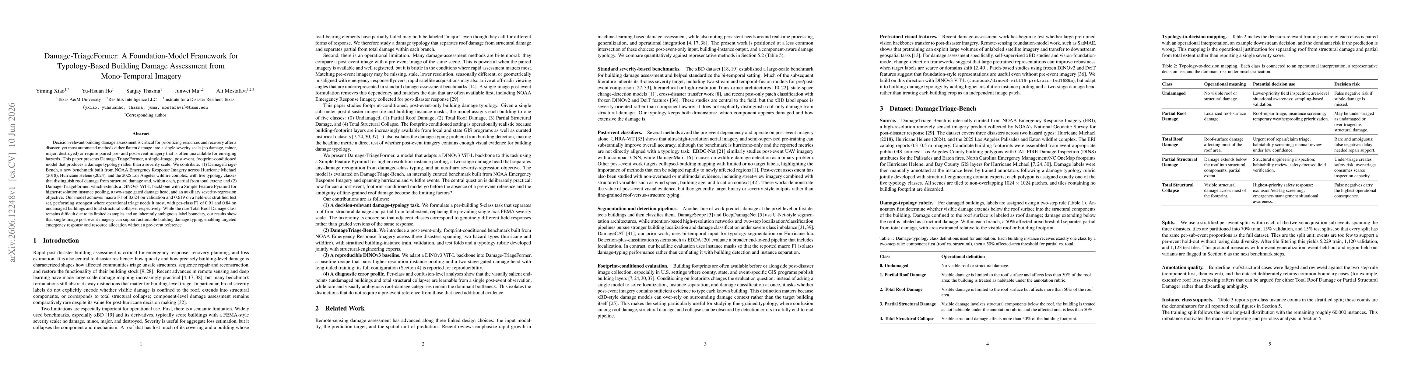
Decision-relevant building damage assessment is critical for prioritizing resources and recovery after a disaster, yet most automated methods either flatten damage into a single severity scale (no dam...
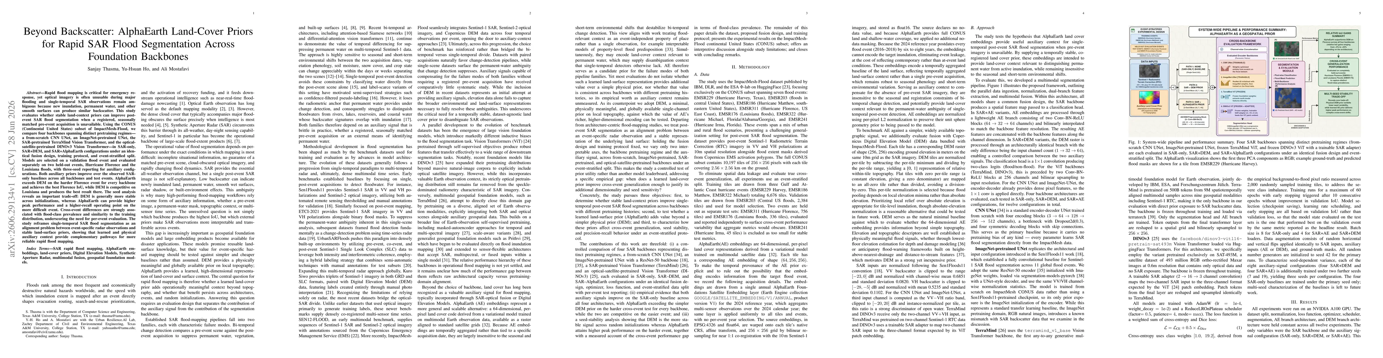
Rapid flood mapping is critical for emergency response, yet optical imagery is often unusable during major flooding and single-temporal SAR is ambiguous, since new inundation, permanent water, and oth...