ELEV-VISION-SAM: Integrated Vision Language and Foundation Model for Automated Estimation of Building Lowest Floor Elevation
Publication
Metrics
AI Quick Summary
ELEV-VISION-SAM integrates vision language models with image segmentation to improve automated estimation of building lowest floor elevation (LFE) from street view imagery, enhancing availability from 33% to 56% by distinguishing front doors more effectively, and establishing a new baseline for street view image-based LFE estimation.
Paper Preview
Abstract
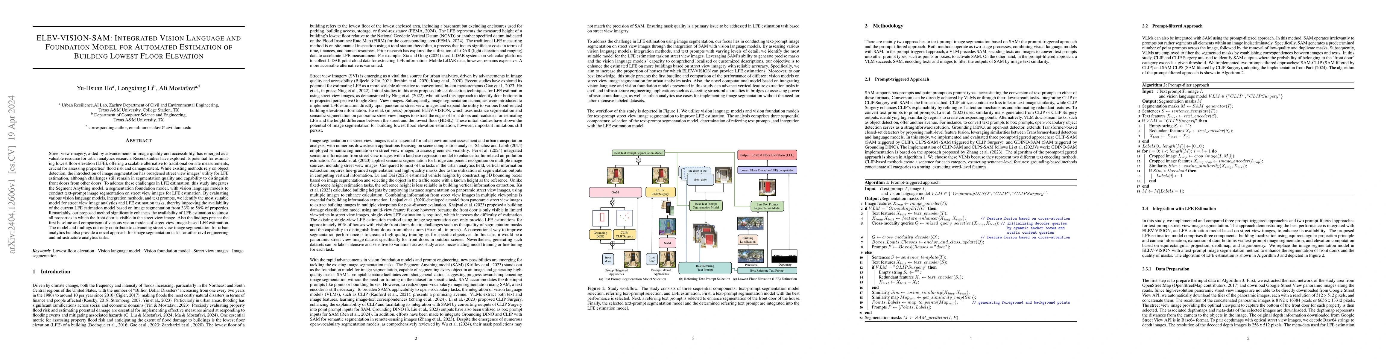
Street view imagery, aided by advancements in image quality and accessibility, has emerged as a valuable resource for urban analytics research. Recent studies have explored its potential for estimating lowest floor elevation (LFE), offering a scalable alternative to traditional on-site measurements, crucial for assessing properties' flood risk and damage extent. While existing methods rely on object detection, the introduction of image segmentation has broadened street view images' utility for LFE estimation, although challenges still remain in segmentation quality and capability to distinguish front doors from other doors. To address these challenges in LFE estimation, this study integrates the Segment Anything model, a segmentation foundation model, with vision language models to conduct text-prompt image segmentation on street view images for LFE estimation. By evaluating various vision language models, integration methods, and text prompts, we identify the most suitable model for street view image analytics and LFE estimation tasks, thereby improving the availability of the current LFE estimation model based on image segmentation from 33% to 56% of properties. Remarkably, our proposed method significantly enhances the availability of LFE estimation to almost all properties in which the front door is visible in the street view image. Also the findings present the first baseline and comparison of various vision models of street view image-based LFE estimation. The model and findings not only contribute to advancing street view image segmentation for urban analytics but also provide a novel approach for image segmentation tasks for other civil engineering and infrastructure analytics tasks.
AI Key Findings
Get AI-generated insights about this paper's methodology, results, significance, and more — seven facets brought into focus.
Impact
Paper Details
Authors
PDF Preview
Key Terms
Citation Network
Current paper (gray), citations (green), references (blue)
Display is limited for performance on very large graphs.
Discussion 0