Summary

Accurate land cover classification from satellite imagery is crucial in environmental monitoring and sustainable resource management. However, it remains challenging due to the complexity of natural landscapes, the visual similarity between classes, and the significant class imbalance in the 
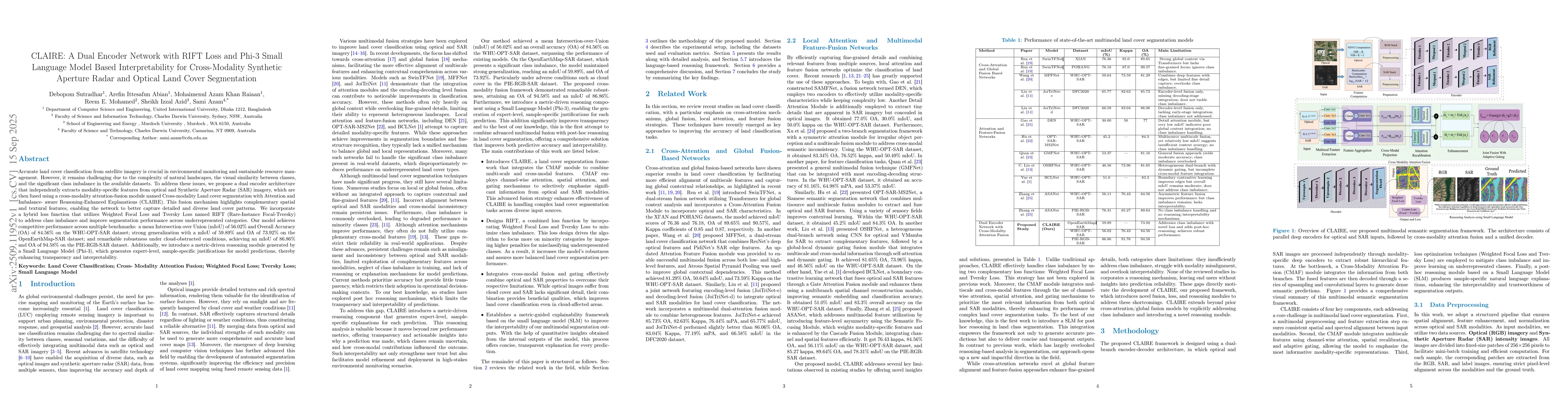
available datasets. To address these issues, we propose a dual encoder architecture that independently extracts modality-specific features from optical and Synthetic Aperture Radar (SAR) imagery, which are then fused using a cross-modality attention-fusion module named Cross-modality Land cover segmentation with Attention and Imbalance-aware Reasoning-Enhanced Explanations (CLAIRE). This fusion mechanism highlights complementary spatial and textural features, enabling the network to better capture detailed and diverse land cover patterns. We incorporate a hybrid loss function that utilizes Weighted Focal Loss and Tversky Loss named RIFT (Rare-Instance Focal-Tversky) to address class imbalance and improve segmentation performance across underrepresented categories. Our model achieves competitive performance across multiple benchmarks: a mean Intersection over Union (mIoU) of 56.02% and Overall Accuracy (OA) of 84.56% on the WHU-OPT-SAR dataset; strong generalization with a mIoU of 59.89% and OA of 73.92% on the OpenEarthMap-SAR dataset; and remarkable robustness under cloud-obstructed conditions, achieving an mIoU of 86.86% and OA of 94.58% on the PIE-RGB-SAR dataset. Additionally, we introduce a metric-driven reasoning module generated by a Small Language Model (Phi-3), which generates expert-level, sample-specific justifications for model predictions, thereby enhancing transparency and interpretability.

AI Key Findings

Generated Oct 02, 2025

Methodology

The research employs a cross-modal segmentation approach combining optical and SAR data, utilizing a dual-encoder architecture with Cross-Modality Attention Fusion (CMAF) module and RIFT loss function for class imbalance handling.

Key Results

  • CLAIRE achieves 76.04% validation Dice, 62.87% mIoU, and 75.76% OA on WHU-OPT-SAR dataset
  • The RIFT loss outperforms existing methods with 56.02% mIoU, 72.79% Dice, and 24.02% rare class IoU
  • The method maintains high segmentation quality under cloud-covered conditions with 77.04% Dice on cloud-contaminated RGB inputs

Significance

This research advances remote sensing by enabling robust land cover segmentation in challenging real-world conditions, with implications for environmental monitoring, disaster response, and urban planning.

Technical Contribution

Proposes RIFT loss function combining weighted focal and Tversky losses, along with CMAF module for adaptive cross-modal feature fusion in remote sensing segmentation

Novelty

Introduces a metric-driven interpretability framework using Phi-3 SLM for explainable multimodal segmentation, along with dual-encoder architecture for modality-specific feature extraction

Limitations

  • Dual-stream design and attention-heavy fusion module increase computational overhead
  • RIFT's fixed hyperparameters may require tuning for unseen distributions
  • Interpretability module relies on pre-engineered prompts without interactive feedback

Future Work

  • Explore model compression and lightweight distillation for resource optimization
  • Investigate adaptive hyperparameter tuning for diverse datasets
  • Develop interactive reasoning frameworks with user feedback mechanisms
  • Extend to include registration correction modules for misaligned data

Paper Details

PDF Preview

Download PDF

Comments (0)

This website uses cookies to ensure you get the best experience. Learn more