ArxivLens

Publication

Published: Feb 25, 2025
Categories: cs.CV, cs.LG, eess.IV

Metrics

Source: ArXiv

AI Quick Summary

This study employs convolutional neural networks (CNNs) to enhance mineral prospecting via remote sensing data analysis, demonstrating their superiority over traditional machine learning models in mapping alteration zones in Broken Hill, Australia. Landsat 9 and ASTER data are particularly effective, highlighting CNNs' potential for precise geological mapping.

Quick Answers

What is "Convolutional neural networks for mineral prospecting through alteration mapping with remote sensing data" about?

This study employs convolutional neural networks (CNNs) to enhance mineral prospecting via remote sensing data analysis, demonstrating their superiority over traditional machine learning models in mapping alteration zones in Broken Hill, Australia. Landsat 9 and ASTER data are particularly effective, highlighting CNNs' potential for precise geological mapping.

What methodology did the authors use?

This study employs convolutional neural networks (CNNs) alongside KNN, SVM, and MLP machine learning models to map alteration zones using Landsat 8, Landsat 9, and ASTER remote sensing datasets. Ground truth and PCA-based training datasets are utilized for model training, with performance metrics such as accuracy and F1 score evaluated. More in Methodology →

What are the key results?

CNNs slightly outperform conventional models in capturing spatial patterns, especially with ground truth-based training. — Landsat 9 outperforms Landsat 8 in mapping iron oxide areas using ground truth-trained CNNs. More in Key Results →

Why is this work significant?

The research highlights the potential of CNNs in remotesensing data processing for geological studies, offering enhanced accuracy and efficiency, particularly in critical mineral exploration. More in Significance →

What are the main limitations?

The study acknowledges the challenge of validating remotesensing outputs through deep learning, requiring comprehensive ground truth datasets for reliable verification. — The methodology may not generalize well to other geological settings with complex spatial patterns or diverse datasets. More in Limitations →

Paper Preview

Abstract

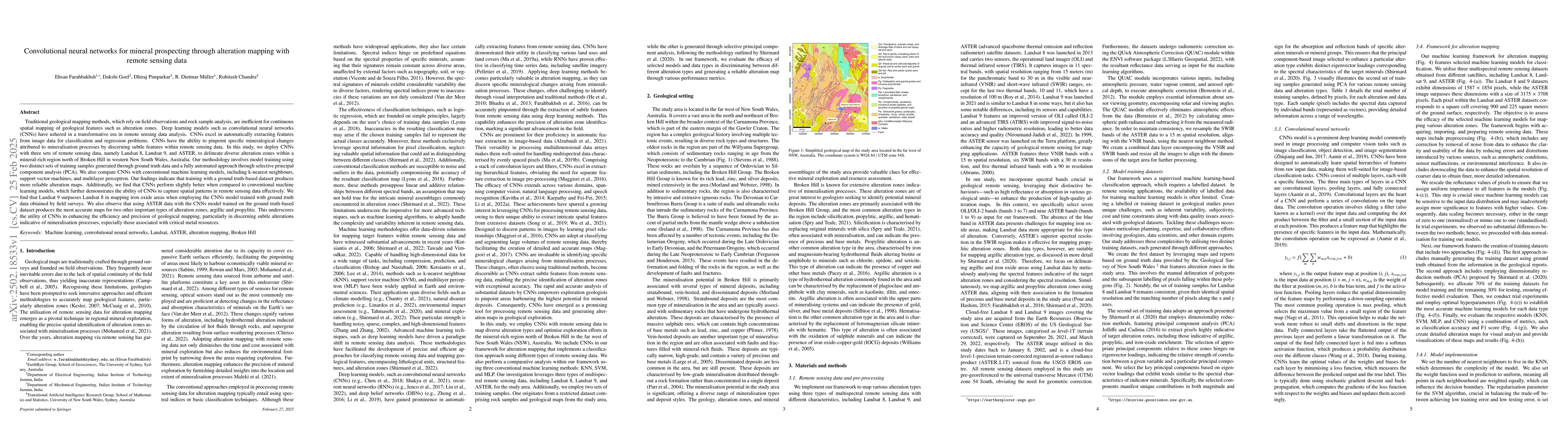
Traditional geological mapping, based on field observations and rock sample analysis, is inefficient for continuous spatial mapping of features like alteration zones. Deep learning models, such as convolutional neural networks (CNNs), have revolutionised remote sensing data analysis by automatically extracting features for classification and regression tasks. CNNs can detect specific mineralogical changes linked to mineralisation by identifying subtle features in remote sensing data. This study uses CNNs with Landsat 8, Landsat 9, and ASTER data to map alteration zones north of Broken Hill, New South Wales, Australia. The model is trained using ground truth data and an automated approach with selective principal component analysis (PCA). We compare CNNs with traditional machine learning models, including k-nearest neighbours, support vector machines, and multilayer perceptron. Results show that ground truth-based training yields more reliable maps, with CNNs slightly outperforming conventional models in capturing spatial patterns. Landsat 9 outperforms Landsat 8 in mapping iron oxide areas using ground truth-trained CNNs, while ASTER data provides the most accurate argillic and propylitic alteration maps. This highlights CNNs' effectiveness in improving geological mapping precision, especially for identifying subtle mineralisation-related alterations.

Key Findings, in focus

Seven facets of this paper, analysed and brought into focus by AI.

AI-generated · verify against source Generated Jun 11, 2025
In focus · one-line synthesis

The research highlights the potential of CNNs in remotesensing data processing for geological studies, offering enhanced accuracy and efficiency, particularly in critical mineral exploration.

01
MethodologyHow they did it

This study employs convolutional neural networks (CNNs) alongside KNN, SVM, and MLP machine learning models to map alteration zones using Landsat 8, Landsat 9, and ASTER remote sensing datasets. Ground truth and PCA-based training datasets are utilized for model training, with performance metrics such as accuracy and F1 score evaluated.

02
ResultsWhat they found
  • CNNs slightly outperform conventional models in capturing spatial patterns, especially with ground truth-based training.
  • Landsat 9 outperforms Landsat 8 in mapping iron oxide areas using ground truth-trained CNNs.
  • ASTER data provides the most accurate argillic and propylitic alteration maps.
  • PCA-based training datasets increase the number of training samples, leading to higher overall accuracy and F1 scores compared to ground truth-based samples, except for CNNs with ASTER data.
03
SignificanceWhy it matters

The research highlights the potential of CNNs in remotesensing data processing for geological studies, offering enhanced accuracy and efficiency, particularly in critical mineral exploration.

04
Technical ContributionsWhat's new technically

The development of a machine learning framework for mapping alteration zones using CNNs, KNN, SVM, and MLP, demonstrating improved accuracy and efficiency compared to traditional methods.

05
NoveltyWhat sets it apart

This work stands out by applying CNNs to remote sensing data for geological alteration mapping, showcasing their capability to extract features and handle spatial information effectively.

06
LimitationsWhat to be cautious about
  • The study acknowledges the challenge of validating remotesensing outputs through deep learning, requiring comprehensive ground truth datasets for reliable verification.
  • The methodology may not generalize well to other geological settings with complex spatial patterns or diverse datasets.
07
Future WorkWhere it goes next
  • Exploration of crowd-sourcing as a potential solution to the challenge of validating remotesensing outputs.
  • Further refinement of the alteration mapping framework with more data and open-source software improvements.

Impact

85
References

Paper Details

Paper ID: 2502.18533
Categories:
cs.CV cs.LG eess.IV

How to Cite This Paper

Reference manager: RIS EndNote

Citation Network

Current paper (gray), citations (green), references (blue)

Display is limited for performance on very large graphs.

Current Paper
Citations
References
Click to view


Discussion 0

This website uses cookies to ensure you get the best experience. Learn more