The research introduces DeepAndes, a transformer-based vision foundation model trained on three million multi-spectral satellite images, specifically for Andean archaeology using a customized DINOv2 self-supervised learning algorithm.
DeepAndes: A Self-Supervised Vision Foundation Model for Multi-Spectral Remote Sensing Imagery of the Andes
Publication
Metrics
AI Quick Summary
DeepAndes is a transformer-based foundation model for multi-spectral remote sensing imagery tailored for Andean archaeology, leveraging self-supervised learning on 8-band satellite data. It outperforms conventional models in few-shot learning scenarios for classification, retrieval, and segmentation tasks.
Quick Answers
What is "DeepAndes: A Self-Supervised Vision Foundation Model for Multi-Spectral Remote Sensing Imagery of the Andes" about?
DeepAndes is a transformer-based foundation model for multi-spectral remote sensing imagery tailored for Andean archaeology, leveraging self-supervised learning on 8-band satellite data. It outperforms conventional models in few-shot learning scenarios for classification, retrieval, and segmentation tasks.
What methodology did the authors use?
The research introduces DeepAndes, a transformer-based vision foundation model trained on three million multi-spectral satellite images, specifically for Andean archaeology using a customized DINOv2 self-supervised learning algorithm. More in Methodology →
What are the key results?
DeepAndes outperforms models trained from scratch or pre-trained on smaller datasets in imbalanced image classification, image instance retrieval, and pixel-level semantic segmentation tasks. — Superior F1 scores, mean average precision, and Dice scores achieved by DeepAndes in few-shot learning scenarios. More in Key Results →
Why is this work significant?
This research is important as it provides a tailored deep learning solution for archaeologists to map sites at large scales using multi-spectral remote sensing data, offering unique insights into long-term demographic trends, social networks, and past climate adaptations. More in Significance →
What are the main limitations?
The study focuses on the Andean region, so generalizability to other geographical areas might be limited. — Performance evaluation is based on specific archaeological tasks; broader applicability across various remote sensing domains remains to be explored. More in Limitations →
Abstract
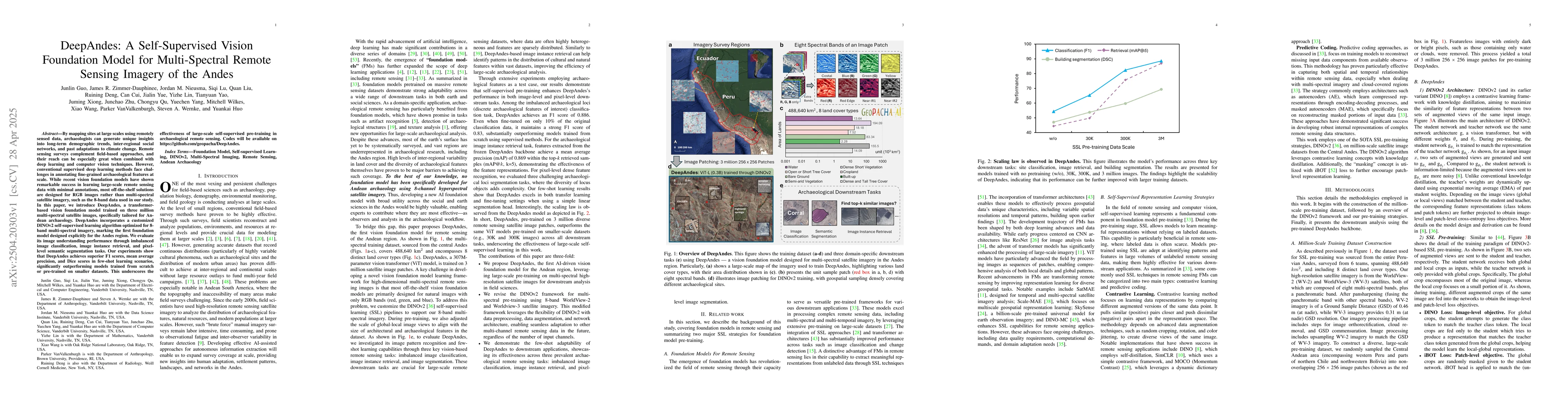
By mapping sites at large scales using remotely sensed data, archaeologists can generate unique insights into long-term demographic trends, inter-regional social networks, and past adaptations to climate change. Remote sensing surveys complement field-based approaches, and their reach can be especially great when combined with deep learning and computer vision techniques. However, conventional supervised deep learning methods face challenges in annotating fine-grained archaeological features at scale. While recent vision foundation models have shown remarkable success in learning large-scale remote sensing data with minimal annotations, most off-the-shelf solutions are designed for RGB images rather than multi-spectral satellite imagery, such as the 8-band data used in our study. In this paper, we introduce DeepAndes, a transformer-based vision foundation model trained on three million multi-spectral satellite images, specifically tailored for Andean archaeology. DeepAndes incorporates a customized DINOv2 self-supervised learning algorithm optimized for 8-band multi-spectral imagery, marking the first foundation model designed explicitly for the Andes region. We evaluate its image understanding performance through imbalanced image classification, image instance retrieval, and pixel-level semantic segmentation tasks. Our experiments show that DeepAndes achieves superior F1 scores, mean average precision, and Dice scores in few-shot learning scenarios, significantly outperforming models trained from scratch or pre-trained on smaller datasets. This underscores the effectiveness of large-scale self-supervised pre-training in archaeological remote sensing. Codes will be available on https://github.com/geopacha/DeepAndes.
Key Findings, in focus
Seven facets of this paper, analysed and brought into focus by AI.
This research is important as it provides a tailored deep learning solution for archaeologists to map sites at large scales using multi-spectral remote sensing data, offering unique insights into long-term demographic trends, social networks, and past climate adaptations.
- DeepAndes outperforms models trained from scratch or pre-trained on smaller datasets in imbalanced image classification, image instance retrieval, and pixel-level semantic segmentation tasks.
- Superior F1 scores, mean average precision, and Dice scores achieved by DeepAndes in few-shot learning scenarios.
- Demonstrates the effectiveness of large-scale self-supervised pre-training in archaeological remote sensing.
This research is important as it provides a tailored deep learning solution for archaeologists to map sites at large scales using multi-spectral remote sensing data, offering unique insights into long-term demographic trends, social networks, and past climate adaptations.
DeepAndes, a transformer-based self-supervised vision foundation model optimized for 8-band multi-spectral imagery, marks the first foundation model designed explicitly for the Andes region.
This work is novel as it addresses the challenge of fine-grained archaeological feature annotation in multi-spectral remote sensing imagery by employing large-scale self-supervised pre-training with a customized DINOv2 algorithm.
- The study focuses on the Andean region, so generalizability to other geographical areas might be limited.
- Performance evaluation is based on specific archaeological tasks; broader applicability across various remote sensing domains remains to be explored.
- Explore the applicability of DeepAndes in other geographical regions and remote sensing domains.
- Investigate the integration of DeepAndes with other archaeological data sources for comprehensive analysis.
Impact
Authors
PDF Preview
Citation Network
Current paper (gray), citations (green), references (blue)
Display is limited for performance on very large graphs.
Discussion 0