ArxivLens

Quick Summary:

DeepForest uses high-resolution aerial images and synthetic-aperture imaging to penetrate deep into dense vegetation, overcoming the limitations of traditional remote sensing. It employs 3D convolutional neural networks to reduce out-of-focus signals and generate volumetric reflectance stacks, offering insights into plant health and ecosystem dynamics.

arXiv Id: 2502.02171
Date Published: 2025-02-04
Date Updated: 2025-02-04

Categories:

Key Terms (TF-IDF):

No key terms available for this paper.

Summary:

Access to below-canopy volumetric vegetation data is crucial for understanding ecosystem dynamics. We address the long-standing limitation of remote sensing to penetrate deep into dense canopy layers. LiDAR and radar are currently considered the primary options for measuring 3D vegetation structures, while cameras can only extract the reflectance and depth of top layers. Using conventional, high-resolution aerial images, our approach allows sensing deep into self-occluding vegetation volumes, such as forests. It is similar in spirit to the imaging process of wide-field microscopy, but can handle much larger scales and strong occlusion. We scan focal stacks by synthetic-aperture imaging with drones and reduce out-of-focus signal contributions using pre-trained 3D convolutional neural networks. The resulting volumetric reflectance stacks contain low-frequency representations of the vegetation volume. Combining multiple reflectance stacks from various spectral channels provides insights into plant health, growth, and environmental conditions throughout the entire vegetation volume.
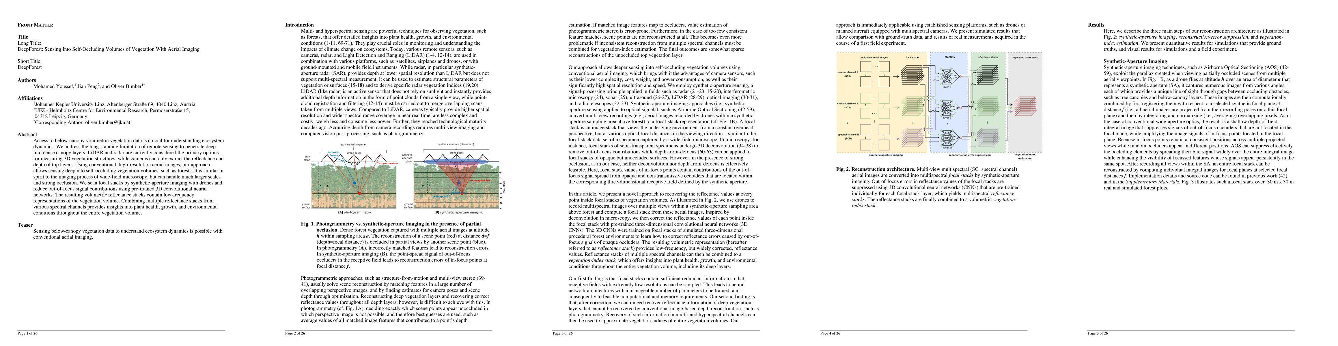
Citation & Reference Network Visualization

This graph shows how this paper is connected to other research. The current paper is shown in dark gray, papers that cite it are in green, and papers it references are in blue. You can:

Current Paper
Papers citing this work (Citations)
Papers cited by this work (References)

• Hover over any node to see the paper title

• Click a node to view that paper's details

• Drag nodes to rearrange the graph

• Use the zoom controls (bottom right) to zoom in/out

Citations and References

No citations found for this paper.

Similar Papers

Multi-Layer Modeling of Dense Vegetation from Aerial LiDAR Scans

Loic Landrieu, Clément Mallet, Ekaterina Kalinicheva, Nesrine Chehata

Published: 2022-04-26

Fusion of Single and Integral Multispectral Aerial Images

Oliver Bimber, Mohamed Youssef

Published: 2024-02-15

Aerial Interaction with Tactile Sensing

Sebastian Scherer, Guanya Shi, Xiaofeng Guo, Junyi Geng, Mohammadreza Mousaei, Guanqi He

Published: 2023-10-03

Comments (0)

This website uses cookies to ensure you get the best experience. Learn more