This paper introduces two new satellite datasets, SAT-4 and SAT-6, and proposes a Deep Belief Network-based classification framework that outperforms existing state-of-the-art algorithms in satellite image classification, achieving accuracies of 97.95% and 93.9% respectively. The study also highlights the benefits of unsupervised learning over traditional supervised methods.
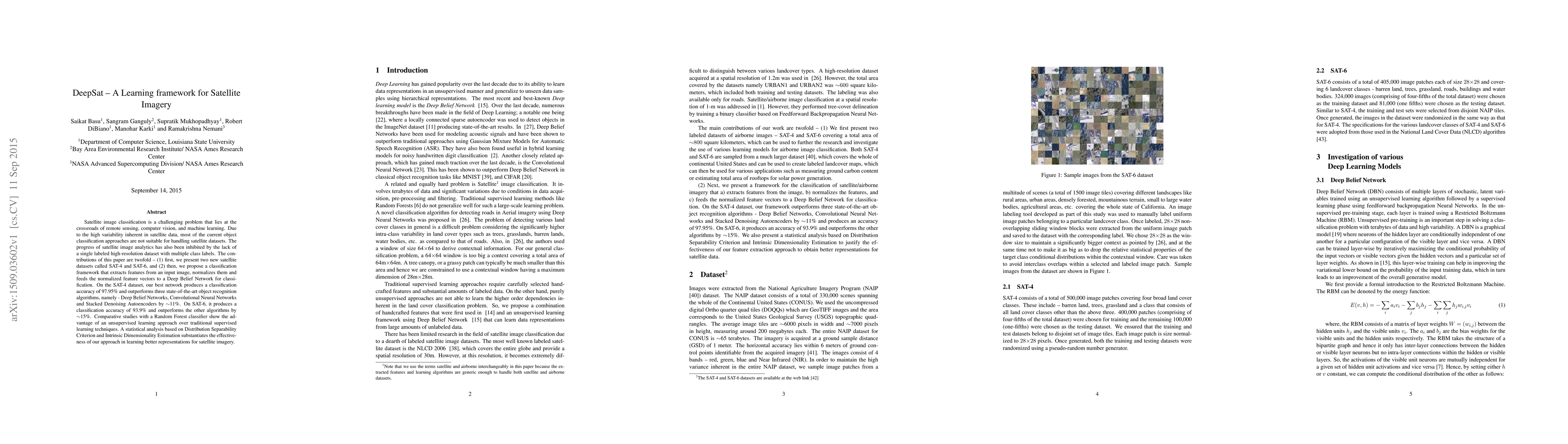
Satellite image classification is a challenging problem that lies at the crossroads of remote sensing, computer vision, and machine learning. Due to the high variability inherent in satellite data, most of the current object classification approaches are not suitable for handling satellite datasets. The progress of satellite image analytics has also been inhibited by the lack of a single labeled high-resolution dataset with multiple class labels. The contributions of this paper are twofold - (1) first, we present two new satellite datasets called SAT-4 and SAT-6, and (2) then, we propose a classification framework that extracts features from an input image, normalizes them and feeds the normalized feature vectors to a Deep Belief Network for classification. On the SAT-4 dataset, our best network produces a classification accuracy of 97.95% and outperforms three state-of-the-art object recognition algorithms, namely - Deep Belief Networks, Convolutional Neural Networks and Stacked Denoising Autoencoders by ~11%. On SAT-6, it produces a classification accuracy of 93.9% and outperforms the other algorithms by ~15%. Comparative studies with a Random Forest classifier show the advantage of an unsupervised learning approach over traditional supervised learning techniques. A statistical analysis based on Distribution Separability Criterion and Intrinsic Dimensionality Estimation substantiates the effectiveness of our approach in learning better representations for satellite imagery.
Get AI-generated insights about this paper's methodology, results, and significance.
Current paper (gray), citations (green), references (blue)
Title | Authors | Year | Actions |
---|---|---|---|
Discovery of isopentenyl flavonoids with inhibitory activity against hepatocellular carcinoma cells based on DeepSAT
|
Qing Wang, Ben-Song Xin, Wen-Long Kou, Li-Na Gao, Gu-Xue Zhang, Yan-Jiao Qiao, Guo-Dong Yao, Xiao-Xiao Huang, Shao-Jiang Song
|
2025
|
View Paper |
Semantic Segmentation for Simultaneous Crop and Land Cover Land Use Classification Using Multi-Temporal Landsat Imagery
|
Saman Ebrahimi, Saurav Kumar
|
2025
|
View Paper |
GNN-ARG: A Graph Neural Network-based Framework for Predicting Antibiotic Resistance Genes
|
Mohd Manzar Abbas, Amit Ranjan, Supratik Mukhopadhyay, Aixin Hou
|
2024
|
View Paper |
Multispectral Satellite Data Classification Using Rank Correlation Similarity Index and Automatic Labeling Technique
|
Arindom Ain, Minakshi Gogoi, D. Chutia
|
2024
|
View Paper |
Multilayer Evolving Fuzzy Neural Networks With Self-Adaptive Dimensionality Compression for High-Dimensional Data Classification
|
Xiaowei Gu, Qiang Ni, Qiang Shen
|
2024
|
View Paper |
Joint feature selection and classification of low-resolution satellite images using the SAT-6 dataset
|
Rajalaxmi Padhy, S. Dash, Jibitesh Mishra
|
2024
|
View Paper |
Towards Satellite Non-IID Imagery: A Spectral Clustering-Assisted Federated Learning Approach
|
Luyao Zou, Y. Park, Chu Myaet Thwal, Y. Tun, Zhu Han, Choong Seon Hong
|
2024
|
View Paper |
Predicting Fractional Shrub Cover in Heterogeneous Mediterranean Landscapes Using Machine Learning and Sentinel-2 Imagery
|
E. Cherif, Ricardo Lucas, Taha Ait Tchakoucht, I. Gama, Inês Ribeiro, Tiago Domingos, Vânia Proença
|
2024
|
View Paper |
Satellite image classification with neural quantum kernels
|
Pablo Rodriguez-Grasa, Robert Farzan-Rodriguez, Gabriele Novelli, Yue Ban, Mikel Sanz
|
2024
|
View Paper |
EarthGen: Generating the World from Top-Down Views
|
Ansh Sharma, Albert Xiao, Praneet Rathi, Rohit Kundu, Albert J. Zhai, Yuan Shen, Shenlong Wang
|
2024
|
View Paper |
Image Classification CNNs using the FINN Engine for SRAM-based APSoC in Satellite Applications
|
Arthur F. Ely, F. Benevenuti, Guilherme Korol, A. C. S. Beck, J. Azambuja, F. Kastensmidt
|
2024
|
View Paper |
QACDes: QoS-aware context-sensitive design of cyber-physical systems
|
Subhajit Sidhanta, Chanachok Chokwitthaya, Yimin Zhu, Supratik Mukhopadhyay
|
2024
|
View Paper |
Application of time series analysis to improve the validity of Immersive virtual environments for collecting occupant thermal state and adaptive behavioral intention data
|
Girish Rentala, Yimin Zhu, Supratik Mukhopadhyay
|
2024
|
View Paper |
Machine learning for automated classification of lung collagen in a urethane-induced lung injury mouse model
|
K. Alnafisah, Amit Ranjan, Sushant P Sahu, Jianhua Chen, Sarah Alhejji, Alexandra Noël, M. Gartia, Supratik Mukhopadhyay
|
2024
|
View Paper |
Monitoring and regression analysis of landfill surface temperatures using remote sensing and image processing techniques
|
Kislaye Sharma, Meenakshi Sood, Amod Kumar
|
2024
|
View Paper |
Deep learning in cropland field identification: A review
|
Fan Xu, X. Yao, Kangxin Zhang, Hao Yang, Quanlong Feng, Ying Li, Shuai Yan, Bingbo Gao, Shaoshuai Li, Jianyu Yang, Chao Zhang, Yahui Lv, Dehai Zhu, Sijing Ye
|
2024
|
View Paper |
Latent Style-based Quantum GAN for high-quality Image Generation
|
Su Yeon Chang, Supanut Thanasilp, B. L. Saux, S. Vallecorsa, Michele Grossi
|
2024
|
View Paper |
Holdout based blending approaches for improved satellite image classification
|
Suresh Kumar Musali, Rajeshwari Janthakal, Nuvvusetty Rajasekhar
|
2024
|
View Paper |
Generation and classification of patch-based land use and land cover dataset in diverse Indian landscapes: a comparative study of machine learning and deep learning models.
|
N. S. Rengma, Manohar Yadav
|
2024
|
View Paper |
Deep Learning with Spatiotemporal Data: A Deep Dive into GeotorchAI
|
Kanchan Chowdhury, Mohamed Sarwat
|
2024
|
View Paper |
Sub-Band Backdoor Attack in Remote Sensing Imagery
|
Kazi Aminul Islam, Hongyi Wu, Chunsheng Xin, R. Ning, Liuwan Zhu, Jiang Li
|
2024
|
View Paper |
StrideNET: Swin Transformer for Terrain Recognition with Dynamic Roughness Extraction
|
Maitreya Shelare, Neha Shigvan, Atharva Satam, Poonam Sonar
|
2024
|
View Paper |
Satellite image classification using deep learning approach
|
Divakar Yadav, Kritarth Kapoor, A. Yadav, Mohit Kumar, Arti Jain, Jorge Morato
|
2024
|
View Paper |
Transfer learning in environmental remote sensing
|
Yuchi Ma, Shuo Chen, Stefano Ermon, David B. Lobell
|
2024
|
View Paper |
Remote Sensing Vision-Language Foundation Models without Annotations via Ground Remote Alignment
|
Utkarsh Mall, Cheng Perng Phoo, Meilin Kelsey Liu, Carl Vondrick, B. Hariharan, Kavita Bala
|
2023
|
View Paper |
A global land cover training dataset from 1984 to 2020
|
R. Stanimirova, K. Tarrio, Konrad Turlej, Kristina McAvoy, Sophia Stonebrook, Kai-Ting Hu, P. Arévalo, E. Bullock, Yingtong Zhang, Curtis E. Woodcock, P. Olofsson, Zhe Zhu, Christopher P. Barber, Carlos M. Souza, Shijuan Chen, Jonathan A. Wang, F. Mensah, Marco Calderón-Loor, M. Hadjikakou, Brett A. Bryan, Jordan Graesser, D. Beyene, Brian Mutasha, Sylvester Siame, A. Siampale, M. Friedl
|
2023
|
View Paper |
Global urban high-resolution land-use mapping: From benchmarks to multi-megacity applications
|
Yanfei Zhong, Bowen Yan, Jingjun Yi, Ruiyi Yang, Mengzi Xu, Yu Su, Zhendong Zheng, L. Zhang
|
2023
|
View Paper |
FLAIR: a Country-Scale Land Cover Semantic Segmentation Dataset From Multi-Source Optical Imagery
|
A. Garioud, Nicolas Gonthier, Loic Landrieu, Apolline De Wit, Marion Valette, Marc Poup'ee, S. Giordano, Boris Wattrelos
|
2023
|
View Paper |
Deep Learning Methods for Semantic Segmentation in Remote Sensing with Small Data: A Survey
|
Anzhu Yu, Yujun Quan, Ru Yu, Wenyue Guo, Xin Wang, Danyang Hong, Haodi Zhang, Junming Chen, Qingfeng Hu, Peipei He
|
2023
|
View Paper |
A large scale training sample database system for intelligent interpretation of remote sensing imagery
|
Zhipeng Cao, Liangcun Jiang, P. Yue, J. Gong, Xiangyun Hu, Shuaiqi Liu, Haofeng Tan, Chang Liu, Boyi Shangguan, Dayu Yu
|
2023
|
View Paper |
Tracking Socio-Economic Development in Rural India over Two Decades Using Satellite Imagery
|
Anant Gulgulia, Aman Gupta, Akshay P. Sarashetti, Aaditya Sinha, Aaditeshwar Seth
|
2023
|
View Paper |
Land Cover and Land Use Classification Approach to Maintain the Green Environment in Smart Village
|
Madhusmita Sahu, Rasmita Dash
|
2023
|
View Paper |
A Comprehensive Review of Land Use and Land Cover Change Based on Knowledge Graph and Bibliometric Analyses
|
Caixia Rong, W. Fu
|
2023
|
View Paper |
Süper Çözünürlük Yönteminin Uydu İmgelerinin Sınıflandırma Performansına Etkisi
|
Ayşe Cengiz, Derya Avci
|
2023
|
View Paper |
The identification of garbage dumps in the rural areas of Cyprus through the application of deep learning to satellite imagery
|
Andrew Wilkinson
|
2023
|
View Paper |
Performance Comparison of Machine Learning Methods Based on CNN for Satellite Imagery Classification
|
Nawel Slimani, Imen Jdey, M. Kherallah
|
2023
|
View Paper |
Revisiting pre-trained remote sensing model benchmarks: resizing and normalization matters
|
I. Corley, Caleb Robinson, R. Dodhia, J. Ferres, Peyman Najafirad
|
2023
|
View Paper |
Deep learning techniques for remote sensing image scene classification: A comprehensive review, current challenges, and future directions
|
M. Kumari, Ajay Kaul
|
2023
|
View Paper |
SATIN: A Multi-Task Metadataset for Classifying Satellite Imagery using Vision-Language Models
|
J. Roberts, K. Han, Samuel Albanie
|
2023
|
View Paper |
A large-scale remote sensing scene dataset construction for semantic segmentation
|
LeiLei Xu, Shanqiu Shi, Yujun Liu, Hao Zhang, Dan Wang, Lu Zhang, Wan Liang, Hao Chen
|
2023
|
View Paper |
Method to map human and infrastructure vulnerability using CNN land cover: Case study of floating tank explosion at petrochemical plants of LaemChabang, Thailand
|
T. Sentagne, M. Zerbola, M. García, C. Kumsap, V. Mungkung, L. Mezeix
|
2023
|
View Paper |
Image quality and computer vision performance: assessing the effects of image distortions and modeling performance relationships using the general image quality equation
|
Austin C. Bergstrom, D. Messinger
|
2023
|
View Paper |
A Light-Weight Deep Learning Model for Remote Sensing Image Classification
|
L. Pham, Cam Le, D. Ngo, A. Nguyen, Jasmin Lampert, Alexander Schindler, Ian McLoughlin
|
2023
|
View Paper |
TreeSatAI Benchmark Archive: a multi-sensor, multi-label dataset for tree species classification in remote sensing
|
Steve Ahlswede, Christian Schulz, C. Gava, P. Helber, B. Bischke, M. Förster, Florencia Arias, Jörn Hees, B. Demir, B. Kleinschmit
|
2023
|
View Paper |
Classification of satellite images for ecology management using deep features obtained from convolutional neural network models
|
E. Özbay, M. Yıldırım
|
2023
|
View Paper |
Computer Vision for International Border Legibility
|
Trevor Ortega, Thomas Nelson, Skyler Crane, Josh Myers-Dean, Scott Wehrwein
|
2023
|
View Paper |
Remote sensing image recognition network design based on filter pruning and lightweight GAN
|
Sulin Wang, H. Peng, Chengqiang Zhao, Yuling Wu
|
2022
|
View Paper |
Computer Vision and Pattern Recognition for the Analysis of 2D/3D Remote Sensing Data in Geoscience: A Survey
|
M. Savelonas, Christos N. Veinidis, Theodoros K. Bartsokas
|
2022
|
View Paper |
Scene Level Image Classification: A Literature Review
|
S. Chavda, Mahesh M. Goyani
|
2022
|
View Paper |
Sentinel2GlobalLULC: A Sentinel-2 RGB image tile dataset for global land use/cover mapping with deep learning
|
Y. Benhammou, D. Alcaraz‐Segura, E. Guirado, Rohaifa Khaldi, B. Achchab, Francisco Herrera, S. Tabik
|
2022
|
View Paper |
A Robust and Low Complexity Deep Learning Model for Remote Sensing Image Classification
|
Cam Le, L. Pham, Nghia Nvn, Truong Nguyen, L. Trang
|
2022
|
View Paper |
GeoTorch: a spatiotemporal deep learning framework
|
Kanchan Chowdhury, Mohamed Sarwat
|
2022
|
View Paper |
EarthNets: Empowering AI in Earth Observation
|
Zhitong Xiong, Fahong Zhang, Yi Wang, Yilei Shi, Xiao Xiang Zhu
|
2022
|
View Paper |
A hybrid learning model for efficient classification of Land Use and land change from satellite images
|
Sudhakar Sengan, Arodh Lal Karn, D. A. Pustokhin, I. Pustokhina, M. Alharbi
|
2022
|
View Paper |
Investigating the reliability impacts of neutron-induced soft errors in aerial image classification CNNs implemented in a softcore SRAM-based FPGA GPU
|
F. Benevenuti, Marcio M. Gonçalves, E. C. F. Pereira, R. G. Vaz, O. Gonçalez, R. P. Bastos, M. Letiche, F. Kastensmidt, J. Azambuja
|
2022
|
View Paper |
Deep learning image segmentation reveals patterns of UV reflectance evolution in passerine birds
|
Yichen He, Zoë K. Varley, Lara O. Nouri, Christopher J. A. Moody, Michael D. Jardine, S. Maddock, G. Thomas, Christopher R. Cooney
|
2022
|
View Paper |
Image Augmentation for Satellite Images
|
Oluwadara Adedeji, Peter Owoade, Op Ajayi, Olayiwola F Arowolo
|
2022
|
View Paper |
Computer vision models for comparing spatial patterns: understanding spatial scale
|
K. Malik, Colin Robertson, S. Roberts, T. Remmel, J. Long
|
2022
|
View Paper |
METER-ML: A Multi-Sensor Earth Observation Benchmark for Automated Methane Source Mapping
|
B. Zhu, Nicholas Lui, J. Irvin, Jimmy Le, Sahil Tadwalkar, Chenghao Wang, Zutao Ouyang, Frankie Y. Liu, Andrew Y. Ng, R. Jackson
|
2022
|
View Paper |
Quantum Convolutional Circuits for Earth Observation Image Classification
|
Su Yeon Chang, B. L. Saux, S. Vallecorsa, M. Grossi
|
2022
|
View Paper |
Current Trends in Deep Learning for Earth Observation: An Open-source Benchmark Arena for Image Classification
|
I. Dimitrovski, Ivan Kitanovski, Dragi Kocev, Nikola Simidjievski
|
2022
|
View Paper |
Understanding the relationship between image quality and convolutional neural network performance
|
Austin C. Bergstrom, D. Messinger
|
2022
|
View Paper |
SAR-FloodNet: A Patch-based Convolutional Neural Network for Flood Detection on SAR Images
|
A. A., Emily Jenifer A, Sudha N
|
2022
|
View Paper |
Remote Sensing Mapping of Build-Up Land with Noisy Label via Fault-Tolerant Learning
|
Gangxian Xu, Yongjun Fang, M. Deng, Geng Sun, Jie Chen
|
2022
|
View Paper |
Feature Analysis in Satellite Image Classification Using LC-KSVD and Frozen Dictionary Learning
|
Kaveen Liyanage, Bradley M. Whitaker
|
2022
|
View Paper |
Improving remote sensing classification: A deep-learning-assisted model
|
Tsimur Davydzenka, P. Tahmasebi, Mark Carroll
|
2022
|
View Paper |
Deep learning in different remote sensing image categories and applications: status and prospects
|
Yu-Ming Bai, Yu Zhao, Yajing Shao, Xinrong Zhang, Xuefeng Yuan
|
2022
|
View Paper |
Beyond Ansätze: Learning Quantum Circuits as Unitary Operators
|
B'alint M'at'e, B. L. Saux, Maxwell P. Henderson
|
2022
|
View Paper |
PLSSVM: A (multi-)GPGPU-accelerated Least Squares Support Vector Machine
|
Alexander Van Craen, Marcel Breyer, D. Pflüger
|
2022
|
View Paper |
Automatic Building Extraction on Satellite Images Using Unet and ResNet50
|
Waleed Alsabhan, T. Alotaiby
|
2022
|
View Paper |
AmazonCRIME: un conjunto de datos y punto de referencia de Inteligencia Artificial Geoespacial para la clasificación de áreas potenciales vinculadas a Crímenes Ambientales Transnacionales en la Selva Amazónica
|
Jairo J. Pinto-Hidalgo, Jorge A. Silva-Centeno
|
2022
|
View Paper |
Task-aware Network Coding over Butterfly Network
|
Jiangnan Cheng, Sandeep Chinchali, A. Tang
|
2022
|
View Paper |
AiTLAS: Artificial Intelligence Toolbox for Earth Observation
|
I. Dimitrovski, Ivan Kitanovski, P. Panov, Nikola Simidjievski, Dragi Kocev
|
2022
|
View Paper |
Multi-Label Classification on Remote-Sensing Images
|
A. Singh, B. U. Shankar
|
2022
|
View Paper |
Land cover classification from very high spatial resolution images via multiscale object-driven CNNs and automatic annotation
|
Juan Liao, Jiannong Cao, Kun Wang, Zhenhong Xu
|
2022
|
View Paper |
AutoGeoLabel: Automated Label Generation for Geospatial Machine Learning
|
C. Albrecht, F. Marianno, L. Klein
|
2021
|
View Paper |
Sentinel2GlobalLULC: A deep-learning-ready Sentinel-2 RGB image dataset for global land use/cover mapping
|
Y. Benhammou, Domingo Alcaraz Segura, E. Guirado, Rohaifa Khaldi, B. Achchab, Francisco Herrera, S. Tabik
|
2021
|
View Paper |
Machine learning with high-resolution aerial imagery and data fusion to improve and automate the detection of wetlands
|
Santiago López-Tapia, Pablo Ruiz, Mitchell Smith, J. Matthews, Bradley Zercher, Liliana Sydorenko, Neelanshi Varia, Yuanzhe Jin, Minzi Wang, J. Dunn, A. Katsaggelos
|
2021
|
View Paper |
UCL: Unsupervised Curriculum Learning for water body classification from remote sensing imagery
|
N. Abid, M. Shahzad, M. I. Malik, Ulrich Schwanecke, A. Ulges, György Kovács, F. Shafait
|
2021
|
View Paper |
Super-resolution reconstruction of infrared images based on a convolutional neural network with skip connections
|
Yan Zou, Linfei Zhang, Chengqian Liu, Bowen Wang, Hu Yan, Qian Chen
|
2021
|
View Paper |
Pixel based classification for Landsat 8 OLI multispectral satellite images using deep learning neural network
|
Mohan Singh, K. Tyagi
|
2021
|
View Paper |
Artificial intelligence for the discovery of novel antimicrobial agents for emerging infectious diseases
|
Adam Bess, Frej Berglind, S. Mukhopadhyay, Michal Brylinski, Nicholas Griggs, Tiffany Cho, Chris Galliano, K. Wasan
|
2021
|
View Paper |
Applying State-of-the-Art Deep-Learning Methods to Classify Urban Cities of the Developing World
|
A. Rahman, M. Zaber, Qianwei Cheng, A. Nayem, Anis Sarker, Ovi Paul, R. Shibasaki
|
2021
|
View Paper |
Satellite Image Classification Using a Hierarchical Ensemble Learning and Correlation Coefficient-Based Gravitational Search Algorithm
|
Kowsalya Thiagarajan, Mukunthan Manapakkam Anandan, A. Stateczny, P. Divakarachari, Hemalatha Kivudujogappa Lingappa
|
2021
|
View Paper |
RNN-based multispectral satellite image processing for remote sensing applications
|
Venkata Dasu Marri, Veera Narayana Reddy P., Chandra Mohan Reddy S.
|
2021
|
View Paper |
Deep Transfer Learning for Land Use and Land Cover Classification: A Comparative Study
|
Raoof Naushad, Tarunpreet Kaur, Ebrahim Ghaderpour
|
2021
|
View Paper |
Robustness analysis framework for computations associated with building performance models and immersive virtual experiments
|
Chanachok Chokwitthaya, Yimin Zhu, S. Mukhopadhyay
|
2021
|
View Paper |
Aerial Cross-platform Path Planning Dataset
|
Mohd. Shahid, Sumohana S. Channappayya
|
2021
|
View Paper |
Classification of Deep-SAT Images under Label Noise
|
Mohammad Minhazul Alam, Md Gazuruddin, Nahian Ahmed, Abdul Motaleb, M. Rana, Romman Riyadh Shishir, S. Yeasmin, R. Rahman
|
2021
|
View Paper |
Urban Matanuska Flood Prediction using Deep Learning with Sentinel-2 Images
|
R. Chellapa, Santhana Krishnan Rajan, Golden Julie Eanoch, Harold Robinson Yesudhas, Lakshminarayanan Kumaragurubaran, H. Long, Raghvendra Kumar
|
2021
|
View Paper |
Neutron-induced Faults on CNN for Aerial Image Classification on SRAM-based FPGA Using Softcore GPU and HLS
|
F. Benevenuti, Marcio M. Gonçalves, E. Junior, R. G. Vaz, O. Gonçalez, J. Azambuja, F. Kastensmidt
|
2021
|
View Paper |
LIL: Lightweight Incremental Learning Approach Through Feature Transfer for Remote Sensing Image Scene Classification
|
Xiaonan Lu, Xian Sun, W. Diao, Yingchao Feng, Peijin Wang, Kun Fu
|
2021
|
View Paper |
Temporal Interpolation of Geostationary Satellite Imagery With Optical Flow
|
T. Vandal, R. Nemani
|
2021
|
View Paper |
Application of Multiple Geographical Units Convolutional Neural Network based on neighborhood effects in urban waterlogging risk assessment in the city of Guangzhou, China
|
Yuqin Shu, Guibing Zheng, Xiawan Yan
|
2021
|
View Paper |
Multilabel land cover aerial image classification using convolutional neural networks
|
Razia Sulthana Abdul Kareem, Anil Gandhudi Ramanjineyulu, Regin Rajan, Roy Setiawan, D. Sharma, M. Gupta, Hitesh Joshi, Ankit Kumar, Haritha Harikrishnan, Sudhakar Sengan
|
2021
|
View Paper |
CalCROP21: A Georeferenced multi-spectral dataset of Satellite Imagery and Crop Labels
|
Rahul Ghosh, Praveen Ravirathinam, X. Jia, A. Khandelwal, D. Mulla, Vipin Kumar
|
2021
|
View Paper |
A Deep Learning application for placing points of plumage regions on avian specimen images
|
Yichen He, Christopher R. Cooney, Zoë K. Varley, Lara O. Nouri, Christopher J. A. Moody, Michael D. Jardine, S. Maddock, G. Thomas
|
2021
|
View Paper |
Comparing CNN Architectures for Land Cover Classification on Multispectral Images
|
B. Engelbrecht, Terence L van Zyl
|
2021
|
View Paper |
Accuracy Assessment in Convolutional Neural Network-Based Deep Learning Remote Sensing Studies - Part 2: Recommendations and Best Practices
|
Aaron E. Maxwell, T. Warner, L. A. Guillén
|
2021
|
View Paper |
NDVI AND CUSTOMIZED CNN FOR LAND COVER SATELLITE IMAGE CLASSIFICATION
|
A. Daiya, D. Bhalodiya
|
2021
|
View Paper |
IMPROVING LULC CLASSIFICATION FROM SATELLITE IMAGERY USING DEEP LEARNING – EUROSAT DATASET
|
H. Yassine, K. Tout, M. Jaber
|
2021
|
View Paper |
An Efficient Multi-Sensor Remote Sensing Image Clustering in Urban Areas via Boosted Convolutional Autoencoder (BCAE)
|
M. Rahimzad, Saeid Homayouni, A. A. Naeini, S. Nadi
|
2021
|
View Paper |
Spectral Synthesis for Geostationary Satellite-to-Satellite Translation
|
T. Vandal, Daniel J. McDuff, Weile Wang, Kate Duffy, A. Michaelis, R. Nemani
|
2021
|
View Paper |
Accuracy Assessment in Convolutional Neural Network-Based Deep Learning Remote Sensing Studies - Part 1: Literature Review
|
Aaron E. Maxwell, T. Warner, L. A. Guillén
|
2021
|
View Paper |
Evaluating the Uncertainty of Classification Due to Image Resizing Techniques for Satellite Image Classification
|
N. Rathee, Sudesh Pahal, Dinesh Sheoran
|
2021
|
View Paper |
Semantic Segmentation of High Resolution Satellite Imagery using Generative Adversarial Networks with Progressive Growing
|
Edward Collier, S. Mukhopadhyay, Kate Duffy, S. Ganguly, G. Madanguit, Subodh Kalia, G. Shreekant, R. Nemani, A. Michaelis, Shuang Li, A. Ganguly
|
2021
|
View Paper |
Efficient Supervised Features Learning for Remote Sensing Image Classification
|
Sarah َQahtan Mohammed Salih, Abdul Sattar Arif Khammas, R. Mahmod
|
2021
|
View Paper |
A convolutional fully connected structure with hard sample memory pool for land use classification
|
Dong Xie, Arthur C. Depoian, Lorenzo E. Jaques, Colleen P. Bailey
|
2021
|
View Paper |
Image retrieval from remote sensing big data: A survey
|
Yansheng Li, Jiayi Ma, Yongjun Zhang
|
2021
|
View Paper |
Adaptive Generative Modeling in Resource-Constrained Environments
|
Jung-Eun Kim, Richard M. Bradford, Max Del Giudice, Zhong Shao
|
2021
|
View Paper |
GAP: Quantifying the Generative Adversarial Set and Class Feature Applicability of Deep Neural Networks
|
Edward Collier, S. Mukhopadhyay
|
2021
|
View Paper |
Deep convolutional neural networks for surface coal mines determination from sentinel-2 images
|
L. Madhuanand, P. Sadavarte, A. Visschedijk, H.A.C. Denier Van Der Gon, I. Aben, F. B. Osei
|
2021
|
View Paper |
Roofpedia: Automatic mapping of green and solar roofs for an open roofscape registry and evaluation of urban sustainability
|
Abraham Noah Wu, Filip Biljecki
|
2020
|
View Paper |
Topological Data Analysis for Classification of DeepSat-4 Dataset
|
M. H. Moghadam, M. Pedram
|
2020
|
View Paper |
PAIRS AutoGeo: an Automated Machine Learning Framework for Massive Geospatial Data
|
Wang Zhou, L. Klein, Siyuan Lu
|
2020
|
View Paper |
A High-Resolution Spatial and Time-Series Labeled Unmanned Aerial Vehicle Image Dataset for Middle-Season Rice
|
Dongbo Zhou, Shuangjian Liu, Jie Yu, Hao Li
|
2020
|
View Paper |
Identifying patterns in urban housing density in developing countries using convolutional networks and satellite imagery
|
Rahman Sanya, Ernest Mwebaze
|
2020
|
View Paper |
Conditional Score Matching for Image to Image Regression
|
Hao Xin, M. Zhu
|
2020
|
View Paper |
Augmenting building performance predictions during design using generative adversarial networks and immersive virtual environments
|
Chanachok Chokwitthaya, Yimin Zhu, S. Mukhopadhyay, Edward Collier
|
2020
|
View Paper |
Recent advances in local feature detector and descriptor: a literature survey
|
Khushbu Joshi, Manish I. Patel
|
2020
|
View Paper |
Spectral Synthesis for Satellite-to-Satellite Translation
|
T. Vandal, Daniel J. McDuff, Weile Wang, A. Michaelis, R. Nemani
|
2020
|
View Paper |
Classification of Small Region of Interest from Remote Images Using Neural Networks
|
L. Ichim, D. Popescu
|
2020
|
View Paper |
Satellite Image Classification Using LC-KSVD Sparse Coding
|
Kaveen Liyanage, Bradley M. Whitaker
|
2020
|
View Paper |
Remote-sensing image super-resolution using classifier-based generative adversarial networks
|
Haosong Yue, Jiaxiang Cheng, Zhong Liu, Weihai Chen
|
2020
|
View Paper |
A Deep Learning Approach to the Detection of Gossans in the Canadian Arctic
|
Étienne Clabaut, M. Lemelin, M. Germain, M. Williamson, Éloïse Brassard
|
2020
|
View Paper |
CaneSat dataset to leverage convolutional neural networks for sugarcane classification from Sentinel-2
|
Shyamal S. Virnodkar, V. Pachghare, V. C. Patil, S. K. Jha
|
2020
|
View Paper |
Holistic Multi-View Building Analysis in the Wild with Projection Pooling
|
Z. Wojna, Krzysztof Maziarz, Lukasz Jocz, Robert Paluba, Robert Kozikowski, Iasonas Kokkinos
|
2020
|
View Paper |
Land Use and Land Cover Classification using a Human Group based Particle Swarm Optimization Algorithm with a LSTM classifier on hybrid-pre-processing Remote Sensing Images
|
G. Rajendran, Umanath Kumarasamy, Chiara Zarro, P. Divakarachari, S. Ullo
|
2020
|
View Paper |
Deep Learning for Land Use and Land Cover Classification Based on Hyperspectral and Multispectral Earth Observation Data: A Review
|
A. Vali, S. Comai, M. Matteucci
|
2020
|
View Paper |
Land use/land cover recognition in arid zone using A multi-dimensional multi-grained residual Forest☆
|
L. Weng, Ming Qian, Min Xia, Yiqing Xu, Chunzheng Li
|
2020
|
View Paper |
A Lightweight CNN Architecture for Land Classification on Satellite Images
|
Gourab Patowary, Meenakshi Agarwalla, S. Agarwal, M. Sarma
|
2020
|
View Paper |
DiRS: On Creating Benchmark Datasets for Remote Sensing Image Interpretation
|
Yang Long, Guisong Xia, Shengyang Li, Wen Yang, M. Yang, Xiaoxiang Zhu, Liangpei Zhang, Deren Li
|
2020
|
View Paper |
Characterizing The Evolution Of Indian Cities Using Satellite Imagery And Open Street Maps
|
Chahat Bansal, Aditi Singla, A. Singh, Hari Om Ahlawat, M. Jain, Prachi Singh, Prashant Kumar, Ritesh Saha, S. Taparia, S. Yadav, Aaditeshwar Seth
|
2020
|
View Paper |
Unsupervised variational auto-encoder hash algorithm based on multi-channel feature fusion
|
Huanting Wang, Bo Qu, Xiaoqiang Lu, Yaxiong Chen
|
2020
|
View Paper |
Slice-feature based deep hashing algorithm for remote sensing image retrieval
|
Enhai Liu, Xintong Zhang, Xia Xu, Shiyan Fan
|
2020
|
View Paper |
Automatic Gully Detection: Neural Networks and Computer Vision
|
A. Gafurov, O. Yermolayev
|
2020
|
View Paper |
Systematic Mapping Study on Remote Sensing in Agriculture
|
J. García-Berná, Sofia Ouhbi, B. Benmouna, G. García-Mateos, J. Fernández-Alemán, J. Molina-Martínez
|
2020
|
View Paper |
A novel pixel-based supervised hybrid approach for prediction of land cover from satellite imagery
|
K. N. Junejo
|
2020
|
View Paper |
Effective Data Fusion with Generalized Vegetation Index: Evidence from Land Cover Segmentation in Agriculture
|
Hao Sheng, Xiao Chen, Jingyi Su, R. Rajagopal, Andrew Y. Ng
|
2020
|
View Paper |
Remote Sensing Image Scene Classification Meets Deep Learning: Challenges, Methods, Benchmarks, and Opportunities
|
Gong Cheng, Xingxing Xie, Junwei Han, Lei Guo, Guisong Xia
|
2020
|
View Paper |
A Neural Network Based Fault Management Scheme for Reliable Image Processing
|
Matteo Biasielli, C. Bolchini, Luca Cassano, Erdem Koyuncu, A. Miele
|
2020
|
View Paper |
Tree, Shrub, and Grass Classification Using Only RGB Images
|
B. Ayhan, C. Kwan
|
2020
|
View Paper |
Similarity-Based Unsupervised Deep Transfer Learning for Remote Sensing Image Retrieval
|
Yishu Liu, Liwang Ding, Conghui Chen, Yingbin Liu
|
2020
|
View Paper |
Methods for accelerating geospatial data processing using quantum computers
|
Maxwell P. Henderson, Jarred Gallina, M. Brett
|
2020
|
View Paper |
Low-Rank Hypergraph Hashing for Large-Scale Remote Sensing Image Retrieval
|
Jie Kong, Quansen Sun, M. Mukherjee, Jaime Lloret
|
2020
|
View Paper |
RSI-CB: A Large-Scale Remote Sensing Image Classification Benchmark Using Crowdsourced Data
|
Haifeng Li, Chao Tao, Zhixiang Wu, Jie Chen, J. Gong, M. Deng
|
2020
|
View Paper |
A Deep Learning Approach for Estimation of the Nearshore Bathymetry
|
R. Benshila, Gregoire Thoumyre, Mahmoud Al Najar, G. Abessolo, R. Almar, E. Bergsma, Guillaume Hugonnard, L. Labracherie, B. Lavie, Tom M. Ragonneau, E. Simon, Bastien Vieublé, Dennis G. Wilson
|
2020
|
View Paper |
Spatial Structured Prediction Models: Applications, Challenges, and Techniques
|
Zhe Jiang
|
2020
|
View Paper |
Landslide Monitoring Using Change Detection in Multitemporal Optical Imagery
|
Qingqing Huang, Chengyi Wang, Yu Meng, Jingbo Chen, Anzhi Yue
|
2020
|
View Paper |
Agriculture-Vision: A Large Aerial Image Database for Agricultural Pattern Analysis
|
M. Chiu, Xingqian Xu, Yunchao Wei, Zilong Huang, A. Schwing, Robert Brunner, Hrant Khachatrian, H. Karapetyan, Ivan Dozier, Greg Rose, David Wilson, Adrian Tudor, N. Hovakimyan, Thomas S. Huang, Humphrey Shi
|
2020
|
View Paper |
Temporal Prediction of Socio-economic Indicators Using Satellite Imagery
|
Chahat Bansal, Arpita Jain, Phaneesh Barwaria, Anuj Choudhary, Anupam Singh, Ayush Gupta, Aaditeshwar Seth
|
2020
|
View Paper |
Comparison of land use classification based on convolutional neural network
|
Mengyao Li, Liuming Wang, Junxiao Wang, Xingong Li, J. She
|
2020
|
View Paper |
Context-Aware Design of Cyber-Physical Human Systems (CPHS)
|
S. Mukhopadhyay, Qun Liu, Edward Collier, Yimin Zhu, Ravindra Gudishala, Chanachok Chokwitthaya, Robert DiBiano, Alimire Nabijiang, Sanaz Saeidi, Subhajit Sidhanta, Arnab Ganguly
|
2020
|
View Paper |
Comparing Deep Learning and Shallow Learning for Large-Scale Wetland Classification in Alberta, Canada
|
Evan R. DeLancey, John F. Simms, M. Mahdianpari, B. Brisco, C. Mahoney, Jahan Kariyeva
|
2019
|
View Paper |
Remote Sensing Big Data Classification with High Performance Distributed Deep Learning
|
Rocco Sedona, Gabriele Cavallaro, J. Jitsev, A. Strube, M. Riedel, J. Benediktsson
|
2019
|
View Paper |
Optical Flow for Intermediate Frame Interpolation of Multispectral Geostationary Satellite Data
|
T. Vandal, R. Nemani
|
2019
|
View Paper |
Using satellite imagery to understand and promote sustainable development
|
M. Burke, Anne Driscoll, D. Lobell, Stefano Ermon
|
2019
|
View Paper |
STCEC: A Remote Sensing Dataset for Identifying Spatial-Temporal Change in Homogeneous and Heterogeneous Environments
|
Thaer F. Ali, A. Woodley
|
2019
|
View Paper |
Multimodal and Multi-Model Deep Fusion for Fine Classification of Regional Complex Landscape Areas Using ZiYuan-3 Imagery
|
Xianju Li, Zhuang Tang, Weitao Chen, Lizhe Wang
|
2019
|
View Paper |
DeepSat V2: feature augmented convolutional neural nets for satellite image classification
|
Qun Liu, Saikat Basu, S. Ganguly, S. Mukhopadhyay, Robert DiBiano, Manohar Karki, R. Nemani
|
2019
|
View Paper |
Object-Based Change Detection in Satellite Images Combined with Neural Network Autoencoder Feature Extraction
|
E. Kalinicheva, Jérémie Sublime, M. Trocan
|
2019
|
View Paper |
Artificial Neural Network and Machine Learning Based Methods for Population Estimation of Rohingya Refugees: Comparing Data-Driven and Satellite Image-Driven Approaches
|
Nahian Ahmed, Nazmul Alam Diptu, M. Sakil Khan Shadhin, M. Abrar Fahim Jaki, M. Hasan, M. N. Islam, R. Rahman
|
2019
|
View Paper |
Deep Learning Emulation of Multi-Angle Implementation of Atmospheric Correction (MAIAC)
|
Kate Duffy, T. Vandal, Weile Wang, R. Nemani, A. Ganguly
|
2019
|
View Paper |
Using Convolutional Networks and Satellite Imagery to Predict Disease Density in a Developing Country
|
Rahman Sanya, Gilbert Maiga, Ernest Mwebaze
|
2019
|
View Paper |
Scene classification of high-resolution remote sensing images based on IMFNet
|
Xin Zhang, Yongcheng Wang, Ning Zhang, Dongdong Xu, Bo Chen, Guangli Ben, Xue Wang
|
2019
|
View Paper |
Cutting the Unnecessary Long Tail: Cost-Effective Big Data Clustering in the Cloud
|
Dongwei Li, Shuliang Wang, Nan Gao, Qiang He, Yun Yang
|
2019
|
View Paper |
High-Resolution Class Activation Mapping
|
Thanos Tagaris, Maria Sdraka, A. Stafylopatis
|
2019
|
View Paper |
Accounting for Training Data Error in Machine Learning Applied to Earth Observations
|
A. Elmes, S. H. Alemohammad, Ryan Avery, Kelly K. Caylor, J. R. Eastman, Lewis Fishgold, M. Friedl, Meha Jain, D. Kohli, J. L. Bayas, D. Lunga, J. McCarty, R. Pontius, A. Reinmann, J. Rogan, Lei Song, H. Stoynova, Su Ye, Zhuang-Fang Yi, L. Estes
|
2019
|
View Paper |
PCGAN-CHAR: Progressively Trained Classifier Generative Adversarial Networks for Classification of Noisy Handwritten Bangla Characters
|
Qun Liu, Edward Collier, S. Mukhopadhyay
|
2019
|
View Paper |
Efficient Machine Learning for Large-Scale Urban Land-Use Forecasting in Sub-Saharan Africa
|
Daniel Omeiza
|
2019
|
View Paper |
Temporal Interpolation of Geostationary Satellite Imagery with Task Specific Optical Flow.
|
T. Vandal, R. Nemani
|
2019
|
View Paper |
A deep learning framework for land-use/land-cover mapping and analysis using multispectral satellite imagery
|
Victor Alhassan, C. Henry, S. Ramanna, C. Storie
|
2019
|
View Paper |
Scaling Deep Learning Based Crop Classification on Modern Intel Xeon Processors
|
B. Ramachandra, Krishna Karthik Gadiraju, Ranga Raju Vatsavai, Jaime Puente
|
2019
|
View Paper |
Land Cover Satellite Image Classification Using NDVI and SimpleCNN
|
T. T. Sasidhar, K. Sreelakshmi, T. VyshnavM., V. Sowmya, P. SomanK.
|
2019
|
View Paper |
A Lightweight and Discriminative Model for Remote Sensing Scene Classification With Multidilation Pooling Module
|
Bin Zhang, Yongjun Zhang, Shugen Wang
|
2019
|
View Paper |
Deep convolutional neural networks for land-cover classification with Sentinel-2 images
|
E. Kroupi, M. Kesa, Victor D. Navarro-Sanchez, Salman Saeed, C. Pelloquin, B. Alhaddad, L. Moreno, A. Soria-Frisch, G. Ruffini
|
2019
|
View Paper |
SEN12MS - A Curated Dataset of Georeferenced Multi-Spectral Sentinel-1/2 Imagery for Deep Learning and Data Fusion
|
M. Schmitt, Lloyd H. Hughes, C. Qiu, Xiaoxiang Zhu
|
2019
|
View Paper |
Improving Prediction Accuracy in Building Performance Models Using Generative Adversarial Networks (GANs)
|
Chanachok Chokwitthaya, Edward Collier, Yimin Zhu, S. Mukhopadhyay
|
2019
|
View Paper |
qwLSH: Cache-conscious Indexing for Processing Similarity Search Query Workloads in High-Dimensional Spaces
|
Omid Jafari, John Ossorgin, P. Nagarkar
|
2019
|
View Paper |
Meta-analysis of deep neural networks in remote sensing: A comparative study of mono-temporal classification to support vector machines
|
Shahriar S. Heydari, G. Mountrakis
|
2019
|
View Paper |
Model Fusion for Building Type Classification from Aerial and Street View Images
|
E. J. Hoffmann, Yuanyuan Wang, M. Werner, Jian Kang, Xiaoxiang Zhu
|
2019
|
View Paper |
Research on Scene Classification Method of High-Resolution Remote Sensing Images Based on RFPNet
|
Xin Zhang, Yongcheng Wang, Ning Zhang, Dongdong Xu, Bo Chen
|
2019
|
View Paper |
Why do you take that route?
|
Alimire Nabijiang, S. Mukhopadhyay, Yimin Zhu, Ravindra Gudishala, Sanaz Saeidi, Qun Liu
|
2019
|
View Paper |
End-to-end Cloud Segmentation in High-Resolution Multispectral Satellite Imagery Using Deep Learning
|
Giorgio Morales, Alejandro Ramírez, J. Telles
|
2019
|
View Paper |
AggregationNet: Identifying Multiple Changes Based on Convolutional Neural Network in Bitemporal Optical Remote Sensing Images
|
Qiankun Ye, Xiankai Lu, H. Huo, Lihong Wan, Yiyou Guo, T. Fang
|
2019
|
View Paper |
Chimera: A Multi-Task Recurrent Convolutional Neural Network for Forest Classification and Structural Estimation
|
Tony Chang, B. Rasmussen, B. Dickson, Luke J. Zachmann
|
2019
|
View Paper |
Improving Route Choice Models by Incorporating Contextual Factors via Knowledge Distillation
|
Qun Liu, S. Mukhopadhyay, Yimin Zhu, Ravindra Gudishala, Sanaz Saeidi, Alimire Nabijiang
|
2019
|
View Paper |
Geospatial relation captioning for high-spatial-resolution images by using an attention-based neural network
|
Jie Chen, Yarong Han, Li Wan, Xing Zhou, M. Deng
|
2019
|
View Paper |
Deep Learning-Based Classification Methods for Remote Sensing Images in Urban Built-Up Areas
|
Wenmei Li, Haiyan Liu, Yu Wang, Zhuangzhuang Li, Y. Jia, Guan Gui
|
2019
|
View Paper |
Urban Tree Species Classification Using a WorldView-2/3 and LiDAR Data Fusion Approach and Deep Learning
|
S. Hartling, V. Sagan, P. Sidike, M. Maimaitijiang, Joshua Carron
|
2019
|
View Paper |
Assessing Performance of Convolutional Features for Terrain Classification Using Remote Sensing Data
|
J. Ahmed, H. Ahmed
|
2019
|
View Paper |
A novel multilabel classification of remote sensing images using XGBoost
|
Rohit Bhagwat, B. Uma Shankar
|
2019
|
View Paper |
Predicting Food Security Outcomes Using Convolutional Neural Networks (CNNs) for Satellite Tasking
|
Swetava Ganguli, Jared A. Dunnmon, D. Hau
|
2019
|
View Paper |
A Deep Scene Representation for Aerial Scene Classification
|
Xiangtao Zheng, Yuan Yuan, Xiaoqiang Lu
|
2019
|
View Paper |
Agricultural land fragmentation analysis in a peri-urban context: From the past into the future
|
E. Gomes, A. Banos, Patrícia Abrantes, Jorge Rocha, S. Kristensen, A. Busck
|
2019
|
View Paper |
Multi-Spectral RGB-NIR Image Classification Using Double-Channel CNN
|
Jionghui Jiang, Xi'an Feng, Fen Liu, Yingying Xu, Hui Huang
|
2019
|
View Paper |
Deep learning architectures for land cover classification using red and near-infrared satellite images
|
Anju Unnikrishnan, V. Sowmya, K. Soman
|
2019
|
View Paper |
Investigation of Non-natural Information from Remote Sensing Images: A Case Study Approach
|
N. Akhtar, N. Choubey, U. Ragavendran
|
2018
|
View Paper |
Statistical downscaling of global climate models with image super-resolution and uncertainty quantification
|
T. Vandal
|
2018
|
View Paper |
Focusing on the Big Picture: Insights into a Systems Approach to Deep Learning for Satellite Imagery
|
Ritwik Gupta, Carson D. Sestili, J. Vazquez-Trejo, Matthew E. Gaston
|
2018
|
View Paper |
Progressively Growing Generative Adversarial Networks for High Resolution Semantic Segmentation of Satellite Images
|
Edward Collier, Kate Duffy, S. Ganguly, G. Madanguit, Subodh Kalia, Shreekant Gayaka, R. Nemani, A. Michaelis, Shuang Li, A. Ganguly, S. Mukhopadhyay
|
2018
|
View Paper |
The Next Generation of Artificial Intelligence: Synthesizable AI
|
S. Mukhopadhyay, S. S. Iyengar, A. M. Madni, Robert Di Biano
|
2018
|
View Paper |
Classification de données massives de télédétection
|
Nicolas Audebert
|
2018
|
View Paper |
Machine learning methods for remote sensing applications: an overview
|
K. Schulz, R. Hänsch, U. Sörgel
|
2018
|
View Paper |
Benchmarking Deepsat Dataset with a Simple Convolutional Neural Network
|
Rabia Khan, S. Ghuffar
|
2018
|
View Paper |
Semantic Segmentation from Sparse Labeling Using Multi-Level Superpixels
|
Iñigo Alonso, A. C. Murillo
|
2018
|
View Paper |
Impact of Convolutional Neural Network Input Parameters on Classification Performance
|
Sanjit Maitra, R. Ojha, K. Ghosh
|
2018
|
View Paper |
Monitoring spatial sustainable development: Semi-automated analysis of satellite and aerial images for energy transition and sustainability indicators
|
R. L. Curier, T. D. Jong, K. Strauch, Katharina Cramer, Natalie Rosenski, Clara Schartner, M. Debusschere, Hannah Ziemons, Deniz Iren, S. Bromuri
|
2018
|
View Paper |
Αρχιτεκτονικές FPGA για Βαθιά Συνελικτικά Νευρωνικά Δίκτυα Ταξινόμησης Δορυφορικών Εικόνων - FPGA Architectures of Deep Convolutional Neural Networks for Satellite Image Classification
|
Δημήτριος Ρέππας Χρυσοβιτσινός
|
2018
|
View Paper |
Classification of Geographical Features from Satellite Imagery
|
Md. Haidar Sharif, S. Uyaver, Md. Haris Uddin Sharif, Ibrahim Furkan Ince, Zaid Zerdo
|
2018
|
View Paper |
Deep Learning for Region Detection in High-Resolution Aerial Images
|
V. Khryashchev, V. Pavlov, A. Priorov, A. Ostrovskaya
|
2018
|
View Paper |
Agricultural remote sensing big data: Management and applications
|
Yanbo Huang, Zhongxin Chen, Tao Yu, Xiangzhi Huang, X. Gu
|
2018
|
View Paper |
Shallow Convolutional Neural Networks for Pattern Recognition Problems
|
O. Gorokhovatskyi, O. Peredrii
|
2018
|
View Paper |
Biodiversity monitoring, earth observations and the ecology of scale.
|
C. Anderson
|
2018
|
View Paper |
Object-based deep convolutional autoencoders for high-resolution remote sensing image classification
|
Weiwei Jiang
|
2018
|
View Paper |
Classifying High Resolution Remote Sensing Images by Fine-Tuned VGG Deep Networks
|
Xuan Liu, M. Chi, Yunfeng Zhang, Yiqing Qin
|
2018
|
View Paper |
Introducing Eurosat: A Novel Dataset and Deep Learning Benchmark for Land Use and Land Cover Classification
|
P. Helber, B. Bischke, A. Dengel, Damian Borth
|
2018
|
View Paper |
Csrs-Siat: A Benchmark Remote Sensing Dataset to Semantic-Enabled and Cross-Scales Scene Recognition
|
Yuan Shen, Xiran Zhou, Jun Liu, Jinsong Chen
|
2018
|
View Paper |
Classification of Very High Resolution Aerial Photos Using Spectral-Spatial Convolutional Neural Networks
|
M. I. Sameen, B. Pradhan, Omar Saud Aziz
|
2018
|
View Paper |
Pixel-Level Reconstruction and Classification for Noisy Handwritten Bangla Characters
|
Manohar Karki, Qun Liu, Robert DiBiano, Saikat Basu, S. Mukhopadhyay
|
2018
|
View Paper |
Learning Source-Invariant Deep Hashing Convolutional Neural Networks for Cross-Source Remote Sensing Image Retrieval
|
Yansheng Li, Yongjun Zhang, Xin Huang, Jiayi Ma
|
2018
|
View Paper |
DeepTerramechanics: Terrain Classification and Slip Estimation for Ground Robots via Deep Learning
|
Ramón González, K. Iagnemma
|
2018
|
View Paper |
Research on object detection technique in high resolution remote sensing images based on U-Net
|
Wu Zhihuan, Gao Yongming, Li Lei, Fan Jun-liang
|
2018
|
View Paper |
Residential scene classification for gridded population sampling in developing countries using deep convolutional neural networks on satellite imagery
|
Robert F. Chew, Safaa Amer, Kasey Jones, Jennifer Unangst, James Cajka, Justine Allpress, M. Bruhn
|
2018
|
View Paper |
Online Hashing for Scalable Remote Sensing Image Retrieval
|
Peng Li, Xiaoyu Zhang, Xiaobin Zhu, Peng Ren
|
2018
|
View Paper |
Unsupervised Learning using Pretrained CNN and Associative Memory Bank
|
Qun Liu, S. Mukhopadhyay
|
2018
|
View Paper |
CactusNets: Layer Applicability as a Metric for Transfer Learning
|
Edward Collier, Robert DiBiano, S. Mukhopadhyay
|
2018
|
View Paper |
Pixel-Wise Classification Method for High Resolution Remote Sensing Imagery Using Deep Neural Networks
|
Rui Guo, Jianbo Liu, Na Li, Shibin Liu, Fu Chen, Bo Cheng, Jianbo Duan, Xinpeng Li, Caihong Ma
|
2018
|
View Paper |
Deep Salient Feature Based Anti-Noise Transfer Network for Scene Classification of Remote Sensing Imagery
|
Xi Gong, Zhong Xie, Yuanyuan Liu, Xuguo Shi, Zhuo Zheng
|
2018
|
View Paper |
Automated Landslides Detection for Mountain Cities Using Multi-Temporal Remote Sensing Imagery
|
Zhong Chen, Yifei Zhang, Chao Ouyang, Feng Zhang, Jie Ma
|
2018
|
View Paper |
SAR Image Land Cover Datasets for Classification Benchmarking of Temporal Changes
|
C. Dumitru, G. Schwarz, M. Datcu
|
2018
|
View Paper |
Quantifying Uncertainty in Discrete-Continuous and Skewed Data with Bayesian Deep Learning
|
T. Vandal, E. Kodra, Jennifer G. Dy, S. Ganguly, R. Nemani, A. Ganguly
|
2018
|
View Paper |
Large-Scale Remote Sensing Image Retrieval by Deep Hashing Neural Networks
|
Yansheng Li, Yongjun Zhang, Xin Huang, Hu Zhu, Jiayi Ma
|
2018
|
View Paper |
A Two-Band Convolutional Neural Network for Satellite Image Classification
|
Anju Unnikrishnan, V. Sowmya, K. Soman
|
2018
|
View Paper |
DropBand: A Simple and Effective Method for Promoting the Scene Classification Accuracy of Convolutional Neural Networks for VHR Remote Sensing Imagery
|
N. Yang, Hong Tang, Hong-bing Sun, Xin Yang
|
2018
|
View Paper |
Multisensor Multitemporal Fusion for Remote Sensing using Landsat and MODIS Data
|
Sherin Ghannam
|
2017
|
View Paper |
Knowledge-guided golf course detection using a convolutional neural network fine-tuned on temporally augmented data
|
Jingbo Chen, Chengyi Wang, Anzhi Yue, Jiansheng Chen, Dong-xu He, Xiuyan Zhang
|
2017
|
View Paper |
Multiple Feature Hashing Learning for Large-Scale Remote Sensing Image Retrieval
|
Dongjie Ye, Yansheng Li, Chao Tao, Xunwei Xie, Xiang Wang
|
2017
|
View Paper |
Machine Learning for the Geosciences: Challenges and Opportunities
|
A. Karpatne, I. Ebert‐Uphoff, S. Ravela, H. Babaie, Vipin Kumar
|
2017
|
View Paper |
Deep learning for multisensor image resolution enhancement
|
C. Collins, J. M. Beck, S. Bridges, J. Rushing, S. Graves
|
2017
|
View Paper |
Resolution Reconstruction of Climate Data with Pixel Recursive Model
|
Sookyung Kim, S. Ames, Ji-Woo Lee, Chengzhu Zhang, Aaron C. Wilson, Dean N. Williams
|
2017
|
View Paper |
Exploring Subpixel Learning Algorithms for Estimating Global Land Cover Fractions from Satellite Data Using High Performance Computing
|
U. Kumar, S. Ganguly, R. Nemani, K. Raja, C. Milesi, Ruchita Sinha, A. Michaelis, P. Votava, H. Hashimoto, Shuang Li, Weile Wang, Subodh Kalia, Shreekant Gayaka
|
2017
|
View Paper |
Comprehensive survey of deep learning in remote sensing: theories, tools, and challenges for the community
|
J. Ball, Derek T. Anderson, Chee Seng Chan
|
2017
|
View Paper |
Using deep recurrent neural network for direct beam solar irradiance cloud screening
|
Maosi Chen, John Davis, Chaoshun Liu, Zhibin Sun, M. Zempila, Wei Gao
|
2017
|
View Paper |
EuroSAT: A Novel Dataset and Deep Learning Benchmark for Land Use and Land Cover Classification
|
P. Helber, B. Bischke, A. Dengel, Damian Borth
|
2017
|
View Paper |
A Deep Learning Approach for Population Estimation from Satellite Imagery
|
Caleb Robinson, Fred Hohman, B. Dilkina
|
2017
|
View Paper |
Surface Water Mapping by Deep Learning
|
F. Isikdogan, A. Bovik, P. Passalacqua
|
2017
|
View Paper |
Integrating edge/boundary priors with classification scores for building detection in very high resolution data
|
M. Vakalopoulou, N. Bus, K. Karantzalos, N. Paragios
|
2017
|
View Paper |
Soft Computing Techniques for Land Use and Land Cover Monitoring with Multispectral Remote Sensing Images: A Review
|
K. Thyagharajan, T. Vignesh
|
2017
|
View Paper |
The Potential of Deep Features for Small Object Class Identification in Very High Resolution Remote Sensing Imagery
|
M. Dahmane, S. Foucher, M. Beaulieu, Y. Bouroubi, Mathieu Benoit
|
2017
|
View Paper |
Evaluation of convnets for large-scale scene classification from high-resolution remote sensing images
|
Ratko Pilipović, V. Risojevic
|
2017
|
View Paper |
Generalized Aggregation of Sparse Coded Multi-Spectra for Satellite Scene Classification
|
X. Han, Yenwei Chen
|
2017
|
View Paper |
RSI-CB: A Large Scale Remote Sensing Image Classification Benchmark via Crowdsource Data
|
Haifeng Li, Chao Tao, Zhixiang Wu, Jie Chen, Jianya Gong, M. Deng
|
2017
|
View Paper |
Deep learning in remote sensing scene classification: a data augmentation enhanced convolutional neural network framework
|
Xingrui Yu, Xiaomin Wu, Chunbo Luo, Peng Ren
|
2017
|
View Paper |
Using Convolutional Networks and Satellite Imagery to Identify Patterns in Urban Environments at a Large Scale
|
A. Albert, Jasleen Kaur, Marta C. González
|
2017
|
View Paper |
ImmoPixel: Immobilien und automatisierte Bilderkennung
|
Mario Döller, Miroslav Despotovic, Matthias Zeppelzauer, D. Koch
|
2017
|
View Paper |
Towards Automation of Tipping and Cueing Between Small Satellites in a Constellation
|
Cassandra R. Post
|
2017
|
View Paper |
DeepSD: Generating High Resolution Climate Change Projections through Single Image Super-Resolution
|
T. Vandal, E. Kodra, S. Ganguly, A. Michaelis, R. Nemani, A. Ganguly
|
2017
|
View Paper |
Deploying a quantum annealing processor to detect tree cover in aerial imagery of California
|
Edward Boyda, Saikat Basu, S. Ganguly, A. Michaelis, S. Mukhopadhyay, R. Nemani
|
2017
|
View Paper |
SatCNN: satellite image dataset classification using agile convolutional neural networks
|
Yanfei Zhong, Feng Fei, Yanfei Liu, Bei Zhao, Hongzan Jiao, Liangpei Zhang
|
2017
|
View Paper |
Partial Randomness Hashing for Large-Scale Remote Sensing Image Retrieval
|
Peng Li, Peng Ren
|
2017
|
View Paper |
Distributed solar photovoltaic array location and extent dataset for remote sensing object identification
|
Kyle Bradbury, Raghav Saboo, Timothy L Johnson, Jordan M. Malof, Arjun Devarajan, Wuming Zhang, Leslie M Collins, Richard G Newell
|
2016
|
View Paper |
Automatic recognition of landslide based on CNN and texture change detection
|
Anzi Ding, Qingyong Zhang, Xinmin Zhou, Bicheng Dai
|
2016
|
View Paper |
Analysis of learned features for remote sensing image classification
|
V. Risojevic
|
2016
|
View Paper |
A deep convolutional neural network and a random forest classifier for solar photovoltaic array detection in aerial imagery
|
Jordan M. Malof, L. Collins, Kyle Bradbury, R. Newell
|
2016
|
View Paper |
Dropband: a convolutional neural network with data augmentation for scene classification of VHR satellite images
|
N. Yang, Hong Tang, Hong-bing Sun, Xin Yang
|
2016
|
View Paper |
A FULLY AUTOMATED PIPELINE FOR CLASSIFICATION TASKS WITH AN APPLICATION TO REMOTE SENSING
|
K. Suzuki, Marc Claesen, H. Takeda, B. Moor
|
2016
|
View Paper |
BENCHMARKING DEEP LEARNING FRAMEWORKS FOR THE CLASSIFICATION OF VERY HIGH RESOLUTION SATELLITE MULTISPECTRAL DATA
|
M. Papadomanolaki, M. Vakalopoulou, Sergey Zagoruyko, K. Karantzalos
|
2016
|
View Paper |
A theoretical analysis of Deep Neural Networks for texture classification
|
Saikat Basu, Manohar Karki, S. Mukhopadhyay, S. Ganguly, R. Nemani, Robert DiBiano, Shreekant Gayaka
|
2016
|
View Paper |
Satellite Imagery Classification Based on Deep Convolution Network
|
Zhong Ma, Zhuping Wang, Congxin Liu, Xiangzeng Liu
|
2016
|
View Paper |
Learning Sparse Feature Representations Using Probabilistic Quadtrees and Deep Belief Nets
|
Saikat Basu, Manohar Karki, S. Ganguly, Robert DiBiano, S. Mukhopadhyay, Shreekant Gayaka, R. Kannan, R. Nemani
|
2015
|
View Paper |
Origin-destination trips by purpose and time of day inferred from mobile phone data
|
Lauren P. Alexander, Shan Jiang, M. Murga, Marta C. González
|
2015
|
View Paper |
A Deep Learning Model for Automatic Data Collection of Road Characteristics
|
Shubha Bamney, Gitakrishnan Ramadurai
|
2025
|
View Paper |
What Helps to Detect What? Explainable AI and Multisensor Fusion for Semantic Segmentation of Simultaneous Crop and Land Cover Land Use Delineation
|
Saman Ebrahimi, Saurav Kumar
|
2025
|
View Paper |
A Novel Deep Learning Architecture for Agriculture Land Cover and Land Use Classification from Remote Sensing Images Based on Network-Level Fusion of Self-Attention Architecture
|
Hussain Mobarak Albarakati, Muhammad Attique Khan, Ameer Hamza, Faheem Khan, N. Kraiem, Leila Jamel, Latifah Almuqren, Roobaea Alroobaea
|
2024
|
View Paper |
Monitoring, classification and analysis of waste disposal sites using Machine Learning
|
Kislaye Sharma, Meenakshi Sood
|
2024
|
View Paper |
Hash-Based Remote Sensing Image Retrieval
|
Lirong Han, M. Paoletti, X. Tao, Zhaoyue Wu, J. Haut, Peng Li, Rafael Pastor, Antonio J. Plaza
|
2024
|
View Paper |
Edge Enhanced Channel Attention-Based Graph Convolution Network for Scene Classification of Complex Landscapes
|
Haoyi Wang, Xianju Li, Gaodian Zhou, Weitao Chen, Lizhe Wang
|
2023
|
View Paper |
Generating Views Using Atmospheric Correction for Contrastive Self-Supervised Learning of Multispectral Images
|
Ankit Patnala, S. Stadtler, M. Schultz, Juergen Gall
|
2023
|
View Paper |
Fastai and Convolutional Neural Network Based Land Cover Classification
|
Priya Surana, Bhagwan Phulpagar, P. Patil
|
2023
|
View Paper |
Unsupervised Transformer Balanced Hashing for Multispectral Remote Sensing Image Retrieval
|
Yaxiong Chen, Fan Wang, Lin Lu, Shengwu Xiong
|
2023
|
View Paper |
An Integrated Parallel Inner Deep Learning Models Information Fusion With Bayesian Optimization for Land Scene Classification in Satellite Images
|
Ameer Hamza, Muhammad Attique Khan, Shams ur Rehman, Hussain Mobarak Albarakati, Roobaea Alroobaea, Abdullah M. Baqasah, Majed Alhaisoni, Anum Masood
|
2023
|
View Paper |
A Cross-Platform HD Dataset and a Two-Step Framework for Robust Aerial Image Matching
|
Mohd. Shahid, B. Abhishek, Sumohana S. Channappayya
|
2022
|
View Paper |
Hybrid Deep Learning Architecture for Land Use - Land Cover Images Classification with a Comparative and Experiemental Study
|
Wiam Salhi, Tabiti Khouloud, Honnit Bouchra, Mohamed Nabil Saidi, Kabbaj Adil
|
2022
|
View Paper |
Quantifying Feature Overlaps in Deep Neural Networks and Their Applications in Unsupervised Learning and Generative Adversarial Networks
|
Edward Collier
|
2022
|
View Paper |
D ETECTING L ANDFILLS U SING M ULTI -S PECTRAL S ATELLITE I MAGES AND D EEP L EARNING M ETHODS
|
Anupama Rajkumar, T. Szirányi, A. Majdik
|
2022
|
View Paper |
On Creating Benchmark Dataset for Aerial Image Interpretation: Reviews, Guidances, and Million-AID
|
Yang Long, Gui-Song Xia, Shengyang Li, Wen Yang, M. Yang, Xiaoxiang Zhu, Liangpei Zhang, Deren Li
|
2021
|
View Paper |
ACCURACY PREDICTION OF VEGETATION AREA FROM SATELLITE IMAGES USING CONVOLUTIONAL NEURAL NETWORKS
|
S.Vijayalakshmi, S.Magesh Kumar
|
2021
|
View Paper |
Segmenting biological specimens from photos to understand the evolution of UV plumage in passerine birds
|
Yichen He, Christopher R. Cooney, Zoë K. Varley, Lara O. Nouri, Christopher J. A. Moody, Michael D. Jardine, S. Maddock, G. Thomas
|
2021
|
View Paper |
Automated Machine Learning for Satellite Data: Integrating Remote Sensing Pre-trained Models into AutoML Systems
|
N. Salinas, M. Baratchi, J. N. Rijn, Andreas Vollrath
|
2021
|
View Paper |
Water Body Detection of Haditha Dam Lake from Satellite Imagery Using Image Processing Techniques
|
R. N. Farhan, S. Arif
|
2021
|
View Paper |
Deep Transfer Learning for Land Use Land Cover Classification: A Comparative Study
|
Raoof Naushad, Tarunpreet Kaur
|
2021
|
View Paper |
ResLap: Generating High-Resolution Climate Prediction Through Image Super-Resolution
|
Jianxin Cheng, Qiuming Kuang, Chenkai Shen, Jin Liu, Xicheng Tan, Wang Liu
|
2020
|
View Paper |
GIN & TONIC: Graph Infused Networks with Topological Neurons for Inference & Classification
|
Robert P. Trevino, V. Sawal, Kevin Yang
|
2020
|
View Paper |
Business Applications of Deep Learning
|
Armando Vieira
|
2020
|
View Paper |
Mask-R-FCN: A Deep Fusion Network for Semantic Segmentation
|
Yunfeng Zhang, M. Chi
|
2020
|
View Paper |
Accelerating the Training Process of Convolutional Neural Networks for Image Classification by Dropping Training Samples Out
|
N. Yang, Hong Tang, J. Yue, Xin Yang, Zhihua Xu
|
2020
|
View Paper |
Using Applicability to Quantifying Octave Resonance in Deep Neural Networks
|
Edward Collier, Robert DiBiano, S. Mukhopadhyay
|
2020
|
View Paper |
Less is More when Applying Transfer Learning to Multi-Spectral Data
|
Y. Sharma, R. Ross
|
2020
|
View Paper |
Evaluation of Datasets for CNN based Image Classification
|
S. Marbhal, Minakshi Kumar
|
2020
|
View Paper |
Improving Transfer Learning for Use in Multi-Spectral Data
|
Y. Sharma
|
2020
|
View Paper |
Accounting for training data error in machine 2 learning applied to Earth observations
|
A. Elmes, H. Alemohammad, Ryan Avery, Kelly K. Caylor, J. R. Eastman, Lewis Fishgold, M. Friedl, Meha Jain, D. Kohli, J. L. Bayas, D. Lunga, J. McCarty, R. Pontius, A. Reinmann, J. Rogan, Lei Song, H. Stoynova, Su Ye, Zhuang-Fang Yi, L. Estes
|
2020
|
View Paper |
Landcover classification using texture-encoded convolutional neural networks : peeking inside the black box
|
A. Karim
|
2019
|
View Paper |
Combining Virtual Reality and Machine Learning for Enhancing the Resiliency of Transportation Infrastructure in Extreme Events
|
S. Mukhopadhyay, Yimin Zhu, Ravindra Gudishala
|
2019
|
View Paper |
Automating the Identification of Illegal Human Activities in the Amazon Rainforest
|
Anish Goel
|
2019
|
View Paper |
Influence of Hyperparameter in Deep Convolution Neural Network Using High-Resolution Satellite Data
|
Ashish Soni, R. Koner, V. Villuri
|
2019
|
View Paper |
Diversity-Promoting Deep Structural Metric Learning for Remote Sensing Scene Classification
|
Z. Gong, P. Zhong, Yang Yu, Weidong Hu
|
2018
|
View Paper |
Scene Classification via Triplet Networks
|
Yishu Liu, Chao Huang
|
2018
|
View Paper |
Target Detection using Convolutional Neural Networks
|
R. Loibl
|
2018
|
View Paper |
Identifying Urban Canopy Coverage from Satellite Imagery Using Convolutional Neural Networks
|
Niamh Donnelly, Conor Nugent, Brian Mac Namee
|
2018
|
View Paper |
Deep neural networks for texture classification - A theoretical analysis
|
Saikat Basu, S. Mukhopadhyay, Manohar Karki, Robert DiBiano, S. Ganguly, R. Nemani, Shreekant Gayaka
|
2018
|
View Paper |
Understanding the Amazon from Space Deep Learning for Satellite Image Classification
|
Loren Amdahl-Culleton, Meredith Burkle, Miguel Camacho Horvitz
|
2017
|
View Paper |
Multichannel Image Segmentation Algorithm for Agricultural Crop Detection
|
A. Denisova, A. Kuznetsov, N. Glumov
|
2017
|
View Paper |
Exploring CNN-RNN Architectures for Multilabel Classification of the Amazon
|
Cristian Zanoci
|
2017
|
View Paper |
Towards Automated Real Estate Assessment from Satellite Images with CNNs
|
Valentin Muhr, Miroslav Despotovic, David Koch, M. Döller, M. Zeppelzauer
|
2017
|
View Paper |
Understand Amazon Deforestation using Neural Network
|
Chao Liang
|
2017
|
View Paper |
DeepRootz: Classifying satellite images of the Amazon rainforest
|
Scott A. Longwell, Tyler C. Shimko, Alex Williams
|
2017
|
View Paper |
A Deep Learning Approach to Assessing Urban Tree Canopy Using Satellite Imagery in the City of Atlanta
|
Nilaksh Das
|
2016
|
View Paper |
Machine Learning for Ground Cover and Hot Target Analysis in RGB and Satellite Imagery
|
Geert L. J. Pingen
|
2016
|
View Paper |
Probabilistic and Deep Learning Algorithms for the Analysis of Imagery Data
|
Saikat Basu
|
2016
|
View Paper |
Humanitarian Mapping with Deep Learning
|
Lars Roemheld
|
2016
|
View Paper |
Alter-CNN: An Approach to Learning from Label Proportions with Application to Ice-Water Classification
|
Fan Li, Graham Taylor
|
2015
|
View Paper |
DEEP LEARNING-BASED APPROACH FOR ANNUAL CHANGE DETECTION AND OPEN PIT COAL MINE DETECTION USING SATELLITE IMAGERY
|
Koni Dwi Prasetya, Fuan Tsai
|
View Paper | |
Convolutional neural networks and satellite imagery: How deep is necessary?
|
View Paper | ||
Accounting for training data error in machine learning applied to Accounting for training data error in machine learning applied to earth observations earth observations
|
A. Elmes, Hamed Alemohammad, Ryan Avery, Kelly K. Caylor, J. R. Eastman, Lewis Fishgold, M. Friedl, Meha Jain, Divyani Kohli, Juan Carlos, Laso Bayas, D. Lunga, Jessica L. McCarty, Robert Gilmore, A. Reinmann, John Rogan, Lei Song, H. Stoynova, Su Ye, Zhuang-Fang Yi, Lyndon D. Estes
|
View Paper |
Comments (0)