Summary

Accurate identification of deforestation from satellite images is essential in order to understand the geographical situation of an area. This paper introduces a new distributed approach to identify as well as locate deforestation across different clients using Federated Learning (FL). Federated Learning enables distributed network clients to collaboratively train a model while maintaining data privacy and security of the active users. In our framework, a client corresponds to an edge satellite center responsible for local data processing. Moreover, FL provides an advantage over centralized training method which requires combining data, thereby compromising with data security of the clients. Our framework leverages the FLOWER framework with RAY framework to execute the distributed learning workload. Furthermore, efficient client spawning is ensured by RAY as it can select definite amount of users to create an emulation environment. Our FL framework uses YOLOS-small (a Vision Transformer variant), Faster R-CNN with a ResNet50 backbone, and Faster R-CNN with a MobileNetV3 backbone models trained and tested on publicly available datasets. Our approach provides us a different view for image segmentation-based tasks on satellite imagery.
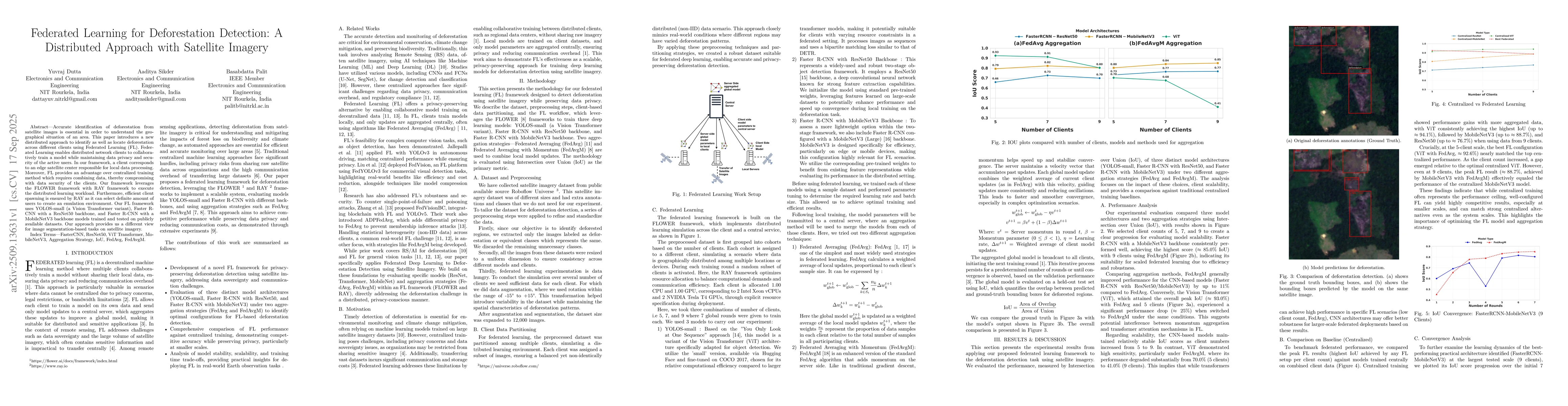
AI Key Findings

Generated Sep 20, 2025

Methodology

The research employs a federated learning framework using YOLOS-small, Faster R-CNN with ResNet50 and MobileNetV3 backbones, and leverages FLOWER and RAY frameworks for distributed training. The dataset is preprocessed, partitioned across clients, and models are trained with FedAvg and FedAvgM aggregation strategies.

Key Results

  • Faster R-CNN with MobileNetV3 backbone achieved the highest IoU score (≈85.0%) with 9 clients using FedAvgM.
  • ViT-based models (YOLOS-small) showed peak performance (≈93.0% IoU) with 5 clients under FedAvg but experienced a significant drop (≈25%) when using FedAvgM.
  • FedAvgM improved performance for CNN-based models by up to 11% compared to FedAvg, while demonstrating more stable convergence.

Significance

This research provides a privacy-preserving solution for deforestation detection using satellite imagery, enabling collaborative model training without sharing raw data. It addresses data privacy, scalability, and computational efficiency in environmental monitoring.

Technical Contribution

The paper introduces a federated learning framework for deforestation detection using satellite imagery, combining YOLOS-small, Faster R-CNN variants, and RAY/FLAVOR frameworks with FedAvg and FedAvgM aggregation strategies.

Novelty

This work applies federated learning to deforestation detection for the first time, specifically using satellite imagery with diverse model architectures and aggregation strategies, while addressing data privacy and scalability challenges.

Limitations

  • ViT models showed sensitivity to scaling and aggregation strategies, limiting their effectiveness in larger federated settings.
  • Training time increased with the number of clients, potentially affecting real-time deployment in large-scale scenarios.

Future Work

  • Optimizing transformer architectures for robust, large-scale federated learning.
  • Exploring hybrid aggregation strategies that combine FedAvg and FedAvgM for better performance.
  • Investigating additional lightweight models for edge computing in FL scenarios.

Paper Details

PDF Preview

Download PDF

Comments (0)

This website uses cookies to ensure you get the best experience. Learn more