ForestNet: Classifying Drivers of Deforestation in Indonesia using Deep Learning on Satellite Imagery
Publication
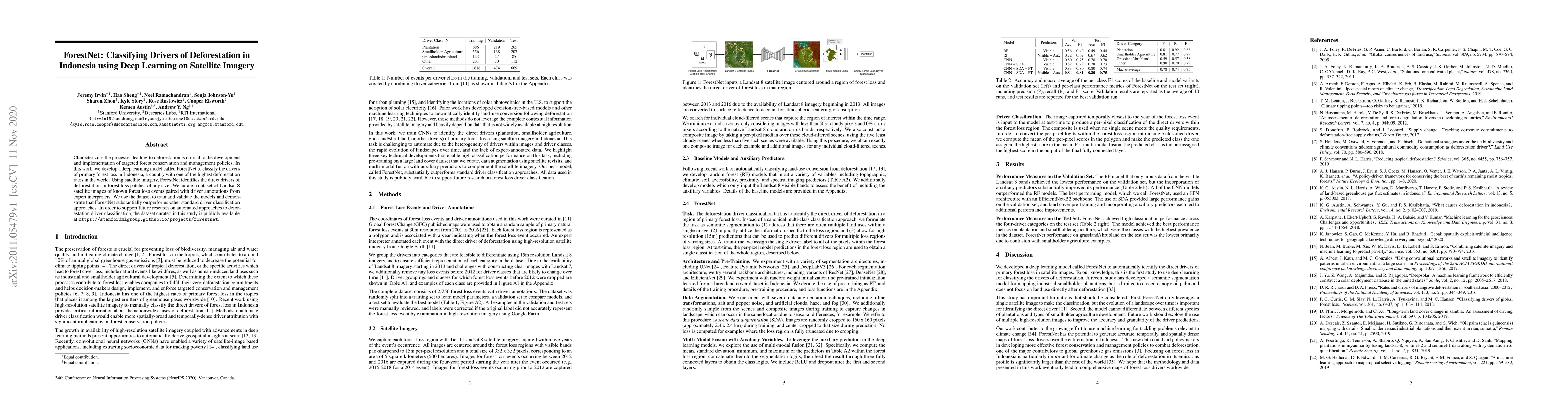
Metrics
AI Quick Summary
ForestNet, a deep learning model, classifies drivers of deforestation in Indonesia using satellite imagery, outperforming traditional methods. The study provides a curated dataset of Landsat 8 images and driver annotations, publicly available to support future research.
Paper Preview
Abstract
Characterizing the processes leading to deforestation is critical to the development and implementation of targeted forest conservation and management policies. In this work, we develop a deep learning model called ForestNet to classify the drivers of primary forest loss in Indonesia, a country with one of the highest deforestation rates in the world. Using satellite imagery, ForestNet identifies the direct drivers of deforestation in forest loss patches of any size. We curate a dataset of Landsat 8 satellite images of known forest loss events paired with driver annotations from expert interpreters. We use the dataset to train and validate the models and demonstrate that ForestNet substantially outperforms other standard driver classification approaches. In order to support future research on automated approaches to deforestation driver classification, the dataset curated in this study is publicly available at https://stanfordmlgroup.github.io/projects/forestnet .
AI Key Findings
Get AI-generated insights about this paper's methodology, results, significance, and more — seven facets brought into focus.
Impact
Paper Details
Authors
PDF Preview
Key Terms
Citation Network
Current paper (gray), citations (green), references (blue)
Display is limited for performance on very large graphs.
Discussion 0