Authors
Publication
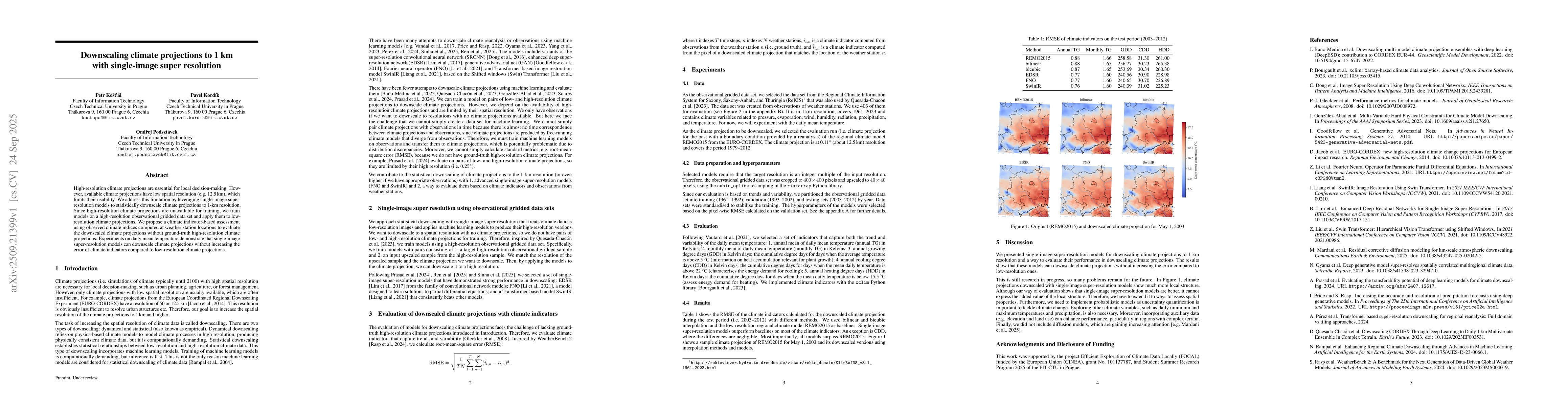
Metrics
Quick Actions
Quick Answers
What methodology did the authors use?
The study employs single-image super-resolution models to downscale low-resolution climate projections to 1 km resolution using high-resolution observational gridded data. Models like EDSR, FNO, and SwinIR are trained on observational data and applied to climate projections, evaluated using climate indicators computed from weather station observations. More in Methodology →
What are the key results?
Single-image super-resolution models outperform interpolation baselines in most climate indicators, maintaining or reducing error compared to low-resolution projections. — Downscaled climate projections using these models show improved local structure and better capture temperature trends and variability. More in Key Results →
Why is this work significant?
This research enables high-resolution climate projections critical for local decision-making, bridging the gap between coarse-resolution climate models and actionable climate data for regional planning and impact studies. More in Significance →
What are the main limitations?
Evaluation relies on climate indicators rather than direct comparison with high-resolution ground truth data. — The method assumes temporal alignment between climate projections and observations, which may not always hold. More in Limitations →
Paper Preview
Abstract
High-resolution climate projections are essential for local decision-making. However, available climate projections have low spatial resolution (e.g. 12.5 km), which limits their usability. We address this limitation by leveraging single-image super-resolution models to statistically downscale climate projections to 1-km resolution. Since high-resolution climate projections are unavailable for training, we train models on a high-resolution observational gridded data set and apply them to low-resolution climate projections. We propose a climate indicator-based assessment using observed climate indices computed at weather station locations to evaluate the downscaled climate projections without ground-truth high-resolution climate projections. Experiments on daily mean temperature demonstrate that single-image super-resolution models can downscale climate projections without increasing the error of climate indicators compared to low-resolution climate projections.
AI Key Findings
Generated Oct 01, 2025
Methodology — What approach did the authors take?
The study employs single-image super-resolution models to downscale low-resolution climate projections to 1 km resolution using high-resolution observational gridded data. Models like EDSR, FNO, and SwinIR are trained on observational data and applied to climate projections, evaluated using climate indicators computed from weather station observations.
Key Results — What are the main findings?
- Single-image super-resolution models outperform interpolation baselines in most climate indicators, maintaining or reducing error compared to low-resolution projections.
- Downscaled climate projections using these models show improved local structure and better capture temperature trends and variability.
- All models surpass the performance of the low-resolution regional climate model REMO2015 across multiple metrics.
Significance — Why does this research matter?
This research enables high-resolution climate projections critical for local decision-making, bridging the gap between coarse-resolution climate models and actionable climate data for regional planning and impact studies.
Technical Contribution — What is the technical contribution?
Development of a framework to transfer single-image super-resolution models trained on observational data to downscale climate projections, enabling high-resolution climate analysis without requiring high-resolution climate projections for training.
Novelty — What is new about this work?
The work introduces a novel approach to climate downscaling by leveraging advanced image super-resolution techniques and climate indicator-based evaluation, addressing the lack of high-resolution climate projections for training.
Limitations — What are the limitations of this study?
- Evaluation relies on climate indicators rather than direct comparison with high-resolution ground truth data.
- The method assumes temporal alignment between climate projections and observations, which may not always hold.
Future Work — What did the authors propose for future work?
- Incorporate probabilistic models for uncertainty quantification in climate projections.
- Extend to other climate variables like precipitation and temperature extremes.
- Integrate auxiliary data (e.g., elevation, land use) to improve performance in complex terrains.
- Explore diffusion models and other advanced architectures for further enhancement.
How to Cite This Paper
@article{podsztavek2025downscaling,
  title         = {Downscaling climate projections to 1 km with single-image super
  resolution},
  author        = {Podsztavek, Ondřej and Kordík, Pavel and Košťál, Petr},
  year          = {2025},
  eprint        = {2509.21399},
  archivePrefix = {arXiv},
  primaryClass  = {cs.CV},
}Podsztavek, O., Kordík, P., & Košťál, P. (2025). Downscaling climate projections to 1 km with single-image super
resolution. arXiv. https://arxiv.org/abs/2509.21399Podsztavek, Ondřej, et al. "Downscaling climate projections to 1 km with single-image super
resolution." arXiv, 2025, arxiv.org/abs/2509.21399.PDF Preview
Similar Papers
Found 4 papersDeepSD: Generating High Resolution Climate Change Projections through Single Image Super-Resolution
High-Resolution Climate Projections Using Diffusion-Based Downscaling of a Lightweight Climate Emulator
Haiwen Guan, Moein Darman, Dibyajyoti Chakraborty et al.
CASCADE: Cross-scale Advective Super-resolution with Climate Assimilation and Downscaling Evolution
Alexander Kovalenko
Comments (0)