Quick Summary:

This paper proposes a Quadruple Semantic Align Net (SAN-QUAD) to enhance ground-to-aerial image matching for detecting visual misinformation, leveraging semantic segmentation for both ground and satellite images. Experimental results show a 9.8% improvement over previous methods in matching images across different fields of view.

Summary

The recent advancements in generative AI techniques, which have significantly increased the online dissemination of altered images and videos, have raised serious concerns about the credibility of digital media available on the Internet and distributed through information channels and social networks. This issue particularly affects domains that rely heavily on trustworthy data, such as journalism, forensic analysis, and Earth observation. To address these concerns, the ability to geolocate a non-geo-tagged ground-view image without external information, such as GPS coordinates, has become increasingly critical. This study tackles the challenge of linking a ground-view image, potentially exhibiting varying fields of view (FoV), to its corresponding satellite image without the aid of GPS data. To achieve this, we propose a novel four-stream Siamese-like architecture, the Quadruple Semantic Align Net (SAN-QUAD), which extends previous state-of-the-art (SOTA) approaches by leveraging semantic segmentation applied to both ground and satellite imagery. Experimental results on a subset of the CVUSA dataset demonstrate significant improvements of up to 9.8% over prior methods across various FoV settings.

AI Key Findings

Generated Jun 11, 2025

Methodology

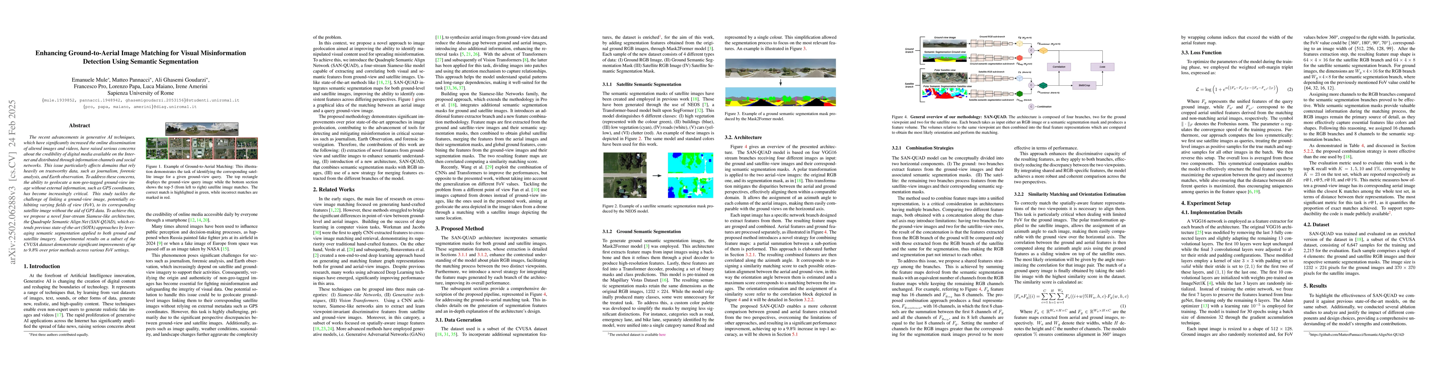
The paper proposes a novel four-stream Siamese-like architecture, Quadruple Semantic Align Net (SAN-QUAD), which uses semantic segmentation applied to both ground and satellite imagery for enhancing ground-to-aerial image matching. The architecture consists of four branches, two for ground-view images and their semantic segmentation masks, and two for satellite-view images and their semantic segmentation masks. A polar transformation is applied to aerial-view images to mitigate disparities between aerial and ground perspectives.

Key Results

  • SAN-QUAD achieved up to 9.8% improvement in top-1 accuracy compared to prior methods across various fields of view (FoV) settings on a subset of the CVUSA dataset.
  • The model outperformed previous state-of-the-art methods in terms of recall-at-1 (r@1) metric, reaching 82.35% on a 360° FoV test, which is 9.8% higher than the previous best method (SAN) and 5.3% higher than Shi et al. [23].
  • Ablation studies demonstrated that including additional semantic features, using the partial sum operator for combining feature branches, and integrating features from both viewpoints improved performance.

Significance

This research is significant as it addresses the critical issue of geolocating ground-view images without relying on GPS data, which is crucial for domains like journalism, forensic analysis, and Earth observation. The proposed method can serve as a supportive tool in forensic analysis, particularly in reconstructing the location of non-geo-tagged images or verifying the authenticity of reported news.

Technical Contribution

The main technical contribution is the development of the SAN-QUAD architecture, which leverages semantic segmentation for both ground and satellite imagery to improve ground-to-aerial image matching, resulting in significant performance improvements.

Novelty

The novelty of this work lies in the four-stream Siamese-like architecture (SAN-QUAD) that incorporates semantic segmentation for both ground and satellite imagery, along with a polar transformation to align aerial and ground perspectives, leading to improved matching accuracy compared to existing methods.

Limitations

  • The study was limited to a subset of the CVUSA dataset, and future work should evaluate the method on additional datasets.
  • The current approach does not consider other potential features for ground and satellite views, which could further enhance performance.

Future Work

  • Integrate additional features for ground and satellite views, considering combining them before passing through feature extractors.
  • Extend the work to other datasets for training and evaluation to ensure broader applicability and generalization.

Paper Details

PDF Preview

Download PDF

Key Terms

No key terms available for this paper.

Citation Network

Current paper (gray), citations (green), references (blue)

Current Paper
Citations
References
Click to view

Similar Papers

Found 4 papers

No citations found for this paper.

Comments (0)

This website uses cookies to ensure you get the best experience. Learn more