ArxivLens

Publication

Published: May 08, 2025
Updated: Jun 17, 2025
Categories: cs.CV, cs.AI

Metrics

Citations: 1
Source: ArXiv

AI Quick Summary

A new AI model called YOLO-DCAP improves object localization in satellite images by combining dilated convolutions with attention-aided spatial pooling, achieving 20.95% average improvement over existing models.

Quick Answers

What is "Enhancing Satellite Object Localization with Dilated Convolutions and Attention-aided Spatial Pooling" about?

A new AI model called YOLO-DCAP improves object localization in satellite images by combining dilated convolutions with attention-aided spatial pooling, achieving 20.95% average improvement over existing models.

What methodology did the authors use?

The research introduces YOLO-DCAP, an enhanced YOLOv5 model for satellite object localization. It incorporates a Multi-scale Dilated Residual Convolution (MDRC) block and an Attention-aided Spatial Pooling (AaSP) module to address challenges in satellite imagery analysis, such as variability in object scale and appearance, low resolution, and noise interference. More in Methodology →

What are the key results?

YOLO-DCAP significantly outperforms the YOLO base model and state-of-the-art approaches. — An average improvement of 20.95% in mAP50 and 32.23% in IoU over the base model. More in Key Results →

Why is this work significant?

This research is important as it presents a novel method (YOLO-DCAP) that significantly improves object localization in complex satellite imagery, which is crucial for various applications including atmospheric and remote sensing studies. More in Significance →

What are the main limitations?

The paper does not discuss limitations explicitly, but potential limitations could include the reliance on specific datasets for validation and the computational resources required for training the dilated convolution models. — Generalizability to other types of satellite imagery beyond the tested datasets (Gravity Waves, Bores, and Ocean Eddies) is not explicitly addressed. More in Limitations →

Paper Preview

Abstract

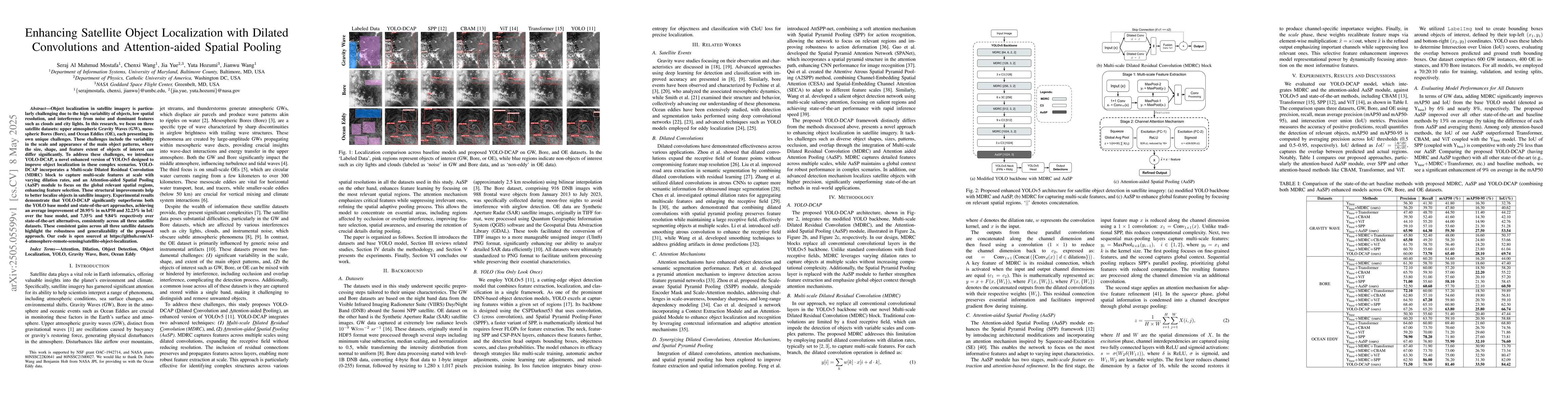
Object localization in satellite imagery is particularly challenging due to the high variability of objects, low spatial resolution, and interference from noise and dominant features such as clouds and city lights. In this research, we focus on three satellite datasets: upper atmospheric Gravity Waves (GW), mesospheric Bores (Bore), and Ocean Eddies (OE), each presenting its own unique challenges. These challenges include the variability in the scale and appearance of the main object patterns, where the size, shape, and feature extent of objects of interest can differ significantly. To address these challenges, we introduce YOLO-DCAP, a novel enhanced version of YOLOv5 designed to improve object localization in these complex scenarios. YOLO-DCAP incorporates a Multi-scale Dilated Residual Convolution (MDRC) block to capture multi-scale features at scale with varying dilation rates, and an Attention-aided Spatial Pooling (AaSP) module to focus on the global relevant spatial regions, enhancing feature selection. These structural improvements help to better localize objects in satellite imagery. Experimental results demonstrate that YOLO-DCAP significantly outperforms both the YOLO base model and state-of-the-art approaches, achieving an average improvement of 20.95% in mAP50 and 32.23% in IoU over the base model, and 7.35% and 9.84% respectively over state-of-the-art alternatives, consistently across all three satellite datasets. These consistent gains across all three satellite datasets highlight the robustness and generalizability of the proposed approach. Our code is open sourced at https://github.com/AI-4-atmosphere-remote-sensing/satellite-object-localization.

Key Findings, in focus

Seven facets of this paper, analysed and brought into focus by AI.

AI-generated · verify against source Generated Jun 08, 2025
In focus · one-line synthesis

This research is important as it presents a novel method (YOLO-DCAP) that significantly improves object localization in complex satellite imagery, which is crucial for various applications including atmospheric and remote sensing studies.

01
MethodologyHow they did it

The research introduces YOLO-DCAP, an enhanced YOLOv5 model for satellite object localization. It incorporates a Multi-scale Dilated Residual Convolution (MDRC) block and an Attention-aided Spatial Pooling (AaSP) module to address challenges in satellite imagery analysis, such as variability in object scale and appearance, low resolution, and noise interference.

02
ResultsWhat they found
  • YOLO-DCAP significantly outperforms the YOLO base model and state-of-the-art approaches.
  • An average improvement of 20.95% in mAP50 and 32.23% in IoU over the base model.
  • Improvements of 7.35% and 9.84% respectively over state-of-the-art alternatives.
  • Consistent gains across three satellite datasets (Gravity Waves, Bores, and Ocean Eddies) indicating robustness and generalizability.
03
SignificanceWhy it matters

This research is important as it presents a novel method (YOLO-DCAP) that significantly improves object localization in complex satellite imagery, which is crucial for various applications including atmospheric and remote sensing studies.

04
Technical ContributionsWhat's new technically

The technical contribution lies in the development of YOLO-DCAP, which integrates dilated convolutions with attention-aided spatial pooling to enhance feature extraction and localization accuracy in satellite imagery.

05
NoveltyWhat sets it apart

The novelty of this work stems from the combination of dilated convolutions with attention-aided pooling in the YOLO framework specifically tailored for satellite object localization, addressing unique challenges posed by such imagery.

06
LimitationsWhat to be cautious about
  • The paper does not discuss limitations explicitly, but potential limitations could include the reliance on specific datasets for validation and the computational resources required for training the dilated convolution models.
  • Generalizability to other types of satellite imagery beyond the tested datasets (Gravity Waves, Bores, and Ocean Eddies) is not explicitly addressed.
07
Future WorkWhere it goes next
  • Exploring the application of YOLO-DCAP to other satellite imagery types and scenarios.
  • Investigating methods to further reduce computational demands for real-time or resource-constrained applications.

Impact

1
Citations
43
References

Paper Details

Paper ID: 2505.05599
Comments: This paper has been accepted to International conference on Advanced Machine Learning and Data Science (AMLDS) 2025
Categories:
cs.CV cs.AI

How to Cite This Paper

Reference manager: RIS EndNote

Citation Network

Current paper (gray), citations (green), references (blue)

Display is limited for performance on very large graphs.

Current Paper
Citations
References
Click to view


Discussion 0

This website uses cookies to ensure you get the best experience. Learn more