Estimating Traffic Disruption Patterns with Volunteered Geographic Information
Publication
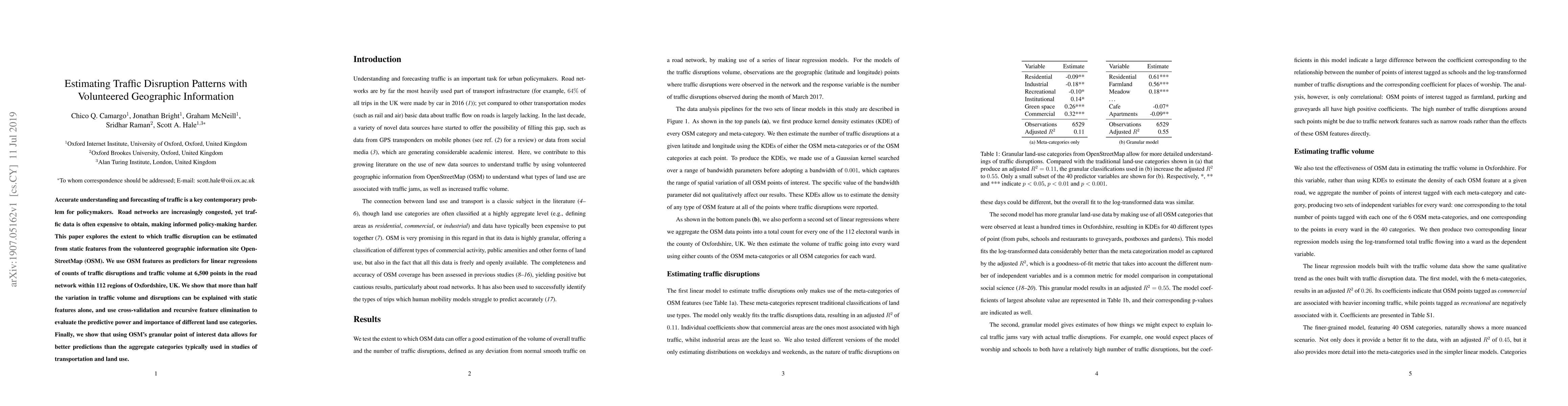
Metrics
AI Quick Summary
This paper investigates using OpenStreetMap (OSM) data to estimate traffic disruption patterns, demonstrating that static OSM features can explain over half the variation in traffic volume and disruptions. It finds that granular point of interest data from OSM provides better predictive power than aggregate land use categories.
Paper Preview
Abstract
Accurate understanding and forecasting of traffic is a key contemporary problem for policymakers. Road networks are increasingly congested, yet traffic data is often expensive to obtain, making informed policy-making harder. This paper explores the extent to which traffic disruption can be estimated from static features from the volunteered geographic information site OpenStreetMap (OSM). We use OSM features as predictors for linear regressions of counts of traffic disruptions and traffic volume at 6,500 points in the road network within 112 regions of Oxfordshire, UK. We show that more than half the variation in traffic volume and disruptions can be explained with static features alone, and use cross-validation and recursive feature elimination to evaluate the predictive power and importance of different land use categories. Finally, we show that using OSM's granular point of interest data allows for better predictions than the aggregate categories typically used in studies of transportation and land use.
AI Key Findings
Get AI-generated insights about this paper's methodology, results, significance, and more — seven facets brought into focus.
Impact
Paper Details
PDF Preview
Key Terms
Citation Network
Current paper (gray), citations (green), references (blue)
Display is limited for performance on very large graphs.
Discussion 0