ArxivLens

Quick Summary:

This paper explores how volunteered geographic information (VGI) reshapes computational geography, emphasizing data-intensive computing and simulations to reveal geographic mechanisms. It uses OpenStreetMap and GPS data to study the scaling of geographic space and human mobility, highlighting the distinction between geoinformatics and computational geography.

Journal Reference: Sui D., Elwood S. and Goodchild M. (editors), Crowdsourcing Geographic Knowledge: Volunteered Geographic Information (VGI) in Theory and Practice, Springer: Berlin, 125-138, 2013
DOI: 10.1007/978-94-007-4587-2_8
arXiv Id: 1212.0941
Comments: 13 pages, 5 figures
Date Published: 2020-11-09
Date Updated: 2020-11-09

Key Terms (TF-IDF):

web (0.290)
web (0.266)
computational (0.247)
computational (0.240)
scaling (0.215)
scaling (0.214)
heterogeneity (0.185)
distinguished (0.182)
intensive (0.180)
traces (0.179)
uncover (0.179)
perspectives (0.179)
discusses (0.178)
transformed (0.178)
dramatic (0.176)
heterogeneity (0.176)
intensive (0.176)
provides new (0.176)
perspectives (0.170)
transformed (0.169)
License: http://creativecommons.org/licenses/by/3.0/

Summary:

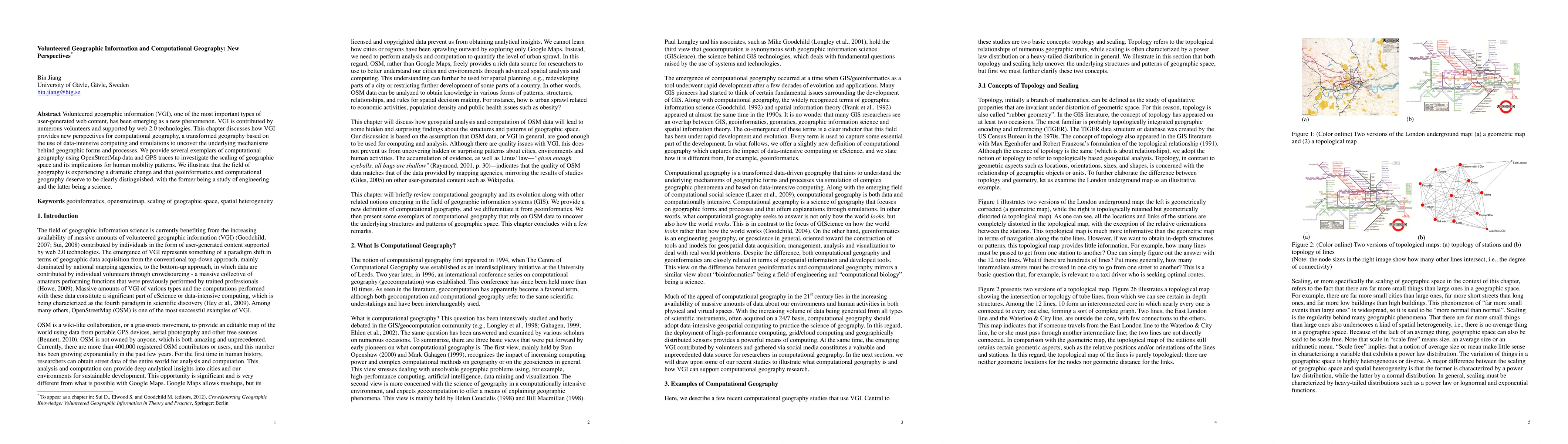
Volunteered geographic information (VGI), one of the most important types of user-generated web content, has been emerging as a new phenomenon. VGI is contributed by numerous volunteers and supported by web 2.0 technologies. This chapter discusses how VGI provides new perspectives for computational geography, a transformed geography based on the use of data-intensive computing and simulations to uncover the underlying mechanisms behind geographic forms and processes. We provide several exemplars of computational geography using OpenStreetMap data and GPS traces to investigate the scaling of geographic space and its implications for human mobility patterns. We illustrate that the field of geography is experiencing a dramatic change and that geoinformatics and computational geography deserve to be clearly distinguished, with the former being a study of engineering and the latter being a science. Keywords geoinformatics, openstreetmap, scaling of geographic space, spatial heterogeneity

Citation & Reference Network Visualization

This graph shows how this paper is connected to other research. The current paper is shown in dark gray, papers that cite it are in green, and papers it references are in blue. You can:

Current Paper
Papers citing this work (Citations)
Papers cited by this work (References)

• Hover over any node to see the paper title

• Click a node to view that paper's details

• Drag nodes to rearrange the graph

• Use the zoom controls (bottom right) to zoom in/out

Citations and References

Title Authors Year Actions
Comparative Analysis of Axial Map Drawing Methods: Elazığ Application
Emrah Şıkoğlu
2021
View Paper
Data validation and quality assessment of voluntary geographic information road network of Castellon for emergency route planning
E. Shrestha
2019
View Paper
Automated Matching of Multi-Scale Building Data Based on Relaxation Labelling and Pattern Combinations
Yunfei Zhang, Jincai Huang, M. Deng, Chi Chen, Fangbin Zhou, Shuchun Xie, Xiaoliang Fang
2019
View Paper
A geospatial approach of downscaling urban energy consumption density in mega-city Dhaka, Bangladesh
S. K. Sikder, M. Nagarajan, S. Kar, T. Koetter
2018
View Paper
Exploration of the Meaning of A Place by Volunteered Geographic Information
B. Tsai, Ming-Kuang Chung, Yu-Ling Hsu
2018
View Paper
Mapping Rural Road Networks from Global Positioning System (GPS) Trajectories of Motorcycle Taxis in Sigomre Area, Siaya County, Kenya
Francis Oloo
2018
View Paper
Towards a Cyberspatial Infrastructure for GeoDeliberative Social Participation Systems
Guoray Cai
2018
View Paper
Diversity in volunteered geographic information: comparing OpenStreetMap and Wikimapia in Jerusalem
C. Bittner
2017
View Paper
Geospatial big data and cartography: research challenges and opportunities for making maps that matter
A. Robinson, Urška Demšar, A. Moore, Aileen R. Buckley, B. Jiang, K. Field, M. J. Kraak, S. Camboim, C. R. Sluter
2017
View Paper
Leveraging VGI Integrated with 3D Spatial Technology to Support Urban Intensification in Melbourne, Australia
S. Sabri, A. Rajabifard, S. Ho, Sam Amirebrahimi, I. Bishop
2016
View Paper
Diversity in volunteered geographic information: comparing OpenStreetMap and Wikimapia in Jerusalem
C. Bittner
2016
View Paper
Pattern-mining approach for conflating crowdsourcing road networks with POIs
Bisheng Yang, Yunfei Zhang
2015
View Paper
Finding topological center of a geographic space via road network
Liang Gao, Yanan Miao, Yuhao Qin, Xiaomei Zhao, Ziyou Gao
2015
View Paper
The Road to Direction - Assessing the Impact of Road Asymmetry on Street Network Small-Worldness
M. Sainte-Marie
2014
View Paper
Tourists vs. Locals: Mapping Urban Traces from Social Media
2019
View Paper
Quality Evaluation of Volunteered Geographic Information
Hongyu Zhang, Jacek Malczewski
2019
View Paper
Quality Assessment of the Canadian OpenStreetMap Road Networks
Hongyu Zhang
2017
View Paper
Quality Evaluation of Volunteered Geographic Information: The Case of OpenStreetMap
Hongyu Zhang, Jacek Malczewski
2017
View Paper
CHAPTER 13 Head / tail Breaks for Visualization of City Structure and Dynamics
B. Jiang
2016
View Paper
Building a Multimodal Urban Network Model Using OpenStreetMap Data for the Analysis of Sustainable Accessibility
J. Gil
2015
View Paper
Comparative Analysis of Urban Morphology: Evaluating Space Syntax and Traditional Morphological Methods
Xiaowei Sun
2013
View Paper
Discriminative Clustering Algorithms For Document Understanding, Tag Recommendation, And Web Surfer Behavior Prediction
Malik Tahir Hassan
2013
View Paper

Comments (0)

This website uses cookies to ensure you get the best experience. Learn more