This paper outlines the theoretical and practical foundations for building an ETL infrastructure to integrate remote sensing data from various sources, emphasizing modular analysis and a Python library for workflow management. The proposed system aims to facilitate the downloading, transformation, and integration of data from different instruments into diverse data warehouses.
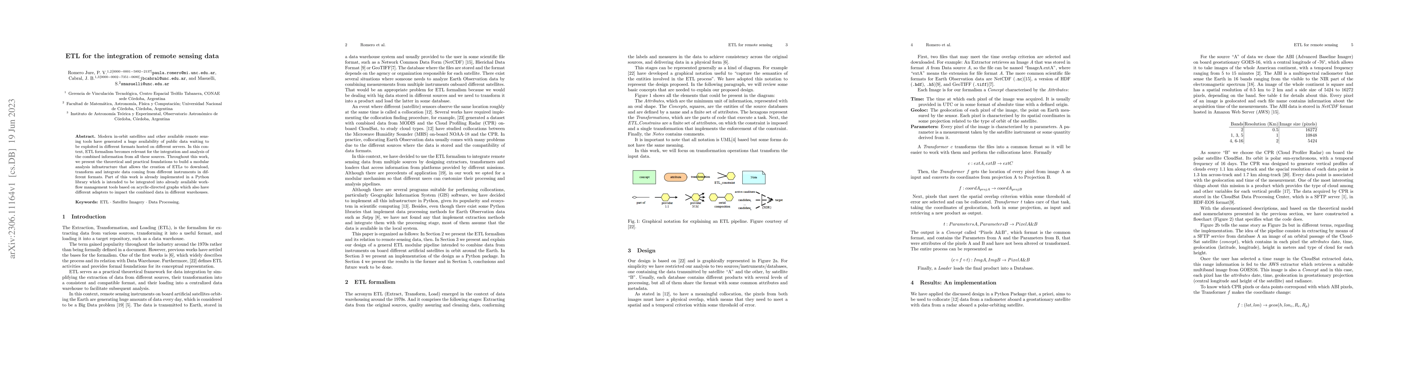
Modern in-orbit satellites and other available remote sensing tools have generated a huge availability of public data waiting to be exploited in different formats hosted on different servers. In this context, ETL formalism becomes relevant for the integration and analysis of the combined information from all these sources. Throughout this work, we present the theoretical and practical foundations to build a modular analysis infrastructure that allows the creation of ETLs to download, transform and integrate data coming from different instruments in different formats. Part of this work is already implemented in a Python library which is intended to be integrated into already available workflow management tools based on acyclic-directed graphs which also have different adapters to impact the combined data in different warehouses.
This graph shows how this paper is connected to other research. The current paper is shown in dark gray, papers that cite it are in green, and papers it references are in blue. You can:
• Hover over any node to see the paper title
• Click a node to view that paper's details
• Drag nodes to rearrange the graph
• Use the zoom controls (bottom right) to zoom in/out
No citations found for this paper.
Published: 2018-04-25
Katja Hose, Torben Bach Pedersen, Rudra Pratap Deb Nath, Oscar Romero
Published: 2024-03-19
Stella X. Yu, Xudong Wang, Charles Hill, Chun-Hsiao Yeh, Zackery Steck, Scott Kangas, Aaron Reite
Published: 2023-12-27
Comments (0)