Quick Summary:

This paper reviews the interdisciplinary integration of remote sensing with examples from ecology, mathematical morphology, machine learning, and electronics, highlighting its reliance on various disciplines and technologies for development and application.

Authors:

Summary

As a high-level discipline, the development of remote sensing depends on the contribution of many other basic and applied disciplines and technologies. For 
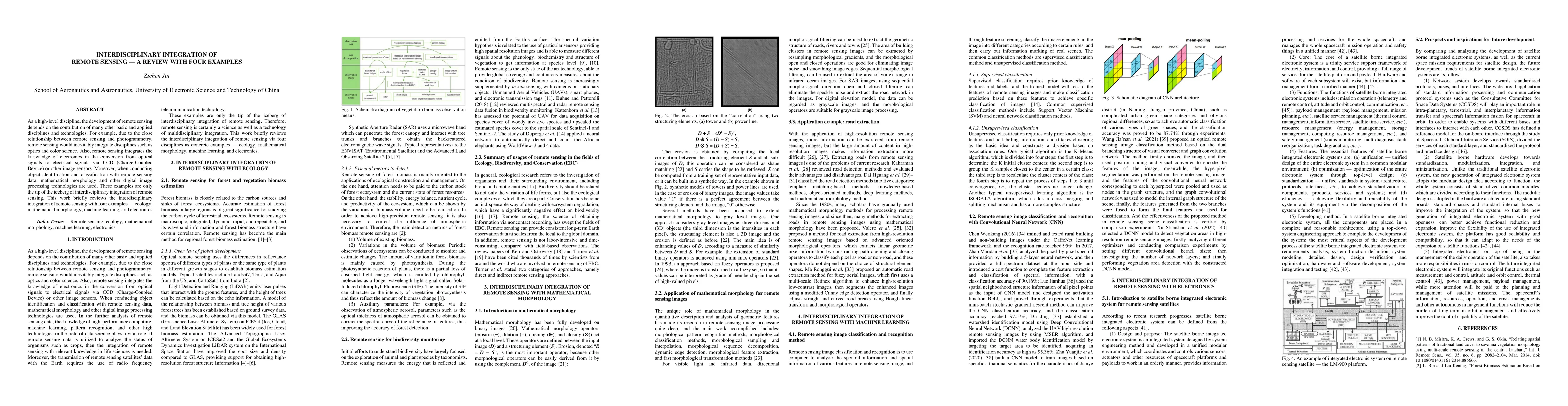
example, due to the close relationship between remote sensing and photogrammetry, remote sensing would inevitably integrate disciplines such as optics and color science. Also, remote sensing integrates the knowledge of electronics in the conversion from optical signals to electrical signals via CCD (Charge-Coupled Device) or other image sensors. Moreover, when conducting object identification and classification with remote sensing data, mathematical morphology and other digital image processing technologies are used. These examples are only the tip of the iceberg of interdisciplinary integration of remote sensing. This work briefly reviews the interdisciplinary integration of remote sensing with four examples - ecology, mathematical morphology, machine learning, and electronics.

AI Key Findings

Generated Jun 09, 2025

Methodology

The paper provides a review of interdisciplinary integration of remote sensing, focusing on four examples: ecology, mathematical morphology, machine learning, and electronics.

Key Results

  • Remote sensing integrates various disciplines such as optics, color science, electronics, and digital image processing.
  • In ecology, remote sensing is used for vegetation biomass observation, focusing on volume, variations, and auxiliary parameters.
  • Mathematical morphology is applied for geometric feature description and analysis in remote sensing images, including pattern recognition, classification, and feature extraction.
  • Machine learning methods, especially Convolutional Neural Networks (CNN), have been successfully applied for remote sensing image classification and recognition with high accuracy.
  • Satellite-borne integrated electronic systems are crucial for coordinating and controlling various sensors, actuators, and resources on spacecraft platforms and payloads.

Significance

This review highlights the importance of interdisciplinary integration in remote sensing, showcasing its applications in ecology, image processing, and machine learning, which can significantly improve data analysis and decision-making in various fields.

Technical Contribution

The paper presents a comprehensive overview of interdisciplinary integration in remote sensing, emphasizing the role of mathematical morphology, machine learning, and electronics.

Novelty

This work stands out by synthesizing various interdisciplinary aspects of remote sensing, providing a valuable resource for researchers and practitioners interested in understanding and advancing remote sensing technologies.

Limitations

  • The review does not provide in-depth analysis of each integrated discipline, focusing mainly on brief descriptions and examples.
  • The paper does not discuss potential challenges or barriers to the integration of remote sensing with other disciplines.

Future Work

  • Further research could explore innovative ways to integrate remote sensing with additional disciplines.
  • Investigating the scalability and adaptability of machine learning methods for diverse remote sensing applications.

Paper Details

PDF Preview

Download PDF

Key Terms

No key terms available for this paper.

Citation Network

Current paper (gray), citations (green), references (blue)

Current Paper
Citations
References
Click to view

No citations found for this paper.

Comments (0)

This website uses cookies to ensure you get the best experience. Learn more