FLiCR: A Fast and Lightweight LiDAR Point Cloud Compression Based on Lossy RI
Publication
Metrics
AI Quick Summary
FLiCR is a fast and lightweight LiDAR point cloud compression method based on lossy range images and dictionary coding, designed for edge-assisted real-time perceptions. It introduces a new quality metric to better reflect the entropy and point-wise qualities of compressed data, outperforming existing compression methods in real-time 3D object detection and LiDAR SLAM.
Paper Preview
Abstract
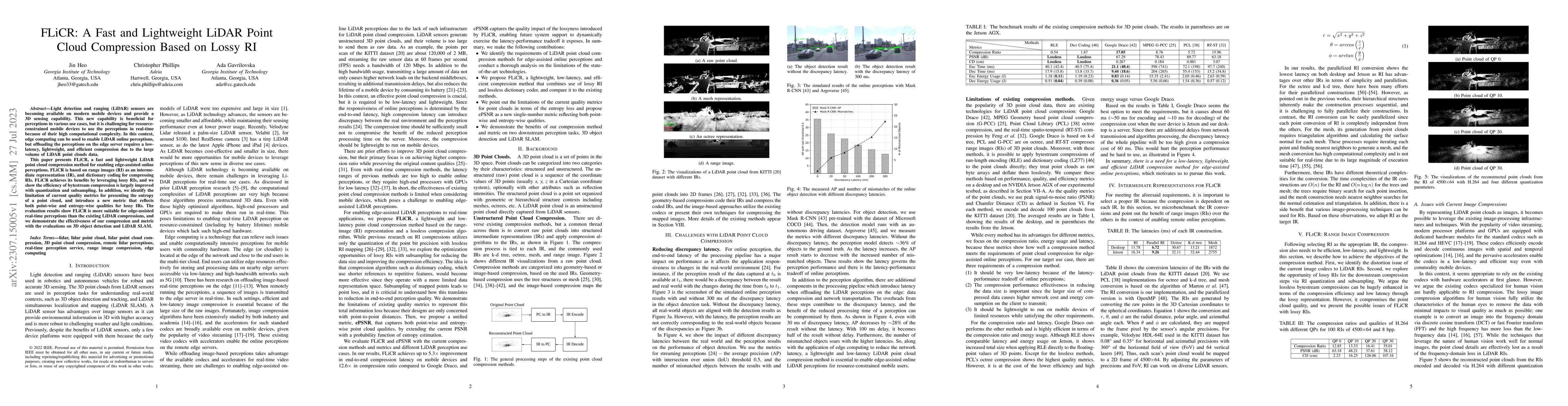
Light detection and ranging (LiDAR) sensors are becoming available on modern mobile devices and provide a 3D sensing capability. This new capability is beneficial for perceptions in various use cases, but it is challenging for resource-constrained mobile devices to use the perceptions in real-time because of their high computational complexity. In this context, edge computing can be used to enable LiDAR online perceptions, but offloading the perceptions on the edge server requires a low-latency, lightweight, and efficient compression due to the large volume of LiDAR point clouds data. This paper presents FLiCR, a fast and lightweight LiDAR point cloud compression method for enabling edge-assisted online perceptions. FLiCR is based on range images (RI) as an intermediate representation (IR), and dictionary coding for compressing RIs. FLiCR achieves its benefits by leveraging lossy RIs, and we show the efficiency of bytestream compression is largely improved with quantization and subsampling. In addition, we identify the limitation of current quality metrics for presenting the entropy of a point cloud, and introduce a new metric that reflects both point-wise and entropy-wise qualities for lossy IRs. The evaluation results show FLiCR is more suitable for edge-assisted real-time perceptions than the existing LiDAR compressions, and we demonstrate the effectiveness of our compression and metric with the evaluations on 3D object detection and LiDAR SLAM.
AI Key Findings
Get AI-generated insights about this paper's methodology, results, significance, and more — seven facets brought into focus.
Impact
Paper Details
Authors
PDF Preview
Key Terms
Citation Network
Current paper (gray), citations (green), references (blue)
Display is limited for performance on very large graphs.
Discussion 0