Foundation Models for Geospatial Reasoning: Assessing Capabilities of Large Language Models in Understanding Geometries and Topological Spatial Relations

Source: ArXiv

AI Quick Summary

Large language models like GPT-4 achieve high accuracy in understanding geospatial relations and geometries, with some models performing better than others when given additional context or prompts.

Share: Share on X LinkedIn

Summary

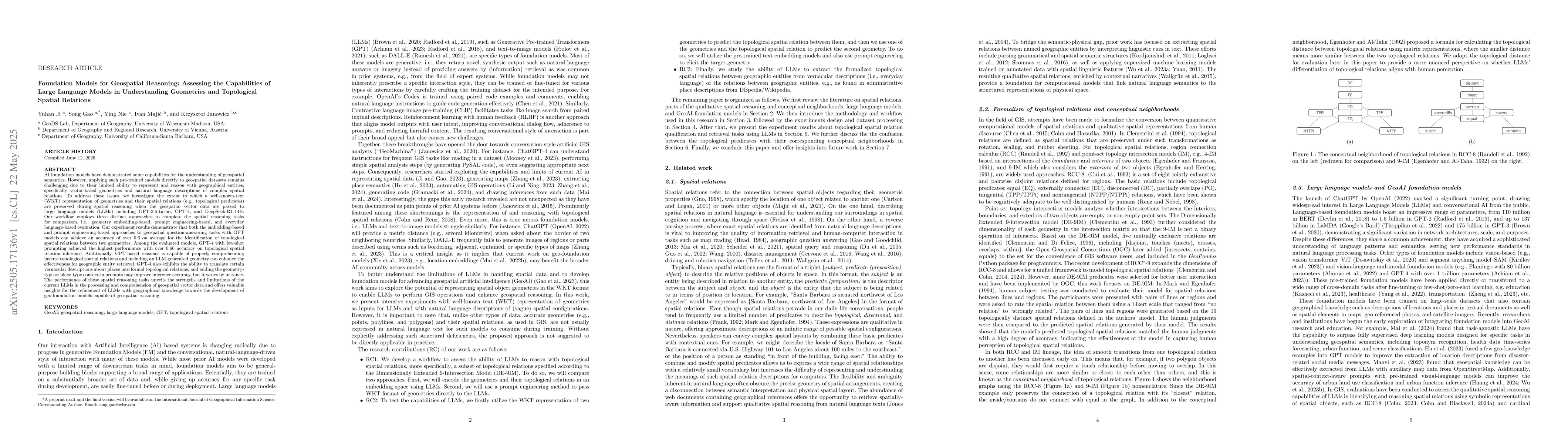
Applying AI foundation models directly to geospatial datasets remains challenging due to their limited ability to represent and reason with geographical entities, specifically vector-based geometries and natural language descriptions of complex spatial relations. To address these issues, we investigate the extent to which a well-known-text (WKT) representation of geometries and their spatial relations (e.g., topological predicates) are preserved during spatial reasoning when the geospatial vector data are passed to large language models (LLMs) including GPT-3.5-turbo, GPT-4, and DeepSeek-R1-14B. Our workflow employs three distinct approaches to complete the spatial reasoning tasks for comparison, i.e., geometry embedding-based, prompt engineering-based, and everyday language-based evaluation. Our experiment results demonstrate that both the embedding-based and prompt engineering-based approaches to geospatial question-answering tasks with GPT models can achieve an accuracy of over 0.6 on average for the identification of topological spatial relations between two geometries. Among the evaluated models, GPT-4 with few-shot prompting achieved the highest performance with over 0.66 accuracy on topological spatial relation inference. Additionally, GPT-based reasoner is capable of properly comprehending inverse topological spatial relations and including an LLM-generated geometry can enhance the effectiveness for geographic entity retrieval. GPT-4 also exhibits the ability to translate certain vernacular descriptions about places into formal topological relations, and adding the geometry-type or place-type context in prompts may improve inference accuracy, but it varies by instance. The performance of these spatial reasoning tasks offers valuable insights for the refinement of LLMs with geographical knowledge towards the development of geo-foundation models capable of geospatial reasoning.

AI Key Findings

Generated Jun 07, 2025

Methodology

The research investigates the capabilities of large language models (LLMs) including GPT-3.5-turbo, GPT-4, and DeepSeek-R1-14B in understanding geometries and topological spatial relations by employing three approaches: geometry embedding-based, prompt engineering-based, and everyday language-based evaluation.

Key Results

  • Both embedding-based and prompt engineering-based approaches achieved an average accuracy of over 0.6 for identifying topological spatial relations between geometries.
  • GPT-4 with few-shot prompting demonstrated the highest performance, surpassing 0.66 accuracy in topological spatial relation inference.
  • GPT-based reasoner effectively comprehended inverse topological spatial relations.
  • LLM-generated geometry inclusion enhanced geographic entity retrieval effectiveness.
  • GPT-4 showed ability to translate vernacular descriptions into formal topological relations.

Significance

This research offers insights into refining LLMs with geographical knowledge, paving the way for the development of geo-foundation models capable of geospatial reasoning.

Technical Contribution

The paper presents a comprehensive evaluation of LLMs in understanding geometries and topological spatial relations using embedding, prompt engineering, and everyday language approaches.

Novelty

The work distinguishes itself by systematically assessing multiple LLMs' performance on geospatial reasoning tasks, identifying GPT-4's superiority, and highlighting the potential of LLMs in geo-foundation model development.

Limitations

  • The study did not extensively explore the generalization of these findings across diverse geospatial datasets.
  • Performance variations with context addition in prompts suggest potential overfitting to specific instances.

Future Work

  • Investigate the generalizability of these models across varied geospatial datasets.
  • Explore techniques to mitigate overfitting when incorporating context in prompts.

Paper Details

PDF Preview

Download PDF

Citation Network

Current paper (gray), citations (green), references (blue)

Display is limited for performance on very large graphs.

Current Paper
Citations
References
Click to view

No citations found for this paper.

Comments (0)

This website uses cookies to ensure you get the best experience. Learn more