Publication
Metrics
Paper Preview
Abstract
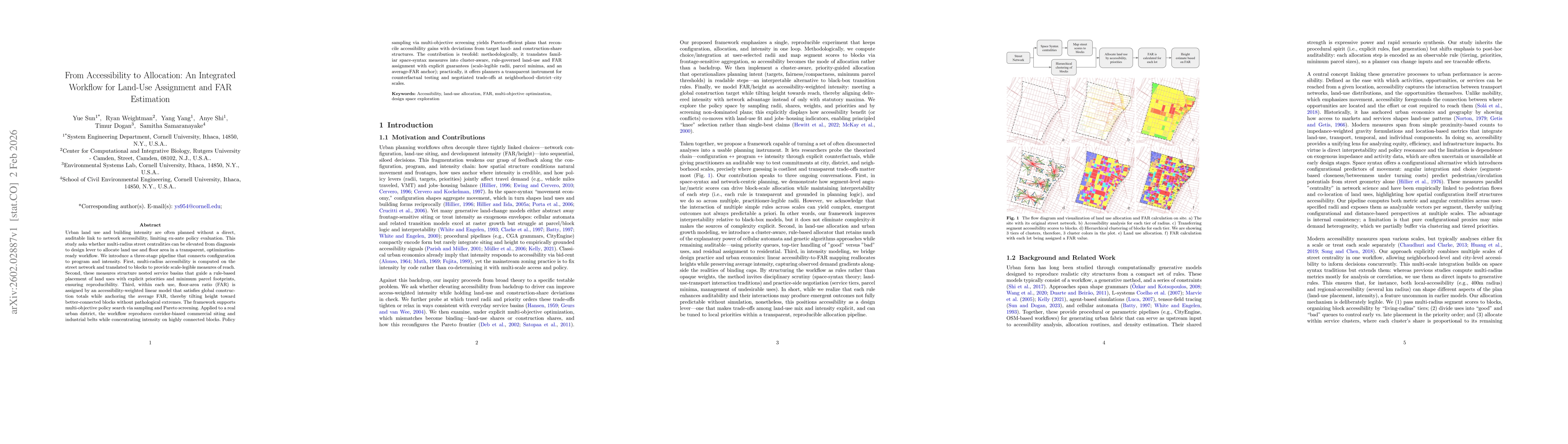
Urban land use and building intensity are often planned without a direct, auditable link to network accessibility, limiting ex-ante policy evaluation. This study asks whether multi-radius street centralities can be elevated from diagnosis to design lever to allocate land use and floor area in a transparent, optimization-ready workflow. We introduce a three-stage pipeline that connects configuration to program and intensity. First, multi-radius accessibility is computed on the street network and translated to blocks to provide scale-legible measures of reach. Second, these measures structure nested service basins that guide a rule-based placement of land uses with explicit priorities and minimum parcel footprints, ensuring reproducibility. Third, within each use, floor-area ratio (FAR) is assigned by an accessibility-weighted linear model that satisfies global construction totals while anchoring the average FAR, thereby tilting height toward better-connected blocks without pathological extremes. The framework supports multi-objective policy search via sampling and Pareto screening. Applied to a real urban district, the workflow reproduces corridor-biased commercial siting and industrial belts while concentrating intensity on highly connected blocks. Policy sampling via multi-objective screening yields Pareto-efficient plans that reconcile accessibility gains with deviations from target land-share and construction-share structures. The contribution is twofold: methodologically, it translates familiar space-syntax measures into cluster-aware, rule-governed land-use and FAR assignment with explicit guarantees (scale-legible radii, parcel minima, and an average-FAR anchor). Practically, it offers planners a transparent instrument for counterfactual testing and negotiated trade-offs at neighborhood/district/city scales.
AI Key Findings
Get AI-generated insights about this paper's methodology, results, significance, and more — seven facets brought into focus.
Discussion 0