Publication
Metrics
AI Quick Summary
The study compares machine learning and deep learning methods for transferable satellite-derived bathymetry (0–20 m) using Sentinel-2 data, showing that preserving spatial contiguity during training and a SWF-weighted loss greatly improve accuracy across regions. Deep models (CNNs) are more robust to cross-regional transfer than Random Forests, and multi-temporal imagery with median aggregation further reduces noise, achieving sub-meter accuracy in shallow depths and strong performance on public benchmarks, with optimized architectures and pretrained weights released for scalable site transfer.
Paper Preview
Abstract
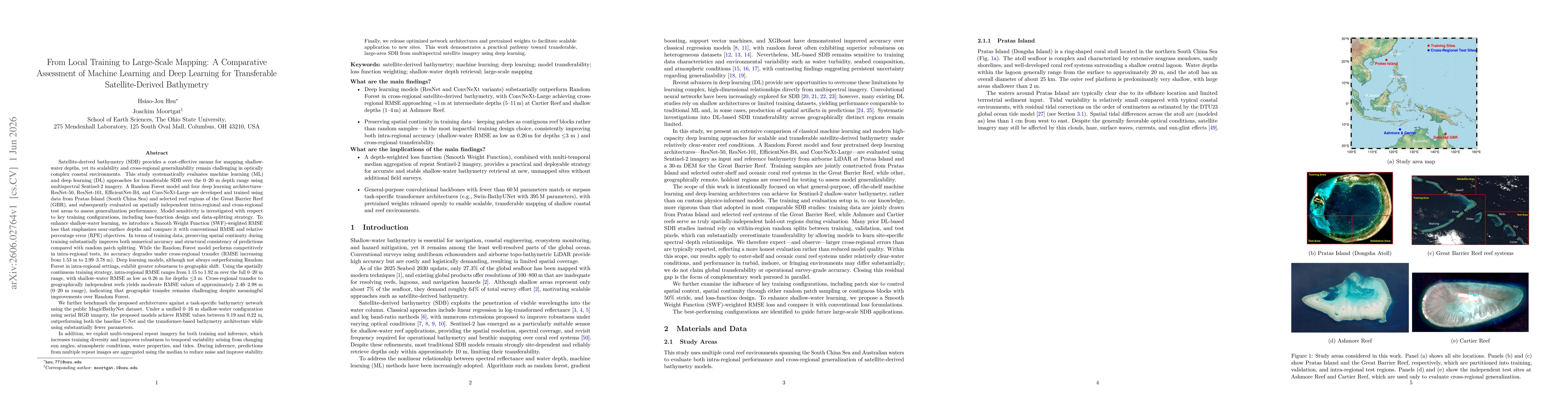
Satellite-derived bathymetry (SDB) from multispectral imagery is cost-effective but scales poorly across regions, especially in optically complex coastal environments. We evaluate machine learning and deep learning for transferable SDB over the 0-20 m depth range using Sentinel-2 imagery. A Random Forest baseline and four CNNs (ResNet-50, ResNet-101, EfficientNet-B4, ConvNeXt-Large) are trained on Pratas Island and selected Great Barrier Reef regions, then evaluated on spatially independent intra- and cross-regional test areas. Preserving spatial continuity during training, by keeping contiguous reef blocks rather than random patches, is the single most impactful design choice; we further introduce a Smooth Weight Function (SWF)-weighted RMSE loss that emphasizes near-surface depths. With these choices, intra-regional RMSE ranges from 1.15 to 1.92 m over 0-20 m and is as low as 0.26 m for depths <= 3 m. Random Forest degrades sharply under cross-regional transfer (RMSE 1.53 m -> 2.99-3.78 m), while the deep models stay more robust (2.46-2.98 m). On the public MagicBathyNet aerial-RGB benchmark (0-16 m) the proposed networks reach 0.19-0.22 m RMSE, outperforming a U-Net baseline and a task-specific transformer architecture with substantially fewer parameters. We further exploit multi-temporal repeat imagery: training on it broadens diversity, and median-aggregating predictions across passes at inference reduces noise from changing sun angles, atmospheric conditions, water properties, and tides. We release optimized architectures and pretrained weights to enable scalable transfer to new sites.
AI Key Findings
Get AI-generated insights about this paper's methodology, results, significance, and more — seven facets brought into focus.
Discussion 0