Authors
Summary
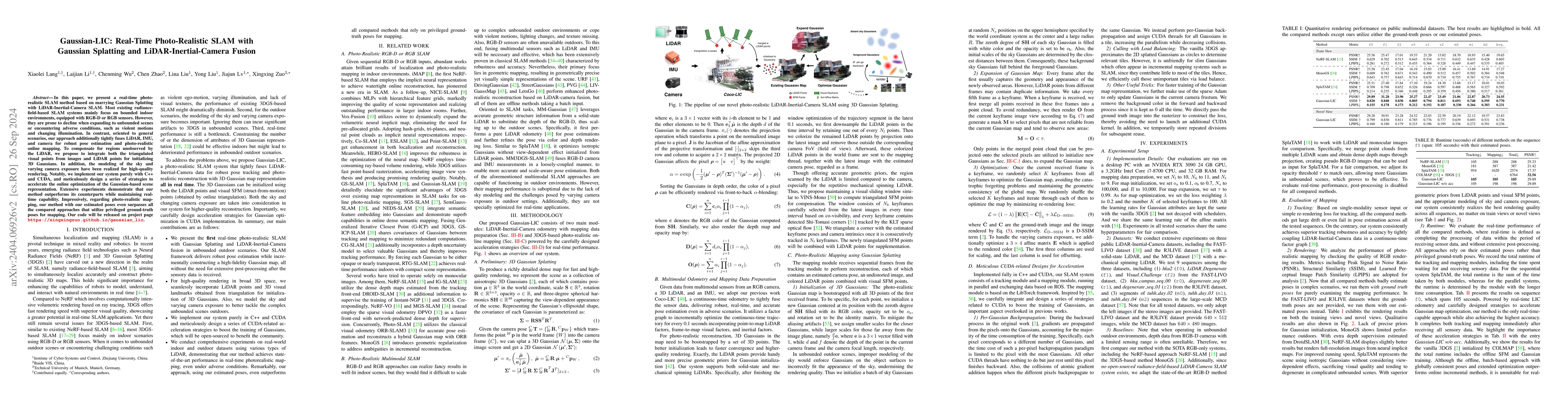
We present a real-time LiDAR-Inertial-Camera SLAM system with 3D Gaussian Splatting as the mapping backend. Leveraging robust pose estimates from our LiDAR-Inertial-Camera odometry, Coco-LIC, an incremental photo-realistic mapping system is proposed in this paper. We initialize 3D Gaussians from colorized LiDAR points and optimize them using differentiable rendering powered by 3D Gaussian Splatting. Meticulously designed strategies are employed to incrementally expand the Gaussian map and adaptively control its density, ensuring high-quality mapping with real-time capability. Experiments conducted in diverse scenarios demonstrate the superior performance of our method compared to existing radiance-field-based SLAM systems.
AI Key Findings
Generated Sep 03, 2025
Methodology
The research presents a real-time LiDAR-Inertial-Camera SLAM system using 3D Gaussian splatting as the mapping backend. It leverages robust pose estimates from Coco-LIC odometry, an incremental photo-realistic mapping system, initializing 3D Gaussians from colorized LiDAR points and optimizing them using differentiable rendering.
Key Results
- Superior performance compared to existing radiance-field-based SLAM systems in diverse scenarios.
- Consistently superior tracking robustness and accuracy by tightly coupling LiDAR-Inertial-Camera data in a continuous-time factor graph.
- Achieves the best rendering quality across all sequences on training views and surpasses other methods even at novel views.
Significance
This research is significant as it introduces a real-time, photo-realistic SLAM system specifically designed to overcome challenges in unbounded outdoor scenes and challenging conditions such as rapid motion and fluctuating lighting, unlike previous radiance-field-based SLAM systems primarily designed for indoor scenes with RGB-D or RGB sensors.
Technical Contribution
The proposed Gaussian-LIC method integrates LiDAR, IMU, and camera data for real-time, photo-realistic SLAM with optimized strategies for fast Gaussian map optimization.
Novelty
Unlike previous works, Gaussian-LIC offers superior performance in unbounded outdoor environments by fusing LiDAR and IMU data, modeling camera exposures, incorporating visual SFM points, and handling sky modeling for enhanced rendering.
Limitations
- Evaluation is conducted on desktop PC hardware, which may not represent real-world embedded system performance.
- Does not address potential scalability issues for very large-scale environments.
Future Work
- Enhance the accuracy of odometry using the reconstructed Gaussian map.
- Improve geometrical reconstruction quality.
Paper Details
PDF Preview
Key Terms
Citation Network
Current paper (gray), citations (green), references (blue)
Display is limited for performance on very large graphs.
Similar Papers
Found 4 papersGaussian-LIC2: LiDAR-Inertial-Camera Gaussian Splatting SLAM
Yong Liu, Jianxin Huang, Xingxing Zuo et al.
Gaussian-SLAM: Photo-realistic Dense SLAM with Gaussian Splatting
Yue Li, Theo Gevers, Martin R. Oswald et al.
GS-LIVM: Real-Time Photo-Realistic LiDAR-Inertial-Visual Mapping with Gaussian Splatting
Jun Ma, Jin Wu, Yusen Xie et al.
LVI-GS: Tightly-coupled LiDAR-Visual-Inertial SLAM using 3D Gaussian Splatting
Peng Lu, Weipeng Guan, Huibin Zhao
No citations found for this paper.
Comments (0)