LVI-GS: Tightly-coupled LiDAR-Visual-Inertial SLAM using 3D Gaussian Splatting
Publication
Metrics
AI Quick Summary
The paper introduces LVI-GS, a tightly-coupled LiDAR-Visual-Inertial SLAM framework utilizing 3D Gaussian Splatting for real-time, high-fidelity 3D scene mapping, leveraging LiDAR and image data for enhanced feature perception and rendering efficiency. The method employs a pyramid-based training and depth loss optimization to achieve superior reconstruction performance compared to existing systems.
Paper Preview
Abstract
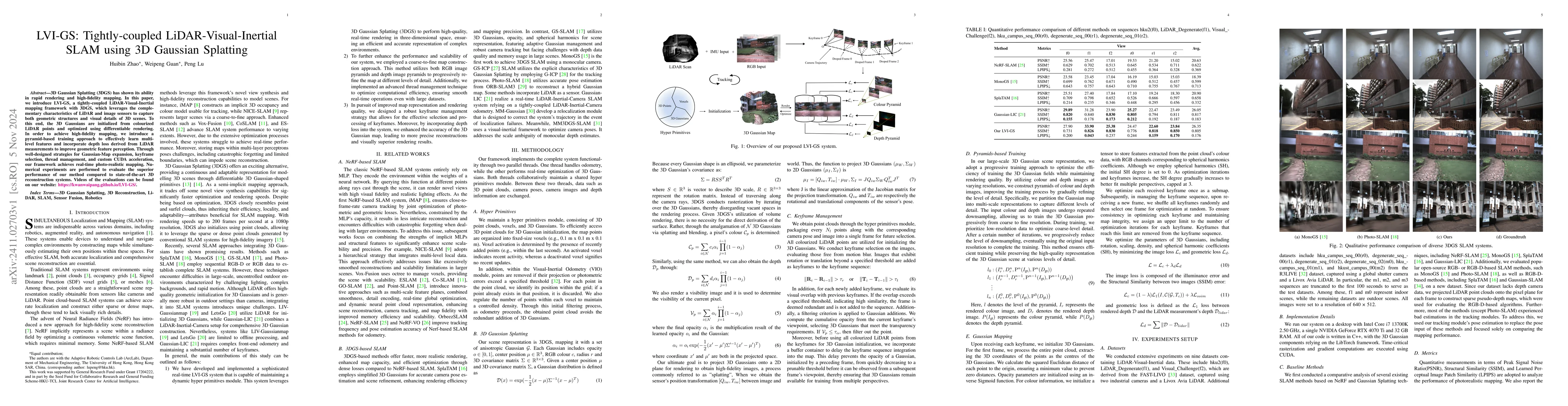
3D Gaussian Splatting (3DGS) has shown its ability in rapid rendering and high-fidelity mapping. In this paper, we introduce LVI-GS, a tightly-coupled LiDAR-Visual-Inertial mapping framework with 3DGS, which leverages the complementary characteristics of LiDAR and image sensors to capture both geometric structures and visual details of 3D scenes. To this end, the 3D Gaussians are initialized from colourized LiDAR points and optimized using differentiable rendering. In order to achieve high-fidelity mapping, we introduce a pyramid-based training approach to effectively learn multi-level features and incorporate depth loss derived from LiDAR measurements to improve geometric feature perception. Through well-designed strategies for Gaussian-Map expansion, keyframe selection, thread management, and custom CUDA acceleration, our framework achieves real-time photo-realistic mapping. Numerical experiments are performed to evaluate the superior performance of our method compared to state-of-the-art 3D reconstruction systems.
AI Key Findings
Get AI-generated insights about this paper's methodology, results, significance, and more — seven facets brought into focus.
Impact
Authors
PDF Preview
Citation Network
Current paper (gray), citations (green), references (blue)
Display is limited for performance on very large graphs.
Discussion 0