GS-GVINS: A Tightly-integrated GNSS-Visual-Inertial Navigation System Augmented by 3D Gaussian Splatting

Source: ArXiv

AI Quick Summary

GS-GVINS integrates GNSS, visual, and inertial sensors with 3D Gaussian Splatting for large-scale outdoor navigation, enhancing performance through a continuous differentiable 3D Gaussian map. The system introduces a motion-aware pruning mechanism to maintain 3DGS quality, validated across open-sky, sub-urban, and urban environments.

Share: Share on X LinkedIn

Summary

Recently, the emergence of 3D Gaussian Splatting (3DGS) has drawn significant attention in the area of 3D map reconstruction and visual SLAM. While extensive research has explored 3DGS for indoor trajectory tracking using visual sensor alone or in combination with Light Detection and Ranging (LiDAR) and Inertial Measurement Unit (IMU), its integration with GNSS for large-scale outdoor navigation remains underexplored. To address these concerns, we proposed GS-GVINS: a tightly-integrated GNSS-Visual-Inertial Navigation System augmented by 3DGS. This system leverages 3D Gaussian as a continuous differentiable scene representation in largescale outdoor environments, enhancing navigation performance through the constructed 3D Gaussian map. Notably, GS-GVINS is the first GNSS-Visual-Inertial navigation application that directly utilizes the analytical jacobians of SE3 camera pose with respect to 3D Gaussians. To maintain the quality of 3DGS rendering in extreme dynamic states, we introduce a motionaware 3D Gaussian pruning mechanism, updating the map based on relative pose translation and the accumulated opacity along the camera ray. For validation, we test our system under different driving environments: open-sky, sub-urban, and urban. Both self-collected and public datasets are used for evaluation. The results demonstrate the effectiveness of GS-GVINS in enhancing navigation accuracy across diverse driving environments.
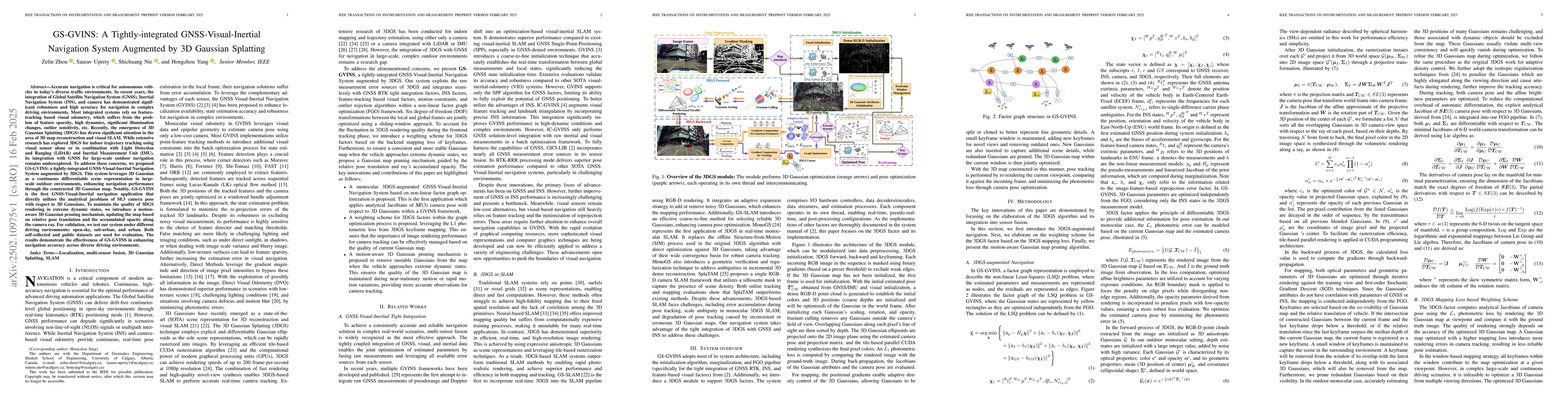
AI Key Findings

Generated Jun 11, 2025

Methodology

The paper proposes GS-GVINS, a tightly-integrated GNSS-Visual-Inertial Navigation System augmented by 3D Gaussian Splatting (3DGS). It employs a factor graph representation for non-linear least-squares problem, optimizing 3D Gaussian parameters independently from the factor graph optimization. The system utilizes analytical Jacobians of SE(3) camera pose with respect to 3D Gaussians, derived from previous work.

Key Results

  • GS-GVINS outperforms GICI-LIB and IC-GVINS in translation estimation, especially in sub-urban and urban environments.
  • The motion-aware 3D Gaussian pruning mechanism improves mapping quality during extreme vehicle dynamics, enhancing pose estimation accuracy in both low- and high-dynamic motion scenarios.
  • 3DGS demonstrates robustness in handling challenging conditions such as extreme exposure, featureless scenes, and shadowed areas, which typically degrade feature-tracking-based navigation.

Significance

This research is significant as it proposes a novel navigation system that improves translation accuracy over existing sensor-fusion libraries, GS-GVINS. It also highlights the robustness of 3DGS in handling challenging conditions, which can benefit real-time navigation systems.

Technical Contribution

The main technical contribution is the development of GS-GVINS, a tightly-integrated GNSS-Visual-Inertial Navigation System augmented by 3D Gaussian Splatting, which includes a mapping loss-based weighting scheme for 3DGS factor and a motion-aware Gaussian pruning mechanism.

Novelty

The novelty of this work lies in the integration of 3D Gaussian Splatting with GNSS-Visual-Inertial Navigation Systems, the use of analytical Jacobians of SE(3) camera pose with respect to 3D Gaussians, and the motion-aware 3D Gaussian pruning mechanism for improved mapping quality during extreme vehicle dynamics.

Limitations

  • The depth initialization strategy for the monocular setting may introduce rotation scale errors, limiting the accuracy of 3D rotation estimation in GS-GVINS.
  • The paper does not discuss scalability of the proposed method for very large-scale environments or its performance in dynamic environments with rapidly changing features.

Future Work

  • Investigate methods to improve rotation estimation accuracy in GS-GVINS.
  • Explore the scalability of the proposed method for even larger and more complex outdoor environments.

Paper Details

PDF Preview

Download PDF

No citations found for this paper.

Comments (0)

This website uses cookies to ensure you get the best experience. Learn more