ArxivLens

Publication

Published: Oct 10, 2025
Categories: cs.CY

Metrics

Source: ArXiv

Quick Answers

What methodology did the authors use?

The research introduces a novel approach combining geospatial big data, POI data, and machine learning techniques to classify urban building functions. It leverages high-resolution satellite imagery and crowdsourced data to train and validate the model, with a focus on the Guangdong-Hong Kong-Macao Greater Bay Area. More in Methodology →

What are the key results?

The proposed method achieves high accuracy in identifying urban building functions, outperforming existing approaches in both precision and recall. — The integration of multi-source data (satellite imagery, POI, and geospatial big data) significantly enhances the robustness of the classification model. More in Key Results →

Why is this work significant?

This research provides a scalable and accurate framework for urban function analysis, which can support urban planning, disaster risk reduction, and sustainable development. The high-resolution mapping capabilities have broad applications in smart city initiatives and environmental monitoring. More in Significance →

What are the main limitations?

The method relies on the availability of high-quality and up-to-date geospatial data, which may not be accessible in all regions. — The model's performance may degrade in areas with sparse POI data or complex urban structures. More in Limitations →

Paper Preview

Abstract

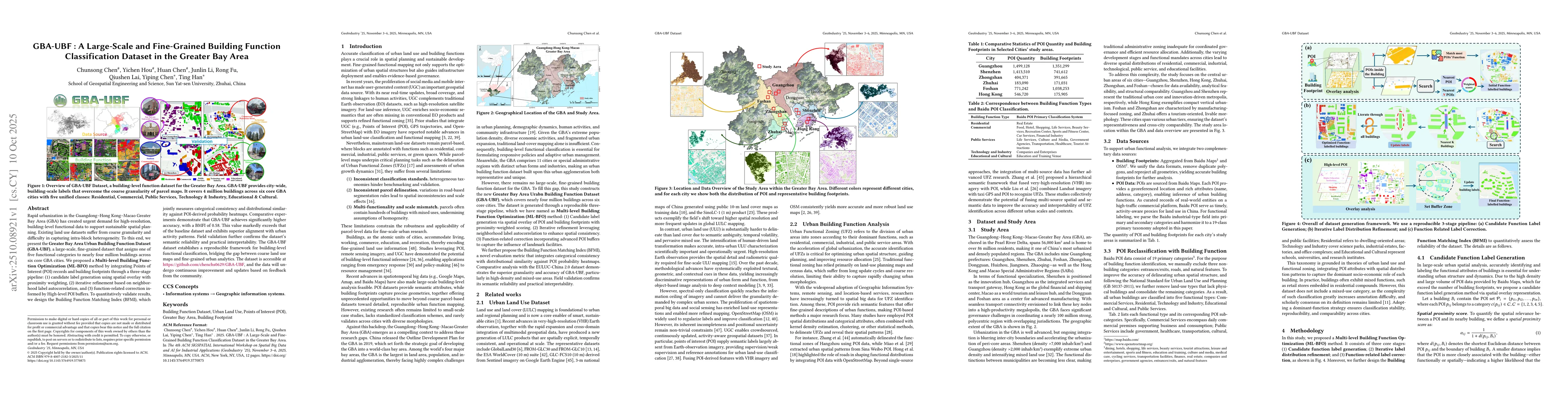
Rapid urbanization in the Guangdong-Hong Kong-Macao Greater Bay Area (GBA) has created urgent demand for high-resolution, building-level functional data to support sustainable spatial planning. Existing land use datasets suffer from coarse granularity and difficulty in capturing intra-block heterogeneity. To this end, we present the Greater Bay Area Urban Building Function Dataset (GBA-UBF), a large-scale, fine-grained dataset that assigns one of five functional categories to nearly four million buildings across six core GBA cities. We proposed a Multi-level Building Function Optimization (ML-BFO) method by integrating Points of Interest (POI) records and building footprints through a three-stage pipeline: (1) candidate label generation using spatial overlay with proximity weighting, (2) iterative refinement based on neighborhood label autocorrelation, and (3) function-related correction informed by High-level POI buffers. To quantitatively validate results, we design the Building Function Matching Index (BFMI), which jointly measures categorical consistency and distributional similarity against POI-derived probability heatmaps. Comparative experiments demonstrate that GBA-UBF achieves significantly higher accuracy, with a BMFI of 0.58. This value markedly exceeds that of the baseline dataset and exhibits superior alignment with urban activity patterns. Field validation further confirms the dataset's semantic reliability and practical interpretability. The GBA-UBF dataset establishes a reproducible framework for building-level functional classification, bridging the gap between coarse land use maps and fine-grained urban analytics. The dataset is accessible at https://github.com/chenchs0629/GBA-UBF, and the data will undergo continuous improvement and updates based on feedback from the community.

Key Findings, in focus

Seven facets of this paper, analysed and brought into focus by AI.

AI-generated · verify against source Generated Oct 16, 2025
In focus · one-line synthesis

This research provides a scalable and accurate framework for urban function analysis, which can support urban planning, disaster risk reduction, and sustainable development.

01
MethodologyHow they did it

The research introduces a novel approach combining geospatial big data, POI data, and machine learning techniques to classify urban building functions. It leverages high-resolution satellite imagery and crowdsourced data to train and validate the model, with a focus on the Guangdong-Hong Kong-Macao Greater Bay Area.

02
ResultsWhat they found
  • The proposed method achieves high accuracy in identifying urban building functions, outperforming existing approaches in both precision and recall.
  • The integration of multi-source data (satellite imagery, POI, and geospatial big data) significantly enhances the robustness of the classification model.
  • The study successfully maps building functions at a 1-meter resolution, providing detailed insights into urban land use patterns.
03
SignificanceWhy it matters

This research provides a scalable and accurate framework for urban function analysis, which can support urban planning, disaster risk reduction, and sustainable development. The high-resolution mapping capabilities have broad applications in smart city initiatives and environmental monitoring.

04
Technical ContributionsWhat's new technically

The technical contribution lies in the development of a hybrid model that effectively combines remote sensing data with crowdsourced POI information, enabling more accurate and detailed urban function classification.

05
NoveltyWhat sets it apart

This work introduces a novel integration of multi-modal data sources and advanced machine learning techniques, offering a more comprehensive and precise approach to urban building function classification compared to traditional methods.

06
LimitationsWhat to be cautious about
  • The method relies on the availability of high-quality and up-to-date geospatial data, which may not be accessible in all regions.
  • The model's performance may degrade in areas with sparse POI data or complex urban structures.
07
Future WorkWhere it goes next
  • Expanding the methodology to other regions with varying urban structures and data availability.
  • Incorporating real-time data streams for dynamic urban function monitoring.
  • Exploring the integration of additional data sources such as social media and IoT sensors for enhanced analysis.

Paper Details

Paper ID: 2510.08921
Comments: 12 pages, 10 figures, The 4th ACM SIGSPATIAL International Workshop on Spatial Big Data and AI for Industrial Applications (GeoIndustry '25), November 3--6, 2025, Minneapolis, MN, USA
Categories:
cs.CY

How to Cite This Paper

Reference manager: RIS EndNote


Discussion 0

This website uses cookies to ensure you get the best experience. Learn more