ArxivLens

Publication

Published: May 01, 2026
Categories: cs.SE, cs.AI

Metrics

Source: ArXiv

Quick Answers

What methodology did the authors use?

GeoContra introduces an executable geospatial contract layer that encodes each GIS task with natural language questions, datasets schemas, CRS metadata, expected outputs, spatial predicates, topology constraints, metrics, required operations, and forbidden shortcuts. It applies a bounded repair loop guided by static rule inspection, runtime validation, and semantic verification to detect and repair geographic violations in LLM-generated Python GIS workflows. More in Methodology →

What are the key results?

On a full closed-model benchmark (7,079 tasks across 15 Boston areas, 9 task families, 11 models), spatial correctness improved from 47.6% to 77.5% for DeepSeek-V4 and from 57.7% to 81.5% for Kimi-K2.5. — Across 11 open models, average spatial correctness increased by 26.6 percentage points, indicating substantial gains in verifiability and geographic validity. More in Key Results →

Why is this work significant?

The framework shifts LLM-GIS evaluation from fluency and executability to verifiable spatial correctness by enforcing geography-grounded contracts, enabling reliable, reproducible spatial analysis at scale and mitigating geographically invalid outcomes in automated GIS workflows. More in Significance →

What are the main limitations?

Evaluation predominantly uses Boston-area data; generalizability to diverse geographies and data sources remains to be validated. — The repair loop may increase computational overhead due to multiple validation passes and contract checks. More in Limitations →

Paper Preview

Abstract

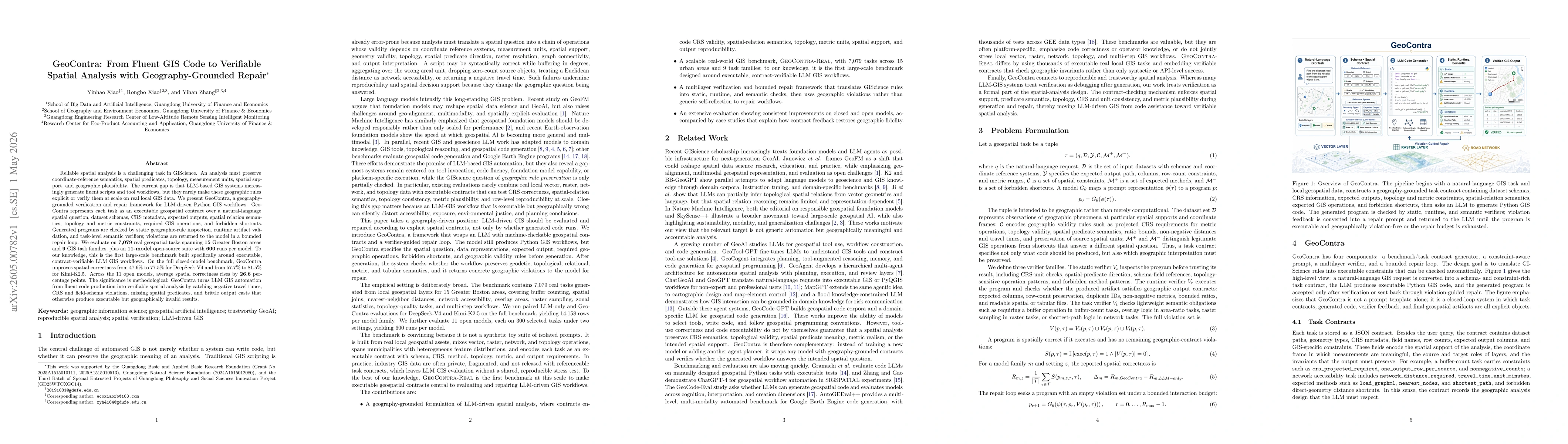
Reliable spatial analysis in GIScience requires preserving coordinate semantics, topology, units, and geographic plausibility. Current LLM-based GIS systems generate fluent scripts but rarely enforce these geographic rules at scale. We present GeoContra, a verification and repair framework for LLM-driven Python GIS workflows. It represents each task as an executable geospatial contract-including natural-language questions, schemas, CRS metadata, expected outputs, spatial predicates, topology, metrics, required operations, and forbidden shortcuts. Generated programs undergo static rule inspection, runtime validation, and semantic verification, with violations fed back into a bounded repair loop. Evaluated on 7,079 real geospatial tasks across 15 Boston-area zones, 9 task families, and 11 open-source models (600 runs each), GeoContra improves spatial correctness on closed models from 47.6% to 77.5% for DeepSeek-V4 and from 57.7% to 81.5% for Kimi-K2.5. Across 11 open models, average correctness rises by 26.6%. GeoContra turns fluent code production into verifiable spatial analysis, catching negative travel times, CRS/field-schema violations, missing predicates, and brittle output casts that otherwise yield executable but geographically invalid results.

Key Findings, in focus

Seven facets of this paper, analysed and brought into focus by AI.

AI-generated · verify against source Generated May 05, 2026
In focus · one-line synthesis

The framework shifts LLM-GIS evaluation from fluency and executability to verifiable spatial correctness by enforcing geography-grounded contracts, enabling reliable, reproducible spatial analysis at scale and mitigating geographically invalid outcomes in automated GIS workflows.

01
MethodologyHow they did it

GeoContra introduces an executable geospatial contract layer that encodes each GIS task with natural language questions, datasets schemas, CRS metadata, expected outputs, spatial predicates, topology constraints, metrics, required operations, and forbidden shortcuts. It applies a bounded repair loop guided by static rule inspection, runtime validation, and semantic verification to detect and repair geographic violations in LLM-generated Python GIS workflows.

02
ResultsWhat they found
  • On a full closed-model benchmark (7,079 tasks across 15 Boston areas, 9 task families, 11 models), spatial correctness improved from 47.6% to 77.5% for DeepSeek-V4 and from 57.7% to 81.5% for Kimi-K2.5.
  • Across 11 open models, average spatial correctness increased by 26.6 percentage points, indicating substantial gains in verifiability and geographic validity.
  • GeoContra detects and corrects issues such as negative travel times, CRS/field-schema violations, missing predicates, and brittle output casts that would otherwise yield executable but geographically invalid results.
03
SignificanceWhy it matters

The framework shifts LLM-GIS evaluation from fluency and executability to verifiable spatial correctness by enforcing geography-grounded contracts, enabling reliable, reproducible spatial analysis at scale and mitigating geographically invalid outcomes in automated GIS workflows.

04
Technical ContributionsWhat's new technically

A geography-grounded verification and repair framework (GeoContra) that converts LLM-generated GIS workflows into executable geospatial contracts with explicit CRS, topology, predicates, and validity rules, enabling static inspection, runtime validation, and semantic verification with bounded repair feedback.

05
NoveltyWhat sets it apart

First large-scale benchmark and framework to combine executable geospatial contracts with automated repair loops, rigorously testing geographic rule preservation (CRS, topology, units, and spatial semantics) across multiple models and real-world GIS tasks.

06
LimitationsWhat to be cautious about
  • Evaluation predominantly uses Boston-area data; generalizability to diverse geographies and data sources remains to be validated.
  • The repair loop may increase computational overhead due to multiple validation passes and contract checks.
  • Dependence on the quality of initial contracts; errors in contract specifications could propagate if not properly identified.
07
Future WorkWhere it goes next
  • Extend benchmarking to additional cities and rural/urban contexts to test generalization.
  • Optimize contract encoding and verification efficiency to reduce runtime costs.
  • Incorporate user-in-the-loop feedback for continuous improvement of geographic rules and repair strategies.

Paper Details

Paper ID: 2605.00782
Categories:
cs.SE cs.AI

How to Cite This Paper

Reference manager: RIS EndNote

Related Papers

4 found


Discussion 0

This website uses cookies to ensure you get the best experience. Learn more