GIS Copilot: Towards an Autonomous GIS Agent for Spatial Analysis
Publication
Metrics
AI Quick Summary
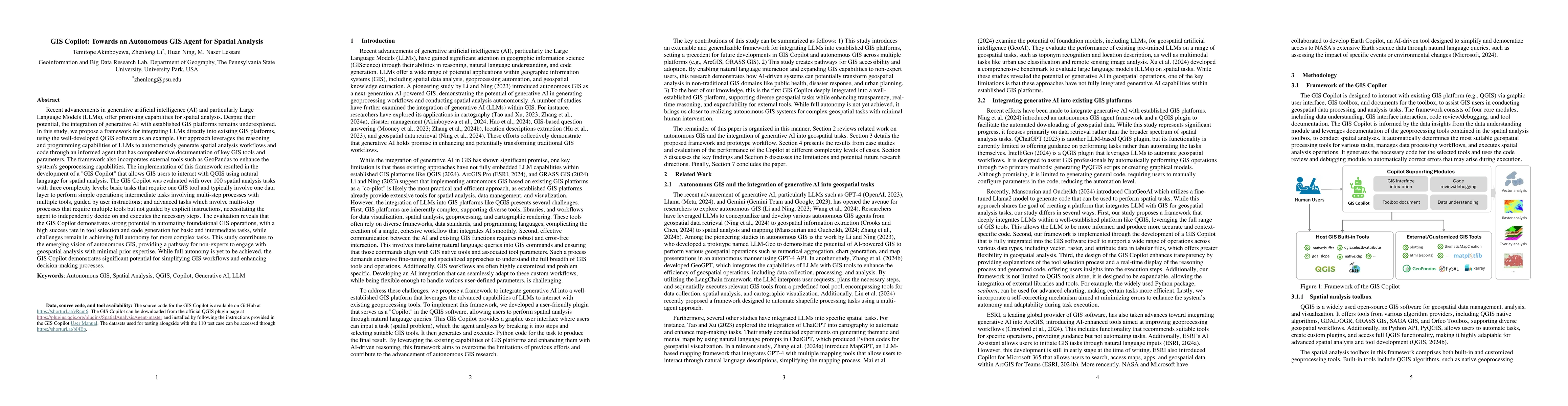
This paper proposes a framework integrating large language models (LLMs) into GIS platforms, specifically QGIS, to create an autonomous GIS agent called GIS Copilot. The GIS Copilot enables natural language interaction for spatial analysis, automating simple to intermediate tasks with high success rates but facing challenges in fully autonomous complex task execution.
Paper Preview
Abstract
Recent advancements in Generative AI offer promising capabilities for spatial analysis. Despite their potential, the integration of generative AI with established GIS platforms remains underexplored. In this study, we propose a framework for integrating LLMs directly into existing GIS platforms, using QGIS as an example. Our approach leverages the reasoning and programming capabilities of LLMs to autonomously generate spatial analysis workflows and code through an informed agent that has comprehensive documentation of key GIS tools and parameters. The implementation of this framework resulted in the development of a "GIS Copilot" that allows GIS users to interact with QGIS using natural language commands for spatial analysis. The GIS Copilot was evaluated based on three complexity levels: basic tasks that require one GIS tool and typically involve one data layer to perform simple operations; intermediate tasks involving multi-step processes with multiple tools, guided by user instructions; and advanced tasks which involve multi-step processes that require multiple tools but not guided by user instructions, necessitating the agent to independently decide on and executes the necessary steps. The evaluation reveals that the GIS Copilot demonstrates strong potential in automating foundational GIS operations, with a high success rate in tool selection and code generation for basic and intermediate tasks, while challenges remain in achieving full autonomy for more complex tasks. This study contributes to the emerging vision of Autonomous GIS, providing a pathway for non-experts to engage with geospatial analysis with minimal prior expertise. While full autonomy is yet to be achieved, the GIS Copilot demonstrates significant potential for simplifying GIS workflows and enhancing decision-making processes.
AI Key Findings
Get AI-generated insights about this paper's methodology, results, significance, and more — seven facets brought into focus.
Authors
PDF Preview
Related Papers
No references found for this paper.
Discussion 0