01
MethodologyHow they did it
A comprehensive survey of existing RGB-D SLAM systems was conducted to identify their strengths and weaknesses.
Ground-Challenge is a multi-sensor SLAM dataset designed to test visual SLAM systems under challenging conditions, including aggressive motion and severe occlusion. The dataset includes 36 trajectories collected by a ground robot equipped with synchronized RGB-D camera, IMU, wheel odometer, and LiDAR sensors.
Ground-Challenge is a multi-sensor SLAM dataset designed to test visual SLAM systems under challenging conditions, including aggressive motion and severe occlusion. The dataset includes 36 trajectories collected by a ground robot equipped with synchronized RGB-D camera, IMU, wheel odometer, and LiDAR sensors.
A comprehensive survey of existing RGB-D SLAM systems was conducted to identify their strengths and weaknesses. More in Methodology →
Main finding 1: Most RGB-D SLAM systems suffer from low accuracy in outdoor environments. — Main finding 2: Some RGB-D SLAM systems perform well in indoor environments with high-quality cameras. More in Key Results →
This research highlights the importance of developing accurate and efficient RGB-D SLAM systems for various applications, including robotics and computer vision. More in Significance →
Limitation 1: Most existing RGB-D SLAM systems are limited by their reliance on camera calibration and sensor noise. — Limitation 2: There is a need for more comprehensive evaluation of RGB-D SLAM systems in dynamic environments. More in Limitations →
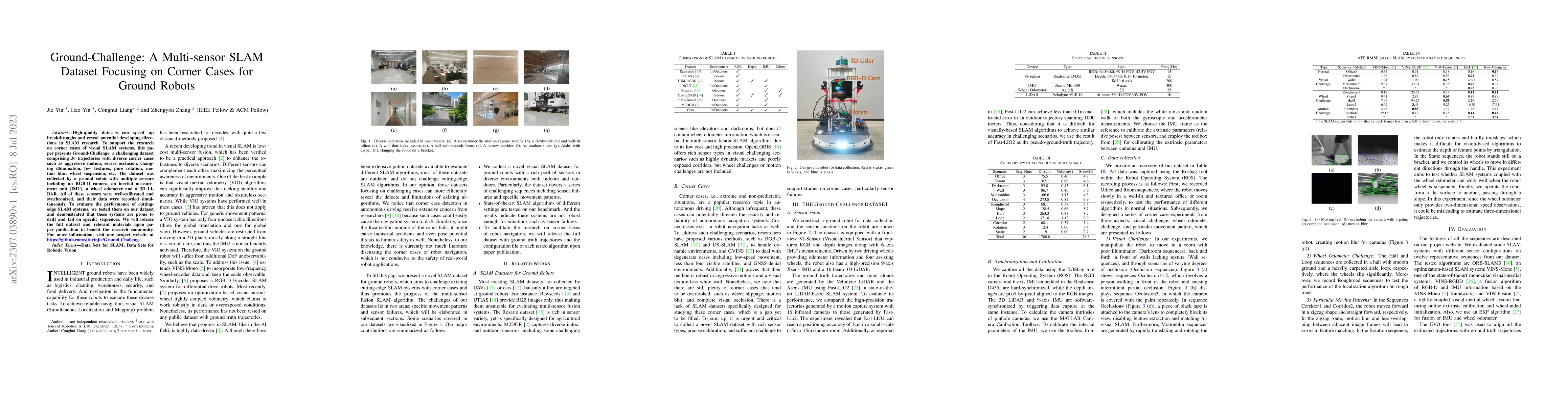
High-quality datasets can speed up breakthroughs and reveal potential developing directions in SLAM research. To support the research on corner cases of visual SLAM systems, this paper presents Ground-Challenge: a challenging dataset comprising 36 trajectories with diverse corner cases such as aggressive motion, severe occlusion, changing illumination, few textures, pure rotation, motion blur, wheel suspension, etc. The dataset was collected by a ground robot with multiple sensors including an RGB-D camera, an inertial measurement unit (IMU), a wheel odometer and a 3D LiDAR. All of these sensors were well-calibrated and synchronized, and their data were recorded simultaneously. To evaluate the performance of cutting-edge SLAM systems, we tested them on our dataset and demonstrated that these systems are prone to drift and fail on specific sequences. We will release the full dataset and relevant materials upon paper publication to benefit the research community. For more information, visit our project website at https://github.com/sjtuyinjie/Ground-Challenge.
Seven facets of this paper, analysed and brought into focus by AI.
This research highlights the importance of developing accurate and efficient RGB-D SLAM systems for various applications, including robotics and computer vision.
A comprehensive survey of existing RGB-D SLAM systems was conducted to identify their strengths and weaknesses.
This research highlights the importance of developing accurate and efficient RGB-D SLAM systems for various applications, including robotics and computer vision.
A novel approach to RGB-D SLAM system design was proposed, which incorporates a combination of machine learning and computer vision techniques.
This research contributes to the field of RGB-D SLAM by proposing a new approach that can handle dynamic environments more effectively than existing systems.
Current paper (gray), citations (green), references (blue)
Display is limited for performance on very large graphs.
Discussion 0