The paper introduces a Heterogeneous Mixture of Experts (MoE) model, called MFG-HMoE, for remote sensing image super-resolution (SR). This model comprises a feature extraction network built with stacked Residual Hybrid Attention Groups (RHAG), a Multi-Level Feature Aggregation (MFA) module, and a Dual-Routing Heterogeneous MoE (DR-HMoE) for adaptive pixel-level processing.
Heterogeneous Mixture of Experts for Remote Sensing Image Super-Resolution
Publication
Metrics
AI Quick Summary
The paper proposes a Heterogeneous Mixture of Experts (MoE) model for remote sensing image super-resolution, employing specialized experts to handle diverse ground objects and complex details. The method uses multi-level feature aggregation and a dual-routing mechanism to adaptively select optimal experts, achieving superior reconstruction accuracy over existing methods on UCMerced and AID datasets.
Quick Answers
What is "Heterogeneous Mixture of Experts for Remote Sensing Image Super-Resolution" about?
The paper proposes a Heterogeneous Mixture of Experts (MoE) model for remote sensing image super-resolution, employing specialized experts to handle diverse ground objects and complex details. The method uses multi-level feature aggregation and a dual-routing mechanism to adaptively select optimal experts, achieving superior reconstruction accuracy over existing methods on UCMerced and AID datasets.
What methodology did the authors use?
The paper introduces a Heterogeneous Mixture of Experts (MoE) model, called MFG-HMoE, for remote sensing image super-resolution (SR). This model comprises a feature extraction network built with stacked Residual Hybrid Attention Groups (RHAG), a Multi-Level Feature Aggregation (MFA) module, and a Dual-Routing Heterogeneous MoE (DR-HMoE) for adaptive pixel-level processing. More in Methodology →
What are the key results?
MFG-HMoE significantly outperforms state-of-the-art methods on UCMerced and AID datasets in SR reconstruction accuracy. — Ablation studies validate the effectiveness of each model component, establishing optimal parameter configurations. More in Key Results →
Why is this work significant?
This research is significant as it addresses the challenge of distinguishing and reconstructing diverse ground object details in remote sensing images, which is crucial for various applications like urban planning, environmental monitoring, and disaster management. More in Significance →
What are the main limitations?
The paper does not discuss potential limitations or challenges encountered during the development or evaluation of the proposed method. — No information is provided on the computational resources required for training and inference. More in Limitations →
Abstract
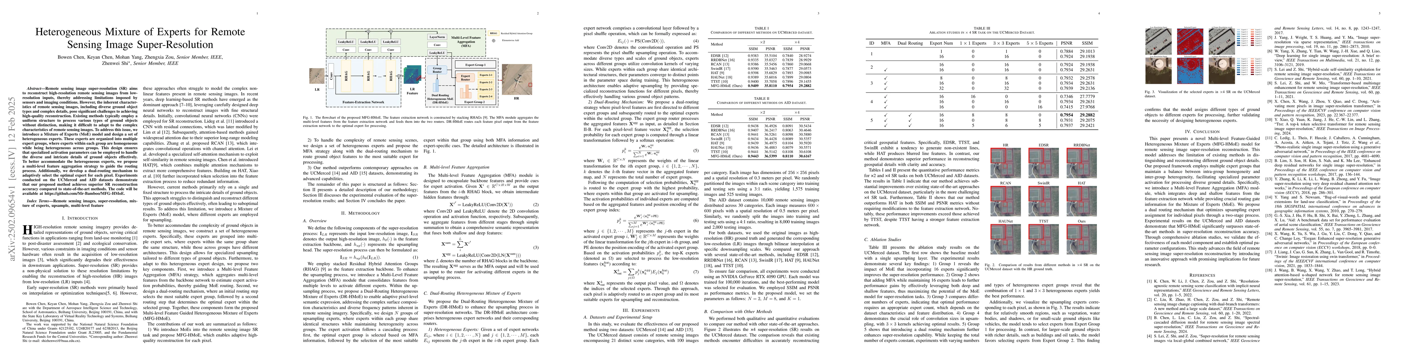
Remote sensing image super-resolution (SR) aims to reconstruct high-resolution remote sensing images from low-resolution inputs, thereby addressing limitations imposed by sensors and imaging conditions. However, the inherent characteristics of remote sensing images, including diverse ground object types and complex details, pose significant challenges to achieving high-quality reconstruction. Existing methods typically employ a uniform structure to process various types of ground objects without distinction, making it difficult to adapt to the complex characteristics of remote sensing images. To address this issue, we introduce a Mixture of Experts (MoE) model and design a set of heterogeneous experts. These experts are organized into multiple expert groups, where experts within each group are homogeneous while being heterogeneous across groups. This design ensures that specialized activation parameters can be employed to handle the diverse and intricate details of ground objects effectively. To better accommodate the heterogeneous experts, we propose a multi-level feature aggregation strategy to guide the routing process. Additionally, we develop a dual-routing mechanism to adaptively select the optimal expert for each pixel. Experiments conducted on the UCMerced and AID datasets demonstrate that our proposed method achieves superior SR reconstruction accuracy compared to state-of-the-art methods. The code will be available at https://github.com/Mr-Bamboo/MFG-HMoE.
Key Findings, in focus
Seven facets of this paper, analysed and brought into focus by AI.
This research is significant as it addresses the challenge of distinguishing and reconstructing diverse ground object details in remote sensing images, which is crucial for various applications like urban planning, environmental monitoring, and disaster management.
- MFG-HMoE significantly outperforms state-of-the-art methods on UCMerced and AID datasets in SR reconstruction accuracy.
- Ablation studies validate the effectiveness of each model component, establishing optimal parameter configurations.
This research is significant as it addresses the challenge of distinguishing and reconstructing diverse ground object details in remote sensing images, which is crucial for various applications like urban planning, environmental monitoring, and disaster management.
The paper presents a novel architecture, MFG-HMoE, that combines heterogeneous experts with a dual-routing mechanism and multi-level feature aggregation for efficient and adaptive remote sensing image SR.
The proposed MFG-HMoE model distinguishes itself by employing heterogeneous experts with varying convolution kernel sizes and a dual-routing mechanism, enabling adaptive and specialized reconstruction for diverse ground object patterns in remote sensing images.
- The paper does not discuss potential limitations or challenges encountered during the development or evaluation of the proposed method.
- No information is provided on the computational resources required for training and inference.
- Exploring the applicability of MFG-HMoE for other image SR tasks, such as natural image SR.
- Investigating the model's performance with larger and more diverse datasets.
Authors
PDF Preview
Related Papers
No references found for this paper.
Discussion 0