Homogeneous Tokenizer Matters: Homogeneous Visual Tokenizer for Remote Sensing Image Understanding
Publication
Metrics
AI Quick Summary
This research introduces HOOK, a novel homogeneous visual tokenizer designed to improve remote sensing image understanding. Unlike patch-based methods, HOOK utilizes semantically independent regions and requires fewer tokens, achieving state-of-the-art performance and efficiency improvements.
Paper Preview
Abstract
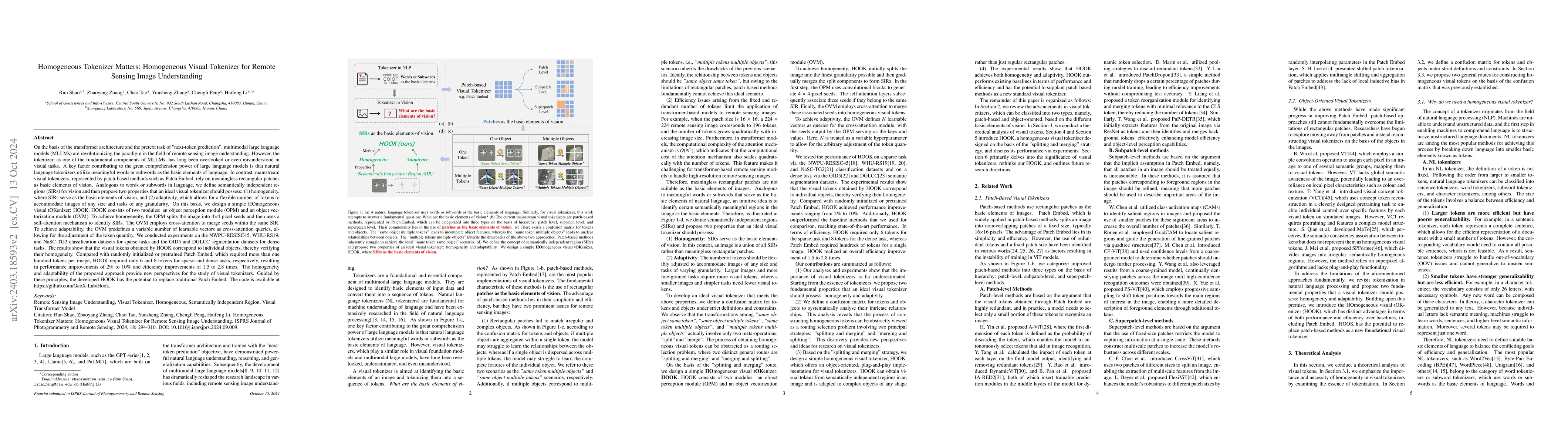
The tokenizer, as one of the fundamental components of large models, has long been overlooked or even misunderstood in visual tasks. One key factor of the great comprehension power of the large language model is that natural language tokenizers utilize meaningful words or subwords as the basic elements of language. In contrast, mainstream visual tokenizers, represented by patch-based methods such as Patch Embed, rely on meaningless rectangular patches as basic elements of vision, which cannot serve as effectively as words or subwords in language. Starting from the essence of the tokenizer, we defined semantically independent regions (SIRs) for vision. We designed a simple HOmogeneous visual tOKenizer: HOOK. HOOK mainly consists of two modules: the Object Perception Module (OPM) and the Object Vectorization Module (OVM). To achieve homogeneity, the OPM splits the image into 4*4 pixel seeds and then utilizes the attention mechanism to perceive SIRs. The OVM employs cross-attention to merge seeds within the same SIR. To achieve adaptability, the OVM defines a variable number of learnable vectors as cross-attention queries, allowing for the adjustment of token quantity. We conducted experiments on the NWPU-RESISC45, WHU-RS19 classification dataset, and GID5 segmentation dataset for sparse and dense tasks. The results demonstrate that the visual tokens obtained by HOOK correspond to individual objects, which demonstrates homogeneity. HOOK outperformed Patch Embed by 6\% and 10\% in the two tasks and achieved state-of-the-art performance compared to the baselines used for comparison. Compared to Patch Embed, which requires more than one hundred tokens for one image, HOOK requires only 6 and 8 tokens for sparse and dense tasks, respectively, resulting in efficiency improvements of 1.5 to 2.8 times. The code is available at https://github.com/GeoX-Lab/Hook.
AI Key Findings
Get AI-generated insights about this paper's methodology, results, significance, and more — seven facets brought into focus.
Impact
Paper Details
Authors
PDF Preview
Key Terms
Citation Network
Current paper (gray), citations (green), references (blue)
Display is limited for performance on very large graphs.
Discussion 0