IceCloudNet: 3D reconstruction of cloud ice from Meteosat SEVIRI
Publication
Metrics
AI Quick Summary
IceCloudNet uses machine learning to predict cloud ice water content and ice crystal concentrations at high spatial and temporal resolution from geostationary satellite data. It significantly expands the availability of vertically resolved cloud profiles, even beyond the lifetime of satellite missions.
Paper Preview
Abstract
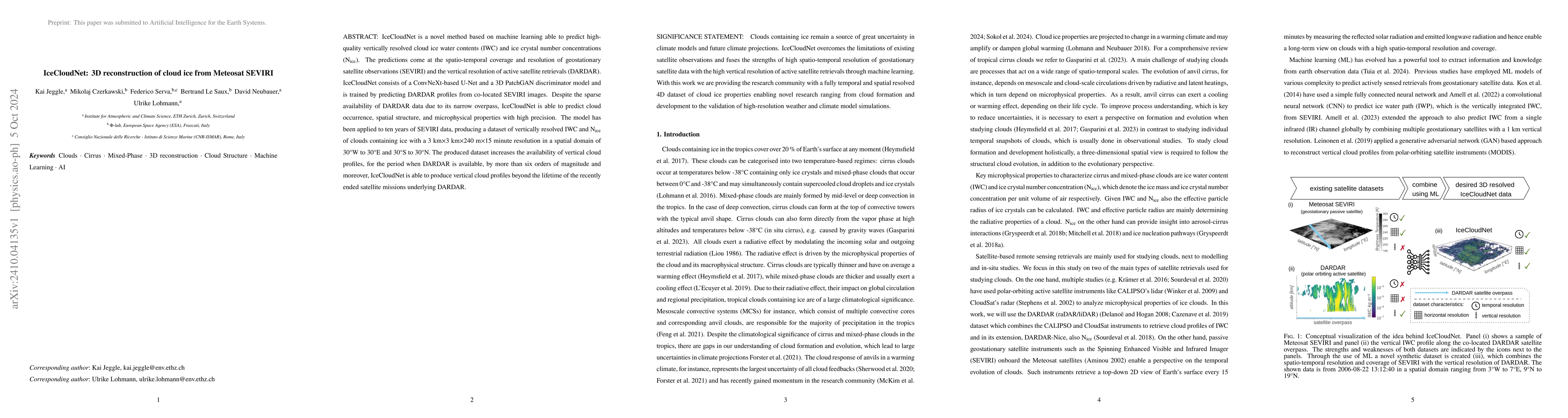
IceCloudNet is a novel method based on machine learning able to predict high-quality vertically resolved cloud ice water contents (IWC) and ice crystal number concentrations (N$_\textrm{ice}$). The predictions come at the spatio-temporal coverage and resolution of geostationary satellite observations (SEVIRI) and the vertical resolution of active satellite retrievals (DARDAR). IceCloudNet consists of a ConvNeXt-based U-Net and a 3D PatchGAN discriminator model and is trained by predicting DARDAR profiles from co-located SEVIRI images. Despite the sparse availability of DARDAR data due to its narrow overpass, IceCloudNet is able to predict cloud occurrence, spatial structure, and microphysical properties with high precision. The model has been applied to ten years of SEVIRI data, producing a dataset of vertically resolved IWC and N$_\textrm{ice}$ of clouds containing ice with a 3 kmx3 kmx240 mx15 minute resolution in a spatial domain of 30{\deg}W to 30{\deg}E and 30{\deg}S to 30{\deg}N. The produced dataset increases the availability of vertical cloud profiles, for the period when DARDAR is available, by more than six orders of magnitude and moreover, IceCloudNet is able to produce vertical cloud profiles beyond the lifetime of the recently ended satellite missions underlying DARDAR.
AI Key Findings
Get AI-generated insights about this paper's methodology, results, significance, and more — seven facets brought into focus.
Impact
Paper Details
Authors
PDF Preview
Citation Network
Current paper (gray), citations (green), references (blue)
Display is limited for performance on very large graphs.
Discussion 0