Academic Profile
Statistics
Similar Authors
Papers on arXiv
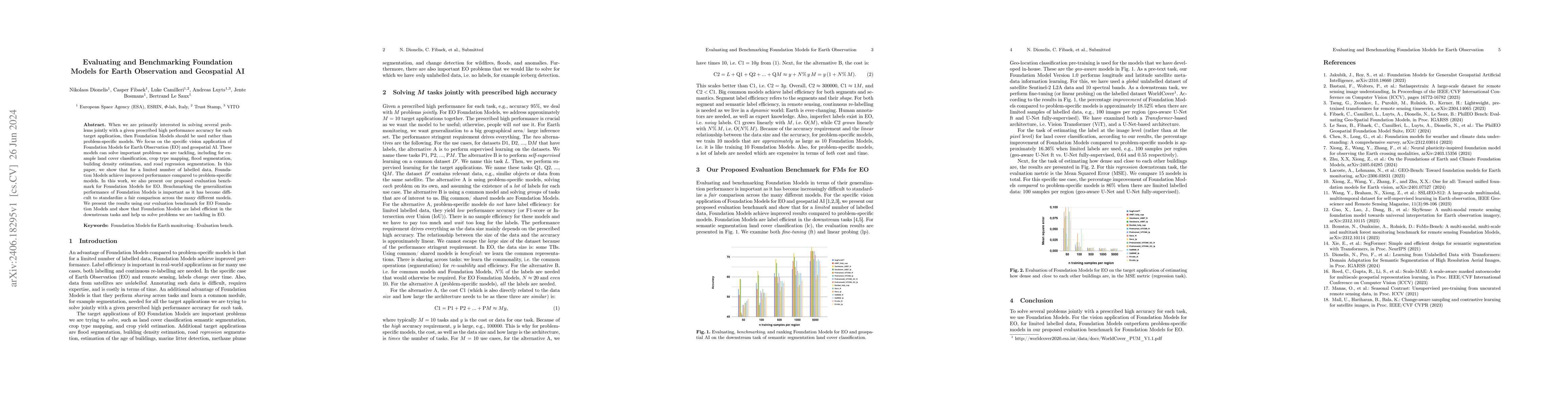
When we are primarily interested in solving several problems jointly with a given prescribed high performance accuracy for each target application, then Foundation Models should for most cases be used...
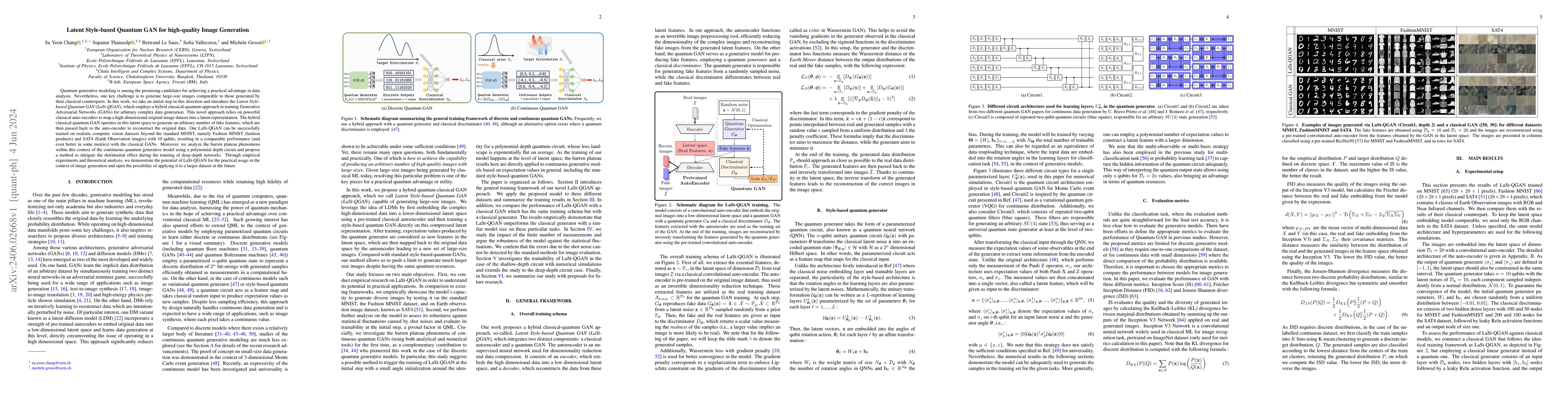
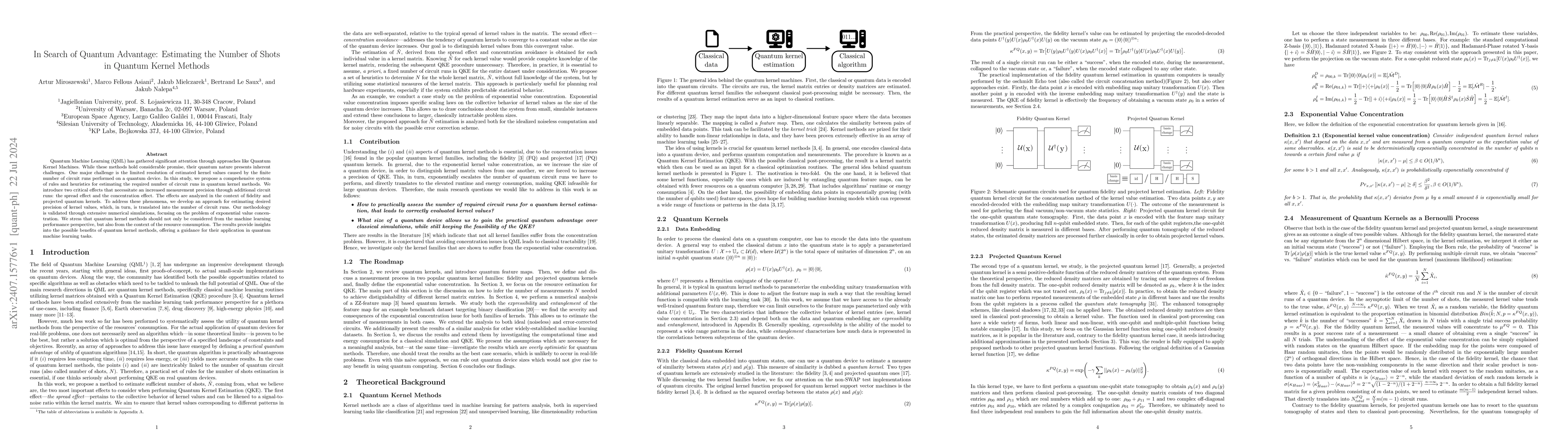
Quantum generative modeling is among the promising candidates for achieving a practical advantage in data analysis. Nevertheless, one key challenge is to generate large-size images comparable to tho...
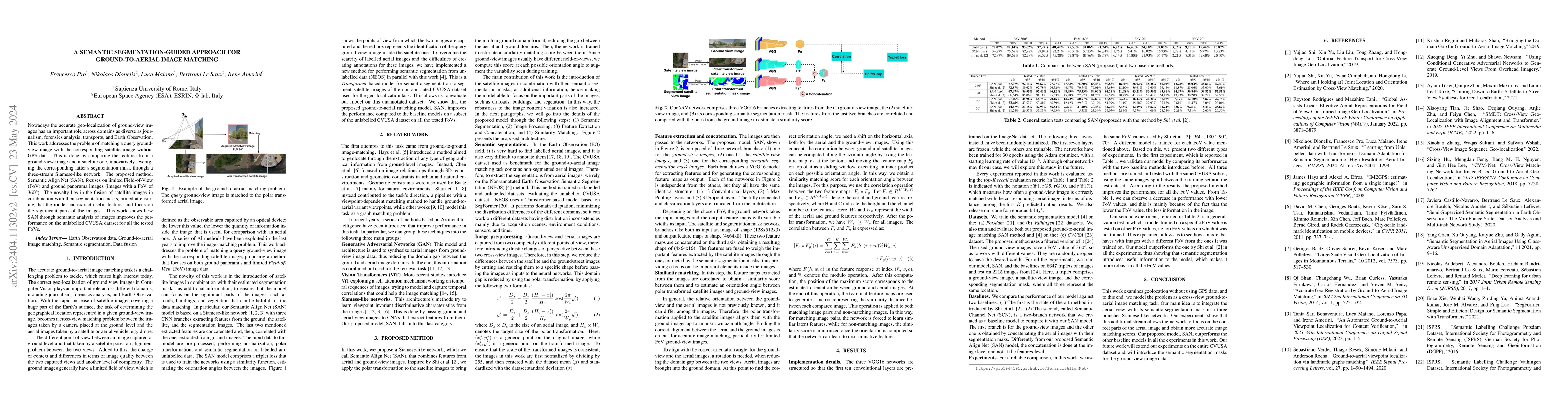
Nowadays the accurate geo-localization of ground-view images has an important role across domains as diverse as journalism, forensics analysis, transports, and Earth Observation. This work addresses...
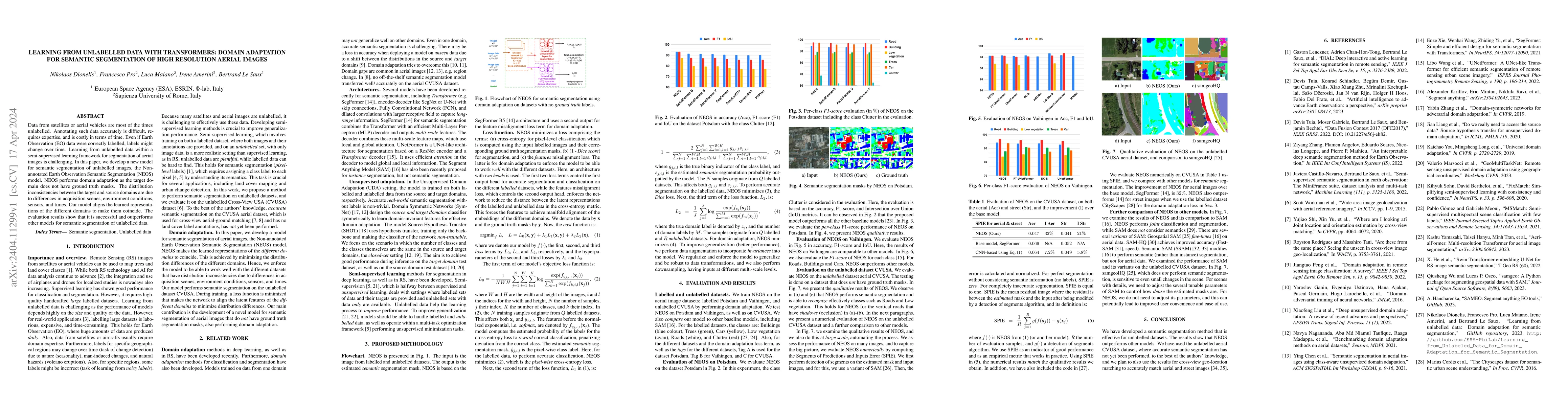
Data from satellites or aerial vehicles are most of the times unlabelled. Annotating such data accurately is difficult, requires expertise, and is costly in terms of time. Even if Earth Observation ...
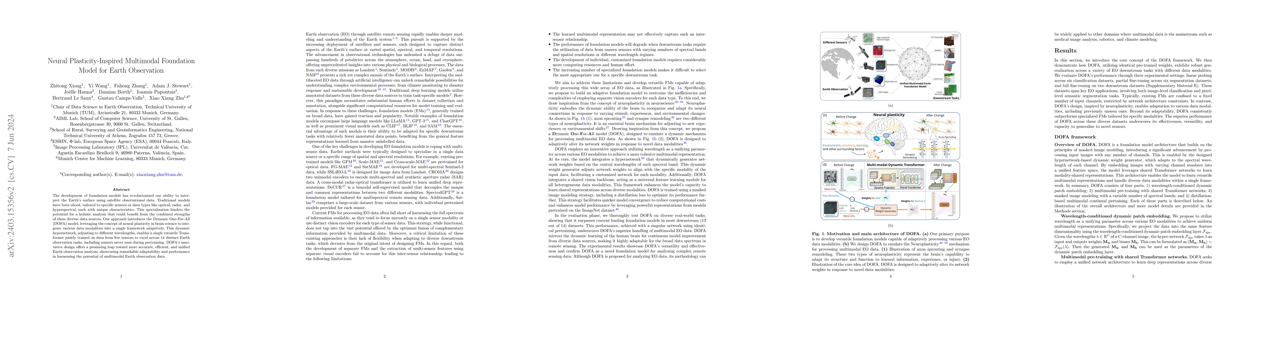
The development of foundation models has revolutionized our ability to interpret the Earth's surface using satellite observational data. Traditional models have been siloed, tailored to specific sen...
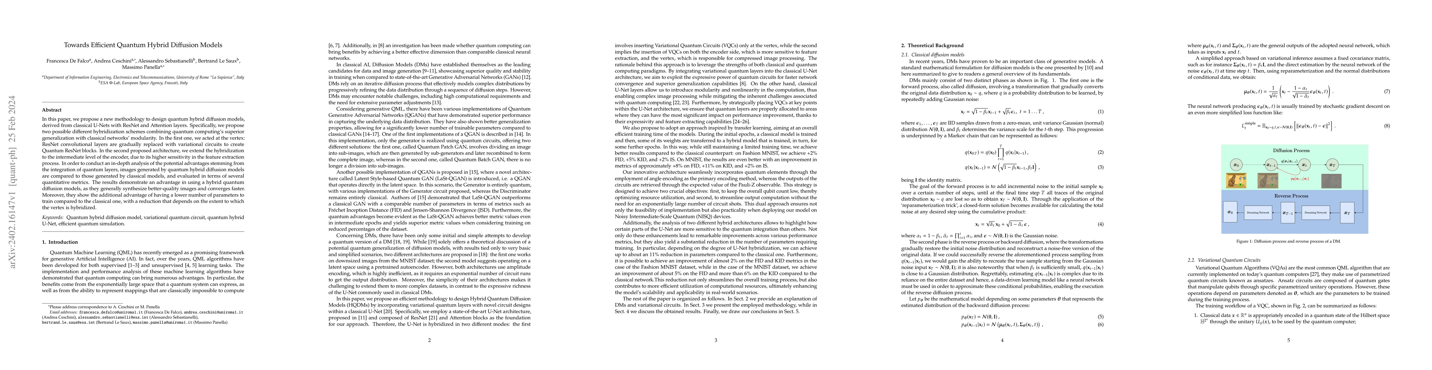
In this paper, we propose a new methodology to design quantum hybrid diffusion models, derived from classical U-Nets with ResNet and Attention layers. Specifically, we propose two possible different...
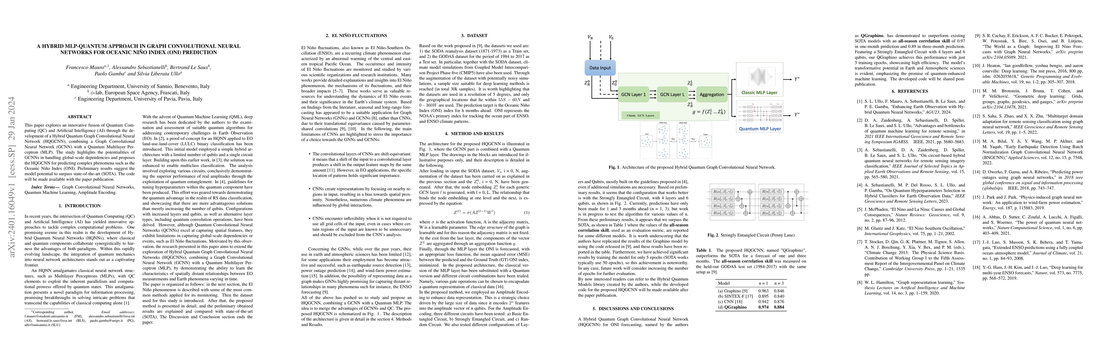
This paper explores an innovative fusion of Quantum Computing (QC) and Artificial Intelligence (AI) through the development of a Hybrid Quantum Graph Convolutional Neural Network (HQGCNN), combining...
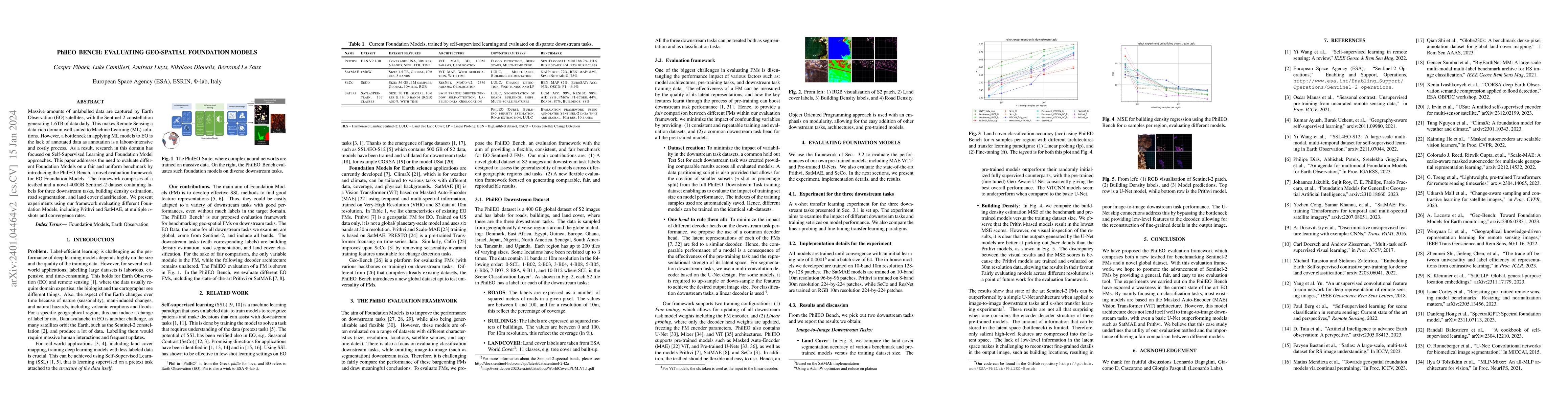
Massive amounts of unlabelled data are captured by Earth Observation (EO) satellites, with the Sentinel-2 constellation generating 1.6 TB of data daily. This makes Remote Sensing a data-rich domain ...
Remote sensing visual question answering (RSVQA) opens new opportunities for the use of overhead imagery by the general public, by enabling human-machine interaction with natural language. Building ...
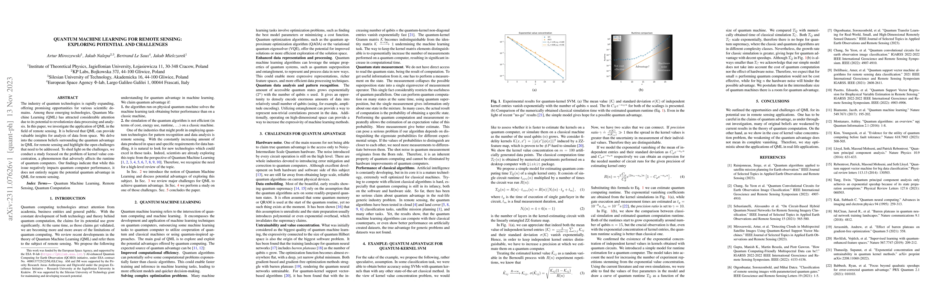
The industry of quantum technologies is rapidly expanding, offering promising opportunities for various scientific domains. Among these emerging technologies, Quantum Machine Learning (QML) has attr...
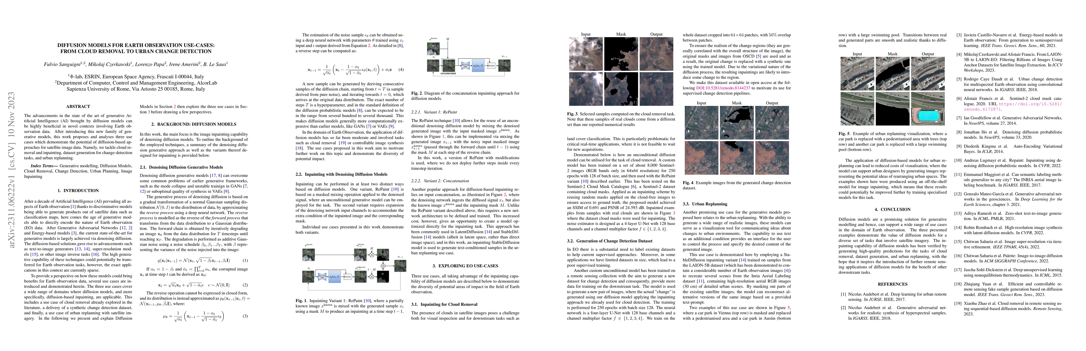
The advancements in the state of the art of generative Artificial Intelligence (AI) brought by diffusion models can be highly beneficial in novel contexts involving Earth observation data. After int...
Clouds containing ice particles play a crucial role in the climate system. Yet they remain a source of great uncertainty in climate models and future climate projections. In this work, we create a n...
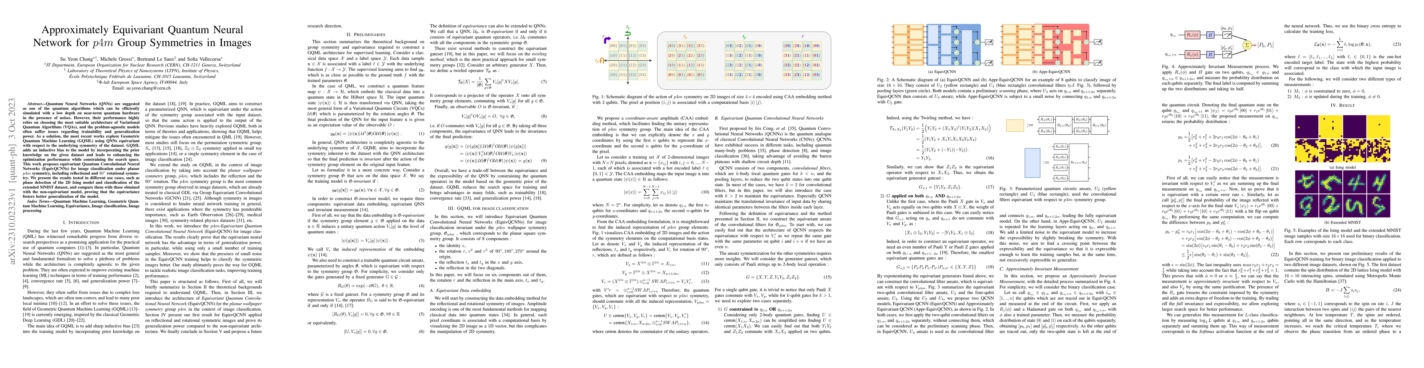
Quantum Neural Networks (QNNs) are suggested as one of the quantum algorithms which can be efficiently simulated with a low depth on near-term quantum hardware in the presence of noises. However, th...
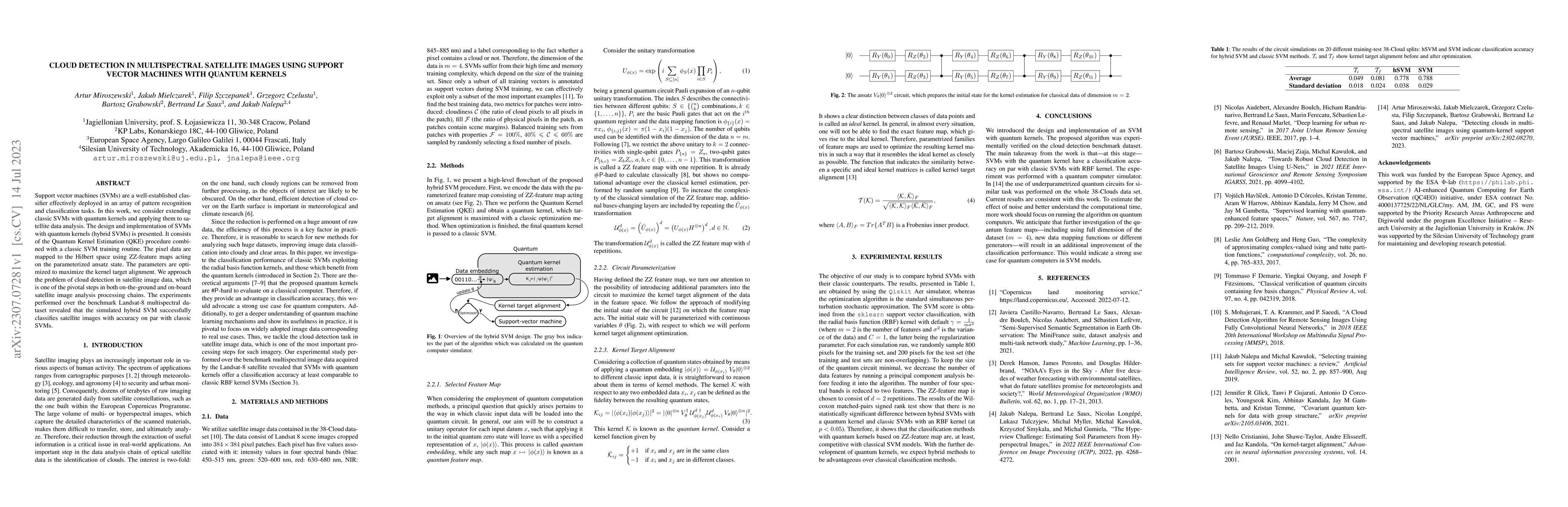
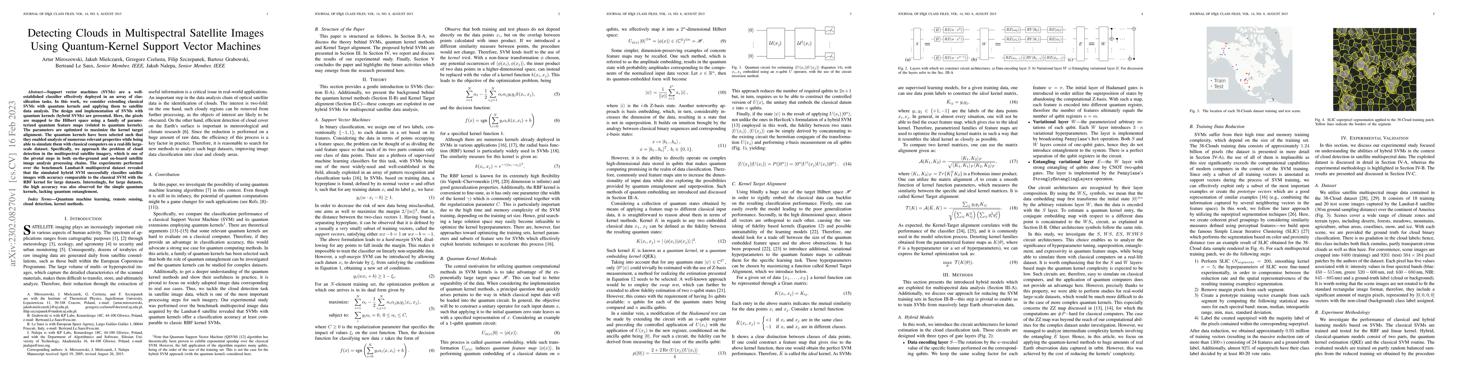
Support vector machines (SVMs) are a well-established classifier effectively deployed in an array of pattern recognition and classification tasks. In this work, we consider extending classic SVMs wi...
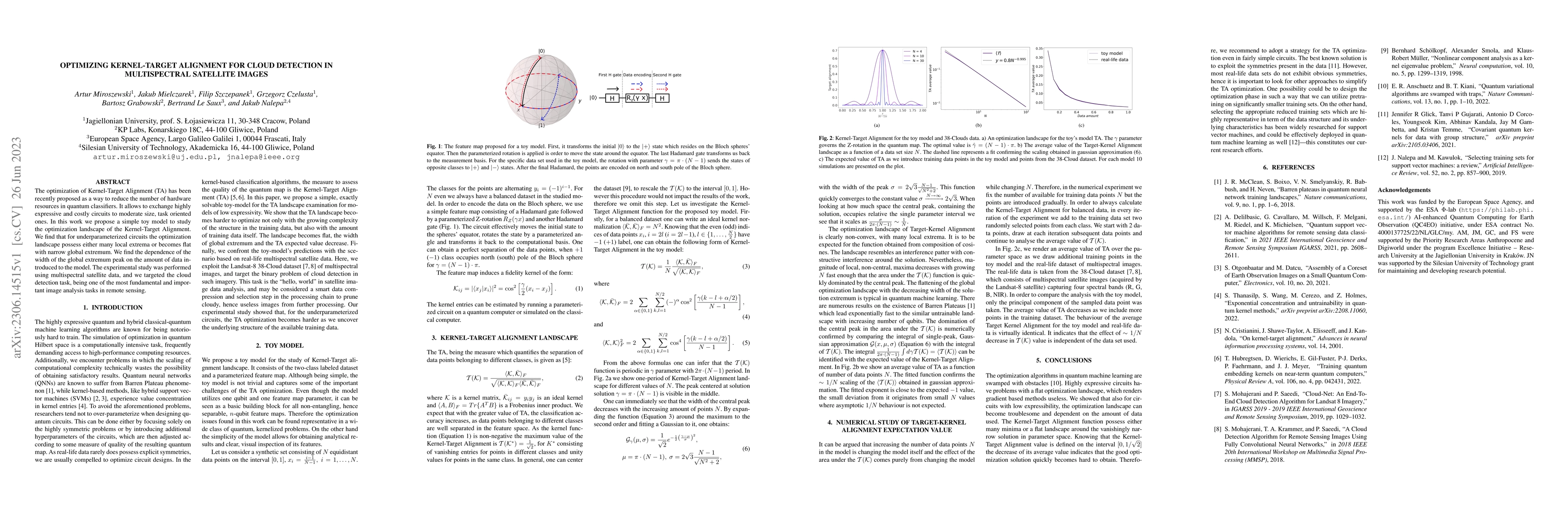
The optimization of Kernel-Target Alignment (TA) has been recently proposed as a way to reduce the number of hardware resources in quantum classifiers. It allows to exchange highly expressive and co...
Cloud detection is a pivotal satellite image pre-processing step that can be performed both on the ground and on board a satellite to tag useful images. In the latter case, it can reduce the amount ...
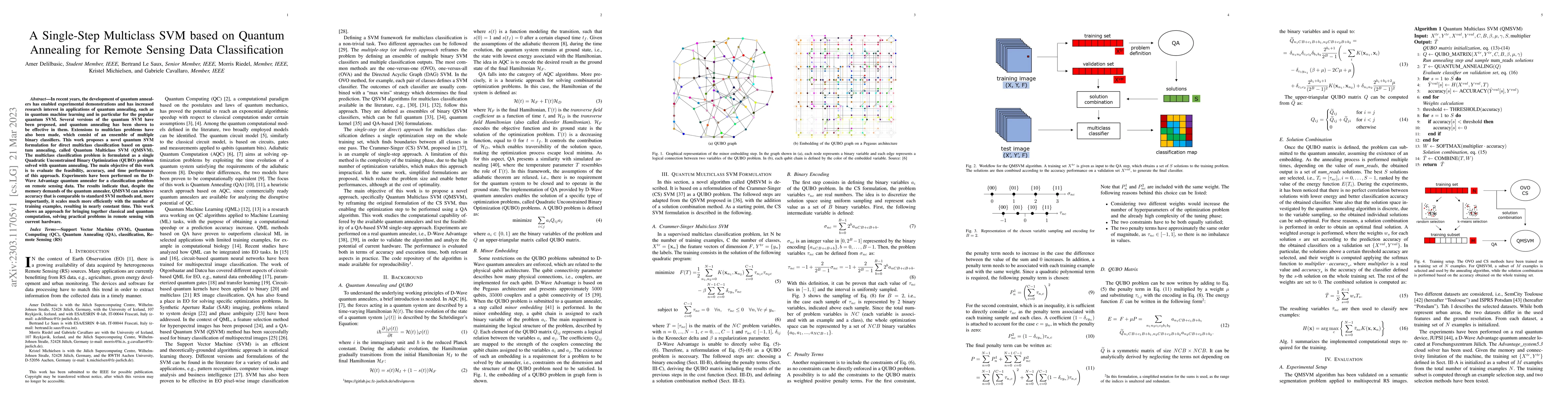
In recent years, the development of quantum annealers has enabled experimental demonstrations and has increased research interest in applications of quantum annealing, such as in quantum machine lea...
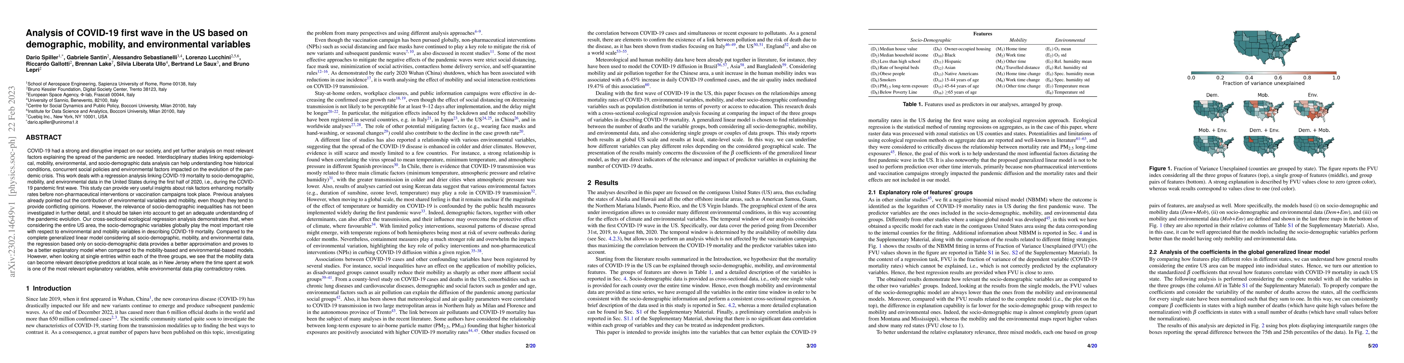
COVID-19 had a strong and disruptive impact on our society, and yet further analyses on most relevant factors explaining the spread of the pandemic are needed. Interdisciplinary studies linking epid...
Support vector machines (SVMs) are a well-established classifier effectively deployed in an array of classification tasks. In this work, we consider extending classical SVMs with quantum kernels and...
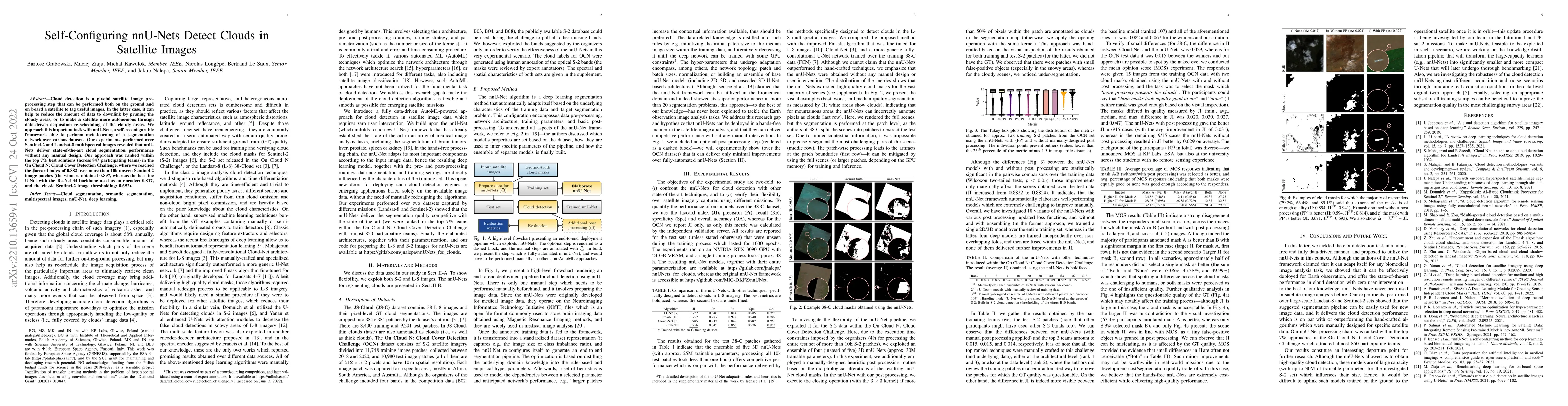
Cloud detection is a pivotal satellite image pre-processing step that can be performed both on the ground and on board a satellite to tag useful images. In the latter case, it can help to reduce the...
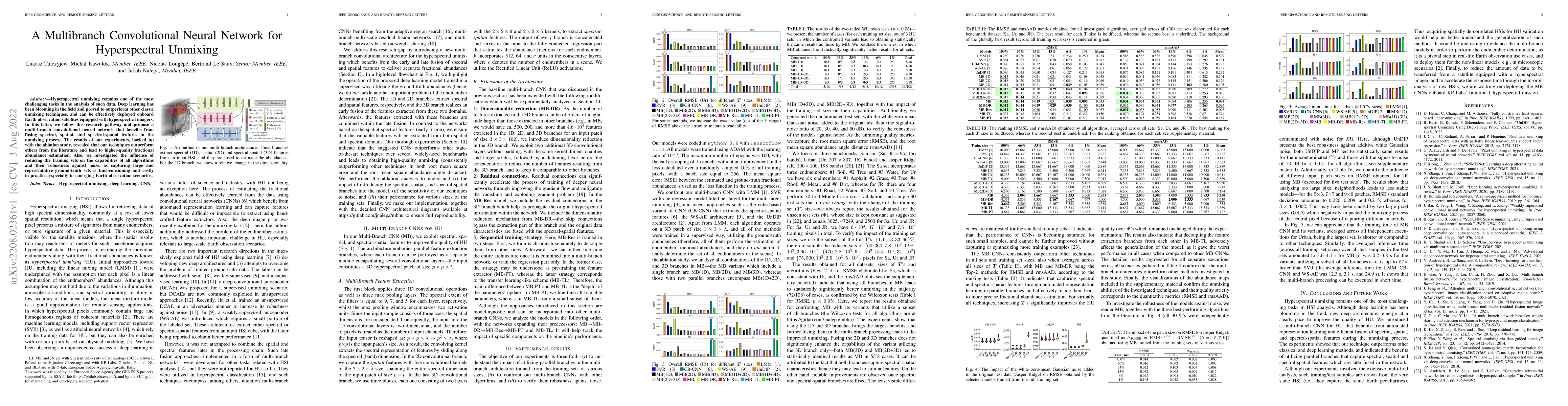
Hyperspectral unmixing remains one of the most challenging tasks in the analysis of such data. Deep learning has been blooming in the field and proved to outperform other classic unmixing techniques...
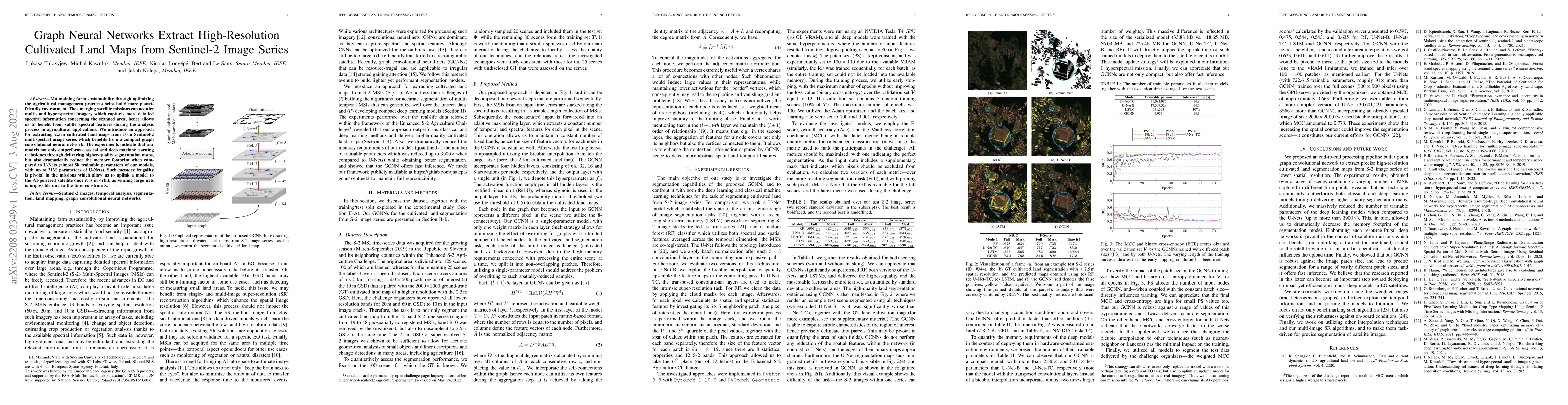
Maintaining farm sustainability through optimizing the agricultural management practices helps build more planet-friendly environment. The emerging satellite missions can acquire multi- and hyperspe...
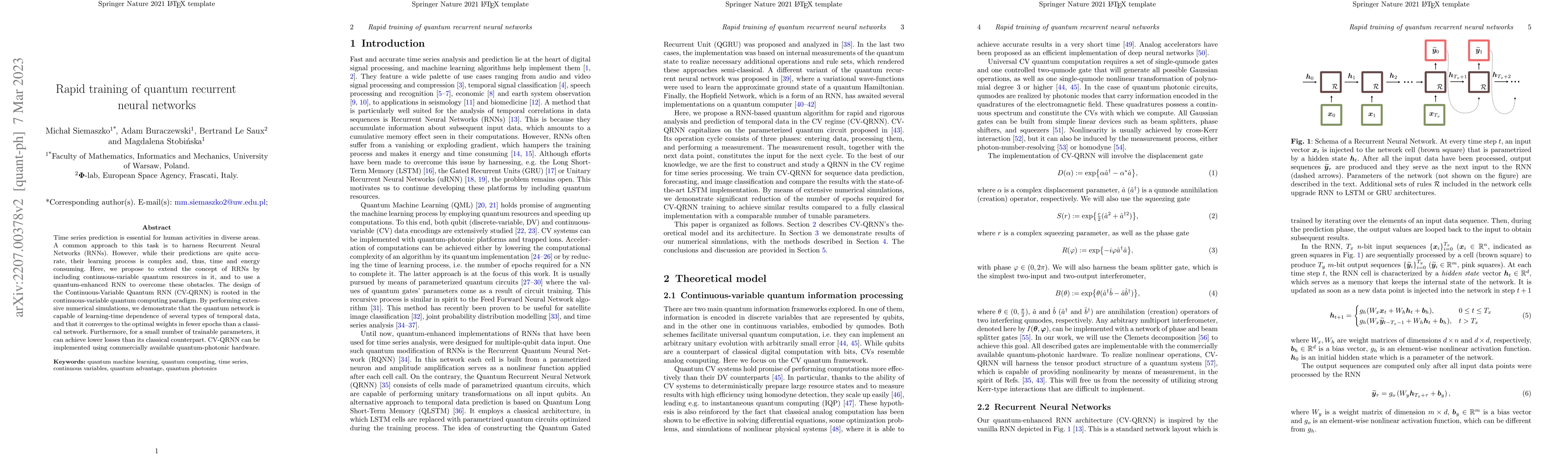
Time series prediction is essential for human activities in diverse areas. A common approach to this task is to harness Recurrent Neural Networks (RNNs). However, while their predictions are quite a...
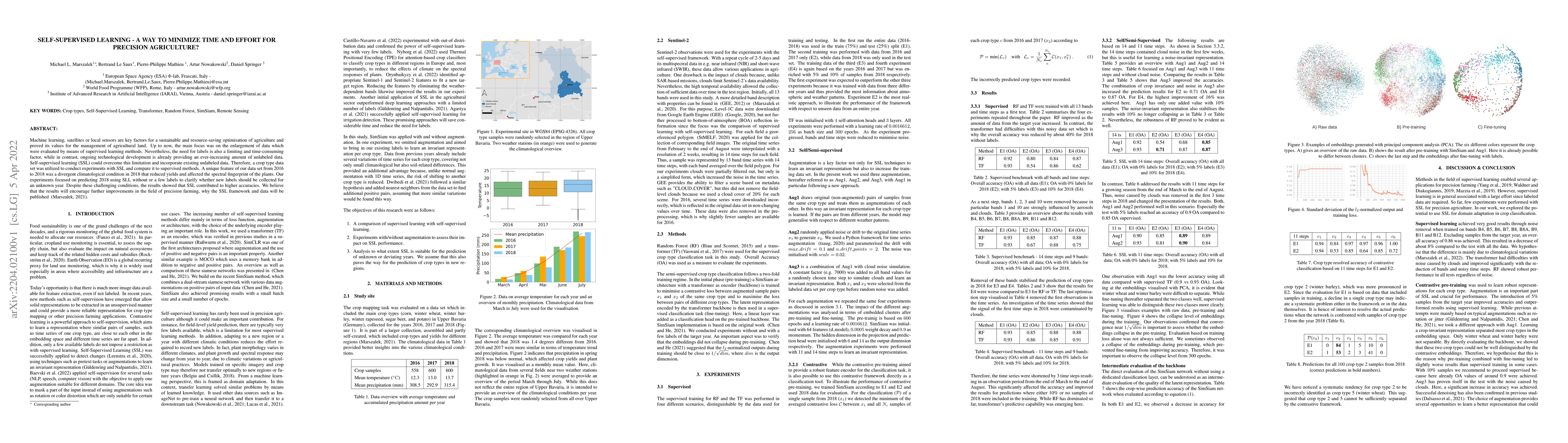
Machine learning, satellites or local sensors are key factors for a sustainable and resource-saving optimisation of agriculture and proved its values for the management of agricultural land. Up to n...
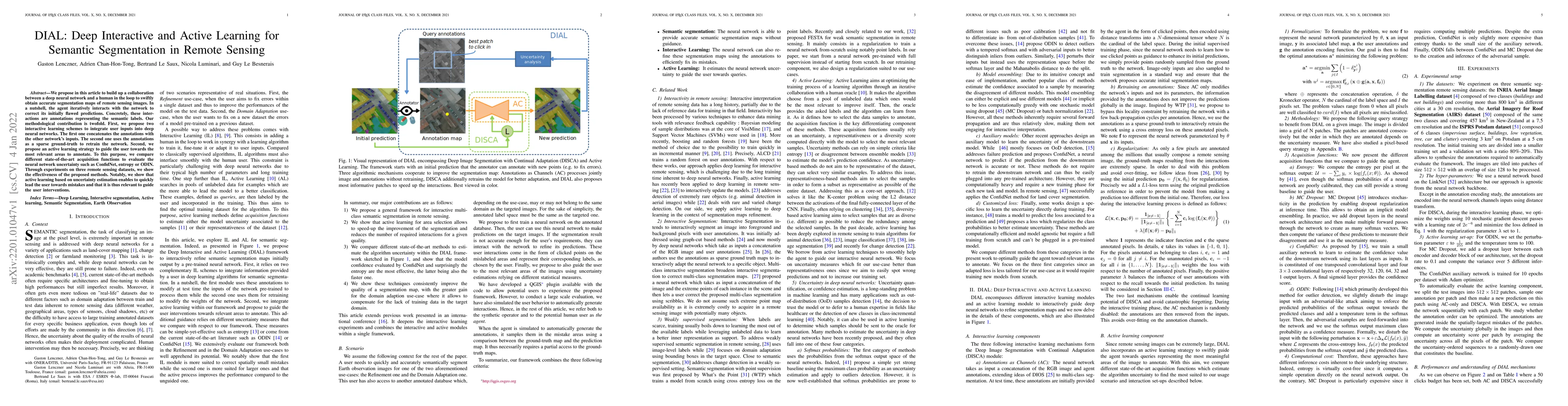
We propose in this article to build up a collaboration between a deep neural network and a human in the loop to swiftly obtain accurate segmentation maps of remote sensing images. In a nutshell, the...
Transfer learning is a powerful way to adapt existing deep learning models to new emerging use-cases in remote sensing. Starting from a neural network already trained for semantic segmentation, we p...
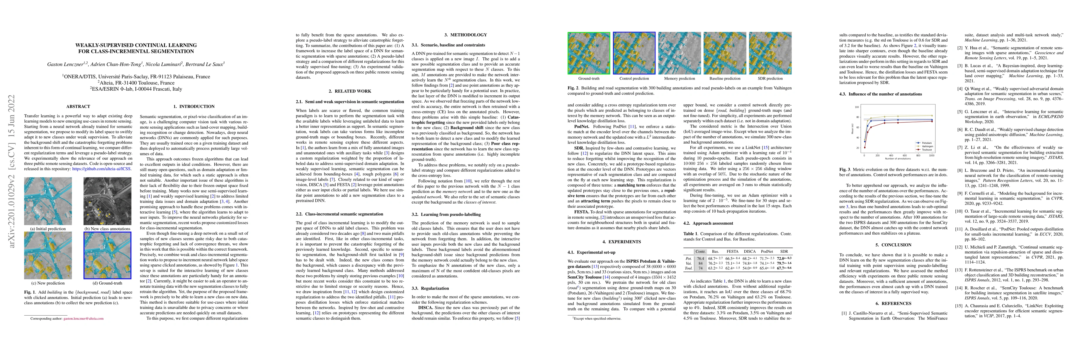
Large scale datasets created from crowdsourced labels or openly available data have become crucial to provide training data for large scale learning algorithms. While these datasets are easier to ac...
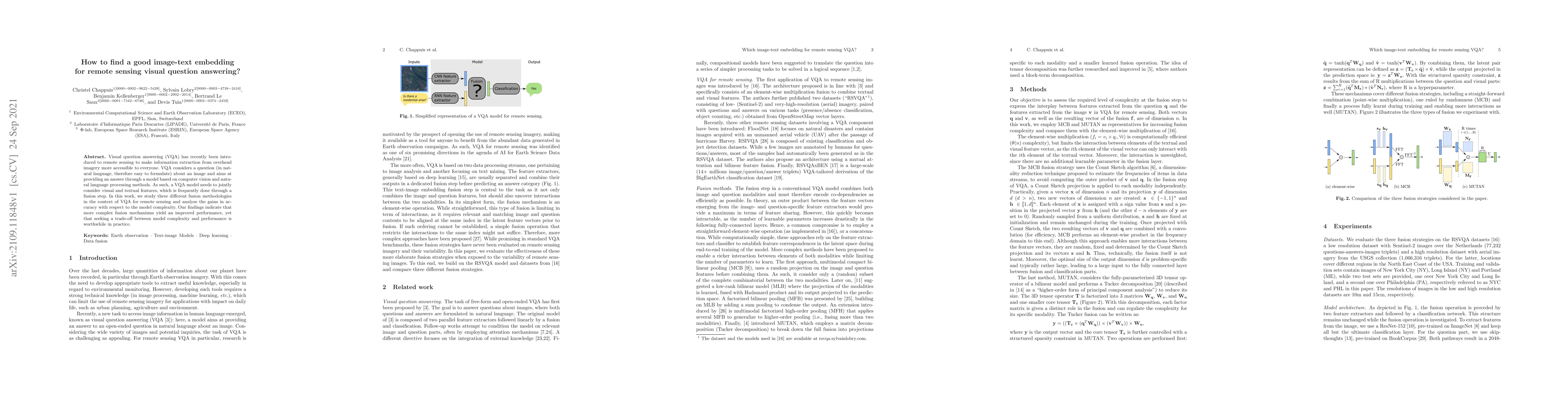
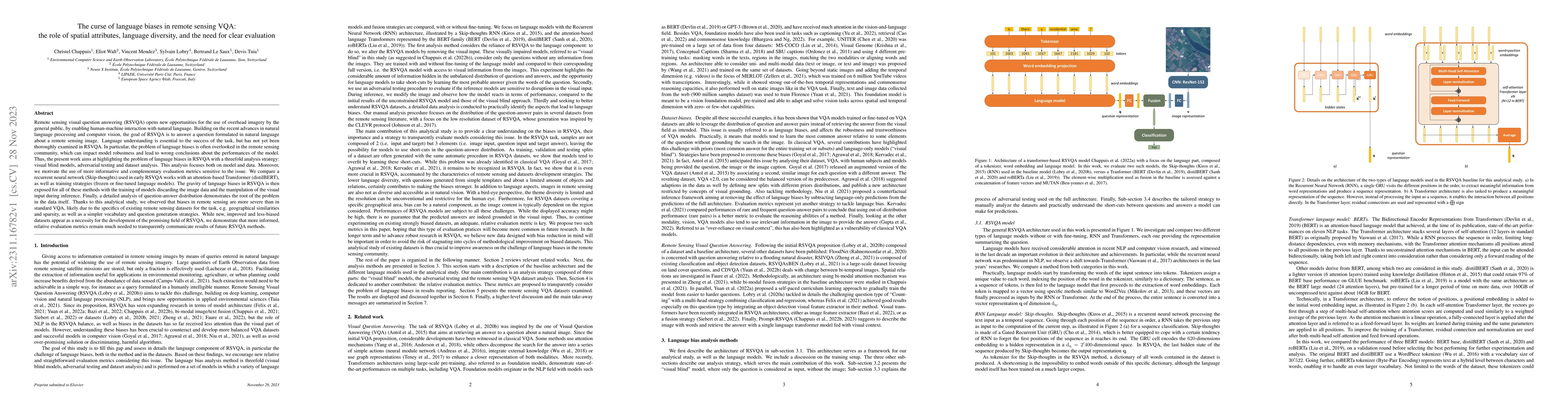
Visual question answering (VQA) has recently been introduced to remote sensing to make information extraction from overhead imagery more accessible to everyone. VQA considers a question (in natural ...
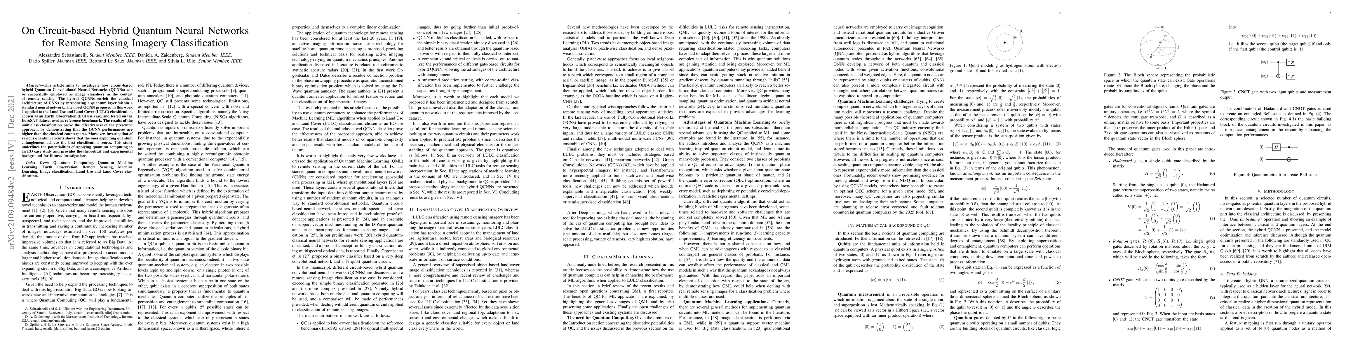
This article aims to investigate how circuit-based hybrid Quantum Convolutional Neural Networks (QCNNs) can be successfully employed as image classifiers in the context of remote sensing. The hybrid...
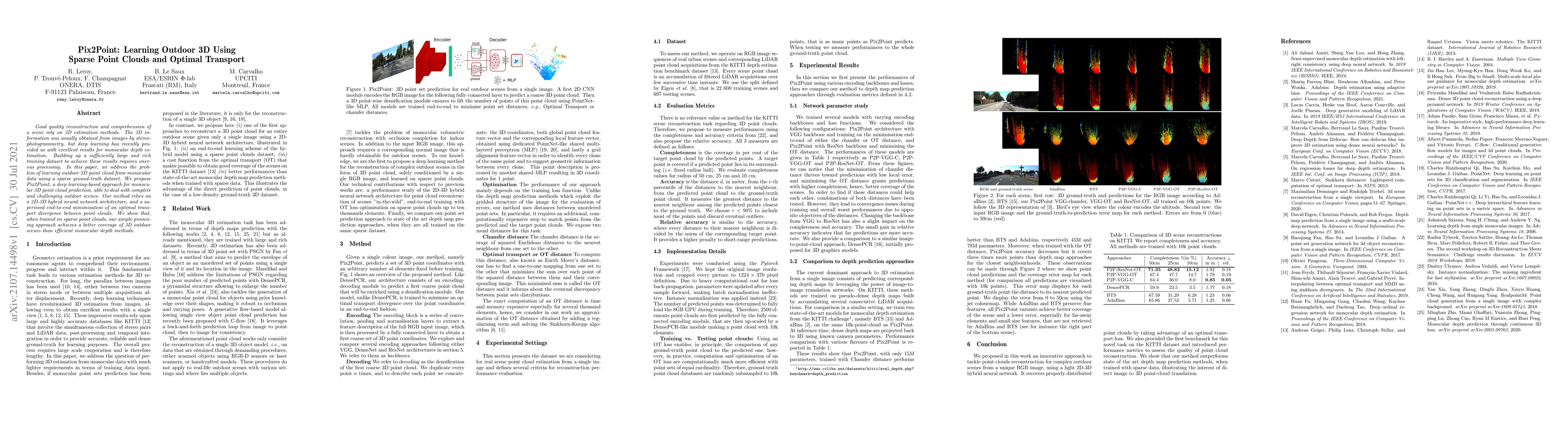
Good quality reconstruction and comprehension of a scene rely on 3D estimation methods. The 3D information was usually obtained from images by stereo-photogrammetry, but deep learning has recently p...
To address the mounting destruction caused by floods in climate-vulnerable regions, we propose Street to Cloud, a machine learning pipeline for incorporating crowdsourced ground truth data into the ...
The development of semi-supervised learning techniques is essential to enhance the generalization capacities of machine learning algorithms. Indeed, raw image data are abundant while labels are scar...
Dense pixel-wise classification maps output by deep neural networks are of extreme importance for scene understanding. However, these maps are often partially inaccurate due to a variety of possible...
This paper presents an interactive approach for multi-class segmentation of aerial images. Precisely, it is based on a deep neural network which exploits both RGB images and annotations. Starting fr...
Aerial or satellite imagery is a great source for land surface analysis, which might yield land use maps or elevation models. In this investigation, we present a neural network framework for learnin...
This paper is a technical report about our submission for the ECCV 2018 3DRMS Workshop Challenge on Semantic 3D Reconstruction \cite{Tylecek2018rms}. In this paper, we address 3D semantic reconstruc...
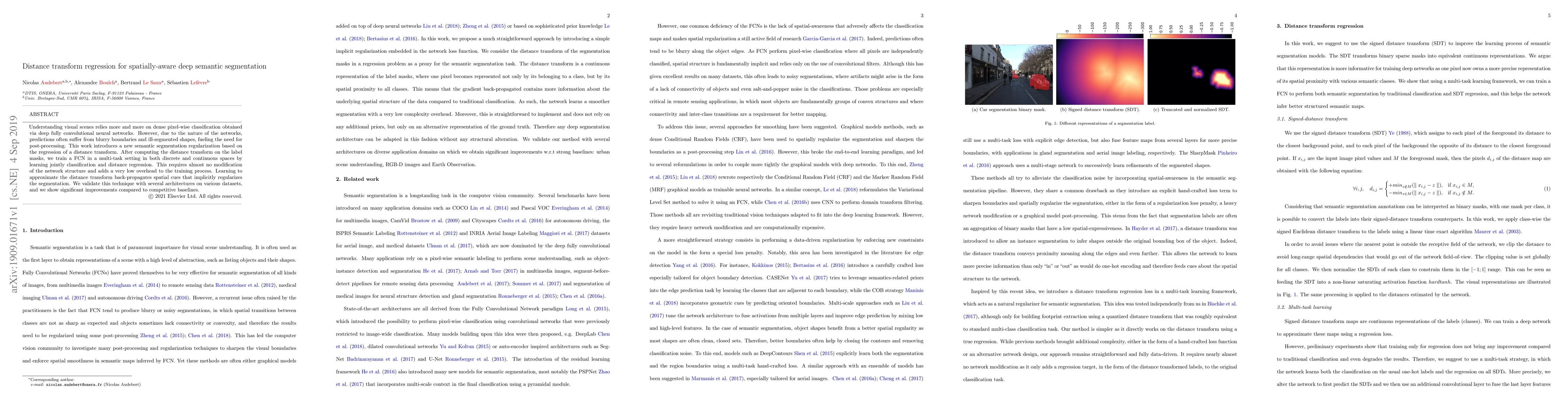
Understanding visual scenes relies more and more on dense pixel-wise classification obtained via deep fully convolutional neural networks. However, due to the nature of the networks, predictions oft...
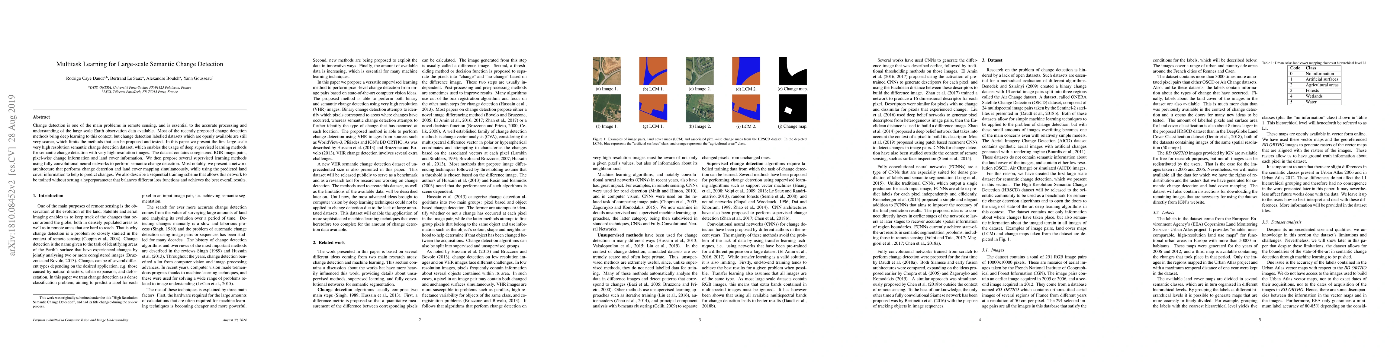
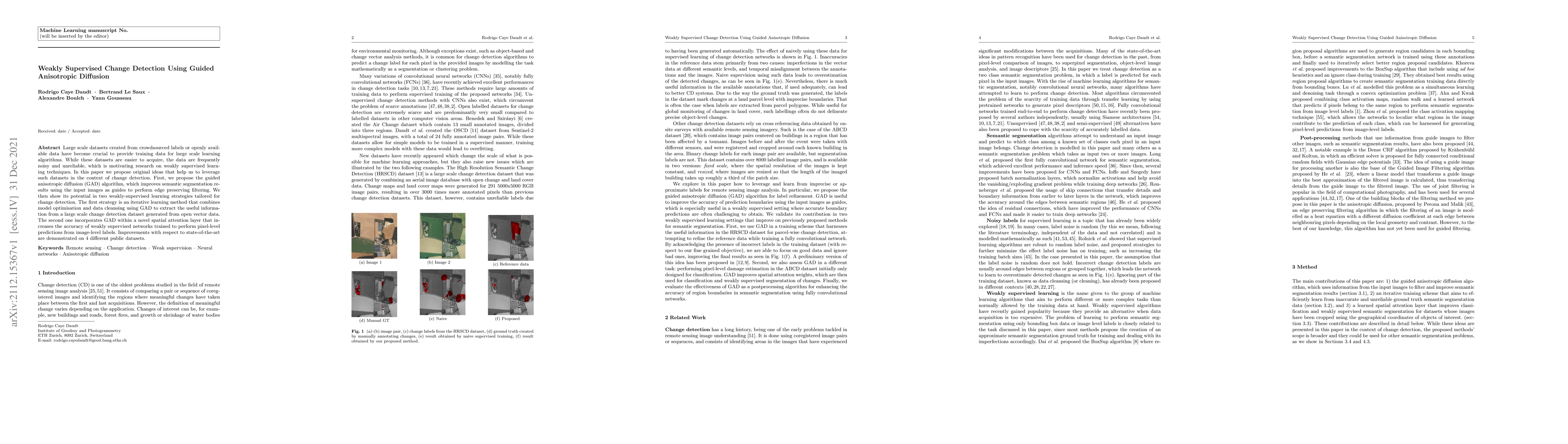
Change detection is one of the main problems in remote sensing, and is essential to the accurate processing and understanding of the large scale Earth observation data available through programs suc...
Quantum Machine Learning (QML) has gathered significant attention through approaches like Quantum Kernel Machines. While these methods hold considerable promise, their quantum nature presents inherent...
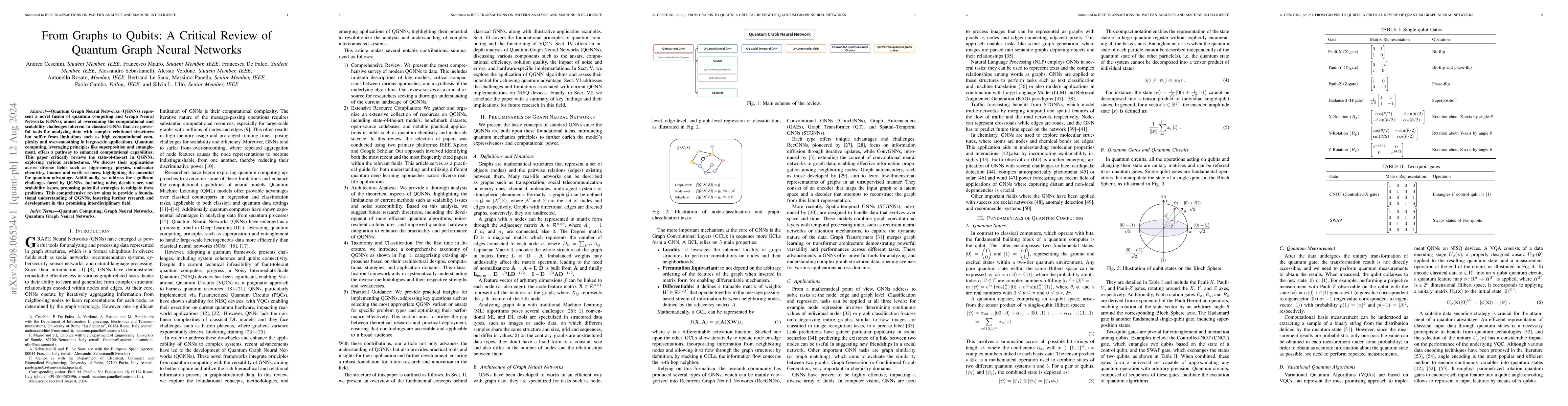
Quantum Graph Neural Networks (QGNNs) represent a novel fusion of quantum computing and Graph Neural Networks (GNNs), aimed at overcoming the computational and scalability challenges inherent in class...
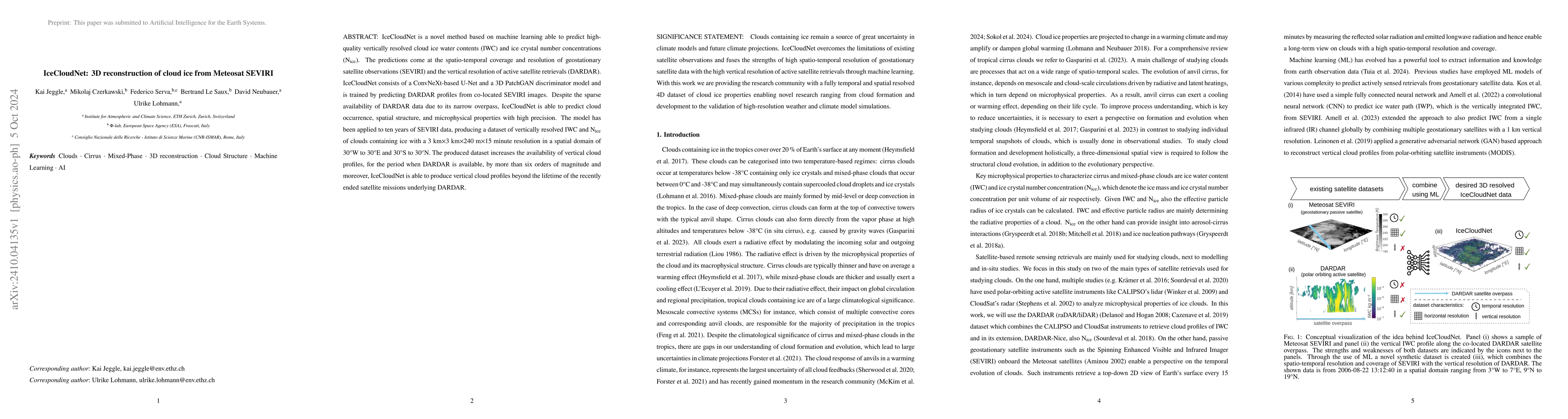
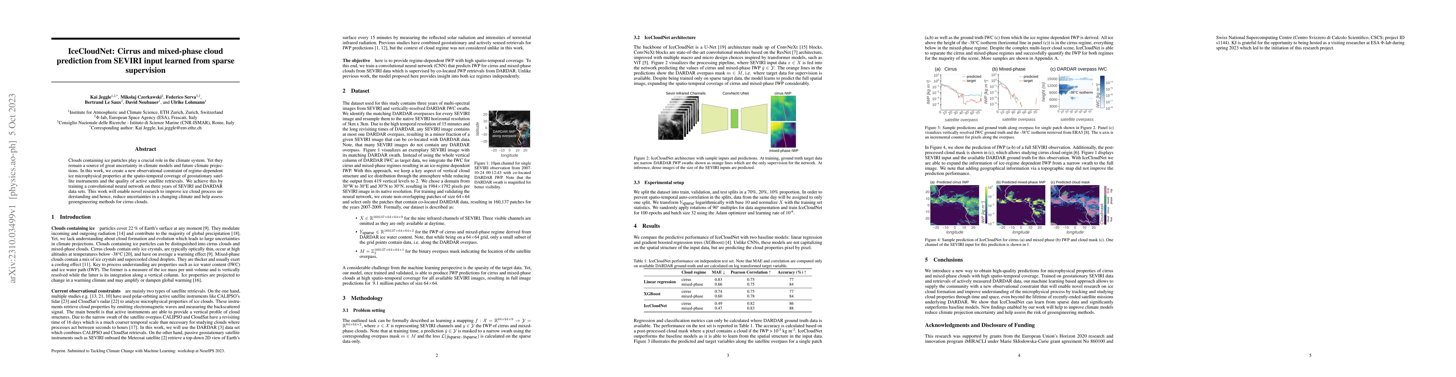
IceCloudNet is a novel method based on machine learning able to predict high-quality vertically resolved cloud ice water contents (IWC) and ice crystal number concentrations (N$_\textrm{ice}$). The pr...
A significant amount of remotely sensed data is generated daily by many Earth observation (EO) spaceborne and airborne sensors over different countries of our planet. Different applications use those ...
The introduction of quantum concepts is increasingly making its way into generative machine learning models. However, while there are various implementations of quantum Generative Adversarial Networks...
Today, Earth Observation (EO) satellites generate massive volumes of data, with the Copernicus Sentinel-2 constellation alone producing approximately 1.6TB per day. To fully exploit this information, ...
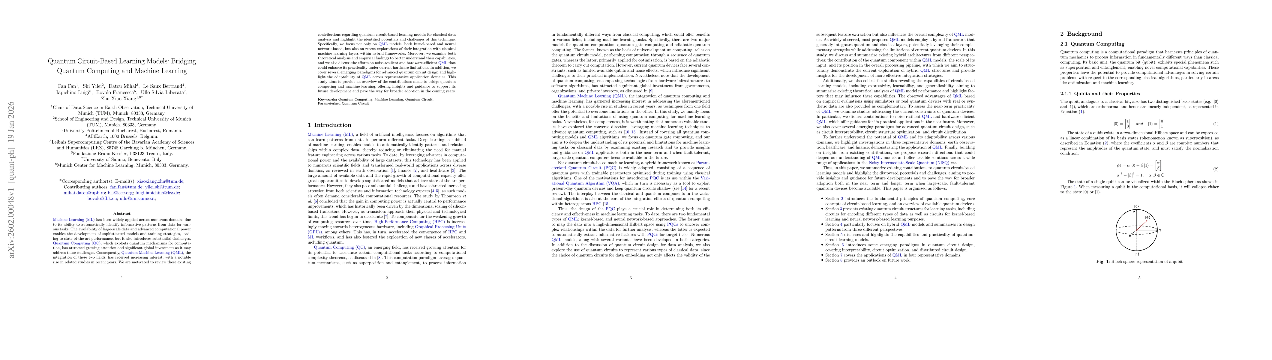
Machine Learning (ML) has been widely applied across numerous domains due to its ability to automatically identify informative patterns from data for various tasks. The availability of large-scale dat...