Learning from Unlabelled Data with Transformers: Domain Adaptation for Semantic Segmentation of High Resolution Aerial Images
Publication
Metrics
AI Quick Summary
The paper introduces the NEOS model for semantic segmentation of unlabelled high-resolution aerial images, utilizing domain adaptation to bridge distributional gaps between source and target domains, achieving superior performance compared to existing methods.
Paper Preview
Abstract
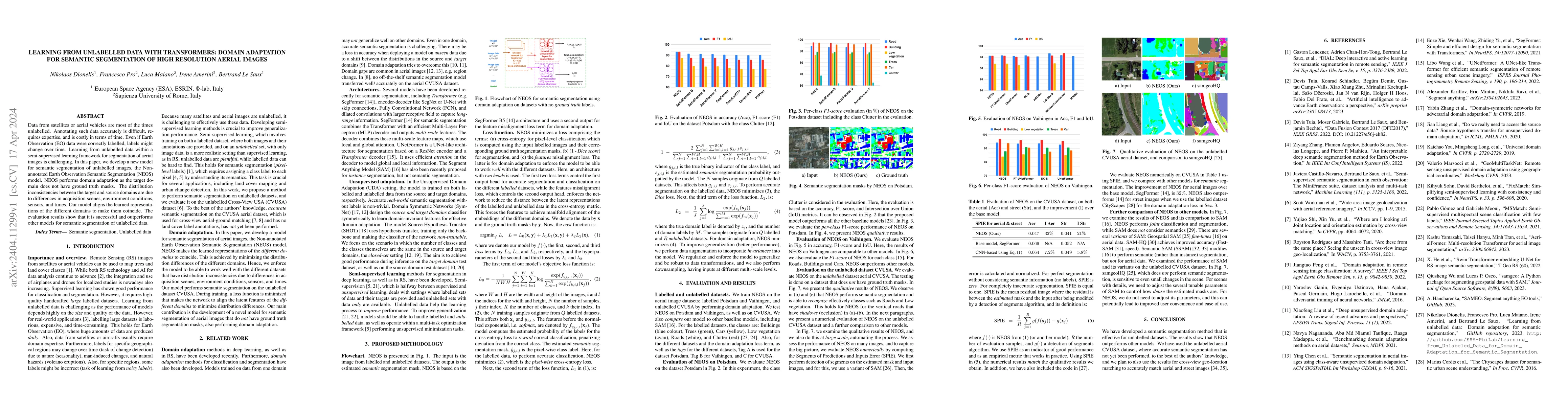
Data from satellites or aerial vehicles are most of the times unlabelled. Annotating such data accurately is difficult, requires expertise, and is costly in terms of time. Even if Earth Observation (EO) data were correctly labelled, labels might change over time. Learning from unlabelled data within a semi-supervised learning framework for segmentation of aerial images is challenging. In this paper, we develop a new model for semantic segmentation of unlabelled images, the Non-annotated Earth Observation Semantic Segmentation (NEOS) model. NEOS performs domain adaptation as the target domain does not have ground truth semantic segmentation masks. The distribution inconsistencies between the target and source domains are due to differences in acquisition scenes, environment conditions, sensors, and times. Our model aligns the learned representations of the different domains to make them coincide. The evaluation results show that NEOS is successful and outperforms other models for semantic segmentation of unlabelled data.
AI Key Findings
Get AI-generated insights about this paper's methodology, results, significance, and more — seven facets brought into focus.
Impact
Paper Details
Authors
PDF Preview
Key Terms
Citation Network
Current paper (gray), citations (green), references (blue)
Display is limited for performance on very large graphs.
Discussion 0