Quick Summary:

This research paper explores how virtual globes can be enhanced to support spatial thinking by enabling users to ask "why" questions about spatial distributions, beyond the current limited scope of "what is where." The study proposes a multi-touch virtual globe designed to facilitate simple "why" inquiries, aiming to broaden the technology's appeal and utility without full GIS functionality.

Summary

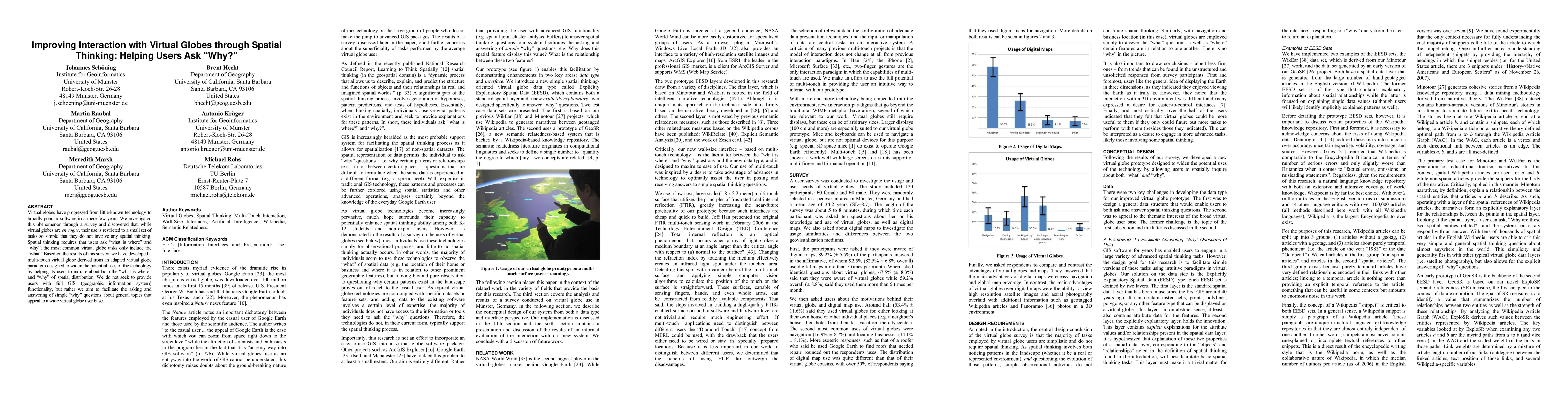
Virtual globes have progressed from little-known technology to broadly popular software in a mere few years. We investigated this phenomenon through a survey and discovered that, while virtual globes are en vogue, their use is restricted to a small set of tasks so simple that they do not involve any spatial thinking. Spatial thinking requires that users ask "what is where" and "why"; the most common virtual globe tasks only include the "what". Based on the results of this survey, we have developed a multi-touch virtual globe derived from an adapted virtual globe paradigm designed to widen the potential uses of the technology by helping its users to inquire about both the "what is where" and "why" of spatial distribution. We do not seek to provide users with full GIS (geographic information system) functionality, but rather we aim to facilitate the asking and answering of simple "why" questions about general topics that appeal to a wide virtual globe user base.

AI Key Findings

Get AI-generated insights about this paper's methodology, results, and significance.

Paper Details

PDF Preview

Download PDF

Key Terms

virtual (0.412)
virtual (0.408)
users (0.263)
users (0.262)
spatial (0.224)
spatial (0.222)
technology (0.216)
technology (0.215)
survey (0.198)
survey (0.196)
tasks (0.179)
en (0.177)
tasks (0.177)
en (0.169)
spatial distribution (0.169)
answering (0.168)
seek (0.162)
answering (0.161)
topics (0.158)
topics (0.156)

Citation Network

Current paper (gray), citations (green), references (blue)

Current Paper
Citations
References
Click to view
Title Authors Year Actions
Google Earth-aided visualization and interpretation of geochemical survey data
R. Zuo, Bojun Yin
2022
View Paper
The Effect of Google Earth-Assisted Remote Sensing Learning on Students ’Spatial Thinking Ability in Solving Disaster Mitigation Problems
B. Hadi, Mukminan, Muhsinatun Siasah, K. E. Sariyono
2021
View Paper
Utilizing Game Engine for Development Interactive 3-Dimensional Geographic Information System (GIS) Agriculture Commodity Selection and Land Evaluation
Hanhan Maulana, H. Kanai
2021
View Paper
Geographic information science III
Stéphane Roche
2017
View Paper
User studies in cartography: opportunities for empirical research on interactive maps and visualizations
R. Roth, A. Çöltekin, L. Delazari, H. F. Filho, A. Griffin, Andreas Hall, J. Korpi, Ismini-Eleni Lokka, André Mendonça, Kristien Ooms, C. V. van Elzakker
2017
View Paper
Spatiotemporal correlation in WebGIS group-user intensive access patterns
Rui Li, Jiapei Fan, Jie Jiang, Huayi Wu
2017
View Paper
Mobile 3D visualization techniques in field geology education
L. Hama
2016
View Paper
Naive (commonsense) geography and geobrowser usability after ten years of Google Earth
J. Hamerlinck
2016
View Paper
Improving Interactions with Spatial Context-aware Services
P. A. Samsonov
2016
View Paper
Interaction with geospatial data
Johannes Schöning
2015
View Paper
Turkers, Scholars, "Arafat" and "Peace": Cultural Communities and Algorithmic Gold Standards
Shilad Sen, Margaret E. Giesel, Rebecca Gold, Benjamin Hillmann, Matt Lesicko, Samuel Naden, Jesse Russell, Zixiao Wang, Brent J. Hecht
2015
View Paper
Informing online and mobile map design with the collective wisdom of cartographers
Johannes Schöning, Brent J. Hecht, W. Kuhn
2014
View Paper
Developing a Framework for Describing and Comparing Indoor Maps
A. Nossum
2013
View Paper
Design of a Visual Query Language for Geographic Information System on a Touch Screen
Siju Wu, S. Otmane, G. Moreau, M. Servieres
2013
View Paper
Geographic human-computer interaction
Brent J. Hecht, Johannes Schöning, Thomas Erickson, R. Priedhorsky
2013
View Paper
How users interact with a 3D geo-browser under time pressure
J. Wilkening, S. Fabrikant
2013
View Paper
TouchPosing: multi-modal interaction with geospatial data
Florian Daiber, Sven Gehring, Markus Löchtefeld, A. Krüger
2012
View Paper
Perception and reality: exploring urban planners' vision on GIS tasks for multi-touch displays
Rojin S. Vishkaie, R. Levy
2012
View Paper
Collaborative Map Exploration Using Multitouch Surfaces
P. Villanueva, R. Tesoriero, M. Lozano
2012
View Paper
TangiWheel: A Widget for Manipulating Collections on Tabletop Displays Supporting Hybrid Input Modality
A. Catalá, Fernando Garcia-Sanjuan, J. Martínez, José A. Mocholí
2012
View Paper
Google Earth as a virtual globe tool for Earth science applications at the global scale: progress and perspectives
Le Yu, P. Gong
2012
View Paper
Evaluating the Effectiveness of Thematic Mapping on Virtual Globes
T. White
2012
View Paper
Using Web‐Based GIS and Virtual Globes in Undergraduate Education
Lynn C. Songer
2012
View Paper
Interaction Design for Multi-touch Interactive Walls
Wang Chen, Lao Song-yang, Hyowon Lee, A. Smeaton
2012
View Paper
Google Earth and Google Fusion Tables in support of time-critical collaboration: Mapping the deepwater horizon oil spill with the AVIRIS airborne spectrometer
E. Bradley, D. Roberts, P. Dennison, R. Green, M. Eastwood, S. Lundeen, I. McCubbin, I. Leifer
2011
View Paper
Usability Testing of the Interaction of Novices with a Multi-touch Table in Semi Public Space
M. Jokisch, T. Bartoschek, A. Schwering
2011
View Paper
GeoGlobe: A Virtual Globe for multi-source geospatial information integration and service
J. Gong, Longgang Xiang, Jin Chen, P. Yue, Yi Liu
2011
View Paper
Geographic human-computer interaction
Brent J. Hecht, Johannes Schöning, Thomas Erickson, Reid Priedhorsky
2011
View Paper
A multi-touch enabled human-transporter metaphor for virtual 3D traveling
Dimitar Valkov, Frank Steinicke, G. Bruder, K. Hinrichs
2010
View Paper
Cartography Meets Gaming: Navigating Globes, Block Diagrams and 2D Maps with Gamepads and Joysticks
Adrian Weber, B. Jenny, Matthias Wanner, J. Cron, Philipp Marty, L. Hurni
2010
View Paper
Analysis of natural gestures for controlling robot teams on multi-touch tabletop surfaces
M. Micire, Munjal Desai, Amanda Courtemanche, K. Tsui, H. Yanco
2009
View Paper
Sharetouch: a multi-touch social platform for the elderly
Hsien-Tsung Chang
2009
View Paper
Bimanual Interaction with Interscopic Multi-Touch Surfaces
Johannes Schöning, Frank Steinicke, A. Krüger, K. Hinrichs, Dimitar Valkov
2009
View Paper
Whole Body Interaction with Geospatial Data
Florian Daiber, Johannes Schöning, A. Krüger
2009
View Paper
Using hands and feet to navigate and manipulate spatial data
Johannes Schöning, Florian Daiber, A. Krüger, Michael Rohs
2009
View Paper
Poster: Interscopic multi-touch surfaces: Using bimanual interaction for intuitive manipulation of spatial data
Johannes Schöning, Frank Steinicke, A. Krüger, K. Hinrichs
2009
View Paper
Building Interactive Multi-Touch Surfaces
Johannes Schöning, Jonathan Hook, Tom Bartindale, Dominik Schmidt, P. Olivier, Florian Echtler, Nima Motamedi, P. Brandl, Ulrich von Zadow
2009
View Paper
Image geo-mashups: the example of an augmented reality weather camera
Jana Gliet, A. Krüger, O. Klemm, Johannes Schöning
2008
View Paper
Determining geographic representations for arbitrary concepts at query time
A. Henrich, Volker Lüdecke
2008
View Paper
Evaluating automatically generated location-based stories for tourists
Johannes Schöning, Brent J. Hecht, Nicole Starosielski
2008
View Paper
A Critical Study of Geospatial Algorithm Use in Crime Analysis and Predictive Policing
Katherine Weathington
2020
View Paper
Design and Evaluation of a Visualization Method in a GIS for Complex Electronic Warfare Assessment with Regards to Usability
Susanne Dahlgren
2019
View Paper
Increasing usability and accessibility of GIS technology through extension of existing software tools
Elizabeth Joan Noel
2015
View Paper
Geovisualization and time based mission planning on a multi-touch tabletop
Robert W. M. Boensma
2015
View Paper
Visualising the industrial north : exploring new ways to engage and inform the public on the physical footprint and scale of very large resource extraction projects such as the Alberta tar sands open pit mines and associated pipelines
P. Čížek
2014
View Paper
Interaktion mit räumlichen Daten Interaction with geospatial data
2014
View Paper
Analysis of the Spatial Thinking of College Students in Traditional and Web-facilitated Introductory Geography Courses using Aerial Photography and Geo-visualization Technology
R. Palmer
2014
View Paper
EXPLORING NEW VISUALIZATION METHODS FOR MULTI-STOREY INDOOR ENVIRONMENTS AND DYNAMIC SPATIAL PHENOMENA
A. Nossum
2013
View Paper
The Potential of Using Web Mapping as a Tool to Support Cultural History Investigations
David Schobesberger, W. Cartwright
2013
View Paper
The mining and application of diverse cultural perspectives in user-generated content
Darren Gergle, Brent J. Hecht
2013
View Paper
Context-Sensitive Display Environments
Florian Daiber, A. Krüger, Johannes Schöning, Jörg Müller
2012
View Paper
Towards a framework for improving the usability of web-mapping products
David Schobesberger
2012
View Paper
Earth as a virtual globe tool for Earth science applications at the global scale : progress and perspectives
Le Yu, P. Gong
2012
View Paper
DESIGNING AND ASSESSING A MULTI-USER TABLETOP INTERFACE TO SUPPORT COLLABORATIVE DECISION-MAKING INVOLVING DYNAMIC GEOSPATIAL DATA
Stacey, D., Scott, A. Allavena, K. Cerar, P. McClelland, Victor Cheung
2011
View Paper
Executive summary Investigation of a Prototype Naval Planning Tool for Tabletop Computing Research : Final Report
Stacey D. Scott, A. Allavena
2011
View Paper
International Conference : Spatial Thinking and Geographic Information Sciences 2011 An Approach to Modeling Spatial Perception for Geovisualization
Kenan, A. Çöltekina
2011
View Paper
Towards a Framework for Whole Body Interaction with Geospatial Data
Florian Daiber, Johannes Schöning, A. Krüger
2011
View Paper
Un cadre de conception pour la Visualisation d'Information Interactive. (A framework for Interactive Information Visualization)
Romain Vuillemot
2010
View Paper
Investigating Tabletop Interfaces to Support Collaborative Decision-Making in Maritime Operations
Stacey D. Scott, A. Allavena, K. Cerar, G. Franck, M. Hazen, T. Shuter, C. Colliver
2010
View Paper
Traveling in 3 D Virtual Environments with Foot Gestures and a Multi-Touch enabled
Valkov
2010
View Paper
Touching the future: the rise of multitouch interfaces
J. Schoening
2010
View Paper
Advanced Natural and Tangible Interfaces for Spatial Information
2009
View Paper
Do we need further “ multi-touch ” touch affordances ?
Johannes Schöning
2009
View Paper
BAD GLOBES & BETTER GLOBES – MULTILINGUAL CATEGORIZATION OF CARTOGRAPHIC CONCEPTS EXEMPLIFIED BY “MAP” AND “GLOBE” IN ENGLISH, GERMAN AND SPANISH
F. Hruby
2009
View Paper
Advanced user interfaces for spatial information
Johannes Schöning
2009
View Paper
Multi-Touch-und Multi-User-Interaktion zur Verbesserung des kollaborativen Arbeitens in Katastrophenstäben
C. Stasch, Florian Daiber, Ac Walkowski, J. Schoening, A. Krüger
2009
View Paper
Progetti e strumenti a supporto della Geografia e della Cartografia: la "terra digitale" ed i mappamondi virtuali
A. Favretto
2009
View Paper
Mapping the Zeitgeist
Brent J. Hecht, Johannes Schöning
2008
View Paper
PPD 2008: Workshop on designing multi-touch interaction techniques for coupled public and private displays
S. Izadi, S. Subramanian
2008
View Paper
Multi – Touching 3 D Data : Towards Direct Interaction in Stereoscopic Display Environments coupled with Mobile Devices
Frank Steinicke, K. Hinrichs, Johannes Schöning
2008
View Paper
Multi-Modal Navigation through Spatial Information
J. Schoening, A. Krüger
2008
View Paper
Ad Hoc Determination of Geographic Regions for Concept@Location Queries
A. Henrich, Volker Lüdecke
2008
View Paper
Multi-Touch Surfaces: A Technical Guide Technical Report TUM-I0833
Johannes Schöning, P. Brandl, Florian Daiber, Florian Echtler, Otmar Hilliges, Jonathan Hook, Markus Löchtefeld, Nima Motamedi, L. Muller, P. Olivier, Tim Roth, Ulrich von Zadow
2007
View Paper

Comments (0)

This website uses cookies to ensure you get the best experience. Learn more