Quick Answers
What methodology did the authors use?
Modular incremental RGB+LiDAR pipeline using FAST‑LIO2 odometry, OneFormer panoptic segmentation, label‑aware TSDF fusion with dynamic, class‑conditioned truncation, and per‑voxel semantic/geometric uncertainty estimation. More in Methodology →
What are the key results?
Semantic guidance reduces reconstruction error to 14.54cm RMSE and increases completeness to 98.55% and F1 to 98.58%, outperforming ImMesh and Voxblox. — Qualitative evaluation on Oxford Spires and NTU VIRAL demonstrates robust reconstruction of thin structures and high‑frequency details in complex indoor/outdoor scenes. More in Key Results →
Why is this work significant?
Provides a practical path from LiDAR‑inertial scanning to USD‑compatible, semantically labeled meshes for XR and digital heritage modeling, improving fidelity in sparse, drift‑prone environments. More in Significance →
What are the main limitations?
Odometry drift accumulates over long trajectories, limiting long‑term accuracy. — Performance depends on camera field‑of‑view, calibration quality, and segmentation accuracy; thin, specular, or cluttered scenes remain challenging. More in Limitations →
Abstract
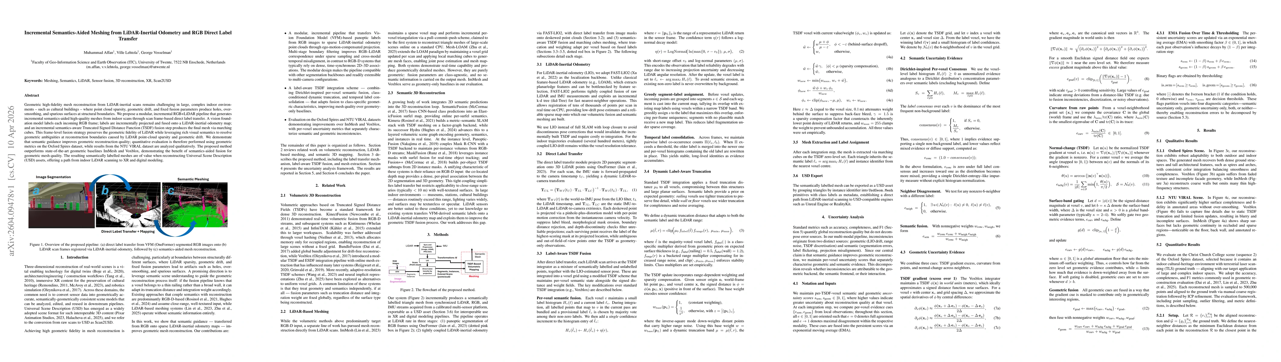
Geometric high-fidelity mesh reconstruction from LiDAR-inertial scans remains challenging in large, complex indoor environments -- such as cultural buildings -- where point cloud sparsity, geometric drift, and fixed fusion parameters produce holes, over-smoothing, and spurious surfaces at structural boundaries. We propose a modular, incremental RGB+LiDAR pipeline that generates incremental semantics-aided high-quality meshes from indoor scans through scan frame-based direct label transfer. A vision foundation model labels each incoming RGB frame; labels are incrementally projected and fused onto a LiDAR-inertial odometry map; and an incremental semantics-aware Truncated Signed Distance Function (TSDF) fusion step produces the final mesh via marching cubes. This frame-level fusion strategy preserves the geometric fidelity of LiDAR while leveraging rich visual semantics to resolve geometric ambiguities at reconstruction boundaries caused by LiDAR point-cloud sparsity and geometric drift. We demonstrate that semantic guidance improves geometric reconstruction quality; quantitative evaluation is therefore performed using geometric metrics on the Oxford Spires dataset, while results from the NTU VIRAL dataset are analyzed qualitatively. The proposed method outperforms state-of-the-art geometric baselines ImMesh and Voxblox, demonstrating the benefit of semantics-aided fusion for geometric mesh quality. The resulting semantically labelled meshes are of value when reconstructing Universal Scene Description (USD) assets, offering a path from indoor LiDAR scanning to XR and digital modeling.
AI Key Findings
Generated Apr 13, 2026
Methodology — What approach did the authors take?
Modular incremental RGB+LiDAR pipeline using FAST‑LIO2 odometry, OneFormer panoptic segmentation, label‑aware TSDF fusion with dynamic, class‑conditioned truncation, and per‑voxel semantic/geometric uncertainty estimation.
Key Results — What are the main findings?
- Semantic guidance reduces reconstruction error to 14.54cm RMSE and increases completeness to 98.55% and F1 to 98.58%, outperforming ImMesh and Voxblox.
- Qualitative evaluation on Oxford Spires and NTU VIRAL demonstrates robust reconstruction of thin structures and high‑frequency details in complex indoor/outdoor scenes.
- Uncertainty analysis shows limited overlap between geometric and semantic errors, enabling decomposition of inconsistencies into source‑specific categories.
Significance — Why does this research matter?
Provides a practical path from LiDAR‑inertial scanning to USD‑compatible, semantically labeled meshes for XR and digital heritage modeling, improving fidelity in sparse, drift‑prone environments.
Technical Contribution — What is the technical contribution?
Label‑aware TSDF fusion with dynamic, class‑conditioned truncation and confidence‑weighted label integration, coupled with per‑voxel semantic and geometric uncertainty estimation.
Novelty — What is new about this work?
First to combine direct RGB panoptic label transfer with incremental LiDAR‑inertial odometry and semantic‑aware TSDF, offering a modular pipeline and uncertainty decomposition absent in prior methods.
Limitations — What are the limitations of this study?
- Odometry drift accumulates over long trajectories, limiting long‑term accuracy.
- Performance depends on camera field‑of‑view, calibration quality, and segmentation accuracy; thin, specular, or cluttered scenes remain challenging.
Future Work — What did the authors propose for future work?
- Integrate loop‑closure or global pose graph optimization to reduce drift over extended scans.
- Develop adaptive voxel resolution or multi‑scale TSDF fusion to better capture thin structures and specular surfaces.
Paper Details
How to Cite This Paper
@article{vosselman2026incremental,
title = {Incremental Semantics-Aided Meshing from LiDAR-Inertial Odometry and RGB Direct Label Transfer},
author = {Vosselman, George and Affan, Muhammad and Lehtola, Ville},
year = {2026},
eprint = {2604.09478},
archivePrefix = {arXiv},
primaryClass = {cs.CV},
}
Vosselman, G., Affan, M., & Lehtola, V. (2026). Incremental Semantics-Aided Meshing from LiDAR-Inertial Odometry and RGB Direct Label Transfer. arXiv. https://arxiv.org/abs/2604.09478
Vosselman, George, et al. "Incremental Semantics-Aided Meshing from LiDAR-Inertial Odometry and RGB Direct Label Transfer." arXiv, 2026, arxiv.org/abs/2604.09478.
PDF Preview
Similar Papers
Found 4 papersFAST-LIVO2: Fast, Direct LiDAR-Inertial-Visual Odometry
Wei Xu, Tong Hua, Zheng Liu et al.
Direct LiDAR-Inertial Odometry and Mapping: Perceptive and Connective SLAM
Kenny Chen, Ryan Nemiroff, Brett T. Lopez
EMV-LIO: An Efficient Multiple Vision aided LiDAR-Inertial Odometry
Bingqi Shen, Yuyin Chen, Rong Xiong et al.
Comments (0)