Interpreting wealth distribution via poverty map inference using multimodal data

Source: ArXiv

AI Quick Summary

This paper proposes a machine learning pipeline to infer wealth distribution using multimodal data, including satellite imagery and crowd-sourced metadata, to create poverty maps. The models effectively predict wealth mean and variance in Sierra Leone and Uganda, showing that metadata is best for rural areas while imagery excels for high wealth quintiles.

Share: Share on X LinkedIn

Summary

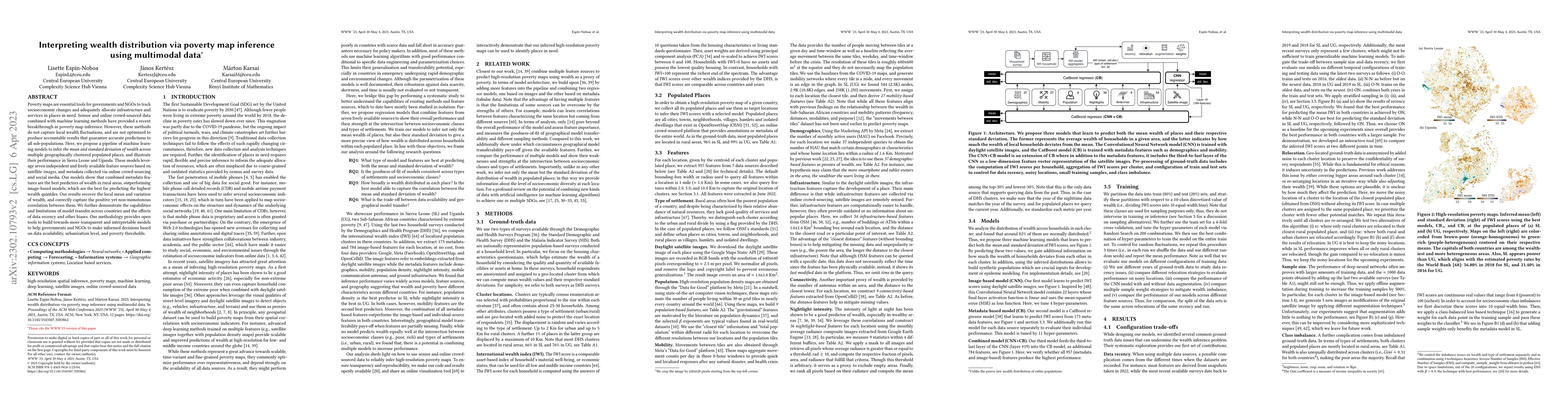
Poverty maps are essential tools for governments and NGOs to track socioeconomic changes and adequately allocate infrastructure and services in places in need. Sensor and online crowd-sourced data combined with machine learning methods have provided a recent breakthrough in poverty map inference. However, these methods do not capture local wealth fluctuations, and are not optimized to produce accountable results that guarantee accurate predictions to all sub-populations. Here, we propose a pipeline of machine learning models to infer the mean and standard deviation of wealth across multiple geographically clustered populated places, and illustrate their performance in Sierra Leone and Uganda. These models leverage seven independent and freely available feature sources based on satellite images, and metadata collected via online crowd-sourcing and social media. Our models show that combined metadata features are the best predictors of wealth in rural areas, outperforming image-based models, which are the best for predicting the highest wealth quintiles. Our results recover the local mean and variation of wealth, and correctly capture the positive yet non-monotonous correlation between them. We further demonstrate the capabilities and limitations of model transfer across countries and the effects of data recency and other biases. Our methodology provides open tools to build towards more transparent and interpretable models to help governments and NGOs to make informed decisions based on data availability, urbanization level, and poverty thresholds.

AI Key Findings

Generated Sep 02, 2025

Methodology

The research proposes a machine learning pipeline to infer mean and standard deviation of wealth across geographically clustered populated places using seven independent, freely available feature sources, including satellite images, metadata from online crowd-sourcing, and social media.

Key Results

  • Combined metadata features outperform image-based models for predicting wealth in rural areas; image-based models are best for predicting the highest wealth quintiles.
  • The models successfully recover local mean and variation of wealth, and correctly capture the positive yet non-monotonous correlation between them.
  • The study demonstrates capabilities and limitations of model transfer across countries and the effects of data recency and other biases.

Significance

This research provides open tools for transparent and interpretable models to aid governments and NGOs in making informed decisions based on data availability, urbanization level, and poverty thresholds.

Technical Contribution

The proposed multimodal architecture, combining sensor and online crowd-sourced data, outperforms satellite images in solving the wealth inference task.

Novelty

This work systematically studies data recency, noisy locations, small training samples, and class imbalance, and conducts an ablation study to evaluate their performance, offering new insights into wealth distribution and poverty mapping.

Limitations

  • The methodology's performance relies on the quality, recency, and coverage of various data sources.
  • Models cannot guarantee the most precise representation of actual wealth due to factors like data recency and sample size.
  • The current implementation primarily works for low- and middle-income countries, relying on DHS survey data, though it can be adapted for new types of ground-truth data and features.

Future Work

  • Address limitations by improving data quality, recency, and coverage.
  • Explore the spatial and temporal transferability of single- and multi-source models with missing data layers at the target population.
  • Combine the best aspects of each model to produce more stable and consistent results across different sub-populations.

Paper Details

PDF Preview

Download PDF

Key Terms

online (0.165)
capture (0.160)
tools (0.154)
combined (0.154)
machine learning (0.146)
models (0.142)
best (0.141)
machine (0.140)

Citation Network

Current paper (gray), citations (green), references (blue)

Display is limited for performance on very large graphs.

Current Paper
Citations
References
Click to view
Title Authors Year Actions

Comments (0)

This website uses cookies to ensure you get the best experience. Learn more